Improving Coastal Vulnerability Index of the Nile Delta Coastal Zone, Egypt
Received: 01-Aug-2015 / Accepted Date: 17-Aug-2015 / Published Date: 27-Aug-2015 DOI: 10.4172/2157-7617.1000293
Abstract
The impact of an atmospheric warming and sea levels 30-70 cm higher than at present on the coastal lowlands of the Nile Delta during the next 50 to 100 years will depends not only on the level of population and economic activities, but also on the degree of coastal development during the next 2-3 decades. The rise in sea level threatens Egypt's long coastal stretch on the Mediterranean Sea with potential damages to, not only the tourism industry, a major contributor to the gross domestic product (GDP), but also to the entire ecosystem. Predicted socioeconomic implications due to human migration, land loss, and soil salinity cause significant concerns. Egypt is facing these challenges responsibly and taking proactive measures to protect its future generations from serious threats, which will increase in the absence of actions taken today. This paper aim to identify the most vulnerable area to sea level rise along the northern Mediterranean coast of Nile Delta. About of 300 km of the coastline was evaluated for seventeen LANDSAT images used. In this paper all available spatial factors (ten factors): geology, geomorphology, topography (elevation above mean sea level), slope, erosion/accretion patterns (shoreline change), mean sea level rise, and coastal protection were incorporate and ranked to develop an Improved coastal vulnerability index (ICVI). That ICVI was developed and used to assess the vulnerability of the coastline of the Nile Delta of Egypt to expected future sea level rise. The produced index was classified into four levels of vulnerability: low, moderate, high, and very high. About 29.64% of 300.8 km of mapped shoreline classified as very high in vulnerability, whereas 2.77% is highly vulnerable, 41.56% is at moderate vulnerability, 3.2% classified as low vulnerability, and 22.84% is a very low vulnerability. Vulnerable hotspots are located mainly along most of Nile Delta coast, southeastern parts of Abu Qir, and southwestern parts of Alexandria city. The remaining coastal areas classified as low to moderately vulnerable (like Alexandria, Rosetta, and New Damietta Cities). According to results obtained, a priority action plan for the Mediterranean coastal zone in Egypt could be modified.
Keywords: Climate change; Coastal change; Coastal protection; Egypt; Improved vulnerability index; Seal level rise
Introduction
Coastal areas are dynamic and complex multi-function systems. A wide number of often-conflicting human socio-economic activities occur in these areas. These include urbanization, tourism and recreational activities, industrial production, energy production and delivering, port activities, shipping, and agriculture. Coastal systems are also characterized by important ecological and natural values; their high habitat and biological diversity are fundamental to sustain coastal processes and provide ecosystem services, which are essential also for human well-being. Sea level rise (SLR) and extreme water levels are the most important signs of the impacts of climate change causing major threats to human beings around the world particularly in fragile zones like Deltas and low lying coastal areas. The potential impacts increase when populations and their related economic activities are highly concentrated along the coastal zones [1].
The fourth assessment report of the Intergovernmental Panel on Climate Change (IPCC) indicated that the global mean sea level has been rising during the 20th Century at an average rate of 1.7 ± 0.5 mm/ yr (between 1993 and 2003, the rate was faster, about 3.18 ± 0.5 mm/yr) [2]. Global climate models have predicted a global SLR of between 0.18 mm/yr. and 0.59 mm/yr. by the end of the 21st century [3]. Overall, sea level continues to rise at a rate of 3.2 mm/yr [4].
Many authors study the global mean sea level rising, it estimated as 50-140 cm, later corrected to 75 to 190 [5]; Horton et al. [6] estimate 54 to 89 cm; Ginsted et al. [7] estimate 72 to 160 cm; and Jevrejev et al. [8] estimate the sea level rise between 60 and 160 cm. It can be notices that all estimates are substantially higher than the estimate of IPCC [9].
Due to low elevation in the Nile delta region, Egypt was considered one of the top five countries expected to be mostly impacted with sea level rise. Egypt should identify the most endangered regions, as SLR not only intimidates coastal area, but coastal ecosystems and settlements as well. The coastal zone of the Nile Delta was subjected to the impact of climate change that may lead to sea level rise (SLR), so it is a vulnerable area especially in low land areas of Alexandria, Beheira, Port Said and Damietta. In Alexandria, if sea level rise is between 0.5 m and 1.0 m over this century and if no action was taken, an area of about 30% of the city will be lost due to inundation [10]. The adaptation measures that were identified to deal with the impact of climate change on coastal zone areas include beach nourishment, construction of groins and breakwaters, tightening legal regulations, integrated coastal zone management and introducing changes in land use [10]. For those adaptation strategies in Alexandria, for example, authorities were spending US$300 million to construct concrete sea walls to protect beaches from rising seas. Egyptian ministry of environmental affairs is also preparing a “National Strategy Study” on adaptation, including a vulnerability index to pinpoint the most endangered regions. The produced vulnerability index has a value ranged from 0 to 10 (where 10 is excellent resistance to SLR), which helps to indicate where should the adaptation start [11].
Indicators are a way of quantifying the level of vulnerability of any environmental system, like coastal system in our case. Many studies and approaches have been implemented to assess vulnerability of different coasts to SLR [12]. The coastal vulnerability index (CVI) is one of the most commonly used and simple method to assess coastal vulnerability to sea level rise, in particular due to erosion and/or inundation [13]. The CVI provides managers to identify regions where risks may be relatively high could use a simple numerical basis for ranking sections of coastline in terms of their potential changing that. The CVI results can be display on maps where there is a highest vulnerability to shoreline changes [13].
Some authors [13] incorporated six variables (geomorphology, coastal slope, sea-level trends, shoreline displacement (erosion/ accretion), tidal ranges, and wave heights) to calculate the CVI, while others calculated it using nine variables, namely: rock type, coastal slope, geomorphology, barrier type, shoreline exposure, shoreline change, relative sea level rise, mean wave height, and mean tide range. The selection of the number and type of indicators to use in a given coastal setting depends on the nature of the near-term coastal planning, availability of date, challenges and questions.
Study area
The Nile Delta with its classic fan shape has been evolving since Upper Miocene time. The surface of the Nile Delta represent only 2.3% of the area of Egypt, but as much as 46% of the total cultivated area, also it contains coastal lagoons represent 25% of total Mediterranean coastal wetlands. The Nile Delta coast mainly built by the weathering products that carried from south by the river Nile, so it has a fragile boundary that controlled by a combination of some environmental factors (such as waves, currents, tides ...etc.) and river discharge [14]. Because of that, it became a subject to frequent changes. The area under investigation represents the northern coastal zone of the Nile Delta with about 290 km coastal line (Figure 1). About half of Egypt’s 80 million people live in the Delta region. Outside of major cities, population density in the delta averages 1,000 persons/km2 or more. Alexandria is the largest city in the delta with an estimated population of more than 4 million. The Delta has a hot desert climate as the rest of Egypt, but its northernmost part, as is the case with the rest of the northern coast of Egypt, which is the wettest region in the country, has relatively moderate temperatures, with highs usually not surpassing 31°C in the summer. Only 100- 200 mm of rain falls on the delta area during an average year, and most of this falls in the winter months [15].
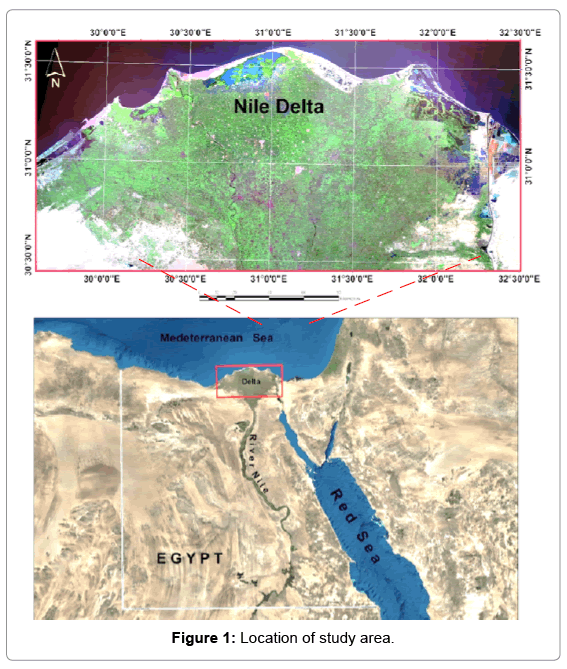
Figure 1: Location of study area.
Methodology And Results
Ten different variables were used in this study to measure the vulnerability to SLR. (1) Geology (rock type); (2) elevation (shoreline exposure); (3) coastal slope; (4) geomorphology; (5) shoreline change, and (6) the presence of coastal protection, whether natural or manmade. (7) The relative sea level rise; (8) Land subsidence; (9) Population Density; and (10) Socio-economic status. Other variables like wave height and tidal range were not use as they are almost homogenous in the study area. A five km buffer used as a maximum effective distance from coastline. All used variables GIS layers cut using the 5 km buffer layer.
The improved coastal vulnerability index (ICVI) was use to map the relative vulnerability of the coastline to future sea level rise; it ranks the ten variables in terms of their physical contribution to sea-level rise-related coastal change. The rankings for each input variable were combined and reclassified into index values using 50 m × 50 m grid cells covered the Nile Delta coastal zone. The ICVI highlights those regions where the physical impacts of SLR will be most severe. The ICVI was classified into five different classes using ranges (0-20%, 20%- 40%, 40%-60%, 60%-80% and 80%-100%), corresponding to very-low, low, moderate, high, very-high vulnerability.
Geology (rock type)
The rock type variable represents the surface geology of the study area occurring at, or underlying, the shoreline. Data for the rock type variable were digitized from the published geological map of Egypt at a scale of 1:500,000, produced by the Egyptian General Petroleum Corporation, year 1987 [16]. The coastal line is update using base maps satellite images in ARCGIS.
The resulted geologic map (Figure 2) indicates that all rock types forming this region are from quaternary age. Large areas of the region are composite of Nile silt especially along western parts of Rosetta promontory. Sands forming sand dunes are the common rock type in the eastern part of Nile Delta and Abu Qir Bay. Sabkha deposits and marsh, silt, clay evaporates are characterizing the central parts of AbuQir Bay and Eastern parts of Delta. Sands, gravels and recent coastal deposits are found along the Delta between the two branches of River Nile. Most of western part of the study area is characterize by Alexandria formation, which represent the calcarenite bars Pleistocene age that forms mainly from chalky, marly, arenaceous oolitic beach ridges. The stabilized dunes were located a way of coastline, except in Rosetta region it is close to the coast.
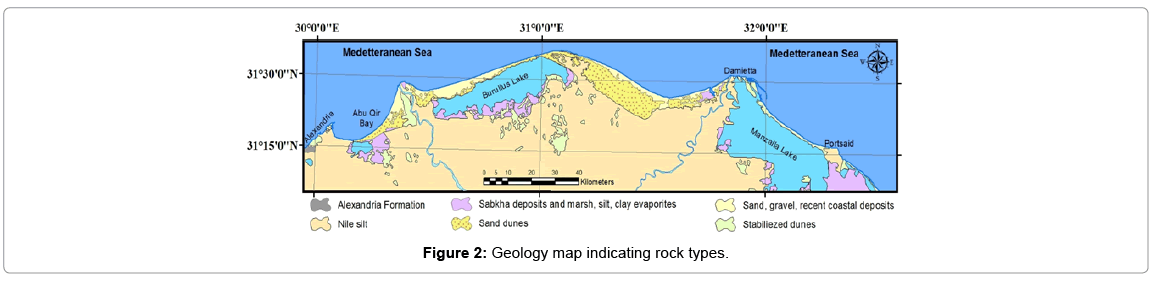
Figure 2: Geology map indicating rock types.
Elevation (shoreline exposure)
Elevation is generally one of the most critical factors in assessing potential impacts of SLR on coastal areas. Shuttle Radar Topography Mission (SRTM) that considered as one of the most complete highresolution digital topographic database of earth was used to produce digital elevation model for the study area. The extracted elevation values from SRTM were interpolated to raster, then converted to vector lattice that support accurate further surface calculations like contouring, slope, and change in the value over distance (elevation) (Figure 3).
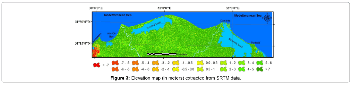
Figure 3: Elevation map (in meters) extracted from SRTM data.
Coastal slope
Coastal slope is link to the susceptibility of a coast to inundation by flooding and to the rapidity of shoreline retreat, thus, slope is one of the important factors to be consider in estimating the impact of sealevel rise [17]. The slope was calculated in degrees using ArcGIS spatial analyst extension and the input raster was obtained from the digital elevation model that extracted using SRTM data (Figure 4). The slope analysis revealed that more than 79% of the study area is dominate by moderate slope values (19% having 8º and 60% having 9° slopes). The rest of the area dominated by small slopes (more than 15% have a onedegree slope).
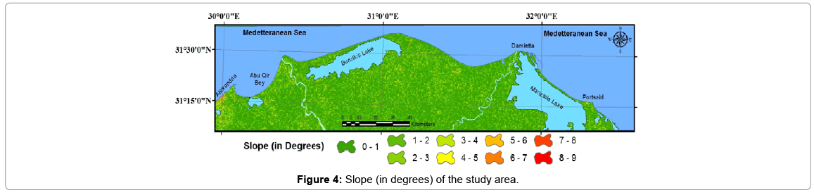
Figure 4: Slope (in degrees) of the study area.
Geomorphology
The geomorphology variable is affecting the total vulnerability of the coast, as it detentions the actual landforms in the foreshore and backshore zones. Data for geomorphology variable have two main sources: 1) the geological map of Egypt, by the Egyptian General Petroleum Corporation, scale 1: 500000; 2) LANDSAT ETM image of the study area. The resulted geomorphological units are: i) urban, ii) Nile silt, iii) stabilized dunes, iv) cultivated Deltaic areas, v) marsh, silt, and sabkha deposits, vi) reclaimed dunes and coastal flat, vii) sand, gravels, and recent coastal deposits, and viii) lagoons (from west to east Idku, Burullus, and Manzalla) (Figure 5).
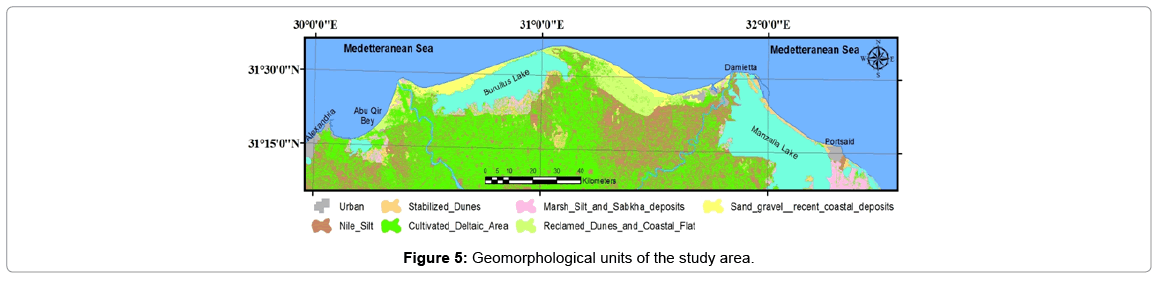
Figure 5: Geomorphological units of the study area.
Shoreline change
Most studies of the shoreline changes were on a local scale (either for Rosetta or for Damietta promontories); few are concern the whole Delta coastal zone. Detailed assessments of the rates of shoreline change rates have been compile-using DSAS (digital shoreline analysis system) [18]. A seventeen LANDSAT images were used to extract shorelines change rates over a 43 years span (starting from 1972 to 2015). There is a high variation in changes along the costal line, as it reversed several time. The shoreline is classified in 3 types: a) shoreline in erosion that has its maximum rates along the Rosetta promontory (-106 m/yr.) and Damietta promontory (-10.4 m/yr.), significant erosion has also occurred along the central bulge of the delta coast, but at a lesser rate (-6.5 m/yr.). b) Shoreline in accretion, which have its maximum rates at Abu Qir (9.9 m/yr.), east Rosetta Promontory (20.9 m/yr.), west Damietta harbor (15 m/yr.), and along the western barrier on the Burullus lagoon inlet (4.9 m/yr.). c) Shoreline with no significant time variation (nodal points) that located between erosion and accretion zones.
Coastal protection
The Nile Delta coastal zone could classify according to the presence of coastal protection, whether natural or manmade. The 2012-2017 plan of the Egyptian Authority for Coastal protection has several projects of a total value of about 770 million Egyptian pounds. These projects include enhancement of Rashid protection wall, protecting the beaches of Alexandria, Port Saied and Al-Arish, Damietta, Kafr E-Shikh, and El-Malaha area east of Port Saied. Figure 6 illustrates the protection along the Nile Delta coast. The protection classified into three main groups; i) Unprotected areas, ii) Natural protection (like sand dunes), and iii) Constructional protection (like Rosetta and Damietta walls).
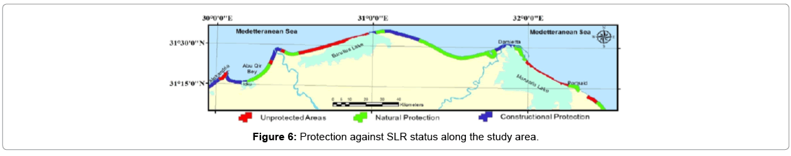
Figure 6: Protection against SLR status along the study area.
Relative sea level rise
The relative sea level rise is not a factor spatially distributed as the other factors, as most of Nile Delta coastal area are generally low elevated and composed mainly of low angle slopes. The direct inundation of sea level rise is not the only impact, but there are also some other impacts like salt-water intrusion and loss biodiversity. Global average sea level rise has an average rate of around 1.8 mm/yr. over 1961 to 2003 and at an average rate of about 3.1 mm/yr. from 1993 to 2003 [19].
Land subsidence
Egyptian delta coasts are vulnerable to land subsidence. Stanley and Warne [20] survey its rates in Holocene period by pore holes. Geological analyses of radiocarbon-dated cores across the northern delta are used to interpret the interaction of sea-level changes, climatic oscillations, subsidence, and transport processes during the past 35,000 years. Recognition of long-term trends of these natural factors provides a basis to evaluate the profound impact of human activity and to assess future changes in the Nile delta ecosystem (Figure 7). Tide gauges data from the Coastal Research Institute of Alexandria, and work carried out using Radar satellite revealed a land subsidence of about 1.6 mm/ year at Alexandria, 1.0 mm/year at Al-Burullus, and 2.3 mm/year at Port Said.
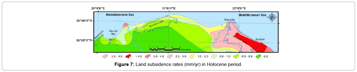
Figure 7: Land subsidence rates (mm/yr) in Holocene period.
Population density
Two GIS layers for population districts distribution was creating, the attribute (tabular) data describing population number and number of families for each district used to indicate the areas of high population density and large number of families, those areas would the most vulnerable to SLR. The source of the tabular data is Central Agency for Public Mobilization and Statistics (CAPMAS) based on the Egyptian census operation in 2006 (Figures 8 and 9).
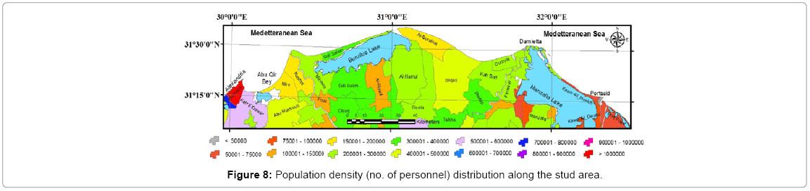
Figure 8: Population density (no. of personnel) distribution along the stud area.
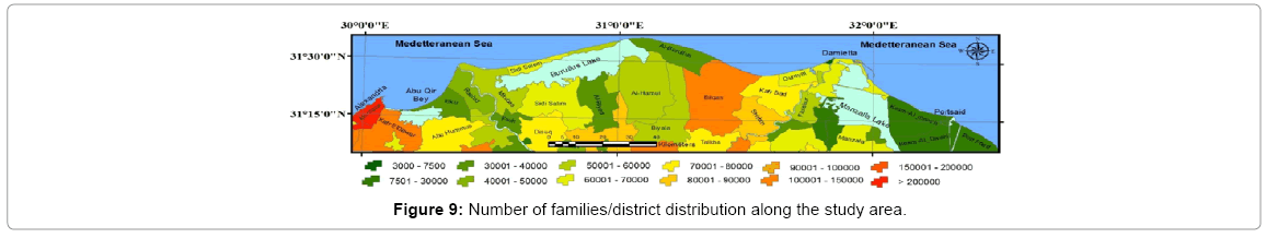
Figure 9: Number of families/district distribution along the study area.
Socio-economic status
Data from Central Agency for Public Mobilization and Statistics (CAPMAS) based on the Egyptian census operation in 2006 was used to define population distribution by main occupations and sex 15 years and above in each district. The status of occupation classified into number as 1) Legislature, administrative and managerial workers; 2) Professional workers; 3) Technicians and assistants; 4) Clerks and related workers; 5) Commercial and service workers; 6) Farmers, fishers and hunters; 7) Craftsmen and related workers; 8) Production workers and related workers; and 9) Un-skilled workers. The representative occupation (higher numbers) for each district illustrated in Figure 10.
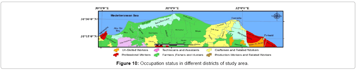
Figure 10: Occupation status in different districts of study area.
Data ranking
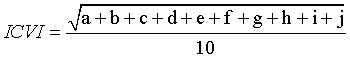
A linear scale used to rank the vulnerability variables, one represents the lowest risk and a value of five represents the highest risk. The extracted ten variables are used to formulate the ICVI for each cell of the coastline zone. A five-kilometer buffer zone of coastline is used as judgment area; this zone is divided into 50 m × 50 m cells, for each cell the vulnerability value is assigned for each specific data variable. Finally, ICVI calculated as the square root of the product of the ranked variables divided by the total number of variables.
Where,
a: Geology (rock type); b: Elevation; c: Coastal slope (degrees);
d: Geomorphology; e: Shoreline change; f: Coastal protection;
g: The relative sea level rise; h: Land subsidence; i: Population density;
j: Socioeconomic status.
Discussion
Ranks for each 50 m × 50 m cell in the coastal buffer zone were estimated, all numerical variables were assigned a risk ranking based on data value ranges, while the non-numerical (like geomorphology and geology) variables are ranked according to the relative resistance of a given landform to erosion and the bedrock occurring at, or underlying, the shoreline. While, other non-numerical variables like socioeconomic were rank according to its influences on further adaptation measures for sea level rise.
The elevation variable has been classified in very low if greater than 4m above mean sea level (MSL), low in range 2-3 m above MSL, moderate in the range 0-1 above MSL, high from -1 to -2m above MSL, very high if less than -3m above MSL. Coastal slopes were considered two classified thematic layers: very low and very high at values between (>9° to 0.0-0.5), maximum slopes in the area not exceed 9°. The mean sea-level rise variable has been assigned a medium value (2.5 mm/yr.) according to the global average sea level rose. Shorelines with varied erosion/accretion rates were rank into four vulnerability classes ranged from very low to very high values. Coastal protection variable classify the coast into three categories with unprotected, natural protected, and constructional protected. Land subsidence variable also classify the coast zone into five categories according to its subsidence rates in Holocene period and tide gauges data. Finally, the socioeconomic and population variables were ranked according to population density (and number of families) and main occupation in each district, all the above ranks summarized in Table 1. Vulnerability levels examples of ranked ten variables illustrate in Figure 11.
| Variable | Ranking of Coastal Vulnerability | |||||
|---|---|---|---|---|---|---|
| Very Low | Low | Moderate | High | Very High | ||
| 1 | 2 | 3 | 4 | 5 | ||
| a. | Geology | Stabilized dunes | Sand dunes | Recent coastal deposits | Nile silt | Sabkha |
| b. | Elevation | >4m | 2m to 3m | 0 m to 1m | -1m to -2m | <-3m |
| c. | Coastal slope | >9 degree | 8 degree | 6-7 degree | 1–5 degree | |
| d. | Geomorphology | Stabilized dunes | Reclaimed dunes | Sand gravels | Nile silt | Marsh silt and sabkha |
| e. | Shoreline change | Almost null | 6 to 10 m/yr.> 10 m/yr. | |||
| f. | Coastal protection | Natural protection | Constructional | Unprotected | ||
| g. | sea-level rise | Moderate values along the study area (1.8 to 3.1 mm/yr.) | ||||
| h. | Land subsidence | 1 mm/yr.2 mm/yr.2–3 mm/yr.>4 mm/yr. | ||||
| i. | Population density | 4 | 1× 10⁵–3× 10⁵ | 4× 10⁵–5× 10⁵ | 6× 10⁵–9× 10⁵ | >1× 10⁶ |
| j. | Socioeconomic status | Professional | Technical | Production | Craftsmen | Farmers and Fishermen |
Table 1: Ranking of coastal vulnerability of different variable.
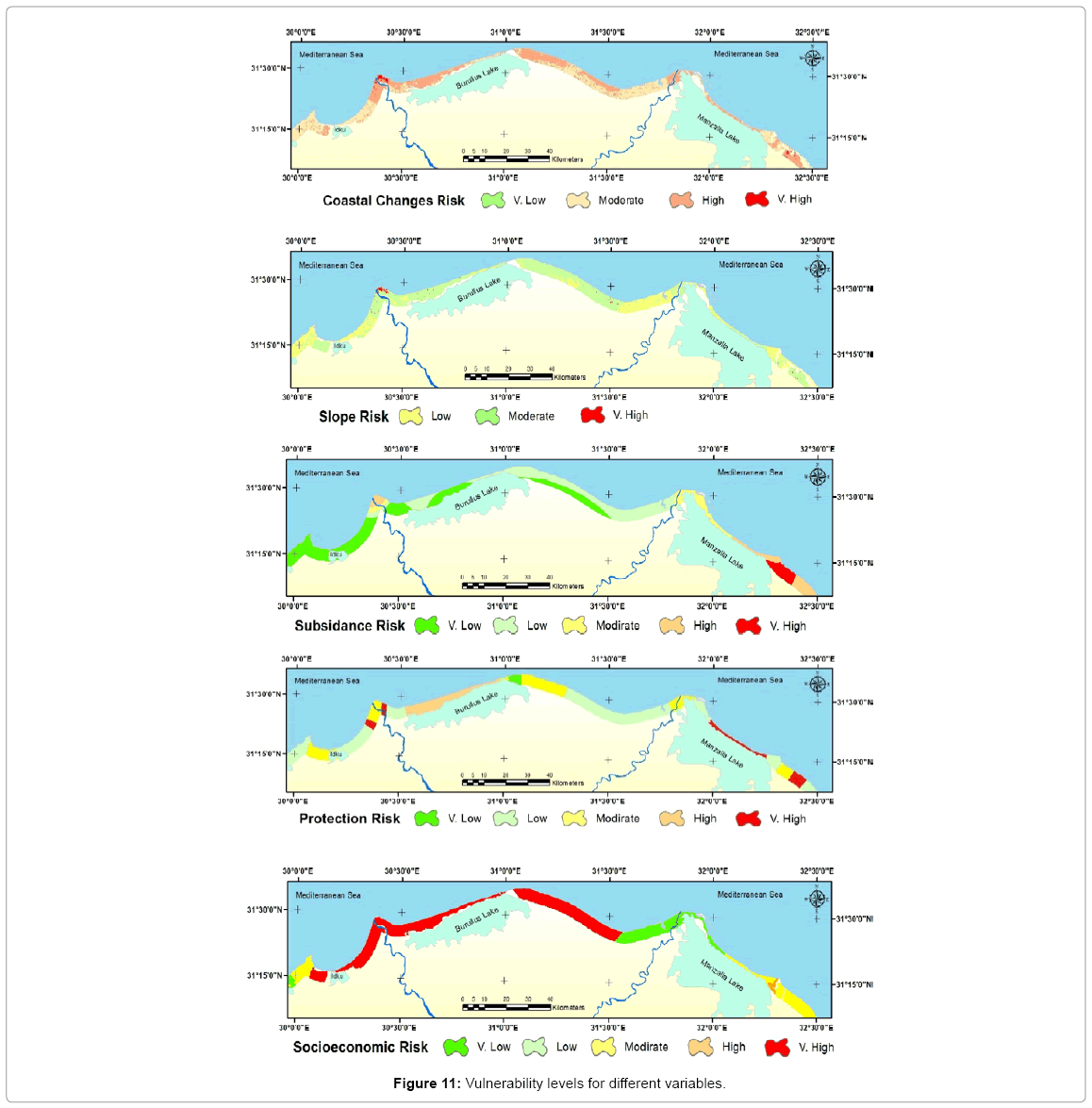
Figure 11: Vulnerability levels for different variables.
Finally, by using weighted overlay module in ARC GIS (that module overlays the 10 used variables layers, multiplying each by their given weight and summing them together), to produce the final Improved Coastal Vulnerability Index (ICVI), which categorized into five classes: very low; low; moderate; high; and very high.
About 29.64% of 300.8 km of mapped shoreline classified as very high in vulnerability (89.15 km), whereas 2.77% is highly vulnerable (8.32 km), 41.56% is at moderate vulnerability (125 km), 3.2% classified as low vulnerability (9.62 km), and 22.84% is a very low vulnerability (68.72 km).
Locations along the coast which are considered highly to very highly vulnerable are located in the eastern parts of Rosetta and Damietta branches and around Gamasa, while the other parts were classified as moderate to low vulnerability areas, Alexandria city was classified as very low vulnerable due to its rocky beaches. A map of improved calculated coastal vulnerability index is shown in Figure 12.
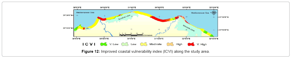
Figure 12: Improved coastal vulnerability index (ICVI) along the study area.
Conclusion
A final map representing the calculated ICVI has been created based on data for ten variables. Adding the variables population density, number of families and socio-economic status improve the index as they reflect the main stakeholders in the coastal zone who are affected by SLR and any climate changes. Using GIS techniques, the ICVI presented in this study provides an understanding view about the relative potential of coastal change to expected SLR. Results obtained could use as an input for the Governorate environmental decision system, to help in identifying the most vulnerable areas to future sea level rise; a priority action plan for the Egyptian Mediterranean coastal zone could be update modify.
References
- McGranahan G, Blak D, Anderson B (2007) The rising tide: Assessing the risks of climate change and human settlements in low elevation coastal zones. Environ Urbanization 19: 17-37.
- Solomon SD, Manning QM, Chen Z, Marquis M, Averyt KB et al. (2007) The physical science basis, in: Intergovernmental Panel on Climate Change. Cambridge University Press, Cambridge, USA.
- Meehl GA, Stocker TF, Collins WD (2007)In: Intergovernmental Panel on Climate Change, Cambridge University Press, Cambridge, USA.Global clim projections, pp.749-844.
- Merrifield MP, Thompson E, Leuliette G, Mitchum D, Chambers S, et al. (2014) [Global Ocean] Sea level variability and change. Bull AmMeteorological Soc (BAMS) 96: S82-S85.
- Vermeer M, Rahmstorf S (2009) Global Sea Level Linked to Global Temperature. P Natl AcadSciUSA 106: 21527-21532.
- Horton R, Herweijer C, Rosenzweig C, LiuJP, Gornitz V, Ruane AC (2008) Sea Level Rise Projections for Current Generation CGCMs Based on the Semi-Empirical Method. Geophys Res Lett 35.
- Ginsted A, Moore JC, Jevrejeva S (2009) Reconstructing Sea Level from Paleo and Projected Temperatures 200 to 2100 AD. Clim Dynam 34: 461-472.
- Jevrejeva S, Moore JC, Grinsted A (2010) How Will Sea Level Respond to Changes in Natural and Anthropogenic Forcings by 2100. Geophys Res Lett 37.
- Aymen AS, Mamdouh MEH, Rifai IR, Waleed MTF (2014) An Integrated Web Mapping Solution to Assess the Effect of SLR on the Northern Coast of EGYPT – EGSLR. Bandrova et al. (edn.), Thematic Cartography for the Society, Lecture Notes in Geoinformation and Cartography, Springer International Publishing Switzerland 2014: 23-31.
- El Raey M (1997) Vulnerability assessment of the coastal zone of the Nile Delta of Egypt to the impacts of sea level rise. Ocean Coastal Manage 37:29-40.
- Batisha AF (2012) Adaptation of Sea Level Rise in Nile Delta Due to Climate Change. J Earth Sci Climate Change 3:114.
- Cristina DL, Eleonora C, Eduardo K, Pietro T, Luigi T (2015) Saltwater contamination in the managed low-lying farmland of the Venice coast, Italy: An assessment of vulnerability. Sci Total Environ533: 356-369.
- Sabah SA (2012) Development of Coastal Vulnerability Index for the Kingdom of Bahrain. J Earth Sci Eng 2: 228-236.
- El-RM, Nasr SM, MM El-Hattab, Frihy OE (1995) Change Detection of Rosetta Promontory over the Last Forty Years. Int JRemote Sens 16: 825-834.
- Frihy OE (2003) The Nile Delta-Alexandria coast: vulnerability to sea level rise, consequences and adaptation. Mitigation Adaptation Strategies Global Change 8: 115-138.
- NageswaraKR, Subraelu P, Venkateswara TR, Malini BH, Ratheesh R, et al. ( (2008)) Sea-level rise and coastal vulnerability: An assessment of Andhra Pradesh coast India through remote sensing and GIS. J Coast Conserv 12: 195-207.
- http://woodshole.er.usgs.gov/project-pages/dsas/version4/images/pdf/DSASv4_2.pdf.
- UNFCCC (2004) Compendium of Methods and Tools to Evaluate Impacts of, and Vulnerability and Adaptation to, Climate Change. UNFCCC: Bonn, Germany.
- Stanley DJ, Warne GA (1993) Nile Delta: recent geological evolution and human impact. Science 260: 628-634.
Citation: El-Hattab MM (2015) Improving Coastal Vulnerability Index of the Nile Delta Coastal Zone, Egypt. J Earth Sci Clim Change. 6: 293. Doi: 10.4172/2157-7617.1000293
Copyright: © 2015 El-Hattab MM. This is an open-access article distributed under the terms of the Creative Commons Attribution License, which permits unrestricted use, distribution, and reproduction in any medium, provided the original author and source are credited.
Share This Article
Open Access Journals
Article Tools
Article Usage
- Total views: 17985
- [From(publication date): 10-2015 - Apr 25, 2024]
- Breakdown by view type
- HTML page views: 13321
- PDF downloads: 4664