Vulnerability of Natural Resources in Tunisian Arid Zones facing Climate Change and Human Pressure: Toward Better Target Actions to Combat Desertification
Received: 24-Jan-2015 / Accepted Date: 25-Feb-2015 / Published Date: 03-Mar-2015 DOI: 10.4172/2157-7617.1000260
Abstract
The main challenges of Tunisian arid areas is better understand desertification and better adapt decisions to uncertainties that arise in complex interactions between the socio-economic and biophysical dynamics at different spatial and temporal scales. This understanding is increasingly necessary to better target actions and improve coping strategies. The objective of this work is to assess the vulnerability of natural resources and the risk of desertification at the local scale, in a case study (Oum Zessar watershed) located in the south-east of Tunisia. The assessment is carried out through an analysis of different human and biophysical causes and driving forces, such as natural resources uses and climate change. It is based on geographical (landscape), integrated (socio-economy, biophysics) and multi-actors (research-decision) approaches, associated with reproducible methods and models to assess the risk of desertification, and to better target future combating actions. The work led to the development of desertification risk indexes (based on spatial integration of biophysical and socio-economic functioning through modeling), facing several scenarios of climate change and human pressure. It shows that the same level of risk in one place or another may have differentiated causes, which could help public policy in their fighting against desertification.
Keywords: Desertification risk, Vulnerability, Spatial integration, Climate change, Human pressure, Decision support, Tunisian arid zones
Introduction
Desertification is part of the global questions for which we are all concerned. It has effects locally on the affected territories on all aspects of life, not only environmental but also socio-economic which constitute significant obstacles to sustainable development. It is a threat for man and for the Earth in the short, medium and long term: loss of food production and famine, social crises, refugees, decrease of the carbon storage in plants and in the soil, reduction of biodiversity, and many other major disasters hardly reversible. For example, according to UNESCO in 2006 [1], at least 25% of the surface of the continents (more than 100 countries) are affected by desertification (36 million km²), where live 16 percent of the world's population.
Despite of multitude plans to prevent from this phenomenon, such as the United Nations Convention to Combat Desertification (UNCCD), the desertification continues to progress with a rhythm of 260,000 km2 per year in the world. Enormous economic consequences have been identified and estimated in last few decades. A simple monetary approximation of ecosystems potential, by the World Bank, has given the amount of 42 billion US dollars [1], whereas the annual cost of fighting against desertification reached only 2.4 billion US dollars. Desertification costs to African States about 9 billion US dollars per year. In fact, two thirds of the continent was deserts or arid lands, which suffer from degradation in various degrees. The droughts are both severe and frequent and the continent has serious consequences in terms of poverty, population movements and food security [2].
Tunisia, having ratified the UNCCD, has deployed great efforts for at least twenty years in terms of combating desertification in the framework of its national action plan. Despite of the undeniable efforts of the Tunisian Government, the resilience of the local population and the advanced research in terms of natural resource management and fighting against desertification - whose immediate effects are clearly visible, the results have not been up to expectations. The carried out actions demonstrate incomplete success, and desertification persists in these areas, as shown by numerous field examples (sand movements, etc.) [3,4]. In fact, the actions implemented by the Tunisian Government have been carried out in a technical way, which often did not take into account the diversity of climate, biophysical and socio-economic conditions of the affected areas. This result has created a kind of dissatisfaction among researchers, policy makers and resource managers, but also the local population, resulting from a lack of understanding of the failures of actions, or even of desertification itself.
Tunisian arid areas are nowadays worrying risks affecting the balance and even the viability of their production systems and sustainability of natural resources [5-8]. This environmental situation is considered as a brake on development.
This research is a part of the problem of fighting against desertification in Tunisian arid areas. It tries to assess the risk of desertification by analyzing and quantifying the respective effects of Human, climate condition and availability of resources, in a case study: the watershed of the Oum Zessar, which is a part of Tunisian arid regions. This assessment is based on geographical (landscape), integrated (socio-economy, biophysics) and multi-actors (research-decision) approaches, associated with reproducible methods and models to assess the risk of desertification, and to better target future combating actions. The tool used is the spatial and integrated modeling called LEIS: Local Environmental Information System [9-13].
Several scenarios of climate change and human pressure are then applied to analyze the effects of each cause or driving force on the vulnerability of natural resources at the local scale. The final issue is to demonstrate that the same level of risk in one place or another may have differentiated causes, which could help public policy in their fighting against desertification.
Methods And Materials
Study site
The Oum Zessar Watershed is located in south-east of Tunisia in Medenine governorate with 36000 ha surface area and around 24000 inhabitants (Figure 1). This site is part of Tunisian Jeffara that presents a lower arid Mediterranean climate and a 160 to 220 mm average rainfall per year with an average of 30 days of rain.
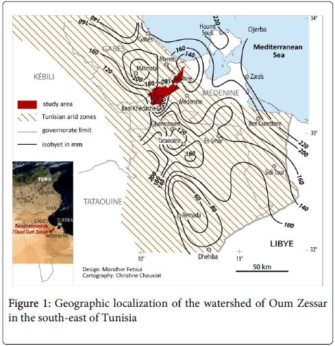
Figure 1: Geographic localization of the watershed of Oum Zessar in the south-east of Tunisia
Analysis of precipitation regime and deficit of water, from rainfall series of 27 years (1976-2003) collected from weather stations installed in the study area, shows that the local climate is characterized by an inter-annual and seasonal irregularity and variability of rainfall. The rainfall frequency analysis shows that 33 percent of years (within the period of 27 years) are very dry to dry, 25 percent are normal and 42 percent are wet to very wet years. This analysis shows also that drought happens generally once, twice or three times every four years [13]. The alternation of dry and wet years has impacts on local actors and population strategies in these arid zones.
The temperature plays a very important role in the rate of air moisture, affecting the level of plants transpiration and rainfall in these arid zones. It is affected by the proximity of the sea to the east and by the effects of altitude at the level of mountains. The annual average temperature on the period of 27 years at Oum Zessar (1976-2003) is 20°C. June, July and August are the warmest months with an average temperature of 26°C. The coldest months are December, January and February with an average temperature of 12°C. The thermal amplitude between the hottest month (August: 29.5°C) and the coldest month (January: 10.8°C) is very high (18.7°C) [13].
Water resources are a major constraint for pastoral (sheep and goats) and agricultural (cereals and tree cultivation) activities [3]. In the study area, we distinguish between two types of water resources: surface and ground water. The surface water resources are constituted by the runoff. Given the general weakness of rainfall, the volume of runoff water is low [11]. Even during the rainy season, the low rainfall does not allow to generate real river networks at the watershed. In the governorate of Medenine, this volume is estimated at 16 million m3 per year [14]. Approximately, 11 million m3 are mobilized (68 percent) by water harvesting techniques, or recharge wells or with cisterns. Nearly 30,000 cisterns in the Governorate of Medenine can store nearly 1 million m3 [14]. The scarcity of superficial water in Tunisian arid zones is relatively compensated by the underground water resources. The south of Tunisia, which is rich in aquifers, stores in fact 25 percent of water reserves of Tunisia [3]. The shallow aquifers resources, feed from the infiltration of rain water, and more rarely, escalation of deep aquifers, are valued at 12.5 million m3 [11]. In fact, these aquifers are the subject of a very old exploitation from surface wells. The mobilization of this groundwater is very high, with an average rate of overexploitation of 140 percent [11]. This overexploitation has led to a gradual salinization of the water and to a decrease of the piezometric level. The deep aquifers constitute the most important resources in the Tunisian dry lands, especially in the Governorate of Medenine. But, these deep aquifers represent a very low renewal rate and a poor chemical quality of the water. The high costs induced by the mobilization and transfer of these waters appear as factors limiting their exploitation. The mobilization of the water of these aquifers is realized more often from deep wells for irrigation, or drinking or used in industries and tourism sector.
This site is a typical agro-pastoral interlocked area with the gradual and in some areas accelerated expansion of cropland at the expense of the natural rangelands. In fact it has very significant eco-environment vulnerability, degraded vegetation in rangelands, intensification of agricultural use in plain areas which have led to water resources overuse and to land degradation [15]. This region has been a target area of the main national strategies for natural resource and combating desertification (water and soil conservation, water resources, pasture and rangelands, sand encroachment, rural development).
Main desertification issues are Human pressure having markedly increased in recent years due to changes in socio-economic policies [4,6]. The effect of this has been an increasingly irrational use of natural resource: i) Accelerated expansion of rainfed agricultural (especially olive tree and annual crops, cereals, etc. and irrigation system, ii) Significant change of agrarian system and land use, and iii) Development of multi sectors activities for income generation (urbanization, services, migration etc.). Climate variability and climate change are considered also as major causes of the state of severe degradation in this study site [16].
Methodological approaches and used tools
This research is based on spatial, integrated, multidisciplinary and multi-actors approaches, in order to assess the environmental situation related to land degradation and qualify the risk of desertification.
The present work consists on comparing different types of spatial information plans for a better understanding of the overall mechanisms of the territorial system, but also to distinguish the specific local states of this system, represented in the field by different types of landscape. The landscape typology is based on the expertise and participation of resource persons (the heads of villages), researchers from different disciplines (ecology, geography, agronomy, geology, etc.), and technical decision-makers (agents of regional stations of agricultural development). It allows the evaluation and the monitoring of desertification risks at the local scale. The landscape types are then considered as an operational level for decision making [17,18].
Our work consists primarily to integrate, at the local scale, socio-economic and biophysical information, through the LEIS environmental modeling. This latter mobilizes the landscape as resulting from the interactive dynamics of the system that can be recreated and represented spatially following a formalization and geospatial rules. It structures the territory into SRU (spatial reference units) on which we can quantify the natural resources vulnerability levels or indicators face to multiple uses of these resources. These spatial indicators are thus constructed from spatial integration of allocation rules and practices of resource usages with the local biophysical conditions and availability of resources. The SRU come from the intersection of three geographic plans. The first one is built through remote sensing, geographic information system and field measures. It represents the biophysical characteristics (land cover, morphology, soils, etc.). This information plan expresses the functioning of ecological systems through their resource production levels and it structures the territory to homogenous units called landscape units (LU) [13]. The second information plan represents the multiple agriculture practices at the local scale. This plan is built by the way of field surveys and expresses the strategies of local actors/farmers and their multiple uses of natural resources. It structures the territory to homogenous practices or combined practices units (CPU) [9,12]. The third plan defines Climatic Units (CU), which are spatial units receiving the same average amount of rain over a period of more than thirty years, generating a well-defined production resources and specific coping strategies (specific logic of land use, production strategies, resources uses, etc.).
The SRUs have then the information of the nature, the availability and the level of uses of natural resources at the local scale. The vulnerability of resources is evaluated on these SRU by type of use (agricultural, pastoral, forest) by integration of the three information plans (LU, CPU and CU). It represents the ratio between the availability of resources (A), and the uses of these resources (U) for each type of use, but also for all types of use (Figure 2).
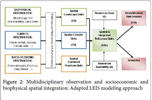
Figure 2: Multidisciplinary observation and socioeconomic and biophysical spatial integration: Adapted LEIS modeling approach
Clusters have been carried out in order to build three classes of indices, which can be associated with a qualifier, indicator of pressure degree of the multi-use of vegetation resources. This work is based on statistical classification methods. The three classes identified are:
• Class 1: Low to medium risk of multi-use of resources, derived from a use which does not access 40 percent of the total vegetation availability (U/A < 0.4);
• Class 2: High risk of multi-use of resources, corresponding to a use which can affect 80 percent of the available resources (0,4 ≤ U/A < 0.8);
• Class 3: Very high risk of multi-use of resources, corresponding to a use which can exceed 80 percent of the available resources (U/A ≥ 0.8).
Several works defined different ways and used different criteria for the delineation of land degradation and desertification risks categories, such as the example of land mapping in upper catchment of river tons in India [19], which is based on vegetation cover, slope and erosion status used as criteria for the delineation of four major land degradation categories. Also, the work of Ouessar and al. [3] carried out in the Jeffara region in Tunisia to assess the sensibility to desertification according to vegetation cover and soil characteristics, with the delineation of four levels of sensibility.
For our case, using the modeling of driving parameters/forces such as population growth, production needs, climatic conditions/changes, it is possible to provide, according to predefined scenarios, new pressure or vulnerability indexes established on the SRU.
In order to provide useful environmental information and improve the system resilience, the work uses another approach. It consists in applying several scenarios of climate change and human pressure to analyze the effects of each cause/driving force on the vulnerability of natural resources at the local scale. The objective is to assess the effects and to identify the major cause of vulnerability for each landscape type in order to better target the actions against desertification.
The Human and biophysical scenarios selected for the analysis of this sensitivity are as following:
Anthropogenic/Human Scenarios: Two scenarios have been proposed:
• Scenario 1
Increasing the level of mechanical intervention: It may be due to changes in soil technical labor, farm equipment or fertilization. It can also be generated by a growing demand for agricultural labor or increased investment.
• Scenario 2
Doubling the population in the study area: The objective here is to analyze human pressure on natural resources in case of a major population increase up to the doubling of the population.
Climate Scenarios: We have tried to identify some of landscape sensitivity to desertification based on examples of changes that may affect the characteristics (attributes) of the "Climate" factor. Two scenarios were developed on the basis of two types of climate change.
• Scenario 1
Shift of the isohyets: The assumption of a shift of the isohyets toward the west of the watershed has been taken into account in the application of the model. This type of change creates a new spatial distribution of annual rainfall in the catchment area and therefore impacts on local land uses and agricultural production.
• Scenario 2
Succession of four dry years: Based on the investigations of the field, but also in our negotiations with development actors, we tested the impact of a sequence of four successive dry years on the vulnerability of natural resources. Most of changes that affect agricultural, pastoral and forest activities following these climatic conditions were evaluated in collaboration with development actors. Over the four years, agricultural, pastoral and forestry production can reach a decrease of 70%. Under these conditions, farmers will multiply supplemental irrigation to secure at least arboreal capital, especially the olive tree. The increase in irrigation rates during the four dry years is fixed at 66%.
Resource availability scenarios: In this case two scenarios were developed on the basis of a possible change in the availability of resources.
• Scenario 1
Follow the current water and soil conservation policy: The objective of this scenario is to analyze the impacts of this strategy on the risks of desertification in the study site (ex-ante analysis). Most of changes that affect agricultural, pastoral and forest activities following this condition were evaluated in collaboration with development actors. We arrived at the consensus that this condition can increase agriculture production by 20%. This increase, following the creation of new crop fields, will be at the expense of rangeland areas and the potential of natural vegetation. Then, we anticipate a joint reduction in availability of natural resources around 40%.
• Scenario 2
An example of a conservative policy: This scenario is a proposal of a natural resource conservation planning through a restrictive intervention, affecting mainly pastoral and forestry uses of resources (grazing and uprooting of wood). This is a law that limits the use of rangelands and wood to 20%. These proposals are based on diverse experiences and knowledge of institutional actors on different land use policies and government strategies in term of natural resource management in Tunisia.
Finally, all of these changes were considered when testing predefined scenarios.
Results And Discussion
First, on the basis of meetings, investigations and field transects, the work led to the identification, delimitation and the validation of seven landscape types in the study site. The analyses of natural resources vulnerability through LEIS modeling show that affected areas (high to very high risk of desertification) represent 63% (22680 ha) of the total area of the study site. Desertification risk analysis by landscape type show that the largest affected areas are represented by 5576 ha of the croplands and rangelands in the downstream of the watershed (landscape n°2) and by 6533 ha of the mountains in the upstream areas (landscape n°7). The urbanized portion of national road GP1 (landscape n°3) presents the highest portion of affected zone (95% of its total area). In fact, the excessive grazing in the landscape n°2, which is characterized by poor and fragile soils, causes the disappearance of perennial species, the disintegration and ultimately the loss of soil through deflation (a very windy area). In mountainous area, the lands which are under low to medium pressure can easily switch to high risk of degradation. These areas are generally exposed to water erosion because of their morphology. They usually require water and soil conservation actions (Figure 3).
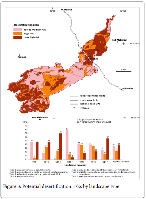
Figure 3: Potential desertification risks by landscape type
In the other hand, analysis of sensitivity to desertification risks, generated by socioeconomic and biophysical changes at the local scale, led to identify the most disturbing scenarios in terms of resource vulnerability in each landscape type (Figure 4). For the entire study area, the most disturbing scenario is the succession of four years of drought, which shows the sensitivity of the area to such climatic circumstances. The population growth presents also a significant effect on desertification risks in the study site. But, resource conservation projects, such as restrictions on pastoral and forest activities, can mitigate these desertification risks.
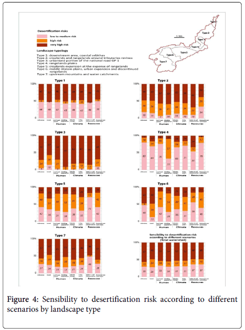
Figure 4: Sensibility to desertification risk according to different scenarios by landscape type
The analysis by landscape type shows differences in sensitivity to desertification according to the socioeconomic and biophysical potential changes. For example, the natural resources vulnerability in landscape n°1 (downstream of Oum Zessar watershed) is slightly more sensitive to climate changes than human actions, especially in the case of a succession of four drought years scenario, which can occur a high to very high risk of desertification on 58% of this landscape total area. The same finding concerns the landscape n°6, especially the very high risk occurred by the two climate changes scenarios. The natural resources vulnerability in the landscape n°5 presents a higher sensitivity to succession of four dry years.
The landscapes n°2, 4, 5 and 7 present a higher sensibility to Human actions. They are characterized by fragile soils and very steep slopes. The natural vegetation on these areas, although it is often scrubby and sparse, constitutes an important factor of temporary (or relative) stability of the soil. The excessive uses of this vegetation, combined with the physical characteristics cause the ablation of the soil and lead to water erosion. In the landscape 7 (mountains) for example, the high risk of degradation is explained by the type of land use (practice of check dams called Jessour) which is characterized by a high level of mechanical intervention. But in the majority of cases, the vulnerability is more sensible to doubling population scenario. The landscape 2 has the specificity that the natural resources could have very high risk of degradation if we follow the current water and soil conservation policy as scenario. This is because the localization of this landscape in the downstream, which will be less runoff if we multiply the number of water catchments in the upstream areas of Oum Zessar watershed.
The fight against desertification can be then more efficient if decision-makers recognize and adapt their actions and measures to local conditions. For example, in the case of sensitivity to human activities and practices in landscape 2 (mechanical intervention), the actions against desertification have to focus on restrictions of use of disc plows on fragile soils and not on multiplying for example water harvesting. The situation in the landscape 5 is different although we have the same level and type of risk as in landscape 2. In this case we have a different cause which is the population density. Then, the decision-makers should find a specific solution to this situation, such as applying a land consolidation project in this landscape to improve the productivity of lands and facilitate the access to credits. In the cases of sensitivity to climate changes (landscapes 1, 5 and 6), decision-makers can prioritize and focus to improve coping strategies in these areas (water harvesting techniques, soil conservation, etc.) instead of spending a lot of money in projects taking account of human action in these areas.
Conclusion
This research shows that desertification risk differs from one landscape to another, as well as the respective causes and driving forces. It gives alternatives to better understand desertification in order to better support decision-making and target actions to fight against this problem. The results show fighting against desertification can be more efficient if decision-makers recognize and adapt their actions and measures to local conditions. Multiple scenarios are applied using LEIS model (local environmental information system) in order to identify the levels of vulnerability of natural resources according to potential changes of socio-economic and biophysical factors, such as population growth and climate change.
The analyses of natural resources vulnerability show that affected areas (high to very high risk of desertification) represent 63% (22680 ha) of the total area of the study site. These affected areas from landscape type to another. Furthermore, analysis of sensitivity to desertification risks, generated by socioeconomic and biophysical changes at the local scale, led to identify the most disturbing scenarios in terms of resource vulnerability in each landscape type. For the entire study area, the most disturbing scenario is the succession of four years of drought.
The population growth presents also a significant effect on desertification risks in the study site. But, resource conservation projects, such as restrictions on pastoral and forest activities, can mitigate these desertification risks. The analysis by landscape type shows differences in sensitivity to desertification according to these socioeconomic and biophysical potential changes.
This work shows the role which can play the research to better understand the causes and consequences of desertification at the local scale in order to have a more efficient and adapted actions of fighting against this problem. It shows also the importance of integration of development actors in research approaches and methods. Additional co-constructed scenarios will be tested in the continuity of this work to have a better understanding and support of decision.
References
- Rubio JL, Andreu V (2009) Human and socioeconomic consequences of desertification. University of Las Palmas, Publications Services, Las Palmas. 342.
- Desjardins MR, Caron P (2005) The fight against desertification: a global environmental public good? Elements of response. Thematic folders of CSFD, Agropolis, Montpellier, France 32.
- Ouessar M, Tâamallah H, Begacem AO (2006) An environment with strong climatic constraints. In: Between desertification and development: Tunisian Jeffara, Cérès Editions, Tunisia 23-32.
- Hajjej MS, Khatra NB (2006) Articulation of the PANLCD (National Action Plan) monitoring and evaluation device with development process in Tunisia. In: Monitoring and evaluation of national action programs against desertification, Tunisia 93-119.
- Khatteli H (1996) Wind erosion in Tunisian arid and desert areas: process analysis and ways to fight. University of Ghent, Belgium 180.
- Souissi A (2000) Profile of Mediterranean countries. Tunisia: challenges and environmental and sustainable development policies, UNEP / Blue Plan, Sophia Antipolis, Tunisia 64.
- Auclair L (2001) Population and desertification in Tunisia in the twentieth century. In: Demographic and environmental regulations, CEPED Studies n°18, Research institute for development / French center on population and development / Population-Environment Laboratory, Paris 237-245.
- Cornet A (2002) The desertification at the intersection between environment and development: a problem that we concern. In: What issues? The contribution of scientists to debate, Johannesburg World Summit on Sustainable Development in 2002, Paris 91-130.
- Loireau M (1998) Space-Resources-Uses: spatialization dynamic interactions between social and ecological in Nigerian Sahel. University of Paul-Valéry Montpellier, Montpellier, France 411.
- ROSELT/OSS (2004) LEIS concepts and methods. Scientific document SD, ROSELT/OSS Collection, Montpellier 69
- Sghaier M, Ouessar M, De Laitre E, Leibovici D, Loireau M, et al. (2006) Integrated environmental and socio-economic modeling using LEIS for desertification monitoring and assessment in the observatory of MenzelHabib (South Tunisia). In: The Future of Drylands. International Science Conference on Desertification and Drylands research Tunis, Tunisia, 19-21 June 2006.
- Loireau M, Sghaier M, Fetoui M, Ba M, Abdelrazik M, et al. (2007) Local Environmental Information System (LEIS) for assessing desertification risk: circum-saharien compared situations (ROSELT network). Science and planetary changes / drought 18: 328-335.
- Fetoui M (2011) Assessing and monitoring desertification in Tunisian arid zones to help decision making: Climate-Human-Space-Resources, University of Paul-Valéry Montpellier.
- Ministry of Agriculture (2000) Exploitation/use state of deep aquifers in Governorate of Medenine, Tunisia. Annual report of Regional Direction of Water Resources 67.
- Tâamallah H, Ben Kehia H (2006) Geomorphology and soil characteristics. In: Between desertification and development, Ceres Editions, Tunisia 33-45.
- Le Treut H (2009) New climate on the earth - Understand, predict, react, Flammarion Editions, New Scientific Library 240.
- Dérioz P, Laques A-é (2004) Landscape assessment and territory diagnosis: from landscape evaluation to evaluation by landscape. Proceedings of the symposium "assessment of landscape, a necessary utopia? Publications of the University of Paul-Valéry, Montpellier 447-464.
- Luginbühl JY (1989) Elite and ordinary landscapes. French ethnology revue 3: 227-238.
- Krishan G, Kushwaha SPS, Velmurugan A (2009) Land degradation mapping in the upper catchment of river tons. J Indian Soc Remote Sens 37:119-128.
Citation: Fetoui M, Sghaier M, Loireau M and Chouikhi F (2015) Vulnerability of Natural Resources in Tunisian Arid Zones facing Climate Change and Human Pressure: Toward Better Target Actions to Combat Desertification. J Earth Sci Clim Change 6: 260. Doi: 10.4172/2157-7617.1000260
Copyright: © 2015 Fetoui M, et al. This is an open-access article distributed under the terms of the Creative Commons Attribution License, which permits unrestricted use, distribution, and reproduction in any medium, provided the original author and source are credited.
Share This Article
Open Access Journals
Article Tools
Article Usage
- Total views: 14843
- [From(publication date): 2-2015 - Apr 24, 2024]
- Breakdown by view type
- HTML page views: 10452
- PDF downloads: 4391