|
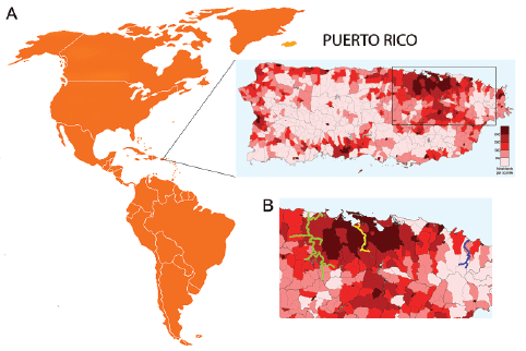
| Figure 1: A. Map of Puerto Rico, showing location within the Greater Antilles archipelago. Enlarged map shows population density within regional subdivisions of municipalities. Color legend indicates number of inhabitants per square mile, based on the 2000 US Census data. The darker the color, the more densely populated the area is (map was created by Javier Rodríguez Galarza, copyright holder of the work under Creative Commons Attribution 3.0 License). B. Closer view of area shown in the rectangle on map A, showing location of selected rivers. Blue, yellow, and green colored lines represent the selected rivers: blue – Mameyes (non-urban); yellow – Río Piedras (urban without a dam); green – La Plata (urban with a dam). |