Coastal Erosion and Shoreline Change in Ganjam Coast along East Coast of India
Received: 15-Mar-2018 / Accepted Date: 18-Mar-2018 / Published Date: 24-Apr-2018 DOI: 10.4172/2157-7617.1000467
Abstract
One of the rapidly changing coastal landforms is shoreline. It is very necessary to understand exact detection and frequent monitoring of shorelines through coastal processes and changing aspects of various coastal features. The present study is emphasized at investigating the shoreline changes along the Ganjam Coast, South Coast of Odisha by using geospatial techniques. The survey of India topographic maps and Landsat images were primarily used to extract shoreline features using software’s like Erdas Imagine and Arc GIS. The present study area is the Ganjam coast which is located on the south coast of Odisha which is from Prayagi to Bahuda river mouth. The beach has been eroded particularly in the Ramayapatam and Podampeta coastal tract due to various coastal processes that has taken place; such variations in the coastal processes are recorded by Landsat images and true colour image (Google earth) and also by repetitive field survey at different coastal sectors. The nature and magnitude of erosion indicates the immediate effect of waves attacking the coast under the impact of the low-pressure systems over the sea and the long-term impact of the loss of equilibrium between the waves and the coastline under the impact of the regimes of changing climate and sea level rise.
Keywords: Shoreline; Erosion; Accretion; Satellite images; Geographical Information System (GIS)
Introduction
Since beginning of time Coastal areas are very important for human beings. A coastal zone is the transition between the land and ocean. The environment of coast has been one of the major environmental concerns in many parts of the world. Besides natural processes that interface shoreline changes, human activities in the coastal zone add yet another dimension affecting changes to the coastlines. The coastline of India is undergoing changes due to various anthropogenic and natural interventions. These are highly dynamic area of interactions between terrestrial and marine processes. The process of erosion and sedimentation, periodic floods and cyclones and sea level changes continuously modify shoreline [1]. The changing costal configuration needs in depth understanding and investigation not only for preparing coastal zone management plans but also for the implementation of coastal regulations [2]. The rate of shoreline changes and its assessment for future prediction has a large environmental significance [3].
Literature Review
Recent studies of Mishra and Balaji [4] along the coastal area of South Gujarat, India, with multi-temporal satellite images of Landsat TM, ETM and OLI evaluated the historical shoreline changes. Their studies report that anthropogenic impacts are the foremost cause of shoreline erosion that has a serious environmental challenge to the Land-use/ land–cover along the coastline. Decadal shoreline assessment during 1990-2012, along the Odisha coast, India using remote sensing data (Landsat and IRS P6), has been reported by Murali et al. [5]. They mentioned that the shoreline has undergone severe erosion due to different degrees of combination of effects of sediment depletion, human intervention, sea level rise, and frequent floods and cyclones etc. Moreover, the Odisha coast exhibits severe erosion at many locations which demands their scientific management. All these studies signify the need for mapping shoreline configuration and its related factors. A recent study in Godavari delta by Hemamalini and Rao [6] has revealed that sustained erosion at the Godavari delta for the past two and a half decades claimed about 18.36 km2 of coastal land, leading to displacement of coastal communities and loss of mangrove vegetation. Apparently, decreased sediment supply through the river caused relative sea level rise under continued coastal subsidence along the delta front region. The extant conditions indicate that the problem may compound in future as more dams are coming up across the river. Many studies along Odisha coast have also revealed pronounced erosion at certain sections of the Mahanadi deltaic coast due to which even some villages were to be evacuated. In this background, it is essential to understand the magnitude of coastal erosion and land accretion at micro level. It is also important to assess the factors associated with this problem of this important delta along the east coast of this. The present study is such an attempt in this direction which aims to study and analyse the shoreline changes in terms of accretion, erosion using Toposheets, Landsat data, Google images and geospatial tools and techniques.
GIS techniques and Remote sensing have been widely engaged in various coastal morpho dynamic analysis as they are cost effective, reduce manual error and also helpful in the absence of field survey. The applications of remote sensing and GIS have proved particularly effective in demarcation of coastal morphology and coastal landforms detection of shoreline position. The location of shoreline and its historical rate of change can provide important information for design of coastal protection, plans for coastal development, the calibration and verification of numerical models etc. Studies of Naik and Rabindra along the south coast of Odisha demonstrated that the geomorphologic study of sand dunes with special reference to their hydrology in southern part of Odisha where they analyze the geomorphology, flora and hydrogeology of the coastal sand dunes and anthropogenic impact on sand dunes from a part of the south coast of Odisha. An attempt has been made to study and record the diverse coastal geomorphic features along Vishakhapatanam_Bhimunipatanam coast by Jagannathan et al. [7] analyzed remote sensing on coastal geomophological landforms from Coleroon river mouth to Cuddalore south Arcot, Tamilnadu. In this study they planned to develop an aerial photographs interpretation for geomophological investigation. A recent study in Godavari delta by Hemamalini and Rao [6] has revealed that sustained erosion at the Godavari delta for the past two and a half decades claimed about 18.36 km2 of coastal land, leading to displacement of coastal communities and loss of mangrove vegetation. Apparently, decreased sediment supply through the river caused relative sea level rise under continued coastal subsidence along the delta front region. The extant conditions indicate that the problem may compound in future as more dams are coming up across the river. Many studies along Odisha coast have also revealed pronounced erosion at certain sections of the Mahanadi deltaic coast due to which even some villages were to be evacuated. In this background, it is essential to understand the magnitude of coastal erosion and land accretion at micro level. It is also important to assess the factors associated with this problem of this important delta along the east coast of this.
Geographical and geological background of the Odisha Coast
Odisha has 480 km of coastline extending from the Andhra-Odisha boarder in the south up to the Orissa-West Bengal boarder in the north spreading over seven coastal districts. Along the coastline there lies the northern coastal plain between the Subarnarekha and the Dhamra river covering the districts of Baleswar and Bhadrak, the central delta region of the Mahanadi, Brahamani, and Baitarani spreading over the districts of Kendrapara, Jagatsinghpur and Puri and the narrow southern plains covering the coastal sections of the Khurda and Ganjam district. The Chilika Lake along the coast remains between the Puri and Ganjam plains spreading along the coast over an area of nearly 1100 km2 within the districts of Puri, Khurda and Ganjam. The geology of the Odisha Coastal Zone is characterised by the Quaternary Formations and Holocene sediments of fluvial, marine, brackish, lacustrine and Aeolian environment. The absence of Pleistocene rock exposure has been caused due to over lying of sediments during Holocene transgression [8]. The Holocene sediments are represented by greyish black, sticky plastic clay with fine silt and carbonaceous materials to the landward side along the coasts of Baleswar and Bhadrak districts. The sea shore side comprises of light yellow, fine to medium unconsolidated sand running parallel to the coast line along the deltaic coast and its southern section. The Oligocene and Lower Miocene deposits occur in the beds of the Budhabalanga River south of the Baripada town and Puri. These are mostly estuarine and marine sediments hidden beneath and are seen only in bore holes underlying the recent deltaic sediments. The rocks include a group of fossiliferous limestone, sand-stone and clays. Similar deposits have also been located in the “Samagara Pata” and “Sar Lake” area to the north or Puri town. Along the coast extensive sand deposits in the form of ridges have been developed by the strong S.W winds. The lagoon area is occupied with the deposits of clay and mud with varying proportion of sands. The rock samples from the bore holes had indicated that the basement topography is uneven with many ridges and basins below the deltaic alluvium. The presence of several fossiliferous limestone and fossil shells indicate the earlier existence of a marine environment much inland. More than 600 m thickness of sediments at Puri and other places reveal that the basin must be sinking with the deposition of sediments associated with faults giving rise to the coastal depressions [9]. The land ward side of the shore is occupied by the widespread palaeo-channels, natural levees, back swamps, lagoons and ancient beach ridges. These are characterized by parallel sets of lineaments and strand lines of varied tonal contrast over the satellite imageries.
The littoral zone of the Odisha coast extends for about 5 km to 10 km inland from the shore. It is a zone of braided, sluggish and brackish streams, tidal creeks, sand ridges and dunes, back swamps and mud flats. This zone is often called as the “Salt Tract” [10]. The deltaic and riverine plains of older and younger alluvium follow this zone inwards which varies from 50 to 100 km. Major rivers of Odisha originating from and beyond the Eastern Ghats drain to the Bay of Bengal through this coastal tract. The combined delta of the Mahanadi-Brahmani-Baitarani Rivers extending over nearly 10,000 km2 area is the most prominent depositional feature of the Odisha coast. This zone merges westward with the submontane tract of the Eastern Ghats. But longitudinally the coastal zone by and large consists of a micro-tidal region from the Andhra boarder up to the mouth of the river Devi, a meso-tidal zone from the Devi mouth up to the Dhamra mouth and a Macro-tidal zone from the Dhamra mouth up to the Subarnarekha mouth in the north along Baleswar coast [11-15].
The Ganjam Coast and its geomorphical background
The study area forms a part of the southeast coast of India in the Ganjam coast of Odisha from latitude 19027’ 53.90°N and 190 4’ 39.45° N and longitude 84010’ 32.79° E to 840 10’ 46.2.41° E and covered by parts of survey of India topographical sheet No. 74E3, 74A15, 74A12, 74A16. It includes the Ganjam coastal region including Prayagi, Kalarabadi, Anantraypur, Sunapurapeta, Katuru, Ramayapatanam, Markandi, Gopalpur, Bandara, Aryapalli etc. The study area is surrounding in the south Odisha coast in the south by Bay of Bengal. Bahuda and Rushikulya are two major rivers of study area. The coast line of the area is almost straight with an overall concavity towards the sea (Figure 1).
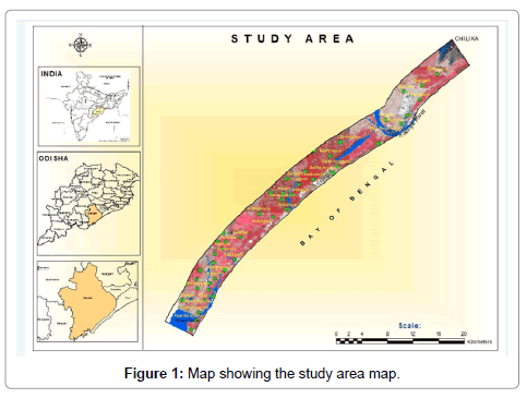
Figure 1: Map showing the study area map.
The Ganjam coast area is characterised by an equable temperature all through the year, particularly in the coastal regions and by high humidity. The cold season from December to February is followed by hot season from March to May. The period from June to September marks the southwest monsoon and 70% of annual precipitation is received during this period. The normal rainfall of this district is 1444 mm. May is the hottest month with the arrival of the monsoon by about the second week of June the day temperature decreases slightly while the night temperature continues as it was in the summer. Towards the end of September after the withdrawal of south west monsoon, temperature decreases progressively. December is the coldest month. The relative humidity is high throughout the year especially in coastal areas. Winds are fairly strong particularly in coastal region in summer and monsoon months (Ganjam.nic.in). The Eastern Ghats super group comprising Khondalite and Charnockite suites of rocks from the basement of the study area.
Shore processes and shoreline changes
Morphological evolution and change of the coastline along with its erosion and land accretion in a deltaic region depend on its geologic, tectonic, geographic, climatic and environmental settings. Evolution of the shoreline and its associated landforms in the Mahanadi delta front bear ample evidence to the combined action of the waves, currents, tides, coastal wind and storm surges as well as the episodic actions of the floods and cyclones. The offshore features point to the dominant action of the waves followed by offshore long currents (littoral drift) and the coastal wind. The backshore features are mostly linked to the tidal actions, shore wind and flood flow in the rivers as well as the estuarine interaction of sweet and saline water and sorting of sediments. The occasional high flood flows; large tidal waves and storm surges have also a significant bearing on the morphological changes of the shoreline and offshore landforms. The protruding deltaic lobes of the study area relates to the deltaic regime, abundance of sediments from the rivers, tide and littoral drift along the coast.
Wind, wave and littoral drift
Odisha coast is in general, oblique to the prevailing winds and waves that generate strong northerly littoral currents. Along shore sediment transport in Odisha compares to the highest transport rates in the world, within the order of one million cubic meters to the north at Paradeep. Their study revealed that the predominant wave directions are from the south or southwest. The bulk of the waves attain a height of less than 1.25 m and a period of less than 7 seconds. During the storms, however, waves reach 7 to 8 m. in height as it was observed during 1999 super cyclone. The oblique waves carry sediments from the breaker zone and beach to an offshore position to develop the barrier beaches, bars and islands. The littoral drift picks up the river discharged sediments deflecting it towards the northeast. The development of the spits and bars confirm to the evidence that the littoral drift supply materials but their evolutionary process can be thought of as a result of spasmodic progradation by obliquely impinging waves at the time of major storms or depressions. The windblown sand brings sand deposition on the barrier bars and spits. Besides deposition there has also been erosion along the shore, on the seaward side of the spits and islands. The littoral drift plays a significant role in chocking the river mouth with the deposition of sediments as bay mouth bars or islands in the pre and post monsoon season when the volume of water discharge of the river is low [16,17].
Tropical cyclones along Odisha Coast
The India Meteorological Department (IMD) data for the period 1891 to 2007 has been analysed by Chandrasekhar Bahinipati and it has been seen that 48.19% of the total number of cyclones (i.e., 387 out of 803 cyclones that hit the eastern coastal states) occurred in Odisha. Severe flooding caused by storm surges during 1999 super cyclone; known as 05B, Phailin 2013 etc. caused massive destruction to life and property. These are the prime reason of changes along the coast.
Data and Methodology
Data sources
Survey of India topographic sheets during 1972-1973 and Landsat images from October 2016 (path 140 and row 47) and Google earth images are used for the study.
Data processing
Identification of areas of coastal erosion and Accretion based on Indian topographical maps for 1972 in scale 1:50000 and Landsat image of 2016. Shoreline maps drawn from topographic sheets were scanned and base maps were generated for the year 1972-1973. We manually digitized the shorelines as line features from topographical maps of year 1972. They are further digitized and registered by giving corner points after projection with projected coordinate systems of UTM WGS 84 and from the co-registered Landsat satellite images of year 2016 (Table 1). The erosion along the coast is identified through vector overlay analysis of the above outputs. With limited field check, we delineated the location of erosion points. Due to inaccessibility to the high-resolution satellite or areal data, we demarcated the location of erosion points over the Google earth images with limited field verification. For that, Google earth image were download and geo-referenced through topographical maps given with coordinates points in UTM WGS-84. (RMS Error attached, Annexure-I)). Accuracy of geo-correction data is tested by swiping one data above other data and successive confirmation from the field check. Shorelines are digitized as line features from Landsat images. Shorelines representing different years of a same station are presented by overlying together. Quantification of erosion and accretion rate is done by digitisation as polygon features using Arc GIS software. Subsequently, we would plan to extend this work for large scale analysis with the procurement of high resolution imagery.
| Band Reference Number Centre (nm)1 | Band Description | Band centre |
|---|---|---|
| 1 | Costal Aerosol (Operational Land image (OLI) | 433 |
| 2 | Blue (OLI) | 482 |
| 3 | Green (OLI) | 562 |
| 4 | Red (OLI) | 655 |
| 5 | Near Infrared (OLI) | 865 |
| 6 | Short wavelength Infrared (SWIR-1) | 1610 |
| 7 | SWIR-2 (OLI) | 2200 |
Table 1: Band identification of Landsat image (2016).
Results and Discussion
Ganjam Coast
The length of Ganjam coast is 61 km. It has been observed that (Figure 2), during 1972 to 2016 the coast shows considerable erosion of around 5 km2 and accretion of around 1.6 km2. During this period erosion has occurred along the shoreline from the Soradapur to Purunabandha in the north, Nolianuagaon to Barhaputi and Bakshipalli to PaddaLakshmipur as same as Accretion has occurred near Purunabandha to Nolianuagaon and Barhaputi to Gopalpur. It is also observed that Bahuda river mouth has sifted nearly 2 km towards north near Katuru (Figure 3). In the other hand Rushikulya River mouth (near Gokharkuda) has sifted nearly 1.5 km towards south (Palibandha) (Figure 4).
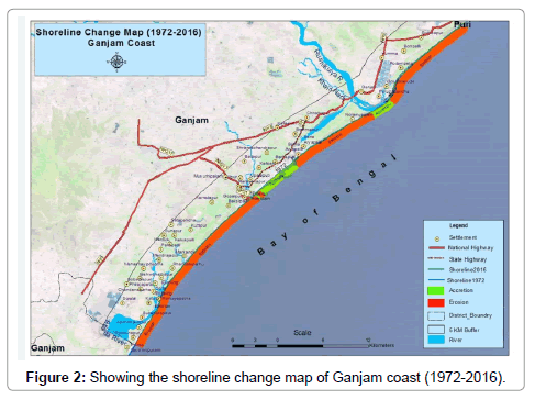
Figure 2: Showing the shoreline change map of Ganjam coast (1972-2016).
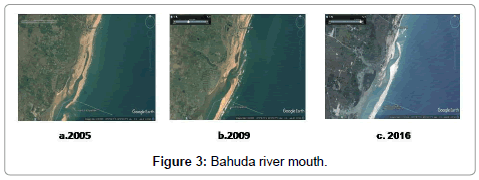
Figure 3: Bahuda river mouth.
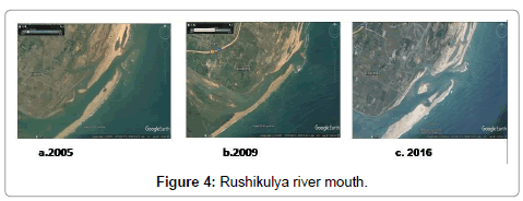
Figure 4: Rushikulya river mouth.
Ramayapatnam: It is also observed that near Ramayapatnam in 2005, the distance from shoreline from Road is 163 m whereas in 2009 its decreases 125m and 78 m. in 2016. The study indicates that coast line is sifted 85 m towards landside during last 44 years (Figures 5-7 and Table 2)
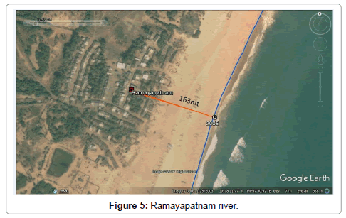
Figure 5: Ramayapatnam river.
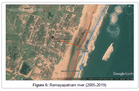
Figure 6: Ramayapatnam river (2005-2019).
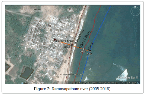
Figure 7: Ramayapatnam river (2005-2016).
Podampeta: It is also observed that near Podampeta in 2005, the distance from shoreline from Road is 211 m whereas in 2009 its decreases 130 m and 91 m in 2016. The study indicates that coast line is sifted 120 m towards landside during last 44 years (Figures 8-10 and Table 2).
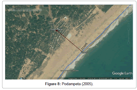
Figure 8: Podampeta (2005).
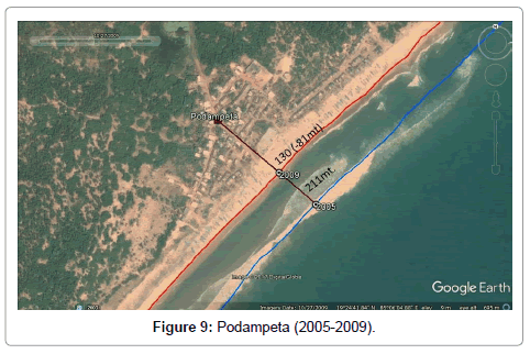
Figure 9: Podampeta (2005-2009).
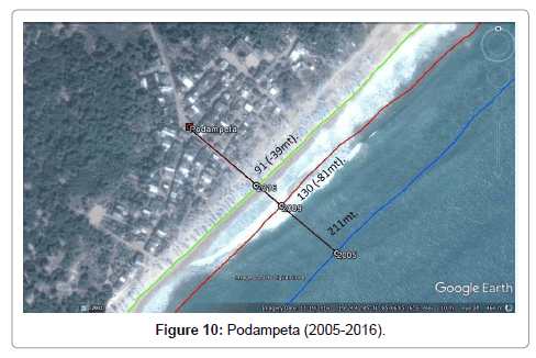
Figure 10: Podampeta (2005-2016).
| Erosion at different locations in the stretches across Ganjam Coast | |||||
|---|---|---|---|---|---|
| Location | Coastal length (in meter) | Change 2005-2016 (in meter) | Coastal Process | ||
| Year-2005 | Year-2009 | Year-2016 | |||
| Ramayapatnam | 163 | 125 | 78 | 85 | Erosion |
| Podampeta | 211 | 130 | 91 | 120 | Erosion |
Table 2: Erosion at different locations in the stretches across Ganjam Coast.
If the sediment supply through the river is diminished leads to relative sea level rise causing erosion along the coast. A number of studies from India and abroad on deltas had indicated that construction of dams affects the sediment influx, thereby leading to coastal erosion as in the case of Godavari delta. Some studies have also suggested neotectonic activity as a cause for coastal erosion along the delta front. The starvation of sediments at the river mouths and coastal areas may have been the cause for coastal erosion at selected locations. But however, the magnitude of coastal erosion at several locations along the deltaic coast in the recent times points towards causes other than the preceding causes. Recently occurring coastal erosion south of Konark and Puri and in south Odisha at Podampetta and Gopalpur of Ganjam district is indicative of a set of different causes and factors with a focus on changed climatic regime over sea during development of low pressure systems.
Conclusion
This study investigates the coastal erosion and accretion on the part of Ganjam Coast. During this period erosion has occurred along the shoreline from the Soradapur to Purunabandha in the north, Nolianuagaon to Barhaputi and Bakshipalli to Padda Lakshmipur as same as accretion has occurred near Purunabandha to Nolianuagaon and Barhaputi to Gopalpur covering a period of 44 years. The erosion observed is not continuous all along the coast but in isolated stretches along the coast. Comparatively large erosion has been observed at Ramayapatanam and Podampetta whereas accretion has been observed near Palibandha i.e., near 0.156 km2. The coast line at Gopalpur is stable with negligible erosion and accretion. Significantly amount of loss of land is observed mainly at the river mouth due to the sediment erosion from the banks because of complex interactions between river flow, waves and the tides. Overall, during the study periods, erosion activities are high compare to accretion in study area. Result from historical shoreline change analysis conducted along the Ganjam coast, it is demonstrated that the storm surge and the constant pounding nature of the wave can cause serious damage to coastal structures. It can also cause severe coastal erosion as the wave erode sand from beaches, dunes, weaken coastal cliffs and damage the shoreline. The India Meteorological Department (IMD) data for the period 1891 to 2007 has been analyzed by Chandrasekhar Bahinipati and it has been seen that 48.19% of the total no. of cyclones (i.e., 387 out of 803 cyclones that hit the eastern coastal states) occurred in Odisha. Severe flooding caused by storm surges during 1999 super cyclone; known as 05B, Phailin caused massive destruction to life and property. These are the prime reason of changes along the coast (Table 3). The maps as well as the results of the analysis may be used as planning tools for local level protecting and managing the resources in the study area.
| Year | Location | Disaster types | disaster sub-types | Name |
|---|---|---|---|---|
| 1978 | Odisha | Storm | Tropical Cyclone | Not Available |
| 1978 | Odisha | Storm | Tropical Cyclone | Not Available |
| 1981 | Odisha | Storm | Convective Storm | Not Available |
| 1981 | Odisha | Storm | Tropical Cyclone | Not Available |
| 1982 | Odisha | Storm | Tropical Cyclone | Not Available |
| 1983 | Odisha | Storm | Tropical Cyclone | Not Available |
| 1989 | Odisha | Storm | Tropical Cyclone | Not Available |
| 1995 | Odisha | Storm | Tropical Cyclone | Not Available |
| 18.10.1999 | (Odisha) Ganjam,Puri,Khajapati | Storm | Tropical Cyclone | Not Available |
| 28.10.1999 | (Odisha) Kendrapara, Jagatsinghpur, Cuttack, Nayagarh, Bhadrak, Keonjhar, Dhenkanal, Balesore, Mayurbhanj, Jajpur. | Storm | Tropical Cyclone | Super cyclone (05B) |
| 2002 | Odisha | Storm | Convective Cyclone | Not Available |
| 2009 | Kendrapara,Odisha | Storm | Convective Cyclone | |
| 2013 | Odisha | Storm | Tropical Cyclone | Phailin |
| 2014 | Ganjam,Odisha | Storm | Tropical Cyclone | Hudhud |
Table 3: Decade-wise frequency of cyclones in Odisha during 1971-2014. (Source: Em-dat_ The International Disaster Database).
References
- Vinayaraj P, Johnson G, Dora GU, Philip CS, Kumar VS (2011) Quantitative estimation of coastal changes along selected locations of Karnataka, India: A GIS and remote sensing approach. International Journal of Geosciences 2: 385-393.
- Chen S, Chen L, Liy Q, Li X, Tan Q (2005) Remote sensing and GIS based integrated analysis of coastal changes and their environmental impacts in Ling ding bay ocean and coastal management. Journal of ocean and coastal management.48: 65-83.
- Mishra A, Balaji R (2015) A study on the shoreline changes and land-use/land-cover along the South Gujarat Coastline. 8th International Conference on Asian and Pacific Coasts 116: 381-389.
- Murali RM, Dhiman R, Choudhary R, Seelam JK, Ilangovan D, et al. (2015) Decadal shoreline assessment using remote sensing along the central Odisha coast. Environmental Earth Sciences 74: 7201-7213.
- Hemamalini B, Rao NK (2004) Coastal erosion and habitat loss along the Godavri delta front- A fallout of dam construction. Current Science 87: 1232-1236.
- Jagannathan CR, Ratnam C, Baishya NC, Gupta DU (1983) Geology of the offshore Mahanadi Basin. Asia J 6: 101-104
- Meijerink AMJ (1983) Dynamic geomorphology of the Mahanadi Delta. ITC Journal 243-250.
- Mahalik NK (2000) Mahanadi delta: Geology resources and biodiversity. AIT Alumini 169.
- Mahalik NK, Das C, Maejima W (1996) Geomorphology and evolution of Mahanadi Delta. Journal of Geoscince 39: 111-122.
- Aleshikh AA, Ghorbanali A, Naouri N (2007) Coastline change detection using remote sensing. International Journal of Environmental Science & Technology 4: 61-66.
- Boutiba M, Bouakline S (2011) Monitoring shoreline changes using digital aerial photographs, quick-bird image and DGPS topographic survey: Case of the east coast of Algiers. European Journal of Scientific Research 48: 361-369.
- ChenthamilSevan S, Kankara RS, Rajan B (2014) Assessment of shoreline changes along Karnataka coast, India using GIS & Remote sensing techniques. Indian Journal of Marine Sciences 43: 1-7.
- Kumaravel S, Ramkumar T, Gurunanam B, Suresh M, Dharanirajan K (2013) An application of remote sensing and GIS based shoreline change studies-A case study in the Cuddalore District, East Coast of Tamilnadu, South India. International Journal of Innovative Technology and Exploring Engineering 2: 211-215.
- Mohanti M (1990) Sea level rise: Background, Global concern and implications for Orissa Coast In: Sea level variation and its impact on coastal environment. Tamil University Publication No. 131: 197 232
- Nayak SR (2002) Use of satellite data in coastal Mapping. Indian Cartographer 22: 147-157
- Rajawat AS, Gupta M, Pradhan Y, Nayak S (2005) Coastal processes along the Indian coast - Case studies based on synergistic use of IRS-P4 OCM and IRS-1C/1D data. Indian Journal of Marine Science 34: 459-472.
Citation: Monalisha M, Panda GK (2018) Coastal Erosion and Shoreline Change in Ganjam Coast along East Coast of India . J Earth Sci Clim Change 9: 467. DOI: 10.4172/2157-7617.1000467
Copyright: © 2018 Monalisha M, et al. This is an open-access article distributed under the terms of the Creative Commons Attribution License, which permits unrestricted use, distribution, and reproduction in any medium, provided the original author and source are credited.
Share This Article
Open Access Journals
Article Tools
Article Usage
- Total views: 6642
- [From(publication date): 0-2018 - Apr 25, 2024]
- Breakdown by view type
- HTML page views: 5696
- PDF downloads: 946