| Research Article |
Open Access |
|
| Priya KL1*, Nalini Jebastina1 and Prince Arulraj G2 |
| 1Assistant Professor, School of Civil Engg, Karunya University, Coimbatore 641114, India |
| 2Director, School of Civil Engg, Karunya University, Coimbatore 641114, India |
| *Corresponding authors: |
Priya KL
Assistant Professor, School of Civil Engg
Karunya University, Coimbatore 641114, India
Tel: 04222614450
Fax: 91 422 2615615
E-mail: piya_kl@yahoo.co.in |
|
| |
| Received November 09, 2011; Published July 28, 2012 |
| |
| Citation: Priya KL, Jebastina N, Prince Arulraj G (2012) Assessment of Water Quality Indices for Groundwater in the Singanallur Sub-Basin, Coimbatore, India. 1: 186. doi:10.4172/scientificreports.186 |
| |
| Copyright: © 2012 Priya KL, et al. This is an open-access article distributed under the terms of the Creative Commons Attribution License, which permits unrestricted use, distribution, and reproduction in any medium, provided the original author and source are credited. |
| |
| Abstract |
| |
| Groundwater quality of Coimbatore city needs greater attention because it is the alternative source of water for domestic and agricultural purposes. The problem relating to groundwater is not restricted to Coimbatore, but in many regions of the world. The present study was attempted to access the groundwater quality of Singanallur in Coimbatore. The technology adopted combines field investigations and GIS (Geographical Information System) [1]. Water Quality Index, has been calculated for the Singanallur sub-basin and the entire sub-basin was zoned to study the suitability of water for drinking purposes using the software ArcGIS and the results showed that the ground water quality was unfit for drinking in some of the areas scoring a water quality index greater than 100. The least water quality index of 51 was scored by Lakshmipuram from where the water can be used for domestic purposes. |
| |
| Keywords |
| |
| Groundwater monitoring; Water quality index; GIS; WHO/BIS/ICMR standards; India |
| |
| Introduction |
| |
| For the past few decades, there has been an acute demand for water resources. Industrial growth, population growth, and other developmental activities have resulted not only in a high demand for water, but also in the degradation of quality, which aggravated the water crisis. Water pollution is a growing hazard in many developing countries including India. A polluted environment has a detrimental effect on the health of people, animal life and vegetation [2]. Groundwater is an important source for domestic, agricultural and industrial use. Due to this fact, it becomes essential for continuous monitoring of the quality of groundwater so that ground water pollution can be minimized by preventing unscientific practices. |
| |
| There are different ways for accessing water quality, one of which is the Water quality Index (WQI) [3]. WQI is an efficient tool on communicating the overall quality of water [1]. GIS (Geographical Information System) is an effective tool in decision making for managing spatial and attribute data. GIS has wide application in water quality mapping using which informative and user-friendly maps can be obtained. The present study was aimed to obtain a decision support system for the sub-basin by integrating WQI and ArcGIS. |
| |
| Coimbatore city, called as the Manchester of India is situated on the banks of river Noyyal, a part of Cauvery basin. Of the various tanks fed by Noyyal river, Singanallur tank is one of the biggest and the most polluted tanks. The Singanallur sub-basin has been selected for the present study. The hydrogeological studies revealed that the formation of the strata is of consolidated type, fissured zones and the age group of Pre-cambrian group. The lithological characteristics include gneiss and other basic intrusives. The ground water is restricted to a depth of around upto 20 m in the study area. The water table is at a depth of 400 m above Mean Sea Level. The aquifer of the area is discontinuous with secondary intergranular porosity and fractures. (Central Ground Water Board) [4]. |
| |
| Materials and Methods |
| |
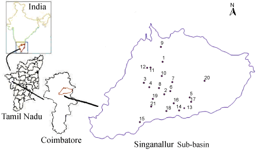
| Survey of India (SOI) toposheets on 1:50,000 scales were used to prepare the base map of the study area. The toposheets were scanned and digitized using ArcGIS software in order to obtain the baseline data. The sub-basin of the tank was prepared from the contour and drainage map using AUTOCAD 2007. Twenty one sampling locations were identified from the study area for the purpose of mapping the ground water quality [5] (Figure 1). Water samples (Table 1) were collected from open and bore wells, Singanallur tank and Noyyal river during the month of March 2009 and were analysed for various physiochemical per American Public Health Association (APHA) [6] standard methods. A hand held GPS was used to obtain the latitude and longitude of the sampling stations. |
| |
|
|
Figure 1: Sampling Locations. |
|
| |
|
|
Table 1: Details of Sampling Stations. |
|
| |
| Results and Discussion |
| |
| The water quality indices were calculated to determine the suitability of water for drinking purposes form the analysis results (Table 3). The pH was slightly alkaline in all stations except in Periyathottam and Nathamedu thoppu. It was within the permissible limit as per BIS standards [5]. The chlorides contents were high in all areas except in Lakshmipuram. The quality of water from Lakshmipuram was better compared to other stations and hence it scored the best. Total Dissolved solids varied from 400 mg/l in Lakshmipuram to 6400 mg/l in Kasturinagar thottam showing a high variation. Total hardness, Ca and Mg hardness were found to be high in Uppilipalayam, Tank (West), Vellarlore, LC road, Kasturinagar thottam, Rajiv Nagar, Periyathottam, Asokanagar, LG Vellalore, Kamachiamman Kovil, Vivekananda nagar and Nathamedu thoppu [7]. The high amount of chlorides, TDS and hardness is due to the geological formation of the area. The minerals of the soil and rock get dissolve in the ground water leading to high concentrations of dissolved solids. The area mainly consists of residential and agricultural land. The contaminants get added up due to unscientific practices of agriculture and letting of sewage into water bodies without treatment. The surface water ie. tank and river has slightly high hardness and chlorides due to the presence of domestic sewage. The domestic sewage was discharged at the northern side of the tank and there was a site for the disposal of solid waste. Alkalinity varied between 200 mg/l to 830 mg/l, the minimum being at Lakshmipuram. The alkalinity was mainly due to bicarbonates, while carbonate alkalinity was found to be zero. Sulphates was less in many areas except in Uppilipalayam, Rajiv Nagar, and Asokanagar. The Ca and Mg hardness in many places show high values which indicate that the soil is high in Calcium chloride and Magnesium chloride. The tank water and river water showed low DO due to the presence of domestic sewage. The Noyyal river was filled with domestic sewage near the tank area. The tank had a flow from the North towards South. There was an inlet of domestic sewage near the station point 6 (Tank North), resulting in a very low DO of 0.2 mg/l. As the water flowed from point 6 to station point 17 (Tank South), there was a marginal increase in DO due to the self purification of the water. On the southern part of the tank, the area is made extensively of agricultural land. The unscientific agricultural practices adopted by the farmers resulted in the leachate of chemicals to ground water thereby polluting ground water. |
| |
|
|
Table 2: Classification of Water based on WQI. |
|
| |
|
|
Table 3: Water Quality Indices. |
|
| |
| The water quality indices were calculated to determine the suitability of water for drinking purposes. For the locations, Uppilipalayam, tank (North), Tank (West) and Tank (South), WQI is greater than 100 and hence unfit for drinking. The water quality index map showed that the sampling stations Lakshmipuram, Periyathottam, LG Vellalore, Vivekanandanagar and Nathamedu thoppu came into the category of 3 which indicates that water is moderately suitable for drinking. However, this water can be used for domestic purposes like flushing, washing etc. The water may be used for drinking if necessary, after filtration and boiling. The quality of samples Vellalore road, Kasturinagar thottam, Rajiv Nagar was very poor. |
| |
| From the WQI map (Figure 2), it is evident that the areas on the southern part of the tank fall into the category of very poor quality, due to the leachate from agricultural land as mentioned before. The tank water having less DO, due to the discharge of domestic sewage, obtained a quality rating as unfit for drinking. The Noyyal river water falls under the category of very poor. |
| |
| |
| Conclusions |
| |
| The WQI map prepared for the study area can be used as a tool for decision making, regarding the usage of water for drinking and other domestic purposes. Proper sewerage system followed by an effluent treatment plant; collection, treatment and disposal of solid waste by the municipality; usage of biofertilizers are some of the methods to be developed to safeguard the quality of surface and ground water of Coimbatore city. The method adopted can be implemented in other areas having similar water related problems so that water pollution can be prevented, thereby opening a way to face the water crisis of the whole world. |
| |
| Acknowledgement |
| |
| The authors would like to express their gratitude for the financial support given by the Karunya University through seed money for carrying out the research work. |
| |
| |
| References |
| |
- Asadi S S, Padmaja V, Anji M R (2007) Remote Sensing and GIS Techniques for Evaluation of Groundwater Quality in Municipal Corporation of Hyderabad (Zone-V), India. Int. J. Environ. Res. Public Health 4: 45-52.
- Sujatha, Reddy R.B (2003) Quality characterization of ground water in the south-eastern part of the Ranga Reddy district, AP. Indian Journal of Geology 44: 579-558.
- Dwivedi S.L, Vandna P (2007) A Preliminary Assignment of Water Quality Index to Mandakini River, Chitrakoot. IJEP 27: 1036-1038.
- BIS: 10500, 1991 Specifications for drinking water, Indian Standard Institutions (Indian Bureau of Standards), New Delhi.
- Ramakrishnaiah CR, Sadashivaiah C, Ranganna G (2009) Assessment of Water Quality Index for the Groundwater in Tumkur Taluk, Karnataka State, India. E-Journal of Chemistry 6: 523-530.
- Americal Public Health Association, (APHA), 1998. Standard Methods for the examination of water and waste water, 18th edition. MWWA&WPCF, Washington.
- Mishra BB, Chaturvedi GB, Tewari DD (2008) Water Quality Index and suitability of water of Kohargaddi dam at district Balrampur, India. Poll Res 27: 497-500.
|
| |
| |