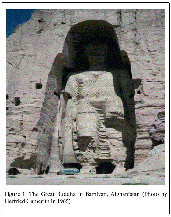
The Great Buddha in Bamiyan, Afghanistan 40th Anniversary of its Stereo- Photogrammetric Documentation
Received: 12-Feb-2014 / Accepted Date: 14-Mar-2014 / Published Date: 20-Mar-2014 DOI: 10.4172/2168-9717.1000122
74370Introduction
The region of Bamiyan, around two hundred kilometre north-west of Asian country national capital, Afghanistan, was one in all the foremost Buddhist centres from the ordinal century ad up to the time once Islam entered the world within the eighth century [1]. For hundreds of years, Bamiyan lay at the guts of the renowned trade route, providing rest to caravans carrying product across the world between China and Western empires. Strategically set in a very central location for travellers from north to south and east to west, the village of Bamiyan was a typical facility for several ancient cultures.
Following a scientific expedition to the High Hindu Kush, on 30 August 1970 the team of Robert Kostka, David Braslau and Walter Kuschel, successfully captured detailed 3-dimensional geometry of the Great Buddha in Bamiyan, Afghanistan using stereo-photogrammetry [2].
The colours of this extraordinary valley with its cliff of rhubarb red, its indigo peaks roofed in glittering snow and its new-sprung corn of harsh electric green, shone doubly brilliant in the clear mountain air. And there suddenly, like an enormous wasps’ nest, hung the myriad caves of the Buddhist monks, clustered about the two giant Buddhas [3].
The documentation from that study was published in 1974 as a paper entitled “Stereo Photogrammetric Imaging of the Great Buddha in Bamiyan” in the international Afghanistan Journal by the Academic Printing and Publishing House in Graz (Dr. Karl Gratzl). The report contains several figures, including a detailed vertical contour map of the Buddha statue with 20 centimeter contour intervals.
In March 2001, when the Great Buddha statue was destroyed, it became the target of worldwide interest. Only after the destruction of the statue did the World Heritage Committee of UNESCO decide to include the cultural landscape and archaeological remains of the Bamiyan Valley in the list of World Heritage Sites [4,5].
In 2004, thirty years after publication of the report, the original photogrammetric images were donated to the Bibliotheca Afghanica in Switzerland, where they were further processed by Professor Armin Grün at the ETH Zurich. Based on his work, a 2.5-meter high and 700 kg model of the Buddha was created, and exhibited in Japan in the summer of 2005 in the Swiss Pavilion at the World Exhibition EXPO 2005 in Aichi [6]. In addition, an award-winning film about the fate of the large Buddha statues “The Giant Buddhas” was produced by the Swiss filmmaker Christian Frei.
In the spring of 2014 on the occasion of the 40th anniversary of the first publication of the paper, it was scanned and placed on the website [7] of the Institute of Remote Sensing and Photogrammetry, Graz University of Technology. The quality of the Buddha statues can no longer be argued about, because they are gone.
With this, results of the study are made available through open access to a much larger audience. (Figure 1)
The Bamiyan Buddha was created by cutting a high-relief figure into the face of the soft conglomerate cliff. It is possible that the niche was carved out first, using scaffolding slotted into holes cut into the cliff, before the ambulatory galleries were carved; the scaffolding later being replaced by a series of permanent wooden ladders, landings and facades. The torso was roughly shaped and detailing of the folds of the gown was built out by cutting lines of shallow holes for wooden pegs on which were hung ropes coated with thick stucco.
The additional photo by Herfried Gamerith from the year 1965 will provide the possibility for comparing the height and condition of the Buddha as it was in 1965.
For the surface reconstruction, due to the scale and rotation differences among the images, the modified version of the developed MPGC matching algorithm was applied.
References
- Armin G, Fabio R, Li Z (2004) Photogrammetric reconstruction of the Great Buddha ofBamiyan, Afghanistan. The Photogrammetric Record 19: 177-199.
- Green A, Dino RF (2005) The Return of the Buddha- Photogrammetry and cultural heritage in Bamiyan, Afghanistan. PhotogrammetryRemote Sensing Geo Part I: 1: 57-68.
- Kostka R (2011) Wakhan Talschaft zwischen Pamir und Hindukush; Roger Senarclens de Grancy (1938-2001);internationales Gedächtnis-Symposium 2011; 50 Jahre Erkundungs- undForschungsarbeiten an der Technischen Universität Graz. Graz Verl. Der TU.
Citation: Kostka R, Braslau D, Minneapolis, Kuschel W (2014) The Great Buddha in Bamiyan, Afghanistan 40th Anniversary of its Stereo-Photogrammetric Documentation. J Archit Eng Tech 3: 122. DOI: 10.4172/2168-9717.1000122
Copyright: ©2014 Kostka R, et al. This is an open-access article distributed under the terms of the Creative Commons Attribution License, which permits unrestricted use, distribution, and reproduction in any medium, provided the original author and source are credited.
Select your language of interest to view the total content in your interested language
Share This Article
Recommended Journals
Open Access Journals
Article Tools
Article Usage
- Total views: 15366
- [From(publication date): 6-2014 - Aug 29, 2025]
- Breakdown by view type
- HTML page views: 10744
- PDF downloads: 4622

