Agro Climatic Characterization in the Selected Woredas of Western Oromia, Ethiopia
Received: 14-Dec-2017 / Accepted Date: 05-Mar-2018 / Published Date: 09-Mar-2018 DOI: 10.4172/2157-7617.1000455
Abstract
Agro-climatic characterization of western Oromia was performed using indigenous knowledge and historical meteorological data indices in a statistical software. Rainfall and temperature of selected meteorological stations representing different Agro-ecological zones (lowland, midland and highland) of western Oromia were analyzed on annual, seasonal and monthly time scales using long period data. Quantitative data were analyzed through SPSS and qualitative data through content analysis. Instant Statistical Packages for Agro-climatological data was used in analyzing the 30 years meteorological data of western Oromia meteorological stations. This study looks at growing season dates in terms of dry spell lengths, onset, cessation and length of growing season among others using INSTAT software. The spatial distributions of different annual and seasonal rainfall variables were mapped. A survey research design was used, and data collected through focus group discussions, questionnaires and key informant interviews. Simple random and purposive sampling methods were used, where 210 small scale farmers and 30 key informants from western Oromia participated. The study conducted surveys of 210 households in the selected woredas of Western Oromia to characterize the agro climate of smallholder farmers. Rainfall, minimum temperature and maximum temperature data of western Oromia (1980-2014) were analyzed to assess agro-climatic characterization and climatic trend of the area. The rainfall and temperature data over the western Oromia are analyzed on an annual basis using historical datasets. Over western Oromia, the observed average total annual rainfall showed a significant decreasing trend (43.67 mm per decade) in the last 30 years analysis period, with a relatively large inter-annual variability, while the maximum, mean and minimum temperatures have increased at a rate of 0.22°C and 0.21 8°C per decade, respectively. The study revealed that most significant change has been unpredictable rains (60.48%), very hot season (20.95%) and prolonged drought (14.29%). The historical climate results across the selected stations shown that a late start has an early end of rainfall hence a short growing season observed. Farmers’ perceived late on set of rain, poor distribution within the season, and sometimes early cessation. Local community perceived the onset date of Kiremt (Ganna) rainfall of study area was on the first week of May and the cessation date of Kiremt rainfall starting from the last week of November over the last 20 years. But, the historical climate results show the onset date of the growing season was in the early June and the cessation date of Kiremt rainfall on the mid October. Therefore, Knowledge on the date of onset and cessation rains and length of growing period (LGP) will help to plan the agricultural operations better, particularly, land preparation and sowing.
Keywords: Agro climate; Characterization; Indigenous knowledge; Growing season; Historical climate
Introduction
Agriculture is the back bone in the Ethiopia economic development. Agricultural activities are totally dependent on weather and climate that will have a serious implication on the food security efforts which is currently strained by the ever-increasing human population and increased demand and the growth of natural resources use [1]. Crop production in Ethiopia is highly dependent on the long rainy season, which accounts for about 70% of total annual rainfall. Inter-annual variability in rainfall was higher than annual rainfall amounts [2]. Climate characterization is very use full for understanding the current occurrence of the climate in the area for agricultural planning [3]. Ethiopia is highly vulnerable to climate change due to dependence on climate sensitive sectors such as agriculture. Agriculture plays a dominant role in the economy of Ethiopia, contributing 41% GDP, 80% of the employment and the majority of foreign exchange earnings [4]. In Ethiopia, rainfall and temperature is the most important factor that determines crop growth, crop variety choice and grain yield [5]. The rising temperature and fluctuating rainfall patterns could adversely affect the productivity of crops [6].
In Oromia agriculture is influenced by a wide range of climatic, topography and socio-economic diversities [7,8]. More over the majority of its population depend on subsistence agriculture. The dependency of most of farmers are on rain fed agriculture has made the countries crop production potential extremely vulnerable to the effect of weather and climate [9]. Characterizing the long-term climate data and providing climate information for agricultural planning to minimize the yield reduction and economical loss caused by climate change and variability is crucial [10,11]. Such analyses are very important for the future planning and decision-making process in the development and implementation of agricultural systems.
Some of the important type of information that is very important in this respect is to understand the rain fall climatology, the frequency occurrences of extreme temperature, different characteristics of growing season. Proper agro climatic characterization and seasonally climate forecasts are crucial elements in minimizing climatic risk. The determination of start, end and length of the growing season and the patterns of dry and wet spells during the season is useful information for the agricultural planning and farm management operations including land preparation, crop planting, weeding, fertilizer and other agro-chemical applications, harvesting and post-harvest handling activities [12]. The characteristics determined for the growing season will assist the farmers, agricultural extension agents and other actors along the agricultural value chain to determine sowing dates, enterprise selection, type and variety of crops to plant depending on the length of the season [12]. Therefore, understanding of historical observed climatic change is essential in order to provide framework for climate risk forecasting, agricultural planning and climate change projections, as well as a convincing basis for climate change adaptations. But there is no information for the area concerning agro climate characteristics. So, to fill the existing gap this study was designed having an objective to characterize the agro climates of selected woredas of western Oromia by using local community perception and historical climate data.
Materials and Methods
Description of the study area
The study area lies between 8°00’ to 10°00’ N and 36°00’ to 37°50’E and the elevation range from 1200 m to 3200 m (Figure 1). The east Wollega zone stratified into three agro ecological zones based on agroclimatic conditions namely: low land 56.4% (1200-1799 m), mid land 28.2% (1800 -2450 m), and high land 15.4% (2460-3178 m) [13]. Oromia is mainly characterized by the diversity in altitude occupying climate and ecological variation generally western oromia is characterized by the dry and the wet season with over nine moths wet period. The annual precipitation over western oromia ranges from 1000 mm to 2100 mm. The study area experiences annual temperature ranging from 10°C to 30°C, with mean annual temperature of 19°C, where the highlands and mountainous areas in the region receive lowest mean annual temperature, while lowlands and valley bottoms get highest mean annual temperature records [14,15]. Western oromia wet season runs from May/June to August/September; this is also regarded as the main agricultural summer growing season. Most rainfall occurs in June, July and August. The least rainfall is in September when the summer agricultural crops are mostly at maturity stage [11].
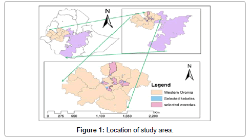
Figure 1: Location of study area.
Data sources
The study was carried out with in six (6) selected woreda of western oromia: Diga (Lalisa Dimtu and Demeksa PAs), Jimma Arjo (Abote didessa and Hindhee PAs), Gida Ayana (Anger Gutin PA), Sibu-sire (Cari PA), Bako Tibe (Sedan kite and Biqiltu Leku PAs) and Cheliya (Jarso Dire and Tulu kosoru PAs). Two types of data were used in this study, primary and secondary data. The primary data were collected from the households’ survey through two complementary approaches, namely (i) Key informant interviews) and (ii) farmer interviews using semi-structured household questionnaires.
Purposive sampling was used in determining individuals for administration of questionnaires, identifying key informants and focus group. In eastern Wollega; Sibu-sire, Diga, Jima Arjo, Gida Keremu, and from West Shewa Bako-Tibe and Chaliya Woredas were selected. The data used for the study was a long-term (historical) rainfall and temperature climate records. To assess the farmers’ perception on agro climate (mainly rainfall and temperature) about 210 farmers were interviewed using a semi-structured questionnaire that elicited information on dry spell lengths, onset, cessation and length of growing season to plan the agricultural operations better, particularly land preparation and sowing. Available historical grid climate data on precipitation and temperature of western Oromia, for the period from 1980 to 2014 were obtained from National Meteorology Agency of Ethiopia.
Method of data analysis
The collected data was analyzed by use of both quantitative and qualitative approaches. The quantitative data collected through household survey method were analyzed using Statistical Package for Social Sciences (SPSS); while qualitative data from focus group discussions, questionnaires and key informant interviews was analyzed by establishing the categories and themes, relationships/patterns and conclusions in line with the study objectives of Gray. INSTAT plus (v3.6) Software was used to characterize the climate of the study area. Mainly, historical meteorological data (rainfall and temperature data) were used to characterize the climate of the study area. Daily mean rainfall was calculated, and cumulative mean daily rainfall curve was used to estimate possible late start and early end of growing season. Total rainfalls, number of wet days and dry spell within 30-day periods in each season were computed and hence simple linear trend analysis for each characteristic was carried out. To ascertain if farmers’ perceptions of agro climatic characterization correspond to actual long term climatic records, climatic data for western Oromia were analyzed and compared with the survey results. The precipitation analyses were done using monthly rainfall from more than 30 stations distributed around western Oromia. The monthly totals were computed using Microsoft Excel and Instat+ software. The computed monthly, annual and seasonal were mapped using ArcMap 9.3. The average values at the stations were used in the interpolation using the ordinary kriging method to obtain a surface. Kriging method was chosen ahead of the other interpolation method because it tends to recognize the trend of the data to be interpolated.
Results and Discussion
Characteristics of the respondents
From the 210 respondents included in the sample, 70.48% were male and the rest 29.52% were female. The ages of household head respondents were ranges from 20 to 70 years old. Around 44.3% of the respondents were below 40 years old and about 55.70% were above 40 years old. Marital statuses of respondents were; 93.33% married from the sampled households. From the total respondents around 66.2% can read and write and 33.8% household heads respondents were illiterate with no formal education (Table 1). Even though most of respondents have formal education, their perception of climate impacts and adaptation are expected to be high.
| Characteristics of the respondents | Frequency | % respondents | |
|---|---|---|---|
| Sex of HHs | Male | 148 | 70.5 |
| Female | 62 | 29.5 | |
| Marital status of HHs | Single | 5 | 2.4 |
| Married | 196 | 93.3 | |
| Widowed | 6 | 2.9 | |
| Divorced | 3 | 1.4 | |
| Educational levels | Illiterate | 71 | 33.8 |
| Read and Write | 53 | 25.2 | |
| First cycle complete | 59 | 28.1 | |
| Secondary education complete | 19 | 9.0 | |
| High school complete | 8 | 3.8 | |
| Ages of household | 19-30 | 13 | 6.2 |
| 31-40 | 80 | 38.1 | |
| 41-50 | 64 | 30.5 | |
| 51-60 | 28 | 13.3 | |
| 61-70 | 25 | 11.9 | |
| Current occupation | Farmer | 201 | 95.7 |
| Trader | 3 | 1.4 | |
| Farmer and Trader | 5 | 2.4 | |
| Daily laborer | 1 | .5 | |
Table 1: Characteristics of the respondents.
Local community response to rainfall onset and cessation date
The onset date of Kiremt (Ganna) rainfall of study area over the last 15 years shown that on the mid of May and the cessation date of Kiremt,rainfall was last week of November (Figure 2). Farmers perceived late onset of rain, poor distribution within the season, and sometimes early cessation. In particular, they noted that the season had shifted from a start in Late April to mid-May and ended in late November. During the past 15 years, farmers highlighted the existence of problems specifically concerning variability in duration, time and intensity of the rains. Information on the date of onset and cessation date of rains will help to plan the agricultural farming better, particularly land preparation, sowing and harvesting.
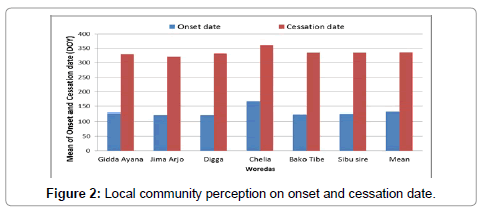
Figure 2: Local community perception on onset and cessation date.
Response to dry spell
The average length of dry spell during the Kiremt season over the study area was too long. The probability of dry spells lengths of 5, 7, 14 and 21 days observed in Kiremt season during the growing season. The probability of being 14, 7, 21, 5 days dry spell was about 41%, 27%, 13% and 11% in the kiremt seasons respectively (Figure 3). For this reason, cropping needs a great attention in selecting the appropriate sowing date in order to avoid the long dry spells during the flowering stage to reduce the possible negative impacts.
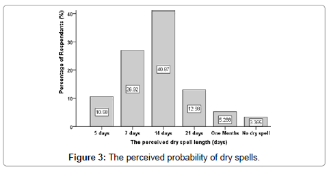
Figure 3: The perceived probability of dry spells.
Perception of respondents on agro climate
Both women and men commonly share the same observations on climatic conditions. In the study area farmers perceived an increase in temperature and changing rainfall patterns. Due to this reason the growing season became shorter, because of the onset rain shifting from late May to early June and rainfall cessation shifting from early December to early November. Even some of the respondents explained that their observation as onset of the rainy season has become less predictable. Several changes have been perceived in climate conditions over the past 20 years, according to the respondent. While the identified most significant changes have been unpredictable rains (60.48% of the respondents), very hot season (20.95% of the respondents) and prolonged drought (14.29% of the respondents) (Figure 4). According to most respondents, the observed changes in climate have resulted in crop fail and reduction in productivity (43.8% of the respondents). Other impacts of weather changes include livestock disease, increased crop diseases, weeds intensification and increased in seasonal flooding. According to respondents the major factors that negatively influence livestock farming in western Oromia are lack of pasture (28.10% of the respondents), inadequate grazing land (28.10% of the respondents), and livestock diseases (20% of the respondents), water scarcity (19.05% of the respondents), lack of market (4.3% of the respondents) and pest (1.2% of the respondents) (Figure 5). Despite 100% of respondents perceived temperature change, out of these respondents, about 76% of the informants took responses to increased number of hot days over the last 20 years.
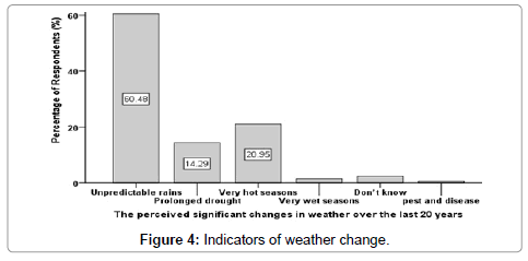
Figure 4: Indicators of weather change.
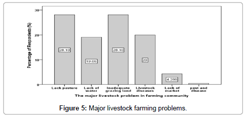
Figure 5: Major livestock farming problems.
Changes in crop calendar
During the assessment, farmers were asked to report beginning of growing season and end of growing season of major crops in the area in the past 20 years and now. Their response indicated that the present crop calendar is shorter than it was before. As a result, the cropping trend shifted towards selection of different crop varieties that adopt shorter planting season. Because of this problem most crops are planted today during mid-last May to early of July whereas maturity time is during last October. Hence, the growing period of major crop has shortened by almost one-month duration as compared to before. This could indicate a demand shifting towards faster-growing/early maturing varieties with higher drought resistance. The reduction in the growing period of crops more likely resulted from increase in temperature and erratic rainfall (Figure 6).
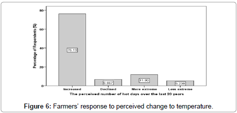
Figure 6: Farmers’ response to perceived change to temperature.
Climate impacts on natural resources
Assessment made on households at major areas of environmental resources in the study area in Table 2. According to the assessment made, 82% of the respondents agree the decreasing trend of drinking water availability for animals. Moreover, 73% of them even agree the decreasing pattern of water availability in general. Similarly, about 92% of the household’s respondent, in the study area, perceived a reduction of forest coverage whereas about 85% of the respondents were assured an increment of the problems of soil erosion in western Oromia.
| Major areas of assessment | Frequency | % of respondents | |
|---|---|---|---|
| Availability of water for animals | Increasing | 11 | 5.2 |
| Decreasing | 172 | 81.9 | |
| No change | 27 | 12.9 | |
| Forest cover | Increased | 11 | 5.2 |
| Decreased | 193 | 91.9 | |
| No change | 6 | 2.9 | |
| Problem of soil erosion over time | Increased | 178 | 84.8 |
| Decreased | 26 | 12.4 | |
| No change | 6 | 2.9 | |
| Water availability | Increased | 21 | 10.0 |
| Decreased | 153 | 72.9 | |
| No change | 36 | 17.1 | |
Table 2: Households assessment on major areas of environmental resources.
Historical climate data characterization
To characterize the agro-climatic, as a first step, the climatic data was classified according to the seasons i.e., Bega (DJF), Kiremt (JJA), Belg (MAM) and Tseday (SON). The area characterized as mono modal type of rainfall. The longest rainy season was from June to August locally called “Kiremt” had received the highest amount of rainfall from 1000 to 2100 mm, especially on the month of July and August. The “Bega” (dry) season from December to February had received from 63 to 360 mm. “Kiremt” is the main rainfall season for the region which is very useful for agricultural production. As seen from the seasonal map, less than 1000 mm is received over the west Shewa and Qelem wellega in kiremt. The mean seasonal rainfall varies quite a lot throughout the area with the minimum of 63 mm recorded at Gore (in Bega), and the maximum of 1440 mm recorded at Nekemt (in Kiremt). Monthly rainfall varies with both space and time.
The spatial distribution shows high monthly rainfall over the central parts of the western Oromia. The least rainfall is in Bega (December- February) when the agricultural crops are mostly at maturity stage and harvest. The lowest mean Belg (March-April) seasonal amounts of rainfall were observed at West Shewa, Horro Guduru Wellega, West and Qelem Wellega. In contrast, the highest Belg (March-April) seasonal amounts are recorded at Ilu Aba Bor and Jimma. The mean seasonal rainfall distribution quite varies throughout the study area with low recorded in West Shewa, some parts of West and Qelem Wellega, and the highest amounts registered in Ilu Aba Bora, Jimma and East Wellega (Figure 7). West Shewa received relatively low amount of rainfall during Bega (December-February) season with less than 150 mm.
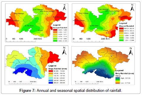
Figure 7: Annual and seasonal spatial distribution of rainfall.
Annual rainfall and temperature trends
Results showed that the average annual minimum and maximum temperature of Bako had an increasing trend which was statistically significant (Figure 8a). But, the average annual rainfall of Bako had decreasing trend which was statistically significant (Figure 8a). This means that the woreda has been experiencing significantly reducing rainfall and warmer temperatures with time and this confirms the farmer’s perception.
The average annual rainfall of Chelia district shows decreasing trend which was statistically not significant (Figure 8b). However, average annual minimum and maximum temperatures in Chelia had an increasing trend which was not statistically significant (Figure 8c). Similar to Chelia district, in Sibu-sire, Jima Arjo, Gida Keremu and Diga, the average minimum and maximum temperatures had an increasing trend that was not statistically significant (Figures 8c-8f). On the other hand the average annual rainfall had decreasing trend for Sibu-sire, Gida Keremu and Diga (Figure 8c, 8e and 8f) but increasing trend for Jima Arjo (Figure 8d) which was statistically significant. The average minimum and maximum temperature of Bako has risen by an average of 0.35°C and 0.91°C per decade, respectively between 1980 and 2013; while the average annual rainfall had decreasing by an average of 23 mm per decade (Figure 8).
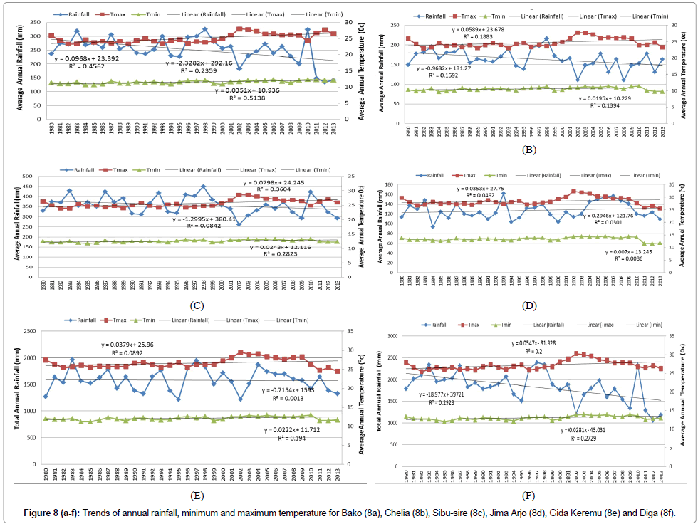
Figure 8(a-f): Trends of annual rainfall, minimum and maximum temperature for Bako (8a), Chelia (8b), Sibu-sire (8c), Jima Arjo (8d), Gida Keremu (8e) and Diga (8f).
In Chelia, Sibu-sire, Jima Arjo, Gida Keremu and Diga, the average minimum temperatures showed an increasing trend at a rate of 0.20°C, 0.24°C, 0.07°C, 0.22°C and 0.28°C per decade, respectively. Similarly, the average maximum temperatures showed an increasing trend at a rate of 0.59°C, 0.80°C, 0.35°C, 0.38°C and 0.54°C per decade respectively (Figures 8c-8f)). Contrarily, the average annual rainfall showed a significant decreasing trend (9.68 mm, 13 mm, 7.15 mm and 18.98 mm per decade) in Chelia, Sibu-sire and Gida keremu, respectively with a relatively large inter-annual variability, while increasing trend in average annual rainfall of Diga at rate of 2.95 mm per decade.
Onset and cessation date from historical climate data analysis
The onset date of the growing season in the western Oromia ranged mid-May to early June) with the mean onset of first June. The end date of the growing season (EOS) for the study area ranged from mid-September to last November with the mean end date of the growing season (EOS) mid-October (Figure 9). This Onset and cessation date from historical climate data where different from the farmer’s perceptions. The community perceptions on onset date lags from historical climate by three weeks and exceed cessation date by almost one month. For this reason, the crop needs a great attention in selecting the appropriate sowing date in order to avoid the long dry spells during the flowering stage and reduce the possible negative impacts. Therefore, knowledge on the date of onset of rains will help to plan the agricultural operations better, particularly, land preparation, sowing and harvesting.
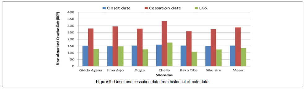
Figure 9: Onset and cessation date from historical climate data.
Dry spell length from historical climate data
Probability of different dry spells longer than 5, 7, 14 and 21 days were analyzed. The mean probability of dry spells to be 5 days was 40% during the early June and the probability of dry spells of 5 days is 60% during last of -August. All dry spell probability curves converge to their minimum during the peak rain season. The mean probability of dry spells of 7 days is 20% during early June and August (Figure 10). This also confirm with the community perception where the dry spell length occurred during rainy season.
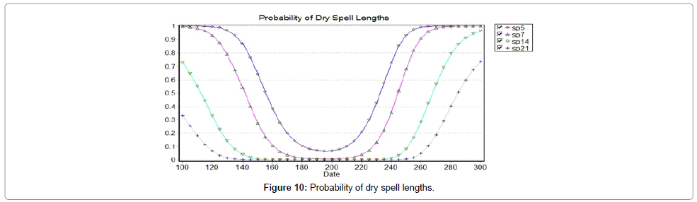
Figure 10: Probability of dry spell lengths.
Dry season causes high probability occurrence of long dry spell while low probability of dry spell happens during rainy seasons. As it was presented in Figure 10 the probability of occurrence of 5, 7, 14, 21 day dry spells is not more than 20% during pick rainy season.
Conclusion
The result of the study illustrated that integrating indigenous and scientific knowledge would provide an insight in designing proper agricultural practices and identification of optimum sowing date as a strategy to minimize crop failure and yield reduction. In areas where communities dependent on rainfall; providing information about the distribution, onset date, end date and duration of rainfall is crucial for agricultural activities. This approach could be very useful in obtaining valuable climate and agronomic information for different decisions.
Climate trends over western Oromia have shown an increasing trend in minimum and maximum temperatures and reducing trend in rainfall over the past few decades. Seasonally, amount of rainfall were quite varies with relatively higher rainfall recorded during kiremt months than Bega and Belg months. Hence, in the majority of the rainfall stations of west Oromia, June to August (kiremt) is the period in which highest rainfall has been recorded whereas December- February (Bega) is the period of low rainfall were recorded. Annual rainfall is highest over the Ilu Aba Bora, Jimma and Easts Wellega while the West Shewa and the Qelem Wellega receives less rainfall. From the respondents view point and climatic data analysis, it is concluded that frequent drought, flood, diseases and pests, variability of rainfall (onset and cessation date as well as distribution) and increase in temperature, significant reduction in length of growing as a result of temperature increment and erratic rainfall, increased dry spells and other had been the main problem of the study area that caused due to climatic change. These all problems have got negative impact on production and productivity that highly affected the livelihood of the community.
Generally, except for onset and cessation date differences, the community perceptions and historical climate data analysis results basically conceded or support each other. Therefore, integrating indigenous and scientific knowledge would provide good skill and information that contribute for appropriate agricultural planning in order to avoid agro climatic risks.
Acknowledgement
The author thanks Oromia Agricultural Research Institute for their financial support.
References
- Rosenzweig C, Parry ML (1994) Potential impact of climate change on food supply. Nature 367: 133-138
- Suryabhagavan P (2017) GIS-based climate variability and drought characterization in Ethiopia over three decades. Weather and Climate Extremes 15: 11–23
- Aleme S (2015) Agro climatic characterization of the western zone of Tigray region, Humera. Journal of Environment and Earth Sciences 5: 24-29
- Gebreegziabher Z, Mekonnen S, Alemu A (2011) Climate change and the Ethiopian economy: A computable general equilibrium analysis. Environment for Development Discussion Paper Series 24
- Sinebo W, Lake W (2010) Bi plot analysis of grain yield in barley grown under differing management levels in years of contrasting season-end drought. Plant Breeding and Crop Science 152-164
- Berger J, Turner N (2007) Chickpea breeding and management. W. C. The ecology of chickpea in: RSS Yadav and B Sharma (Eds.) 47: 71
- NMSA (1996) National meteorological service agency: Climate and agro climatic resources of Ethiopia. Meteorological Research Report no. 1. Addis Ababa, Ethiopia. p: 137.
- Mersha E (1992) Agro climatic analysis for sustainable development agricultural, planning in Ethiopia. WMO/UNDP Project Eth/86/021. Addis Ababa, Ethiopia. p: 172.
- Reddy MS, Giorgis K (1993) Dryland farming research in Ethiopia, a review of the past and trust in the nineties institutes of agricultural research. Addis Ababa, Ethiopia. p: 107.
- Shiferaw H, Gebremedhin A, Tsehaye Y, Gebresamuel G, Zenebe A, et al. (2015) Characterizing climate for agricultural production and best sowing dates to minimize crop failure: The case of Kelte-Awelalo Woreda Tigray. Int J Multidisciplinary and Current research 3: 558-563
- Daba MH (2018) Assessing local community perceptions on climate change and variability and its effects on crop production in selected districts of Western Oromia, Ethiopia. J Climatol Weather Forecasting 6: 216
- Amukono CL, Bosire E, Lukorito C (2016) Agro climatic characterization of Makueni County using rainfall data. University of Nairobi, Kenya
- Fita T (2014) White Mango Scale, Aulacaspis tubercularis, Distribution and severity status in east and West Wollega Zones, Western Ethiopia. Sci Technol Arts Res J 3: 01-10
- Fed B (2008) Oromia Atlas: Oromia Finance and Economic Development Bureau. Addis Ababa, Ethiopia.
- ORHB (2010) Oromia Regional Health Bureau. Five-year health performance report. Addis Ababa, Ethiopia.
Citation: Daba MH (2018) Agro Climatic Characterization in the Selected Woredas of Western Oromia, Ethiopia. J Earth Sci Clim Change 9: 455. DOI: 10.4172/2157-7617.1000455
Copyright: © 2018 Daba MH. This is an open-access article distributed under the terms of the Creative Commons Attribution License, which permits unrestricted use, distribution, and reproduction in any medium, provided the original author and source are credited.
Select your language of interest to view the total content in your interested language
Share This Article
Recommended Journals
Open Access Journals
Article Tools
Article Usage
- Total views: 9583
- [From(publication date): 0-2018 - Oct 23, 2025]
- Breakdown by view type
- HTML page views: 8402
- PDF downloads: 1181