An Explained Typology of Natural Disasters in the State of Uttarakhand, India: Preparedness and Response Mechanism
Received: 07-Oct-2021 / Accepted Date: 01-Nov-2021 / Published Date: 08-Nov-2021 DOI: 10.4172/2573-458X.1000242
Abstract
There is a need for coordinated and integrated disaster preparedness and response mechanism in the Uttarakhand State, across various institutions and human habitations as additionally along with the transient measurement in that previous occasions and future dangers should be examined corresponding to each other and its relationship for a viable system for disaster risk reduction. Moving above and beyond, endeavor ought to be made to unite as incorporated worldwide risk reduction framework, which analyses regional susceptibilities of people and the region. This proposed inquiry concentrates on means to investigate the relationship between disaster preparedness and response and a considerable and bankable recovery from the disaster, which will endure through and continue to go long. Using a grouping of abstract and quantitative outline system assessment, and exploratory research techniques, this investigation paper separated the evidence of disaster response close by the readiness and alleviation methodologies, and their assurance for significant and sensible recovery from the disaster impact and influence. The closeness of more essential disaster the board practice and better, faster recovery from the calamity was found to be intelligent and real ponders. The paper found that the higher the size of disaster encroachment, the more essential the counter–vote– based energy for a veritable and epic recovery from a disaster in the State. The examination obviously reacts to the quest with respect to the sociological way to deal with and handle natural disasters.
Keywords: Preparedness; disaster response; risk reduction; Exploratory; Sociological; Hazard
Introduction
The perception of disaster has progressed from a totally technodriven perspective to a sociological and natural and ecological perspective to unraveling the wonders identified with calamities. Through a huge part of the twentieth century, the speculation and practice of calamity the board had been overpowered by the coherent perspective, whereby, disasters were thought about basically as a topographical, geological, or a climactic issue, the responses for which lay in designing and the regulatory and administrative sciences. Over the latest twenty years, there has been a paradigmatic change in the cognizance of disasters in that the human factor, which had been ignored in the past procedure, is as of now in the middle, it is currently human-engaged and focused. The undertaking along these lines is to ask into sociological cycles and potential outcomes that choose or undermine a neighborhood, adjusting cutoff, and respond to disasters. Appreciation of disasters as of not long ago had been limited to typical risks. Eventually, the term disaster is a more thorough thought, in that it fuses man-made and mechanical dangers, as also mental abuse, which has added one more estimation to its arrangement.
There are two important perceptions on disasters. According to one school of thought, disasters are natural, vengeful acts of nature: an opportunity for man to atone for his sons, wherein death and destruction are inevitable. As per the other perspective, disasters are man-made. An event whether a product of natural phenomena or human activities turns out to be a catastrophic disaster if the community or society fails to adequately cope up with it. By systemic understanding, hazard simply acts as a ‘catalyst’ in that it brings forth underlying tensions that are always present as potential pressure [1].
From the ecological perspective, “disasters are totalizing events in which all dimensions of a social structural formation, involving organized human action in the environmental context in which it takes place are studied. The ecological concept of disaster as a total event involving interaction between environment and nature follows the social perspective on disaster by which hazards are understood to arise when there is lack of mutual relation between the environment and man” [2]. As a society interacts with the environment, with its values and perceptions and engages in a series of processes over which it has incomplete control and knowledge, for example, development and planning processes, production and distribution of goods, over long periods of time, underlying hazards turn to disasters [3].
Theoretical Understanding of Relevant ConceptsFor the sake of conceptual clarity, it is desirable to clear the semantic confusion between three interrelated terms, viz. hazard, risk, and vulnerability, which are used often in disaster literature. Such an exercise is necessary for a view of the fact that a major part of disaster management theory and practice involves scientific precepts and analyses, which requires precision in the terminology used. Project planners are required to present an inventory of risks from specific hazards, risks, and vulnerability factors that require exactitude in definitions. Hence, the hazard is defined as a potential or a latent/ dormant cause, which is activated when the right configuration of factors; natural or manmade or both, present themselves. For example, a chemical plant in a populated area is a potential threat to life and property within defined vicinity; hence a hazard. Disaster is the actual occurrence of the apprehended catastrophe. Hence, disaster is “any occurrence, that causes damage, ecological disruption, loss of human life, deterioration of health and health services, on a scale sufficient to warrant an extraordinary response from outside the affected community or area.” World Health Organization (WHO)
A hazard technically is not a disaster unless the ‘trigger’ (natural or man-made) sets it off. The trigger could possibly be the weak legislation that failed to regulate the functioning of the facility, as was the case in the Bhopal gas tragedy. Hence a “disaster should be defined on the basis of its human consequences, not on the phenomenon (hazard) that caused it. That precisely brings out the difference between disasters and hazards. Earthquakes, floods, and cyclones are ‘natural hazards’ which cause large-scale loss of life and property (disaster) when the trigger mechanism (natural or man-made) is activated. Till then, they are simply events in nature. A hazard may or may not lead to an event, or the event in itself may or may not cause damage. Such probabilities are determined by the vulnerability of ‘elements’ at risk.
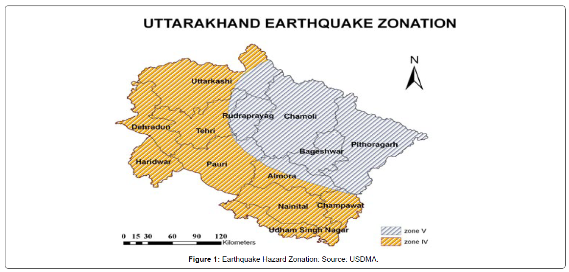
Vulnerability is the extent to which an ‘element’ (animate/ inanimate) is harmed in the event of a disaster; in other words, is susceptible to a given hazard. ‘Elements’ are identified as life and property likely to suffer damage in the event of a disaster. Observation and perception of risk involve ascertaining, specifically, such ‘elements’ at risk. Identification of risk involves inquiring into the specific natural, technological or chemical, etc., processes that create the vulnerability of the elements identified for risk analysis”. Vulnerability can be natural or man-made. It can be physical, owing to factors such as weak buildings, habitation in hazard-prone areas; or socio-economic, arising due to poverty or marginalization of the weaker sections of society who lack the wherewithal of defending themselves in the event of a disaster. The aforesaid concepts are discussed below in detail (Figure 1).
Hazards and Disasters: A DifferentiationThe International Secretariat for Disaster Reduction (ISDR) defines a hazard as “a potentially damaging physical event, phenomenon or human activity that may cause then loss of life or injury, property damage, social and economic disruption or environmental degradation.” Hazards could be, natural (geological, hydro-meteorological, and biological) or induced by human processes (environmental degradation and technological hazards). Hazards can be single, sequential, or combined in their origin and effects. Accordingly, Hazard analysis entails the identification, study, and monitoring of a hazard to determine its potential, origin, and characteristics. A fine line separates environmental hazards and environmental resources, as between water out of control (flood hazard) and water under control (reservoir resources). The atmosphere is considered ‘benign’ when it produces holiday sunshine but ‘hostile’ when it produces damaging ‘loo’.
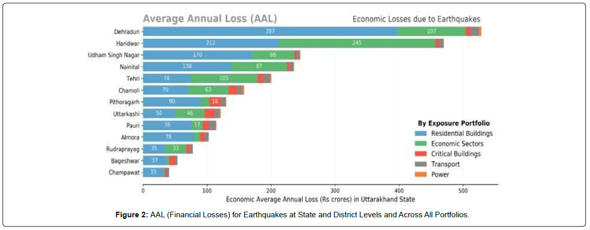
It is seen that from one side of the planet to the other, there is an extension in the occasion and antagonistic impact of disasters, typical similarly as man-made. Notwithstanding enhancements in science and advancement, there is a sharp climb in calamities and disasters. In 2002, it has been surveyed that most fatalities happened in light of floods and seismic tremors over the world. Uttarakhand has encountered countless occasional and glimmer floods, including quakes that have shaken and shocked the area in every possible measurement. Uttarakhand is prone to natural hazards mainly caused by water, (floods, flash floods, heavy precipitation, avalanches, landslides, droughts, hail, lightning), as well as cold waves and earthquakes. The recent calamity due to heavy downpours and subsequent devastating floods in various rivers on 16- 17 June 2013 led to heavy losses of life and property. Unprecedented floods and landslides have rendered many locations along the riverbanks vulnerable to losses. Besides affecting the life of the people adversely, such calamities also disrupt habitations around the rivers that contribute significantly towards total national agricultural and industrial product value (Figure 2).
The Himalayan district is profoundly defenseless against disastrous earthquakes and has been crushed by four Great Earthquakes (Magnitude 48 on Richter Scale); 1897 Shillong, 1905 Kangara, 1934 Bihar–Nepal, and 1950 Assam quakes separated from Kumaun and Garhwal quakes of 1720 and 1803 individually. Districts between break zones of these quakes address seismic holes that have gathered expected slips for producing future Great Earthquakes. However shaken as of late by 1991 Uttarkashi, 1999 Chamoli seismic tremors the province of Uttarakhand in India falls in seismic hole of 1934 and 1905 great quakes and is distinguished as an expected site for a future calamitous tremor and earthquakes. Since the time adjustment of the southwest rainstorm owed generally to the upliftment of Himalaya, the district has been encountering weighty precipitation, for the most part, confined to storm period, blustery season over the Indian subcontinent. Restricted and unusually substantial precipitation (downpour) which is normal in the district regularly brings about trash streams, avalanches, and glimmer floods. Aside from 1894 and 1970 Uttarakhand has been crushed by floods in 2010, 2012, and 2013.
The human deaths in the frequency of 2013 outperformed 4000 and crushed Mandakini and Alaknanda valleys other than Kali, Goriganga, Pinder, Bhagirathi, and Saryu valleys. Because of upgraded pore water pressure and decreased frictional powers avalanches are normal during the rainstorm periods and the combined cost of these far outperforms that of different perils and disasters. It is assessed that each square kilometer in the Himalayas has, at any rate, two avalanche scars. In the year 1998, the state saw major avalanches in Madhyamaheshwar and Kali valleys in which human loss of life was more than 350. Most agricultural lands in the region are rain-fed and therefore failure, weakening, or delay of the southwest monsoon or winter rains results in crop failure or depleted productivity. In recent times the state has faced severe drought conditions in 2006, 2008, and 2009.
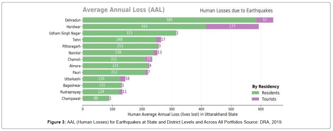
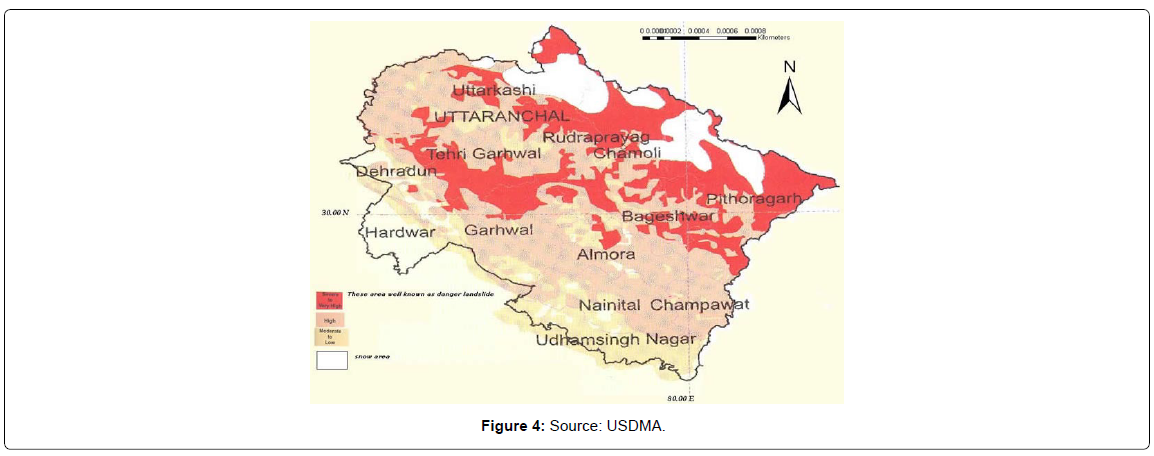
Moreover, western disturbances often induce squall and hail storms that cause measure loss of horticultural crops. Forest fires are also frequent in the region and besides causing environmental degradation these often enhance the pace of other erosional processes. Most agricultural lands in the region are rain-fed and therefore failure, weakening, or delay of the southwest monsoon or winter rains results in crop failure or depleted productivity. In recent times the state has faced severe drought conditions in 2006, 2008, and 2009. Moreover, western disturbances often induce squall and hail storms that cause measure loss of horticultural crops. Forest fires are also frequent in the region and besides causing environmental degradation these often enhance the pace of other erosional processes (Figure 3 and Figure 4).
Uttarakhand is hence inclined to various normal risks and individuals living in this territory would have frequently experienced rage of these. Guaranteeing wellbeing and coherence of the local area has been the greatest test looked at by people all through furthermore, all over. Ceaseless and unabated human presence in the locale notwithstanding the diligent and genuine danger of various perils proposes that the native individuals of this district, in view of their gained information, could sufficiently moderate misfortunes from these risks. A fundamental comprehension of the cycles promoting these dangers is anyway needed for doing as such. This should anyway not be possible without distinctly noticing different normal dangers and testing causes thereof. Comprehension of likely explanations of these risks would have driven individuals to explore different avenues regarding different likely impacting boundaries and devise methods of limiting misfortunes in ensuing occasions. It is just with this perception, experimentation, and conveying forward of the gained information that these individuals could effectively comprehend the cycles inciting these risks and devise methods of guaranteeing security from these.
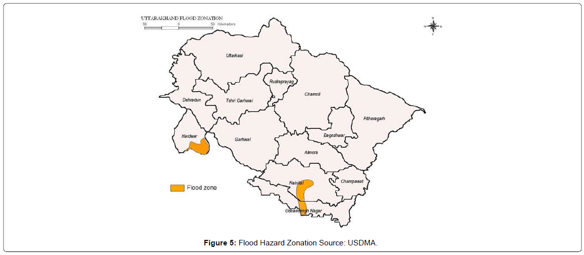
There exist enough evidence to infer that these people possessed a superior understanding of the processes underlying the hazards and devised ways of minimizing losses from these. These are talked about exhaustively in the areas underneath. Entry of this information through oral custom alone could anyway not send perceptions made during perils, for example, tremors that have long repeat stretches. Proof relating to formal documentation and transmission of information identified with these dangers stays a significant missing connection in calamity the executives related comprehension of the native individuals of this locale and similar warrants committed and concentrated exploration (Figure 5).
Natural Disasters in the State of Uttarakhand, India: Typology of natural disasters occurring in the State of Uttarakhand, India.
Earthquake threat in the Himalayas and UttarakhandEarthquake danger potential is evaluated to be especially high in the whole Himalayan landscape and before, the locale has been shocked by four incredible quakes, aside from the Kumaun Earthquake of 1720 and the Garhwal Earthquake of 1803. The pinnacle ground speed increase ( PGA ) in the Shillong Earthquake of 1897 is assessed to have surpassed 1 gr Oldham while around 18,000 people were purportedly killed in the 1905 Kangara Earthquake (Middlemiss, 1910). The whole Himalayan territory falls in Zone V and Zone IV of Earthquake Zoning Map of India (IS 1893 (Part 1), 2002) that isolates the Indian landmass into four unmistakable danger zones; Zone II to Zone V.
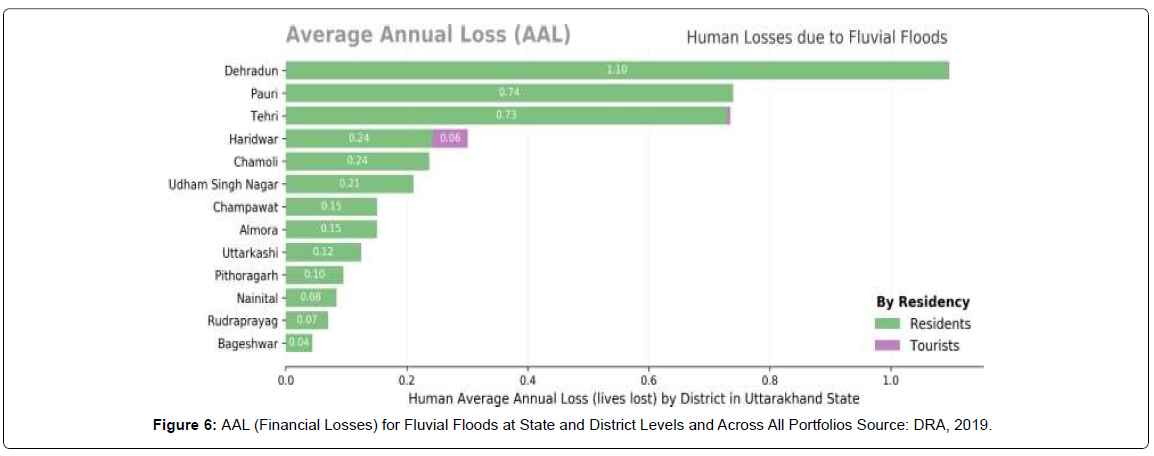
Quake force can arrive at VIII on MSK Scale in Zone IV, while in Zone V it can arrive at IX or significantly more. In the new past (1991 and 1 9 9) the State of Uttarakhand has seen the destruction brought about by two quakes (Uttarkashi and Chamoli) and being navigated by major Himalayan structural discontinuities (Himalayan Frontal Fault; HFF, Main Boundary Thrust; MBT and Main Central Thrust; MCT) the State is regularly shaken by tremors of lesser greatness. The State of Uttarakhand has anyway not encountered an incredible tremor (Mw ≥ 8.0) for more than the past 200 years and continually amassing strain hence stays due for discharge in this area. The area is along these lines displayed as falling in the seismic hole of 1934 and 1905 extraordinary tremors (Yeats and Thakur, 1998). Since more modest tremors don't happen adequately as often as possible to oblige the noticed intermingling of Indian and Eurasian plates, there is a reformist strain developed in what are perceived as seismic holes Falling in seismic hole whole State of Uttarakhand is deciphered to have collected likely slip for creating future extraordinary quakes. Having been recognized as a likely locale for a future calamitous quake is a reason for worry for oneself and all, especially those living around here (Figure 6).
LandslideThe Himalayas alone count for landslides of every fame, name, and description- big and small, quick and creeping, ancient and new. The Northeastern region is badly affected by landslide problems of a bewildering variety. Landslides in the Darjeeling district of West Bengal as also those in Sikkim, Mizoram, Tripura, Meghalaya, Assam, Nagaland, and Arunachal Pradesh pose chronic problems, causing recurring economic losses worth billions of rupees. A different variety of landslides, characterized by a lateritic cap, pose a constant threat to the Western Ghats in the South, along the steep slopes overlooking the Konkan coast besides Nilgiris, which is highly landslide-prone. Some spectacular events of tragedies are reported as Varnavat landslide, Uttarkashi District, Malpha landslide Pithoragarh district, Okhimath landslide in Chamoli district, UK, and Paglajhora in Darjeeling district as well as Sikkim, Aizawl sports complex, Mizoram. These are some of the more recent examples of landslides. The problem, therefore, needs to be tackled for mitigation and management for which hazard zones have to be identified and specific slides to be stabilized and managed in addition to monitoring and early warning systems to be placed at selected sites (Figure 7).
Cloudbursts
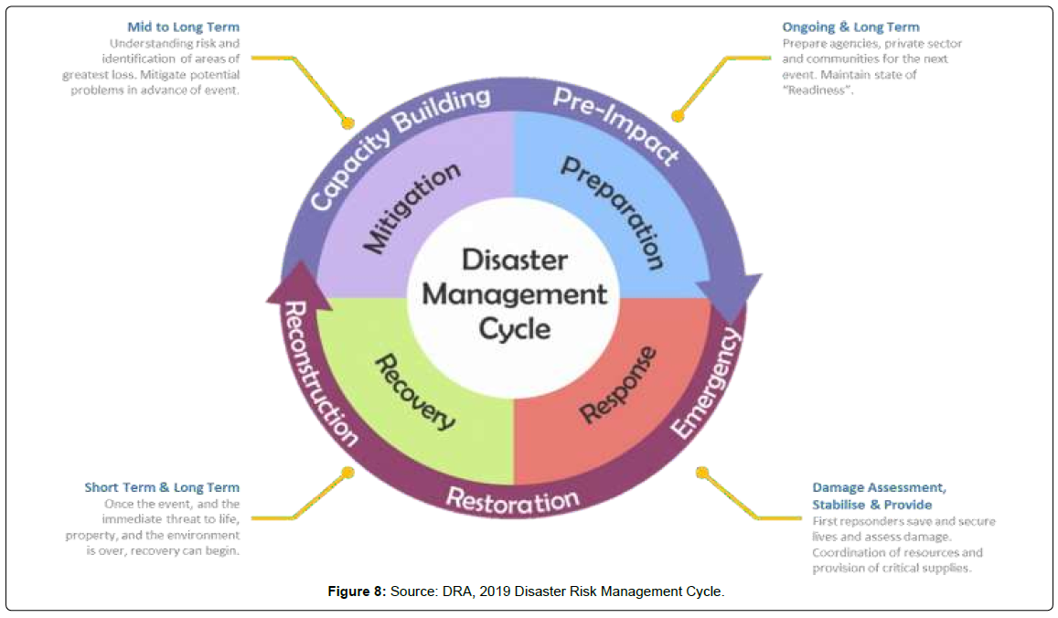
In recent times extreme rainfall events as cloudbursts are dominant phenomenon trigger large scale mass movement and flash floods in the Himalayan region. Cloudburst is a natural and common phenomenon in the Himalayas, especially in the Garhwal and Kumaon regions of Uttarakhand. Cloudburst and associated disasters affect thousands of people every year and cause loss of life, property, livelihood, infrastructure, and the environment. Almost every year several parts of Uttarakhand Himalaya experience cloudburst and associated hazards. Cloudburst during August 1998 at Ukhimath (Rudraprayag) and Malpa (Pithoragarh), August 2001 at Phata (Rudraprayag), August 2002 at Burakedar (Tehri), August 2012 in Asi Ganga (Uttarkashi), September 2012 at Ukhimath (Rudraprayag), and June 2013 at Kedarnath (Rudraprayag) are some of the examples of recent cloudburst incidences associated with flash floods and landslides in Uttarakhand Himalaya. The Cloudburst is a natural phenomenon that generally occurs during the monsoon period over many regions of the Himalayas (Figure 8).
Generally, cloudburst refers to particularly heavy precipitation in a short period of time over a limited geographical area. It is often defined as more than 100 mm/hour rainfall within a limited geographical area of a few square kilometers. The landforms of the Uttarakhand Himalaya located above 1200 meter altitude are extremely sensitive for the cloudburst-induced landslides during monsoon season. Cloudburst incidences over many areas of the Himalayas often go unnoticed due to the absence of meteorological observatories. Many times these come to notice only when these are accompanied by losses and casualties. In the absence of losses, these can only be identified on the basis of inundation occurring along streams. Mostly upper reach of the first order and second order drainages (seasonal streams) have been observed to be overwhelmed by debris flow during these incidences. Slope failures and bank erosion are common during this phenomenon which results in sedimentation and sometimes blocks the river course, turns them into big lakes, and creates flood conditions.
Considering extreme rainfall events in Uttarakhand Himalaya, it is suggested that instead of valleys and along the abandoned channels of drains people should inhabit on the hard rock or firm ground of slopes for safety reasons. At locations where ground fissures have developed and subsidence has taken place appropriate measures are required for checking infiltration of rainwater as well as surface water. This should precede the implementation of permanent treatment measures. People living around these slopes should remain vigilant, particularly during the monsoon period and any physical change in the slope should immediately be brought to the notice of authorities. On the basis of information collected from the local people, strong wind and lightning are very common during cloudbursts. Even though locals consider it to be a cloudburst event it is hard either to accept or reject their assertion in absence of authentic meteorological data from the proximity of slope failure incidences. Indiscriminate and unscientific construction should be banned especially in landslideaffected areas. Besides this safe disposal of rainwater needs to be given due importance.
Both surface and subsurface drainage measures should therefore be planned and executed. For this drain pipes could be provided on debris slope. The planned drainage network should be stepped and wide enough to accommodate heavy downpour events. Increasing anthropogenic activities, venturing in unsafe areas due to limited land availability and heavy localized precipitation, are continuously increasing the landslide vulnerability in Didihat town as well as the hilly terrain of Uttarakhand. In case indiscriminate and unscientific construction could not be regulated all mitigation and treatment measures would remain a mere formality and would be of little use. The bioengineering technology can be successfully implemented by using specific and local vegetation along with engineering measures to reduce instability and soil erosion. Although it is difficult to forecast cloudburst events, the dense network of rain gauges particularly in the areas identified as being vulnerable to cloudburst is required for a better understanding of this phenomenon. Accurate measurement of such events and studies based on different aspects of geology, geomorphology, and climatology could help in developing a cloudburst forecasting model. Such studies would at the same time result in efficient landslide risk mitigation. At the same time, awareness about the extreme precipitation events and associated disasters among the dwellers of the area is needed.
Floods
India is highly vulnerable to floods. Out of the total geographical area of 329 million hectares (mha), more than 40 mha is flood-prone. Floods are a recurrent phenomenon, which causes huge loss of lives and damage to livelihood systems, property, infrastructure, and public utilities. It is a cause for concern that flood-related damages show an increasing trend. The average annual flood damage in the last 10 years period from 1996 to 2005 was Rs. 4745 crore as compared to Rs. 1805 crore, the corresponding average for the previous 53 years. This can be attributed to many reasons including a steep increase in population, rapid urbanization growing developmental and economic activities in flood plains coupled with global warming. On average every year, 75 lakh hectares of land are affected, 1600 lives are lost and the damage caused to crops, houses, and public utilities is Rs.1805 crores due to floods. The maximum number of lives (11,316) was lost in the year 1977.
The frequency of major floods is more than once in five years. Floods have also occurred in areas, which were earlier not considered flood-prone. An effort has been made in these Guidelines to cover the entire gamut of Flood Management. Eighty percent of the precipitation takes place in the monsoon months from June to September. The rivers bring heavy sediment load from catchments. These, coupled with an inadequate carrying capacity of rivers are responsible for causing floods, drainage congestion, and erosion of river-banks. Cyclones, cyclonic circulations, and cloud bursts cause flash floods and lead to huge losses. It is a fact that some of the rivers causing damage in India originate in neighboring countries; adding another complex dimension to the problem. Continuing and large-scale loss of lives and damage to public and private property due to floods indicate that we are still to develop an effective response to floods. NDMA's Executive Summary Guidelines have been prepared to enable the various implementing and stakeholder agencies to effectively address the critical areas for minimizing flood damage.
Flash Flood
A flood caused by heavy or excessive rainfall in a short period of time, Flash floods are usually characterized by raging torrents after heavy rains that rip through river beds, urban streets, or mountain canyons sweeping everything before them. They can occur within minutes or a few hours of excessive rainfall. They can also occur even if no rain has fallen, for instance after a levee or dam has failed, or after a sudden release of water by a debris or ice jam. The intensity of the rainfall, the location and distribution of the rainfall, the land use and topography, vegetation types and growth/density, soil type, and soil water content all determine just how quickly the Flash Flooding may occur, and influence where it may occur. A recent disaster that occurred in Uttarakhand is a typical example of such flash flood disasters taking a massive toll on the human life and property in the region.
A glacier burst in Chamoli district caused flash floods killing several people. On Sunday morning, a glacier burst in Reni village of Chamoli in Garhwal Himalayas of Uttarakhand caused a flash flood in the Rishiganga river. The flood is likely to have killed around 100- 150 people. The massive flood in Dhauliganga and Joshimath which was reported near Reni village, 26 km from Joshimath, destroyed many houses situated on the river bank [4].
Disaster struck Uttarakhand’s Chamoli district on February 7, 2021, in the form of an avalanche and deluge, after a portion of the Nanda Devi glacier broke off. The sudden flood in the middle of the day in the Dhauli Ganga, Rishi Ganga, and Alaknanda rivers — all intricately linked tributaries of the Ganga — triggered widespread panic and large-scale devastation in the high mountain areas. Two power projects — NTPC’s Tapovan-Vishnugad hydel project and the Rishi Ganga Hydel Project — were extensively damaged with scores of laborers trapped in tunnels as the waters came rushing in. At least 32 people are feared dead, and over 190 missing [5].
Avalanche
Avalanches are common in the Himalayan region with altitudes of more than 3500 meters and where the slope is generally more than 30 degrees. North-facing slopes are known to have avalanches in winter whereas south-facing slopes usually get them during springtime. In the recent past, many incidences of avalanches have been observed in higher reaches of the state like Gomukh Glacier, Hemkunt Sahib, Ghastoli, and Kalindi–Badrinath track. Since its commencement, the territory of Uttarakhand has been likely to fluctuate also, the serious scope of regular peril and disaster occasions. While a considerable lot of these are unaccounted for in the authentic record, (given the recurrence of persistent, low-power occasions, like minor landslides), a synopsis of the significant occasions for each disaster type is documented in Table 1 below.
| Hazard | Earthquakes [1] |
Landslides [2] |
Floods / Flashfloods [3] |
Cloudburst [4] |
|---|---|---|---|---|
| Number of Events |
65 from 1803-2013 | 29 major events from 1867-2013 |
28 major events from 1989 -2013 |
9 major events from 2002-2016 |
| 11 with magnitude > 6.0 Richter |
||||
| Casualties | >5400 since 1998 |
More than 6500 from 1989-2013 (~5700[5] only from June 2013 floods) |
155 |
Table 1: Sources: [1] Setendra (2003) | [2] NDMA (2009) | [3] SEOC (2011) | [4] UAEP (2016) [5] CBS news.
Uttarakhand is defenseless and has been crushed over and over by various dangers that incorporate earthquake, avalanche, flood, flash flood, dry spell, and torrential slide. These have incurred a substantial loss of living souls, framework, property, and different assets. Even though it is not always possible to prevent the occurrence of natural hazards, with effort and planning it is possible to reduce their impact. The State Disaster Management Plan (SDMP) is envisaged to lead the state towards the goal of being disaster resilient and has been designed in such a manner that it can be implemented as needed in a flexible and scalable manner during all the phases of the disaster management cycle from prevention, mitigation and preparedness through response to recovery encompassing precepts of build back better. The entire approach towards management of disasters, which has all along been relief-based, has been undergoing transformation and morphological alterations, and it is now giving a broadway open to a developmental approach to disaster handling and management, which is an existential reality in the State of Uttarakhand too.
This involves ensuring readiness on the part of several stakeholders to predict, and where possible, prevent disasters, reduce their impact and cope with its consequences. Disaster management is being looked at in a very comprehensive manner with the prevention, preparedness, mitigation, and relief built into it to foster sustainable development is being looked at in a very comprehensive manner with the prevention, preparedness, mitigation, and relief built into it to foster sustainable development. Whether disasters are natural or Inhuman-induced, their impact is felt, many times, for a long time. It is, therefore, essential that ally support operations be designed and implemented with a long-term perspective. In the past, we have been at the mercy of nature and fate, but today, we possess the knowledge, capacity, and capability to lessen the worst impact of a disaster. In the new culture of disaster management, prevention, preparedness, and mitigation are interconnected as one supplements the other.
Disasters, which occur globally with regular periodicity, are either natural such as floods, droughts, cyclones, and earthquakes, or humaninduced such as conflicts, riots, environmental and industrial accidents. Irrespective of whether it is an 'act of God' or human-induced, disasters create mass destruction and impede developmental work. The approach towards the management of disasters has undergone a radical change over the last few years. The ways of tackling the occurrence of disasters, earlier have been reactive in nature. The course of action basically used to be emergency management and provision of relief and rehabilitation. Efforts are always directed towards bringing back the situation to normal. But presently, governments all over the world are adopting a holistic approach to disaster management.
The disaster management activity attempts to integrate several interrelated components in an orderly and coordinated manner, this includes activities before or pre-disaster, during and after the occurrence of a disaster. Hence there is a growing realization universally to operationalize and formulate appropriate legal and institutional frameworks to deal with disasters. Disaster management as an activity involves measures to:
✓ Reduce the risks associated with disasters through timely measures, short-term and long-term policies;
✓ Provide required assistance to communities during and after the disasters; and
✓ Ensure rapid, sustained recovery and rehabilitation after the occurrence of disasters.
Disaster management operation entails certain imperative and key components as demonstrated in the figure depicted beneath.
Rautela, disaster the board is a multi-departmental affair, coordination, and solidarity, social fortitude of the order are basic to the accomplishment of post-catastrophe reaction. Separated from state organizations, police, and different state government divisions various different organizations were involved in the consequence of the catastrophe [6]. These included Army, IAF, NDRF, ITBP, and the Indian Navy. It is therefore a must after any major disaster to quickly undertake a needs assessment. The requirements so assessed should necessarily be widely publicized so that people do not send material that is not required. At the same time items that are not acceptable to the people due to religious or cultural reasons should also be publicized. Particular attention should at the same time be paid towards the safe disposal of the packing material and other waste.
Kumar, mechanical fortitude, solidarity stand important and basically has the right to be talked about during any disaster, thus causing perfect social harmony and solidarity during a disaster, and resulting in collectivity in the society [7]. Disasters are inevitably social phenomena. Challenges, crisis, restart–up, hectors, learning and experience out of these heinous disasters, which are collectively shared and socially responded spell out one verdict to humanity: - “The show must go on”. Ever since Émile Durkheim’s pioneering work, it is strongly known that catastrophe and misfortune are socially patterned. The isolated, weak, minorities and the less wealthy consistently fare worse in disaster situations. Matthewman 20-1. It is not only a weak immune system that makes people vulnerable in India, but a weak race, gender, caste, class, section all enhancing the deeper and greater possible dimensions to vulnerability.
Rebecca Solnit (2009: 305–6) is of the view that we are resilient and generous, committed to the possibility of doing things differently, desiring human connection and purpose. In disasters, then, peculiar social energy emerges. Rendering assistance of all types gives a new definition to life – a reason for being – which is being for others. Larry Brilliant, one of the World Health Organization (WHO) figures central to the eradication of smallpox, observed that ‘Outbreaks are inevitable. Pandemics are optional’ (quoted in Matthewman, 2015: 27).
The shift of accentuation from disaster response to chance risk reduction opened up spaces of exploratory examination and research on the subject of disaster on the board. Vulnerability examination looks to seize disasters by guaranteeing convenient readiness and preparedness with respect to individuals and organizations and government offices included. Disaster management is an imminent administrative task for the reduction of disasters through prevention, preparedness, mitigation, and response. There has been a paradigmatic shift of emphasis in the last decade from disaster relief and rehabilitation to prevention and mitigation strategies. Post-occurrence treatment of disasters has proved an insufficient measure for proper protection of lives and property. There is also an emphasis on mainstreaming disaster management in everyday governance by treating it as integral to policy formation and implementation processes.
The government remains the major player. It is the government that is called upon to bear the major share of responsibility and accountability for the protection of life, liberty, and property of its citizens. It is the government that is looked upon for responsibility and accountability in almost every regard, more so, in emergencies. It is imperative to take formal and non-formal measures to equip the community to identify the potential threats in order to cope with the intensity of future disasters [8-10].
Strategies to reduce climate-related risks are also institutionally dispersed. There is a need for an integrating framework for studying hazards and vulnerabilities for concerted action to combat the threat. There is a need for integrated disaster risk management across institutions as also along the temporal dimension in that past events and future threats need to be studied in relation to one another and correlation drawn for an effective strategy for disaster risk reduction [11-15]. Moving a step further, an attempt should be made to bring together an integrated international risk reduction framework, which analyses regional susceptibilities of peoples and regions. Disaster is a passage, entrance between a hurt and annihilated world and a world stacked up with trust and desire to cause coincidental undertakings for development. Disasters have long-standing impacts. This has significant implications for planning in that providing for shortterm relief alone would not be sufficient [16-18]. Hence planning and resource allocation for disaster management have to proceed from ‘contingency’ to ‘preparedness’ to long-term‘ risk reduction,’ based on scientific and social risk and vulnerability analysis, depending on the availability of resources; in other words, affordability on the part of governments [19-21].
Conclusion
All in all, it is genuine that the advancement and practice of sound disaster management mechanisms the board apparatuses are not simple, straightforward, or easily implementable; it is one that has disturbed the best masterminds and experts on the planet for quite a while, especially when a disaster event strikes a human society. This paper has argued that methodological and scientific intervention in disaster response and preparedness, has proved the best strategies across the globe to control and mollify natural disasters, as countries that have focused on these areas have been more successful in beating the disasters down and they have also been found the most successful in combating various natural disaster along with many man-made disasters. It, therefore, concludes that while a combination of disaster preparedness and disaster response may not be the absolute way to protect human societies from various disasters always, they are the most effective when used together with all other possible strategies in a unified method to mollify the ill effects of the disaster. A mix of disaster preparedness and disaster response mechanism services could surely give the right setting to this. The everyday reports of various oppressive disaster devastations across the globe can be an impetus for change. Here we end this journey, now it is all over to you.
References
- Watts, (1983) “On the Poverty of Theory, Natural Hazards Research in Contextâ€, K. Hewitt (Ed), Interpretations of Calamity.
- Oliver SA, Hoffman S (1984) The Angry Earth, Rouletdge, New York. The Division of Labour in society (introduction by lewis Coser,translated by W.D. Halls), Houndmills: Macmillan.
- Smith OA (1999) Peru’s Five Hundred Year Earthquake: Vulnerability in Historical Context, The Angry Earth, Rouletdge, New York.
- The Times of India (2021) Uttarakhand floods highlights: ITBP rescues all 16 people trapped inside Tapovan tunnel.
- Rautela P (2015) Traditional practices of the people of Uttarakhand Himalaya in India and relevance of these in disaster risk reduction in present times. Inter J Disaster Risk Redu 13: 281-2.
- Kumar S (2021) Human Rights and Sustainable Recovery from the Covid – 19 Pandemic. Inter J Multidisci Edu Resear 10: 78-9.
- Sahni P, Alka D (2003) Disaster Risk Reduction through Capacity Building of the Community and Panchayati Raj Institutions, Disaster Risk Reduction in South Asia, Prentice-Hall of India, New Delhi. Environmental Hazards, Routledge, London.
- Bhargava G (1992) Environmental C'huilenges and Ecological Disasterr-Global Perspective, Mittal Publications, New Delhi.
- Cartes N (I991) Disaster Management: A Disaster Manager h Handbook, Asian Developinent Bank, Manila.
- Matthewman S (2015) Disasters, Risks and Revelation: Making Sense of Our Times. Houndmills: Palgrave Macmillan.
- Matthewman S (2017) Mobile Disasters: Catastrophes in the Age of Manufactured Uncertainty, Transfers. 7: 6–22.
- Rautela P (2013) Disaster of Uttarakhand, India and lessons learnt,†J Disaster - Response and Management 4: 57-61.
- Kumar S, Srivastava J (2021) Concretizing social solidarity during the Covid – 19 pandemic: An exploration for Durkheimian mechanical solidarity. Inter J Multidisci Edu Resear 10: 44-7.
- UN-ISDR (2004) Living with Risk: A Global Review of Disaster Reduction Initiatives, International Strategy for Disaster Reduction, United Nations Inter-Agency Secretariat, Geneva.
- Uttarakhand Disaster Risk Assessment, Uttarakhand Disaster Recovery Project, Project Credit No: 5313-IN. 2019.
- Uttarakhand State Disaster Management Authority (USDMA), Government Of Uttarakhand.
- Uttarakhand State Disaster Management Authority (USDMA), Government Of Uttarakhand
- Uttarakhand State Disaster Management Authority (USDMA), Government Of Uttarakhand
- Uttarakhand State Disaster Management Authority (USDMA), Government Of Uttarakhand
- Uttarakhand State Disaster Management Authority (USDMA), Government Of Uttarakhand
Citation: Kumar S, Srivastava J (2021) An Explained Typology of Natural Disasters in the State of Uttarakhand, India: Preparedness and Response Mechanism. Environ Pollut Climate Change. 5: 242. DOI: 10.4172/2573-458X.1000242
Copyright: © 2021 Kumar S, et al. This is an open-access article distributed under the terms of the Creative Commons Attribution License, which permits unrestricted use, distribution, and reproduction in any medium, provided the original author and source are credited.
Select your language of interest to view the total content in your interested language
Share This Article
Recommended Journals
Open Access Journals
Article Tools
Article Usage
- Total views: 4169
- [From(publication date): 0-2021 - Dec 19, 2025]
- Breakdown by view type
- HTML page views: 3438
- PDF downloads: 731

