Assessment of Lahaul-Spiti (western Himalaya, India) Glaciers- An Overview of Mass Balance and Climate
Received: 31-Mar-2014 / Accepted Date: 01-May-2014 / Published Date: 05-May-2014 DOI: 10.4172/2157-7617.S11-003
Abstract
Available published literatures on glacier mass balance and climate studies i.e., temperature change, precipitation variation etc. are reviewed for whole Lahaul-Spiti region as well as for western Himalaya. Chhota Shigri and Hamta glaciers both lie in the Lahaul-Spiti region and have the longest in-situ datasets till the date ~10 years, surface mass balance data, geodetic, remotely sensed mass balance data are available. We have compiled and compared all the datasets (different methods) and tried to link up the glacier mass balance with the climate of the past few decades. In the past decade both the glaciers have experienced negative mass balance. However, all the values of mass balance for same years are not corresponding with different methods, but it is clear that the two glaciers are losing mass and behaving like other glaciers with time. Data from Indian Meteorological Department shows a significant increase of average temperature for the entire country and huge variability in precipitation of Himachal Pradesh. Temperature and precipitation are the two main governing factors of the glacier health. It has been observed and predicted that glaciers of the Lahual-Spiti region are losing mass due to change in weather pattern, especially increasing air temperature which is the key parameter of glacier change. However, long-term mass balance and climate data are essential for the better understanding and to predict the future status of glaciers in Lahaul-Spiti region.
Keywords: Lahaul-Spiti; Western Himalaya; Glacier mass balance; Climate; Chhota Shigri glacier
10665Introduction
The Hindu-Kush Karakoram Himalaya (HKKH) is the largest mountain region in the world, encompassing parts of or the entire countries of Afghanistan, Bangladesh, Bhutan, China, India, Nepal, Myanmar, and Pakistan. The HKKH region feeds some of the major rivers in Southeast Asia (such as the Ganges, the Brahmaputra, the Indus, the Yellow River, and the Yang-Tze), which bring water to more than 1.5 billion people [1]. The altitudinal variation and orientation of the Himalayan mountain ranges make their role complex and define the climate of the region. The precipitation characteristic is not uniform along the whole stretch; the western Himalayas get the precipitation during winter due to the westerlies and the eastern Himalayas gets the precipitation mainly during the Indian summer monsoonal months [2]. This complex topography, climate and high altitude area makes it the best place to formation of mountain (valley) glaciers [3]. There are 9575 glaciers in the Indian Himalaya covering an area of 37,466 km2 [4,5]. Assessing glacier evolution over these large and remote mountain ranges is challenging, but nevertheless required to characterize the impacts of climate change in the region [6,7], to assess glacial contribution to the regional water resources [8] and global sea level rise [9]. Recent data shows that the past ~20 years experienced a sea level rise at the rate of 3.3 ± 0.4 mm year-1 [10].
The Earth’s ice cover is melting almost everywhere and also at higher rates. Glaciers are the symbol of an inviolate environment, and are the key element in the water cycle, make a significant contribution to the current rate of sea-level rise and are visually and quantitatively amongst the most reliable indicators of climate change [11]. The health of the glacier at smaller level depends upon local climate, topography, geometry, slope, aspect etc. The change in mass is a key value in glaciology. The best measure of glacier health is mass balance, which can be directly linked to climate and compared to other regions [12]. Over the last few years, a major effort was undertaken to estimate the global mass balance of mountain glaciers and their contribution to sea level rise [13]. Measuring on going glacier wastage is a first step toward the prediction of future water resources in this area and has, thus, important social and economic impacts [14].
Indian Himalayan glaciers are at the retreating phase [7,15]; recent studies have found negative mass balances over Himalayan glaciers [7,15-17]. In the Indian side of Himalaya very less glacier has been studied. One of the well-studied regions is Lahaul-Spiti region of Himachal Pradesh in India and this region is one of the largest mountain glacier concentrations. Glaciological mass balance [18,19], geodetic mass balance [20], remotely sensed mass balance [17,20], area and length change [3] studies are available for Chhota Shigri and Hamta glacier which lies in the Lahaul-Spiti region. However, glacier mass balance changes are directly linked to the climate variability over the region, which is to some extent prominent in the Himalaya especially in the western Himalayan side [6,21-23]. According to the IPCC Fifth Assessments reports global combined land and ocean temperature data, there is an increase of about 0.89°C (0.69-1.08) over the period 1901-2012 and about 0.72°C (0.49-0.89) over the period 1951-2012 [24]. Obviously this could have impact on Himalayan region also but to know the direction and magnitude has become an essential component for the people and the scientific community. Several researchers have made attempts to study the climate regime of the Himalaya and it has now become necessary to know the climate behaviour over the Himalaya especially in context with the glacier behaviour which is the largest source of freshwater supply in the Himalayan hill slop populated regions. Hence this review is proposed to study the effects of changing climate pattern in relation to glacier change particularly in the Lahaul- Spiti region. To understand the present and past condition over the region, we have used all published datasets from various literatures. According to their observation and findings, we have attempted to link the climate variability to glacier change. This study was framed keeping all these aspects in mind, knowledge gaps and with the intention to update the existing information of a very less studied region.
The paper is organized as follows: in introduction part we described about the Himalaya in context to glacier and climate change studies. After that we discussed the study area details along with the data available for input. Then we have addressed issues of all the available datasets for both the glaciers as well as of Lahaul-Spiti region in detail.
Study Region
The complex topography, roughness of the Himalayan mountainous regions makes the region data scare. The circulation systems over the Himalaya is also very much complex to understand. That’s why the Himalaya attracts more scientists to study and know how these complex processes are governing. In this work Chhota Shigri and Hamta glaciers of Lahaul-Spiti region on western Himalaya are the main focus of the study in relation to the past and present climate behavior. Chhota Shigri (32.28º N, 77.58º E) and Hamta (32.25º N, 77.37º E) glacier (Figure 1) both lies on the Chandra–Bhaga River basin on the northern slopes of the Pir Panjal range in the Lahaul and Spiti (Figure 1) valley of Himachal Pradesh, in the western Himalaya. Both the glaciers are highly studied glacier over the Indian Himalaya till the date.
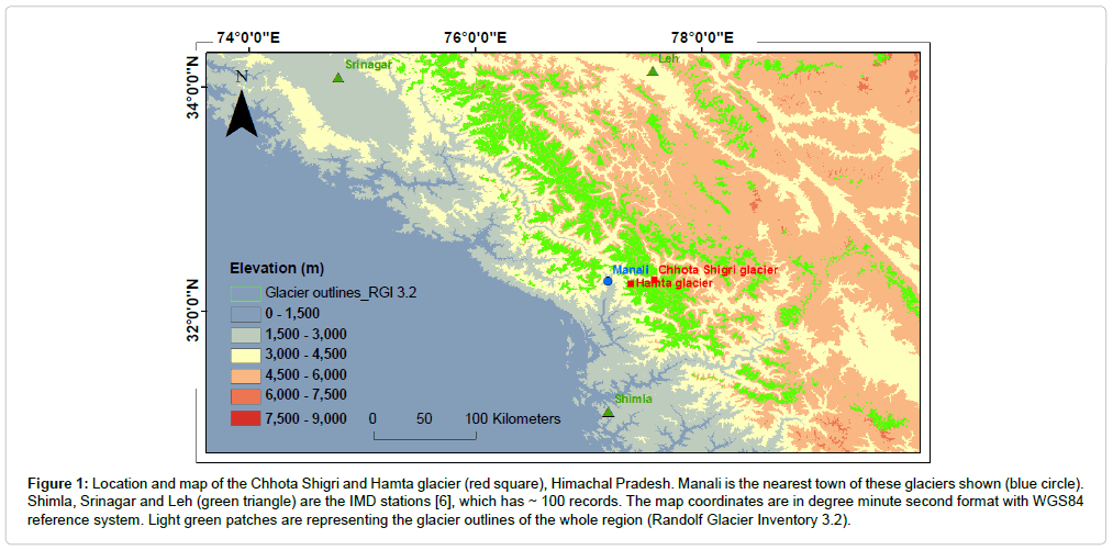
Figure 1: Location and map of the Chhota Shigri and Hamta glacier (red square), Himachal Pradesh. Manali is the nearest town of these glaciers shown (blue circle). Shimla, Srinagar and Leh (green triangle) are the IMD stations [6], which has ~ 100 records. The map coordinates are in degree minute second format with WGS84 reference system. Light green patches are representing the glacier outlines of the whole region (Randolf Glacier Inventory 3.2).
Chhota Shigri is a valley-type glacier oriented roughly north–south in its ablation area, and has a variety of orientations in the accumulation area. It is included in the upper basin of the Chandra River, contributing to the Chenab River, one of the tributaries of the Indus river basin [18]. This glacier is located in the monsoon–arid transition zone and is influenced by two atmospheric circulation systems: the Indian summer monsoon during summer (July-September) and the Northern Hemisphere mid-latitude westerlies during winter (January-April) [25,26]. Its snout is well defined, lying in a narrow valley and producing a single proglacial stream. The lower ablation area (20]. The debris layer is highly heterogeneous, from silts measuring a few millimeters to big boulders sometimes exceeding several meters. The Equilibrium Line Altitude (ELA) for a zero net balance is close to 4900 ma.s.l. [18].
Hamta glacier is about 5.5 km long, and has an area of 3 km2. It flows to the north spanning an elevation range of 4650-4100 m. It has a high and wide headwall that rises steeply more than a kilometer from the top of the glacier. 73% of the total glacier surface area is under a debris mantle [27]. The reported values of recent Accumulation Area Ratio (AAR) for this glacier are 0.1 [19] and 0.15 ± 0.06 [28-32].
Data Sets
Various published datasets such as glacier surface mass balance, length change, ice velocity etc. have been used to understand the relation of these glaciers with changing pattern of climate.
Chhota Shigri glacier
In 2002, a long-term monitoring program was initiated on Chhota Shigri glacier with respect to mass balance, ice velocity, hydrology etc by joint collaboration of JNU, India and IRD, France [18,28]. In the study they have characterized the glacier dynamic behavior and state e.g., annual surface mass balance, annual surface velocity, mass balance gradient etc. [18]. Till date most of the hydrological years are found to be negative. They have also analyzed mass balance gradient with respect to altitudinal change and they have established that this glacier is similar to mid-latitude glaciers, with an ablation season limited to summer months and a mean vertical gradient of mass balance in the ablation zone (debris-free part) of 0.7 m w.e. (100 m)-1, similar to those reported in the Alps. One of the major finding of the study was observation of a differential mass balance pattern over glacier surface, thick cover of debris resist melting. Mass balance is strongly dependent on debris cover (thick debris significantly protects the lowest part of the glacier from melting), on exposure and on the shading effect of surrounding steep slopes. This suggests that melting is likely to be predominantly driven by incoming solar radiation which is irregularly absorbed by the glacier according to surface albedo (snow or ice, presence of debris or not) [18] and also by surface temperature of ice.
Studies followed by, [20,29] further investigated the dynamic behavior of this glacier in detail. Annual mass balance of Chhota Shigri glacier was negative -0.58 ± 0.40 m w.e.a-1 during 2003 to 2011 revealing strong unsteady-state conditions over this period. Available glaciological mass balance series of this glacier has been shown in the Figure 2. To find out the thickness of the glacier ice, 5 transverses cross sections along the flow were obtained using Ground Penetrating Radar (GPR). The cross sections obtained from GPR measurements reveal a valley shape with maximum ice thickness greater than 250 m somewhere towards the middle. The centre-line ice thickness increases from 124 m at 4400 m a.s.l. to 270 m at 4900 m a.s.l. They assessed and concluded that the glacier was in steady-state condition during the past one to two decades preceding 2003/2004 balance year, the glacier-wide mass balance of this glacier has probably been close to zero (the glacier was in more or less equilibrium state). They validated this statement comparing the first observation in 1987/1988 [30] with 2003/2004 iceflux and velocity measurements. They found that since 2003 the glacier ice velocity decreased gradually. On the basis of velocity change they concluded that the ice fluxes have diminished by 24 - 37% below 4750 m a.s.l. between 2003 and 2010.
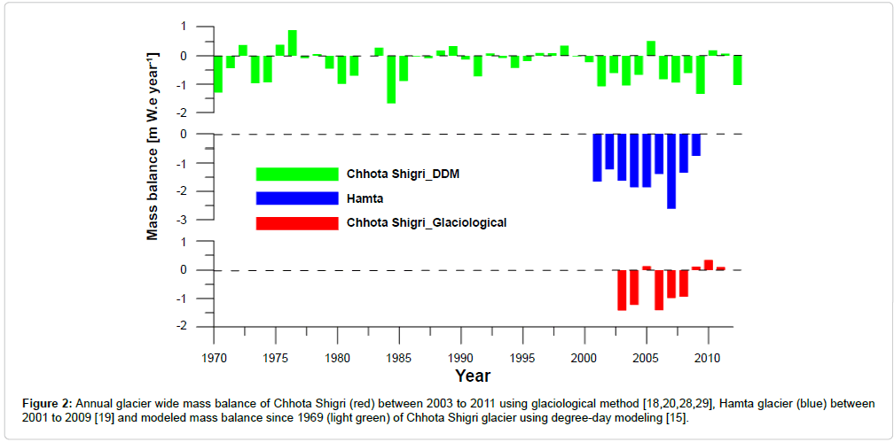
Figure 2: Annual glacier wide mass balance of Chhota Shigri (red) between 2003 to 2011 using glaciological method [18,20,28,29], Hamta glacier (blue) between 2001 to 2009 [19] and modeled mass balance since 1969 (light green) of Chhota Shigri glacier using degree-day modeling [15].
Investigation of geodetic mass balance, surface mass balance, volume change of Chhota Shigri glacier has been carried out between 1988 and 2010 using in-situ geodetic, glaciological and remote sensing measurements [20]. As their surface mass balance study and compilation indicates over the whole period 1988- 2010, the cumulative MB of Chhota Shigri glacier was -3.8 ± 1.8 m w.e., corresponding to a moderate mass loss rate of -0.17 ± 0.08 m w.e. yr-1. In fact, the glacier experienced first a slightly positive or near-zero cumulative MB between 1988 and 1999 followed by a period of ice wastage, confirming the presumption [29]. This glacier has experienced only a slight mass loss over the last 22 yrs (-3.8 ± 1.8 m.w.e.). Using satellite digital elevation models (DEM) differencing and field measurements, they found a negative Mass Balance (MB) between 1999 and 2011 (-4.7 ± 1.8 m w.e.).
To understand the past behaviour at the seasonal, annual as well as decadal levels reconstruction of surface mass balance study was carried out recently [29]. MB series of Chhota Shigri glacier has been extended back(reconstructed) to 1969 by a temperature-index model together with an accumulation model using daily records of precipitation and temperature from Bhuntar Observatory (Himachal Pradesh, ~50 km southwest of Chhota Shigri glacier). Over the study period Chhota Shigri glacier has experienced a moderate mass wastage at a rate of -0.30 ± 0.36 m w.e. a-1. Reconstructed annual mass balance results are shown in Figure 2. This study also suggests that winter precipitation and summer temperature are almost equally important drivers controlling the MB pattern of Chhota Shigri glacier at decadal scale.
Area, length variation study also done using remotely sensed data over Chhota Shigri and surrounding glaciers [3]. They found some interesting results i.e. the glacier has lost an area of 0.47 % during 1980 to 2010 at the rate of 7.73 m year-1. Also the glacier experienced a 17 m upward shift (retreat) of snout (terminus) during 1980 to 2010 (Figure 3a). Sensitivity test of modeled (temperature) based glacier mass balance was performed on Chhota Shigri glacier [15] The sensitivity of mass balance to temperature was -0.52 m w.e. a-1 ºC-1 which corresponds to the highest [48], investigated the meteorological influences on glacier mass balance in High Asia using NCEP/NCAR reanalysis data since 1948.
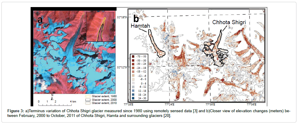
Figure 3: a)Terminus variation of Chhota Shigri glacier measured since 1980 using remotely sensed data [3] and b)Closer view of elevation changes (meters) between February, 2000 to October, 2011 of Chhota Shigri, Hamta and surrounding glaciers [20].
Results indicate modeled mass balance since 1969 of Chhota Shigri glacier, sensitivity to temperature decreases with elevation from -1.21 m w.e. a-1 ºC-1at 4400 m a.s.l. to -0.05 m w.e. a-1 ºC-1 at 6000 m a.s.l. Ablation is primarily controlled by air temperature, and, in turn, in the lower part of the glacier where ablation is predominant, sensitivity of modeled MB to temperature is enhanced. On the debris-covered part (-1 for a 10% change. Hence relation of glacier to air temperature and precipitation suggests temperature is playing a crucial role for melting and governing the annual mass balance.
Hamta glacier
As earlier stated, this glacier is also a well-studied glacier in the Indian side of the Himalaya. Geological Survey of India (GSI) has been monitoring the glacier since 2001 [19]. We have collected the data and compiled it for a holistic study. Compiled datasets are also described in [20,31]. The data shows that the glacier experienced a significant negative mass loss over the past decade (Figure 2). The average annual mass balance of this glacier estimated -1.59 m w.e. year-1 during 2001 to 2009 [19] using glaciological mass balance method. Area and length variation study was carried out for Hamta glacier [3]. Results indicate that, glacier has lost an area of 7.57 % during 1980 to 2010, and retreated at the rate of 16.8m year-1. Also glacier has experienced a 92 m upward shift of snout (terminus). Table 1, represents the total area change since 1963.
| Year | Area calculated from satellite image (sq. km) |
|---|---|
| 1963 | 3.447488 |
| 1989 | 3.141753 |
| 1999 | 3.085437 |
| 2000 | 3.080945 |
| 2001 | 3.076132 |
| 2002 | 3.061785 |
| 2003 | 3.057649 |
| 20040 | 3.053803 |
| 2005 | 3.050559 |
| 2006 | 3.049658 |
| 2007 | 3.046383 |
| 2010 | 3.030846 |
Table 1: Area change of Hamta glacier using remote sensing technique since 1963 [3].
Lahaul-Spiti
2110 km2 of the Lahual-Spiti Himachal Pradesh region is glacierized area with 13 % debris covered [17]. Being one of the largest glaciated areas, many researchers had attempted to study glaciers over this region for their area change, velocity, mass balance, terminus variation, etc. [15,17,18,29,32,33].
A remote sensing based glacier study (thickness and mass) over the Lahual-Spiti region [33]. Almost all glaciers have shown a clear thinning at low elevations, even on debris-covered tongues. Between 1999 and 2004, they obtained an overall specific mass balance of -0.7 to -0.85 m w.e. This rate of ice loss is doubled than the long-term (1977 to 1999) mass balance record for Himalaya.
Mass balance studies over the whole Lahaul-Spiti region between 1999-2011 using remote sensing methods [17] indicates, glaciers of Lahaul-Spiti region have experienced a general and homogeneous thinning over their ablation areas (-0.63 ± 0.05 m yr-1) during 1999 to 2011. They have surveyed mass balance of 8 regions over the Pamir- Karakoram-Himalaya during 1999-2011, out of those 8 regions; Lahaul-Spiti has experienced the most negative mass balance, at -0.41 ± 0.11 m yr-1 w.e. which is a monsoon-arid transition zone.
Another study [20], in the same region showed the mass balance to be -0.44 ± 0.09 m w.e. yr-1 for the same period using remote sensing and geodetic (elevation change) methods. Figure 3b, shows the elevation changes (meters) between February, 2000 to October, 2011 of Chhota Shigri, Hamta and surrounding Lahaul-Spiti glaciers. Also depicts that both glaciers have experienced mass loss with significant rate except some negligible upper altitudinal areas (accumulation) between the study periods.
It shows there is a consistent signal of on-going retreat and down wasting of glacier mass in this region.
Climate Signal
According to the Fourth Assessment Report of the Intergovernmental Panel on Climate Change the global mean surface air temperature increased by 0.74°C while the global mean Sea Surface Temperature (SST) rose by 0.67°C over the last century [25]. Also latest IPCC report has stated global combined land and ocean temperature data shows an increase of about 0.89°C (0.69-1.08) over the period 1901-2012 and about 0.72°C (0.49-0.89) over the period 1951-2012 [24]. If we consider the global climate data to any specific regions then the values may be highly biased especially high topographic regions like Himalaya where the climate behaviours are totally different from the low land areas.
Unfortunately long term Meteorological data are very sparse especially in Himalayan region; also the climatic behaviour in this region is complex. But an attempt has been made [6], to see the trend of the available data from western Himalaya; they have analysed the data from seven stations of Snow and Avalanche Study Establishment, India (SASE) distributed in Himachal Pradesh and Jammu & Kashmir and the three stations of Indian Meteorological Department, India (IMD) i.e. Srinagar, Leh and Shimla. The data time series of IMD stations are close to 100 years long while for SASE observatories the data length varies from 16 years to 22 years. The Temperature trend shows an abrupt rise around mid-sixties with acceleration in the last two decades. The gross rise in mean air temperature in the North West Himalaya in the last two decades is about 2.2°C.
One of the recent studies indicates no trend in the winter precipitation but significant decreasing trend in the monsoon precipitation during 1866 to 2006 over the North West Himalaya. Analysis of the meteorological data from 18 stations of the high altitude observatories of SASE located in different ranges of the Western Himalaya for the period mid-eighties to 2006-07 [23,34]. They found that the seasonal (November-April) mean, maximum and minimum temperatures have increased by about 2°C, 2.8°C and 1°C in about last two decades. Maximum temperature of the Pir Panjal range is increasing at a greater rate than the minimum temperature. Seasonal snowfall has decreased by 280 cm on the Pir Panjal over the period 1988-89 to 2007-08 [35].
Another study [21] about climate change aspects indicate that Pir Panjal range in Himachal Pradesh, maximum increase of 0.7°C, 1.4°C and 0.5°C in mean, maximum and minimum temperature respectively (on wintertime (December-February) data of 30 years (1975-2006)) . It was noted that the spring snow cover area has been declining and snow has been melting faster from winter to spring after mid 1990s over the over the western Himalayas region based on satellite derived data for the period 1986-2000 [36].
Recent study over the Himalayan region with especial focus on Indian Himalaya, results shows that total glacier stored water in the Indian Himalaya is 3600-4400 Gigaton (Gt). Mapping of almost 11,000 out of 40,000 km2 of glaciated area, distributed in all major climatic zones of the Himalaya, suggests an almost 13% loss in area in the last 4-5 decades. This again confirms that the glaciers in the Himalaya at retreating phase. In the last four decades loss in glacial ice has been estimated at 19 ± 7 meters. This suggests loss of 443 ± 136 Gt of glacial mass out of a total 3600-4400 Gt of glacial stored water in the Indian Himalaya. This study has also shown that mean loss in glacier mass in the Indian Himalaya is accelerated from -9 ± 4 to -20 ± 4 Gt year-1 between the periods 1975-85 and 2000-2010 [37,38].
Preview of last decade weather signal
It has been observed that, mean annual temperature of India were above the average for the period 2004 to 2012 (Table 2). The year 2009 was ranked among the top five warmest years since the beginning of instrumental records about 1850, while the decade from 2000 to 2009 has been the warmest on record [37]. 2010 was the warmest year since 1901 for the whole country [39-47]. Climate of high mountainous region shows both spatial and elevation variability, it require dense network as compare to other areas to understand the climate behaviour. However, with the available datasets of IMD stations in Himachal Pradesh, it has been observed that for a period 2005 to 2012 there was a huge variability in the rainfall (Table 2). Almost in every season rainfall is departing from its normal for the whole period.
| Year | Temperature above average since 1901 | Winter season rainfall depletion (%DEP) | Pre-monsoon season rainfall depletion (%DEP) | Monsoon season rainfall depletion (%DEP) | Post-monsoon season rainfall depletion (%DEP) | Annual rainfall depletion (%DEP) |
|---|---|---|---|---|---|---|
| 2004 | 0.47°C | |||||
| 2005 | 0.37°C | 2 | -44 | -8 | -99 | -21 |
| 2006 | 0.59°C | -48 | -41 | -24 | -45 | -32 |
| 2007 | 0.55°C | -38 | -11 | -36 | -77 | -34.8 |
| 2008 | 0.39°C | -20 | -59 | -5 | -51 | -20.8 |
| 2009 | 0.91°C | -51 | -46 | -34 | -36 | -39 |
| 2010 | 0.93°C | -46 | -36 | 13 | -18 | -8 |
| 2011 | 0.45°C | -32 | -32 | -11 | -83 | -23 |
| 2012 | 0.49°C | -9 | -51 | -16 | -62 | -25 |
Table 2: Showing the last decade average temperature anomaly for whole country at annual level and rainfall departure in Himachal Pradesh at seasonal and annual level. Data source IMD annual climate summaries [39-47].
Representativeness Of Chhota Shigri And Hamta Glacier For Lahaul-Spiti Region
Himalayan glaciers are poorly sampled [33] in consideration to time and space. Further in this region the climatic series (temperature and precipitation) are rare and the climate change signal is not clear [22]. Very less glaciers mass balance data are available in literature from this region as well as whole Indian Himalayan glaciers. Data scarcity is due to accessibility and other factors. So, due to limited data and information of glaciers of this region, we have taken these two glaciers as base (or representative) glaciers (in terms of data).
A regional representativeness characteristic of the Chhota Shigri glacier has also been discussed [33]. Further representativeness of this glacier for whole Lahaul-Spiti was established [20], a good agreement between glaciological mass balance and the regional ICESat-deriverd cumulative mass balance between fall 2003 and fall 2008 [16].
Debris Role On Annual Mass Balance
As already mentioned, both the glaciers are covered by supra-glacial debris. In Himalayan region debris covered glacier concentration is very high. 36% of the total glacier area is covered by debris in Central Himalaya (South) and 21% in Western Himalaya [32]. It is now well established that, debris cover plays a very important role on mass balance. Very thick debris check the melting of ice, because, solar radiation cannot penetrate a very thick debris layer and insulation effect dominates and if debris thickness is less than ~2-4 cm it enhances the melt rate [18,20,29,32]. Previous observations [18] indicate that debris at lower part of the glacier efficiently protects the glacier from melting. At 4360 m a.s.l. where two stakes were located on and outside the ~1 to 2 cm thick debris-covered area (thin debris of a few millimetres mixed with isolated rocks sometimes bigger than a few tens of centimetres), the measured mass balance was systematically -1.4 to 2 m w.e. more negative on the debris-free area than over the covered part. Mass balance is strongly dependent on debris cover depending on nature and thickness of debris.
Discussion And Conclusion
Above discussed findings, arguments and information’s about glaciers and changing pattern of climate strongly supports the imbalanced health of Lahaul-Spiti glaciers as well as the western Himalayan glaciers. Most of the study attempted in Lahaul-Spiti (western Himalaya) till date showed a consistent sign of retreating phase [17,18,20,32,33].
In the past decade, almost every year glaciers have experienced negative mass budget (Figures 2 and 4). However error assessment of the measurements should be mentioned for better correlations. Uncertainty assessed mass balance data are available for Chhota Shigri glacier [20,29]. In case of Hamta glacier, mass balances are negative all the time and sometimes high. One of the possible reason, may be the glacier was probably surveyed only in their lower part (which is not always clearly mentioned in sources), making the glacier-wide mass balance biased negatively [20]. For this glacier, geodetic mass balance was of -0.45 ± 0.16 m w.e. year-1 during 1999-2011 [20], whereas the glaciological mass balance was -1.46 m w.e. year-1 during 2000-2009 [19].
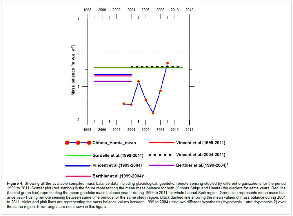
Figure 4: Showing all the available compiled mass balance data including glaciological, geodetic, remote sensing studied by different organizations for the period 1999 to 2011. Scatter plot (red symbol) in the figure representing the mean mass balance for both (Chhota Shigri and Hamta) the glaciers for same years. Red line (behind green line) representing the mean geodetic mass balance year-1 during 1999 to 2011 for whole Lahaul-Spiti region. Green line represents mean mass balance year-1 using remote sensing between same time periods for the same study region. Black dashed line showing the mean values of mass balance during 2004 to 2011. Violet and pink lines are representing the mass balance values between 1999 to 2004 using two different hypothesis (Hypothesis 1 and Hypothesis 2) over the same region. Error ranges are not shown in this figure.
In order to get a better comparison of the above reviewed assessments over Lahual-Spiti glaciers, we have compiled and tried to give a linkage to the recent available results of mass balances and weather. Figure 4 showing all the available compiled mass balance data including glaciological, geodetic, remote sensing studied by different organizations [17-20,29,33]. Scatter plot in the Figure 4 represents the mean mass balance of both Chhota Shigri and Hamta glaciers for matching years. More or less similar results have observed during 1999 to 2011 (red and green line; Figure 4) [17,20]. Two hypotheses (Hypothesis 1 and Hypothesis 2 in Figure 4) used to estimate the mass balance over this region between 1999 to 2004 (pink and violet line; Figure 4) [33]. Both the results are quite similar (-0.85 and -0.69 m w.e., Figure 4). However, all the values of mass balance for same years are not corresponding to the geodetic or remote sensing method, but it is clear that the two glaciers are also behaving like other Lahaul-Spiti glaciers with time. Hence, glaciers of Lahaul-Spiti are losing mass.
Based on the above review it has been confirmed that temperature of the Himachal Pradesh region is increasing [6,15,21,23,35], simultaneously the precipitation is decreasing [23,34,36]. Consequently, IMD data for the last decades indicate that temperature also increasing in entire country and there is huge variability in precipitation in Himachal Pradesh (Table 2) [39-48]. Temperature and precipitation are the two main governing factors of the glacier health. Sensitivity test of modeled (temperature index) based mass balance indicates that temperature change has affected prominently on the glacier surface as compare to precipitation. So here we predicted that glaciers of the Lahual-Spiti region are losing mass due to change in weather pattern, especially increasing air temperature which forms the key parameter of glacier change with time.
However, with limited data sets we cannot asses the vivid climate change and its impact on glacier health. Still the various available data sets and information have helped us to identify the significant correlation between the changing weather trends and glacier mass loss, particularly during the past few decades in the Lahual-Spiti region. So, it is essential to have long term glaciological mass balance, geodetic mass balance as well as long-term climate data (from well distributed climate stations network over the glacierized region) to get the inside view of past, present and future climate-glacier interaction.
Acknowledgement
The authors are grateful to all the researchers who have worked and giving valuable inputs to the scientific community. Authors thank Jawaharlal Nehru University, New Delhi, India for providing all the facilities. Authors are thankful to all the lab mates of Lab No-209 & 214 of School of Environmental Sciences, Jawaharlal Nehru University. Authors are thankful to DST, GOI and our collaborators for their support and the anonymous reviewer for his valuable comments.
References
- Palazzi E, von Hardenberg J, Provenzale A (2013) Precipitation in the Hindu-Kush Karakoram Himalaya: Observations and future scenarios. J Geophys Res Atmos 118: 85-100.
- Maharana P, Dimri AP (2014) Impact of initial and boundary conditions on regional winter climate over the Western Himalayas: A fixed domain size experiment. Global and Planetary Change 114: 1-13.
- Pandey P, Venkataraman G (2013) Changes in the glaciers of Chandra-Bhaga basin, Himachal Himalaya, India, between 1980 and 2010 measured using remote sensing. Int J Remote Sensing 34: 5584-5597.
- Raina VK, Srivastava D (2008) Glacier Atlas of India. Bangalore: Geological Society of India, India.
- Sangewar CV, Shukla SP (2009) Inventory of the Himalayan Glaciers: A Contribution to the International Hydrological Programme. An Updated Edition. Kolkata: Geological Survey of India, India.
- Bhutiyani MR, Kale VS, Pawar NJ (2007) Long-Term Trends in Maximum, Minimum and Mean Annual Air Temperatures across the Northwestern Himalaya during the Twentieth Century. Climatic Change 85: 159-177.
- Bolch T, Kulkarni A, Kääb A, Huggel C, Paul F, et al. (2012) The state and fate of Himalayan glaciers. Science 336: 310-314.
- Immerzeel WW, van Beek LP, Bierkens MF (2010) Climate change will affect the Asian water towers. Science 328: 1382-1385.
- Gardner AS, Moholdt G, Cogley JG, Wouters B, Arendt AA, et al. (2013) A reconciled estimate of glacier contributions to sea level rise: 2003 to 2009. Science 340: 852-857.
- Cazenave A, Dieng H, Meyssignac B, von Schuckmann K, Decharme B, et al. (2014) The rate of sea-level rise. Nature Climate Change.
- Farinotti D (2010) Simple methods for inferring glacier ice-thickness and snow-accumulation distribution. ETH ZURICH. DISS. ETH NO 19268. PhD thesis, ETH Zurich, Switzerland.
- Bolch T, Pieczonka T, Benn DI (2011) Multi-decadal mass loss of glaciers in the Everest area (Nepal Himalaya) derived from stereo imagery. The Cryosphere 5: 349-358.
- Kaser G, Cogley JG, Dyurgerov MB, Meier MF, Ohmura A (2006) Mass balance of glaciers and ice caps: Consensus estimates for 1961-2004. Geophy Res Lett 33: 1-5.
- Barnett TP, Adam JC, Lettenmaier DP (2005) Potential impacts of a warming climate on water availability in snow-dominated regions. Nature 438: 303-309.
- Azam MF, Wagnon P, Vincent C, Ramanathan A, Linda A, et al. (2014) Reconstruction of the annual mass balance of ChhotaShigri Glacier (Western Himalaya, India) since 1969. AnnGlaciol 55: 1-12.
- Kääb A1, Berthier E, Nuth C, Gardelle J, Arnaud Y (2012) Contrasting patterns of early twenty-first-century glacier mass change in the Himalayas. Nature 488: 495-498.
- Gardelle J, Berthier E, Arnaud Y, Kääb A (2013) Region-wide glacier mass balances over the Pamir-Karakoram-Himalaya during 1999-2011. The Cryosphere 7: 1263-1286.
- Wagnon P, Linda A, Arnaud Y, Kumar R, Sharma P, et al. (2007) Four years of mass balance on ChhotaShigri Glacier, Himachal Pradesh, India, a new benchmark glacier in the western Himalaya. J Glaciol 53: 603-611.
- Vincent C, Ramanathan Al, Wagnon P, Dobhal DP, Linda A, et al. (2013) Balanced conditions or slight mass gain of glaciers in the Lahaul and Spiti region (northern India, Himalaya) during the nineties preceded recent mass loss. The Cryosphere 7: 569-582.
- Dimri AP, Dash SK (2012) Wintertime climatic trends in the western Himalayas. Climatic Change 111: 775-800 .
- Yadav RR, Park WK, Singh J, Dubey B (2004) Do the western Himalayas defy global warming?.Geophys. Res. Lett. 31: 1-5 .
- Shekhar MS, Chand H, Kumar S, Srinivasan K, Ganju A (2010) Climate-Change studies in the Western Himalaya. Annals of Glaciology 51: 105-112 .
- IPCC: Climate Change (2013)The Physical Science Basis. Contribution of Working Group I to the Fifth Assessment Report of the Intergovernmental Panel on Climate Change. Cambridge University Press, Cambridge, UK and New York, NY, USA.
- IPCC: Climate Change (2007)The Physical Science Basis. Contribution of Working Group I to the Fourth Assessment Report of the Intergovernmental Panel on Climate Change. Cambridge University Press, Cambridge, UK and New York, NY, USA.
- Bookhagen B, Burbank DW (2010) Toward a complete Himalayan hydrological budget: Spatiotemporal distribution of snowmelt and rainfall and their impact on river discharge. J. Geophys. Res. 115: 1-25 .
- Scherler D, Bookhagen B, Strecker MR (2011) Hillslope - glacier coupling: the interplay of topography and glacial dynamics in High Asia. J. Geophys. Res. 116: 1-21 .
- Ramanathan, AL (2011) Status Report on ChhotaShigri Glacier (Himachal Pradesh). Himalayan Glaciology Technical Report No.1: 1-88 .
- Azam MF, Wagnon P, Ramanathan A, Vincent C, Sharma P, et al. (2012) From balance to imbalance: a shift in the dynamic behaviour of ChhotaShigri Glacier (Western Himalaya, India). J. Glaciol. 58: 315-324 .
- Dobhal DP, Kumar S, Mundepi AK (1995) Morphology and glacier dynamics studies in monsoon-arid transition zone: an example from ChhotaShigri glacier, Himachal Himalaya, India. Current Sci. 68: 936-944 .
- Banerjee A, Shankar R (2014) Estimating the avalanche contribution to the mass balance of debris covered glaciers. The Cryosphere Discuss 8: 641-657 .
- Scherler D, Bookhagen B, Strecker MR (2011) Spatially variable response of Himalayan glaciers to climate change affected by debris cover. Nat. Geosci. 4: 156-158 .
- Berthier E, Arnaud Y, Kumar R, Ahmad S, Wagnon P, et al.(2007) Remote sensing estimates of glacier mass balances in the Himachal Pradesh (Western Himalaya, India). Remote Sens. Environ. 108: 327-338 .
- Bhutiyani MR, Kale VS, Pawar NJ (2010) Climate change and the precipitation variations in the northwestern Himalaya: 1866-2006. Int. J. Climatol. 30: 535-548 .
- DST (2012) Dynamics of Glaciers in the Indian Himalaya: Science Plan. Department of Science and Technology, New Delhi, Himalayan Glaciology Technical Report No. 2: 1-125.
- Kriplani RH, Kulkarni A, Sabade SS (2003) Western Himalayan snow cover and Indian monsoon rainfall: A re-examination with INSAT and NCEP/NCAR data. TheorApplClimatol 74:1-18 .
- WMO (2010) WMO Statement on the Status of the Global Climate in 2009. WMO No. 1055, Geneva, Switzerland.
- Kulkarni AV, Karyakarte Y (2014) Observed changes in Himalayan glaciers. Current Sci. 106: 237-244 .
- IMD (2004) Annual Climate Summary 2004. Issued by Additional Director General of Meteorology (Research), India Meteorological Department, Shivajinagar, India.
- IMD (2005) Annual Climate Summary 2005. Issued by Additional Director General of Meteorology (Research), India Meteorological Department, Shivajinagar, India.
- IMD (2006) Annual Climate Summary 2006. Issued by Additional Director General of Meteorology (Research), India Meteorological Department, Shivajinagar, India.
- IMD (2007) Annual Climate Summary 2007. Issued by Additional Director General of Meteorology (Research), India Meteorological Department, Shivajinagar, India.
- IMD (2008) Annual Climate Summary 2008. Issued by Additional Director General of Meteorology (Research), India Meteorological Department, Shivajinagar, India.
- IMD (2009) Annual Climate Summary 2009. Issued by Additional Director General of Meteorology (Research), India Meteorological Department, Shivajinagar, India.
- IMD (2010) Annual Climate Summary 2010. Issued by Additional Director General of Meteorology (Research), India Meteorological Department, Shivajinagar, India.
- IMD (2001) Annual Climate Summary 2011. Issued by Additional Director General of Meteorology (Research), India Meteorological Department, Shivajinagar, India.
- IMD (2012) Annual Climate Summary 2012. Issued by Additional Director General of Meteorology (Research), India Meteorological Department, Shivajinagar, India.
- Rasmussen LA (2013) Meteorological controls on glacier mass balance in High Asia. Ann Glaciol 54: 352-359.
Citation: Mandal A, Ramanathan AL, Angchuk T (2014) Assessment of Lahaul- Spiti (western Himalaya, India) Glaciers- An Overview of Mass Balance and Climate. J Earth Sci Climat Change S11: 003. DOI: 10.4172/2157-7617.S11-003
Copyright: © 2014 Mandal A, et al. This is an open-access article distributed under the terms of the Creative Commons Attribution License, which permits unrestricted use, distribution, and reproduction in any medium, provided the original author and source are credited.
Select your language of interest to view the total content in your interested language
Share This Article
Recommended Journals
Open Access Journals
Article Tools
Article Usage
- Total views: 18355
- [From(publication date): 0-2014 - Sep 01, 2025]
- Breakdown by view type
- HTML page views: 13451
- PDF downloads: 4904