Assessment of Socio Economic Vulnerability to Flooding in Mweniyumba Neighbourhood, Karonga Township
Received: 08-Feb-2021 / Accepted Date: 12-Mar-2021 / Published Date: 17-Mar-2021 DOI: 10.4172/2573-458X.1000207
Abstract
This study assessed the socio economic vulnerability to floods and its impacts on livelihoods of people based on a modified combination of the Sustainable Livelihoods Conceptual Framework by Department for International Development (DFID) in Mweniyumba Neighborhood by using a survey of 350 households and Focus Group Discussions. The social economic vulnerability analysis focused on exposure, sensitivity and adaptive capacity to floods. Vulnerability at the household level was assessed using drivers of flood vulnerability; these were (i) access to land,(iii) Main source of income (iv) type of house, (v) household assets, (vi) demographic composition of household, (vii) occupation of household. The analysis of flood vulnerability in Mweniyumba shows that access to agricultural land is the most important factor in determining the households’ ability to respond to floods and sustain their livelihoods. The study has revealed that different socio-economic groups implement different coping and adaptation measures because of their differential access to livelihood assets. To reduce vulnerability to floods in Mweniyumba Neighbourhood, the study suggests that the adaptation strategies to be promoted should be those that can be accessible and adopted by the community. Specific emphasis should be given to the improvement of women’s welfare through better access to productive assets and resources
Keywords: Socio economic vulnerability; Floods; Adaptation measures; Livelihood assets
Introduction
Environment is a self-sustained system of all living and non-living things occurring naturally on earth in which living components interact among themselves and with non-living components in the presence of solar energy, without human intervention. Any kind of deterioration of environment either through depletion of resources or adding undesirable substances into it resulting in destruction of habitats and loss of biodiversity is considered environment degradation and it affects sustainable development [1]. From a longer term perspective, the evolution of social, economic and ecological systems within a larger, more complex adaptive system, provides useful insights regarding the integration of the various elements of sustainable development [2]. Two broad approaches are relevant for integrating the economic, social and environmental dimensions of sustainable development. The environmental interpretation of sustainability focuses on the overall viability and health of ecological systems – defined in terms of a comprehensive, multiscale, dynamic, hierarchical measure of resilience, vigour and organisation. Natural resource degradation, pollution and loss of biodiversity are detrimental because they increase vulnerability, undermine system health, and reduce resilience [3]. To minimize these impacts, adaptation to climate variability and changes in the environment is key. Land degradation leads to natural hazards like floods.
Flooding is one of the major natural hazards which disrupt the prosperity, safety and amenity of human settlements and it occurs in a continuous process and in different magnitudes and Sub Saharan Africa remains one of the most vulnerable to floods [4]. Vulnerability can adequately be characterized considering its major components, including exposure, susceptibility and capacity of response in a dynamic process [5,6]. Understanding the vulnerability of varying socio-economic groups at risk before, during and after a particular disaster are critical activities for developing an appropriate disaster risk reduction strategy [7]. Consequently, rural livelihood options are becoming limited and many
People are migrating to urban areas in favour of more diverse and sustainable livelihood opportunities (World Population Review, 2016 [8]. However, adaptive capacity to extreme weather events in urban sub-Saharan Africa is poor [9].
Malawi experiences several natural hazards with severe impacts on the economy and livelihoods. The direct cost of droughts and floods is about 1.7% of Malawi’s GDP every year. On average Malawi loses US$9 million or 0.7 percent of GDP each year due to floods [10]. Karonga Town has not only undergone major socio-economic transformations but is also highly affected by disasters. River floods significantly affect human lives, infrastructure and income earning activities in Karonga and have been occurring every rainy season from 2009 to 2018. In such fragile socio-economic conditions where there are groups of people or elements exposed to floods, their susceptible circumstances have also shaped their flood vulnerability [11].
The high exposure of Karonga Township to disasters and other evironment related hazards such as urban flooding, and lake level rise, health risk has sparked the interest of development agencies and research institutions to report evidences of the occurrence of these environmental challenges. For instance, Manda and Wanda, conducted a research study focusing on understanding the capacity of local communities and local government to respond to key hazards and risks. However, there is lack of studies into assessing the vulnerability of different socio-economic groups regarding the impacts of floods on the livelihoods of people in the study area. According to DFID, a livelihood comprises the capabilities, assets and activities required for a means of living. This may influence the effects of physical interventions in order to mitigate flood damage and adaptation to floods in Karonga Township. Thus, the emerging questions are how are the livelihoods of people in Mweniyumba in Karonga Township affected by floods, and which factors have influenced different socio-economic groups in the study area accessing their livelihood resources for coping with and adapting to flood impacts. This paper focuses on assessing the impact of floods on livelihoods and adaptive capacities of people through the sustainable livelihoods framework in Karonga Township.
Assesing vulnerability is expected to contribute to the enhancement of risk reduction strategies, the reduction of susceptibility and also the development of social and climate change adaptation for exposed socio-economic groups as per IPCC.
Since vulnerability research requires an interdisciplinary approach, more emphasis has to be given to understanding and addressing the interrelated dynamics of social structure, human agency and environments [12].
The Study Objectives
To assess socio economic vulnerability to floods and its impacts on livelihoods of people through the sustainable livelihoods framework. The specific objectives of the study were:
i. To assess the socio economic and gender differentiation aspects of vulnerability to floods that affect adaptation of people in Karonga Township.
ii. To understand how response strategies of people at risk, particularly in terms of coping and adaptation processes, are linked to the transforming structures and processes.
iii. To identify and analyse the reactions and capacities of people to deal with floods in relation to their access to livelihood resources
iv. Climate variability and extremes. In this regard, vulnerability is a function of the character, magnitude, and rate of climate variation to which a system is exposed, its sensitivity, and its adaptive capacity
Literature Review
Vulnerability
Climate change and variability is significantly increasing the incidence of extreme weather events globally and changing environments. Not only will global warming cause uncertainty, it will also impact our daily lives differently IPCC 2014, [13]. It contributes to the vulnerability of poor people more especially in developing countries including Malawi. Vulnerability is the degree to which a system is susceptible or unable to cope with the adverse effects of climate change, including climate variability and extremes. In this regard, vulnerability is a function of the character, magnitude, and rate of climate variation to which a system is exposed, its sensitivity, and its adaptive capacity.
However, resource restrictions, conflicting values, ineffective governance, uncertainties, and limited tools for monitoring are all barriers to adaptation to climate related risks like floods. In order to have better and meaningful adaptation programmes, there is need to understand the vulnerabilities of poor people to climate variability and the communities that are susceptible to climate change related hazards like floods [14,15]. The vulnerability of people to floods varies in terms of social stratifiers such as age, gender, education, ethnicity, sexual identity and religious beliefs [16 ,17].
Ayoade opined that floods in the humid tropics are partly or wholly climatologically in nature, this is established by human interference in the hydrological relationship within the watershed which can cause flooding [18]. Vulnerability research focuses on analyses of livelihoods and adaptation [19-21]. It incorporates concepts regarding interactions between social and ecological conditions and the ability of individuals, households and communities to respond to hazards [22].
Ecological Vulnerability is defined as the degradation of biophysical conditions and extrapolates directly from these estimates to the impact of human occupants of a land scape [23-25]. According to Cutter et al. and Downing et al. social vulnerability is partially the result of social inequalities, including individual income, age, gender and characteristics of communities which influence susceptibility of various groups to damage and govern their ability to respond to stresses or shocks [26,27].
Flooding
Flooding occurs when water accumulates in places that are not normally submerged. According to the Food and Agricultural Organization FAO , flood is said to occur when significant amount of water stand at or inundates in a usually dry area and is unwanted for a long period of time. It involves the covering of dry land, settlement, crops and infrastructure and so on, by large volume of water which leads to the destruction of lives and properties [28-30]. Few et al. observed that flooding has been by far the most common causes of long term data of natural disasters worldwide over the past 100 years [31]. In case of Karonga Township, river flooding is also a common problem. Urban floods are one of the most common and widely distributed natural risks for life and property worldwide [32, 33].
Malawi experiences several natural hazards including floods with severe impacts on the economy and livelihoods. However, the underlying risk driving factors: the level of community knowledge and capacity of local communities and local governments to respond are not well understood. In addition, despite a growing trend of urban disasters, the focus of interventions remains rural [34].
Sustainable livelihoods approach
A livelihood is defined as the capabilities, tangible and intangible assets, and activities required for a means of living [35]. A livelihood is sustainable when it can cope with and recover from stresses and shocks and maintain or enhance its capabilities and assets both now and in the future, while not undermining the natural resource base to (DFID, 2000) [36].
The livelihood approach explores people’s livelihoods and their surrounding environment from a holistic and dynamic perspective . Human-induced hazards in the context of socio-economic transformation is defined as a potentially damaging physical event, phenomenon and or human activity which may cause loss of life, injury, damage to physical assets, socio-economic disruption or environmental degradation [37].
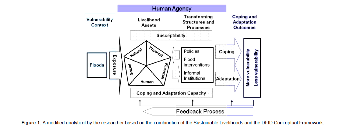
Kollmair et al. the Livelihood framework depicts stakeholders as operating in a context of vulnerability, within which they have access to certain assets. This context decisively shapes the livelihood strategies that are open to people in pursuit of their self-defined beneficial livelihood outcomes [38] .
Elements of the framework: The first element of livelihood framework is the vulnerability context which frames the external environment in which people exist. It highlights how people operate within a vulnerability context that is shaped by different factors – shifting seasonal constraints (and opportunities), economic shocks and longer-term trends.
The second element is the livelihood assets and policies, institutions and processes which have a direct impact upon weather people are able to achieve a feeling of inclusion and well-being. As the livelihoods approach is concerned first and foremost with people, it seeks to gain an accurate and realistic understanding of people’s strengths (here called “assets” or “capitals”) It is crucial to analyse how people endeavor to convert these strengths into positive livelihood outcomes. It therefore shows how people draw on different types of livelihood assets or capital in different combinations which are influenced by: the vulnerability context, a range of institutions and processes and how they use their asset base to develop a range of livelihood strategies to achieve desired livelihood outcomes
The approach is founded on a belief that people require .a range of assets to achieve positive livelihood outcomes.
The fourth element is livelihood strategies and outcomes which are direct dependent on asset status and policies, institutions and processes and income. Hence that poor people compete and that the livelihood strategy of one household might have an impact (positive or negative) on the livelihood strategy of another household.
The livelihood approach provides important points to identify susceptibility and the capacity of different socio-economic groups to respond to hazards [5,39].The vulnerability of a community or a group of people can be seen as a characteristic of social processes which constrain them and keep them from accessing resources required by the group to cope with hazard impacts [40].Therefore, access to key livelihood assets (e.g., agricultural land) or flood-related resources affecting household livelihood strategies as flood adaptation alternatives in the floodplains need to be clarified in the context of the transforming processes and structures. The transforming structures and processes are viewed as driving forces of exposed elements or groups of people vulnerable to hazards.
The household triangle of assets, capabilities and activities lies inside a rectangle which represents earth, the natural resources, and the range of other on- and off-farm resources that people can draw on. People transform their assets and capabilities into livelihood strategies that will meet particular livelihood outcomes. Around the central rectangle is a second rectangle which represents livelihoods outcomes. The more successful the household’s livelihood strategies are, the better the livelihoods outcomes will be. These livelihood outcomes may include greater equity, more income, increased well-being, reduced vulnerability, improved food security and more sustainable use of the natural resource base. Diversification is part of a good livelihood strategy so that the household does not depend on only a few strategies for its survival. More diversification and more sustainable livelihood activities will result in better and better livelihood outcomes .
Sustainable livelihoods framework
(Figure 1).
Research Methodology
Research design
In this study, a mixed method of data collection was used. Tashakkori and Teddlie broadly define the mixed method approach as research in which the investigator collects and analyses data, integrates the findings and draws inferences using both qualitative and quantitative approaches or methods in a single study or a program of enquiry[41] . By mixing the datasets, the researcher provides a better understanding of the problem than if either dataset had been used alone [42] .
Participatory research tools and household surveys were used to explore the main factors influencing flood exposure, flood losses, people’s responses with regard to access to assets, as well as selected indicators for the local vulnerability assessment The purpose of vulnerability aggregation was to identify, understand and visualize varying characteristics of vulnerability as well as major factors shaping flood vulnerability of groups of people in the study area [43].
Study area
The population of Karonga Town is 50,000 and is projected to reach 72,000 by 2029. The town, which covers nearly 4,400 hectares, is located along Lake Malawi at the mouth of the North Rukuru River, within the Karonga Basin, at between 445 and 550 metres above sea level [44].
The research was conducted in GVH Mweniyumba in Karonga Township with a population of 16,250. The area of GVH Mweniyumba contains thirteen smaller villages. The main criteria for research site selection were flood exposure, settlement patterns, and land use change. This research site was an excellent location to examine past flood damage and the flood coping and adaptation processes of local communities in Karonga Township because it is the most vulnerable to floods [45].
Study population
Many households settled in the flood plain of Mweniyumba Neighbourhood in order to access livelihood opportunities (e.g., fishing, off-farm activities and agricultural land), of which access to agricultural land has shaped major sources of household income. The classifications of socio-economic groups in Mweniyumba Neighbourhood were expected to explore major predominant points of livelihoods. For the purpose of this study, major socio-economic groups in Mweniyumba Neighbourhood have been classified by settlement periods; land ownership, main sources of income, wealth and relocation patterns.
Sampling
The target groups, which were identified, based on resettlement periods, land ownership, main income sources, wealth and relocation patterns as well as a result of the literature analysis, provided a framework to select the groups investigated. Households targeted were selected randomly and 350 households were sampled for the study.
Data collection
Quantitative and qualitative tools were used. Household surveys, focus group discussions and observations were employed to collect data. The household survey quantified vulnerability patterns for people from varying socio-economic groups according to specific indicators and the qualitative data aims to clarify the underlying causesof vulnerability of groups of people at risk from floods.
Data analysis
The household survey data was analyzed using SPSS and Microsoft excel. Mean comparison was also used to statistically test the significant difference of major variables (e.g., income, age, education, physical assets, agricultural and residential land ownership) between and within socio-economic groups.
Results and Discussions
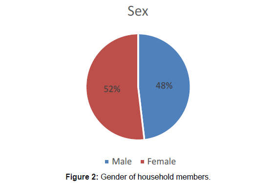
The (Figure 2) reveals that in Mweniyumba Neighbourhood, there are more females than males, 52% to 48% respectively. The majority of these women are poor and are more physically and psychologically exposed to flood risks. However, although poor households are barely exposed and more susceptible to flood risks in Mweniyumba Neighbourhood, a large number of poor households continue to live with floods rather than relocate to higher ground. This is exacerbating their vulnerability to floods
Main sources of household income to cope with floods
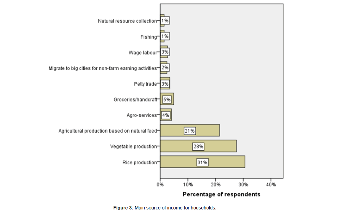
A main source of income expresses flood vulnerability at the household level if it is affected by floods and climate variability in general. In the study area, there are four main types of income-earning sources which come from on-farm activities (e.g. vegetables, rice production and agricultural production based on natural feed), off farm activities (e.g., daily off-farm wage, fishing and natural resources collection), non-farm activities (e.g., business, agro-services and vendors within the village) and remittances (e.g., non-farm activities in cities). These types of main income sources are also closely correlated to agricultural land ownership and household wealth. The study (Figure 3) indicates that most households (59%) in Mweniyumba Neighbourhood relies on-farm activities with rice (31%) and vegetable (28%) production as the main source of income to cope up with floods (Figure 3). It is worth noting that household income which is reliant on only two farming sources of income is a risky livelihood activity in flood situations. This clearly indicates that Mweniyumba Neighbourhood is vulnerable to floods.
The Figure 4 above reveals that the majority of households in Mweniyumba Neighbourhood depend on farming (38.95%) and small scale businesses (24.59%) for their livelihoods. This indicates that the community is highly sensitive to climate variability. There are very few people who have ‘white color’ jobs for their livelihoods. This also is an indication that the study area does not have the adaptive capacity to floods hence vulnerable.
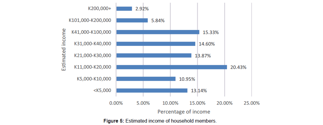
The study revealed that the majority in Mweniyumba Neighbourhood earns an income of below K40, 000 a month (73%) (Figure 5) Only few households are able to earn an income of more than K40,000 to K200,000 (24.09%). This reveals how tough it is to meet all social economic demands for the majority of people who are also vulnerable to flood risks.
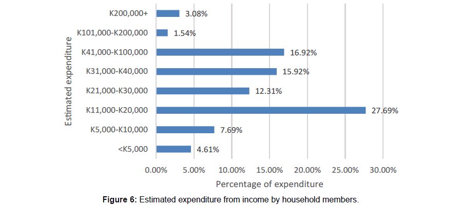
When it comes to spending their income, a combined majority of households 68.22% spend all their income meaning that only 5% is saved (Figure 6) This limits households to cope with floods as they do not have extra money to spend. It also shows that households do not have enough money to invest in infrastructure or household assets.
Assets ownership
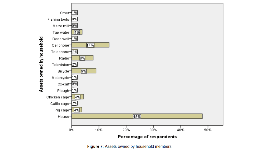
Access to flood-based physical assets such as fishing tools, machines, tap water supplies and means for communications is necessary for flood-affected households to cope with and adapt to annual floods but also the enhancement of household livelihoods. However, the improvement of household assets is shaped by households’ wealth circumstances and livelihood strategies. The study findings (Figure 7), indicate that the most common asset owned by people in Mweniyumba Neighbourhood is a house (48%), and only 26% of the households own communication assets which is a clear indication that only a few people have got the means to access information.
Regarding an increase in water pollution, access to tap water is subject to differentiation within socio-economic groups as well as specific areas. In Mweniyumba, tap water systems are established near the center of town areas which have been settled by migrant households and it is serving only 4% of the population (Figure 7). However people who live far from the center of town (local residents) usually use water from boreholes. This makes households vulnerable to waterborne diseases which as a result of floods. The findings also show that the households in Mweniyumba Neighbourhood have inadequate physical assets that are key to ensuring reduced vulnerability to floods.
Residents with less land for agriculture are exposed to disruption in income-earning activities by floods
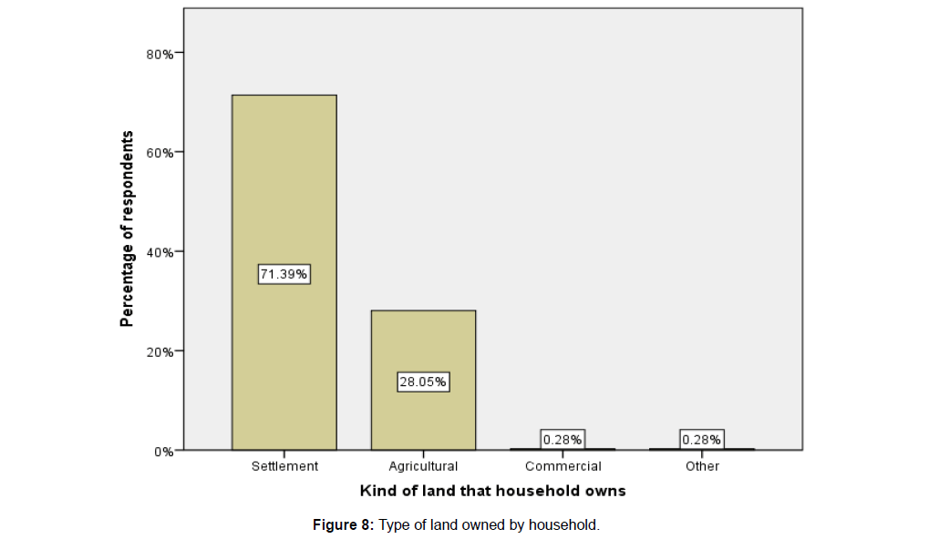
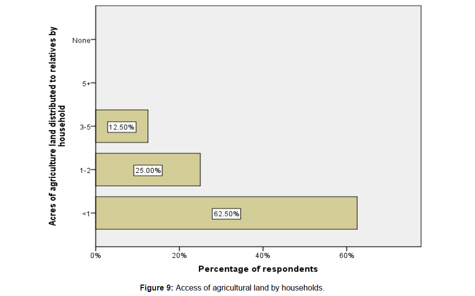
The poor and with less agriculture land not only struggle with flood risks but also disruption of income earning activities. They work in flooding conditions since they usually have little or no agricultural land for on-farm activities and have little access to non-farm jobs (Figure 8). The study findings reveal that only 28% of the households have land for agriculture while the majority (71%) has land only for settlement (Figure 8). In addition the land holding size is very small. The majority (63%) have land less than an acre (Figure 9) for agriculture. As a result, they are significantly exposed to flood risks.
In Mweniyumba Neighbourhood, the main household income comes from off-farm activities and flood-related resources; consequently, when farming activities are disrupted due to floods, off farm wage activities conducted by landless households are also affected. During flooding season poor people lose their main income sources from these off-farm wage activities which narrow their choice for other livelihood opportunities. The decline in flood-related resources has influenced poor residents’ livelihoods in the flood-prone areas. Some of them are still employed through flood-related resources while the others have gradually shifted to non-farm activities in urban areas. This entails how vulnerable the people of Mweniyumba Neighbourhood are to floods.
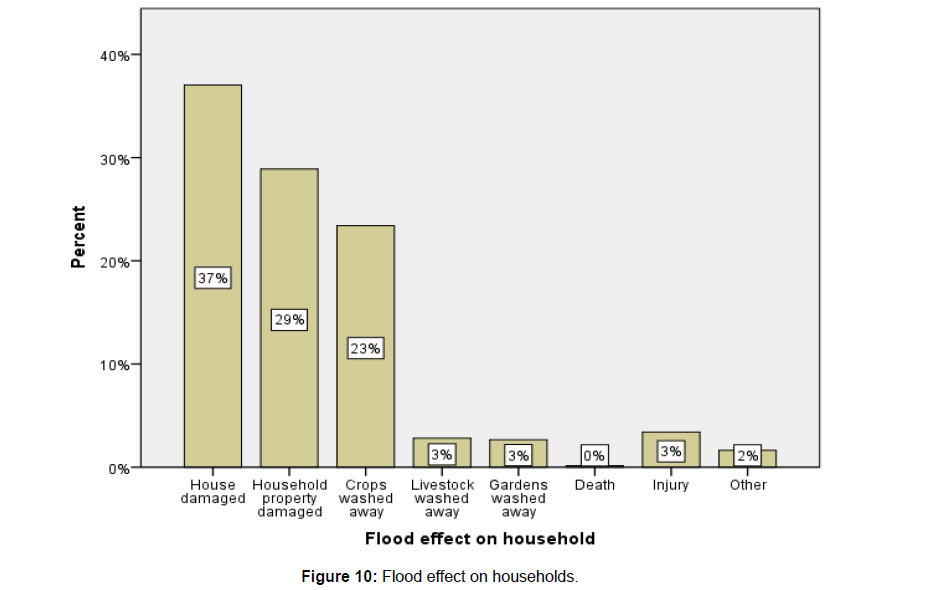
The households were also asked to highlight some of the negative impacts of floods that they have experienced in their communities at household level and at community level ( Figure 10). The results revealed that houses are being damaged (37%) during the time of floods followed by damage to the household property (29%) and then washing away of crops and animals (26%).
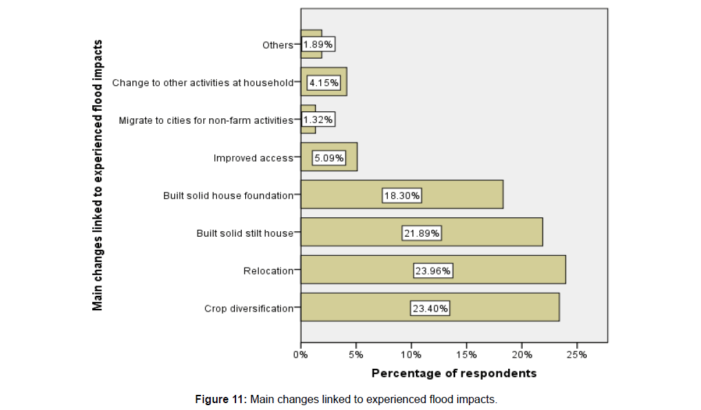
The study asked households to indicate what they have done after experiencing a major flooding event in terms of major changes to their infrastructures and farming as regards to adapting to these adverse events. The results reveal that the households have diversified their crop 23% and animal productions. This is in contrast with the fact they have less land for agriculture. The study revealed that the majority of households have land for settlement and less land for agriculture. This is an indication that even though they have indicated that they are now doing diversified agricultural production, the products may not be adequate to raise income that would made these households to cope and adapt to the adverse effects caused by floods. The study has also shown 24% of respondents indicated that they relocate to safe places when their communities are hit by floods. The results also show that 41% of the respondents indicated that they have prepared their houses to withstand floods (Figure 11). This is a clear indication also that the majority (59%) of people in Mweniyumba Neighbourhood have houses that are not well prepared for floods. This shows that there is a problem of vulnerability of the community and people to floods in the study area.
Positive impacts of flooding
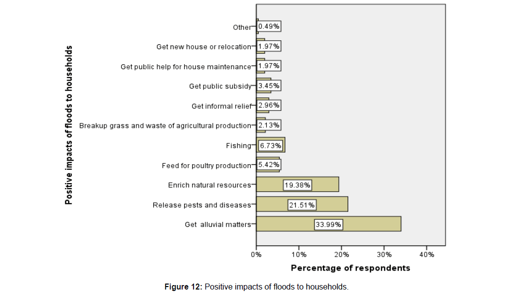
Although severe floods usually cause major damage to crop production, “nice floods” appear to be eagerly welcomed by almost all people in Mweniyumba Neighbourhood, particularly some landowners along North Rukuru River given the benefits to crop cultivation. Local residents indicated that they often benefit from slow onset of floods. They took flood-based food for household consumption (e.g., fish and vegetables). Normally, dependents, such as the elderly, women and children, collected flood-related products for household consumption as well. According to residents in the Mweniyumba Neighbourhood flood plain, flood-related resources are also valuable sources of feed for small-scale livestock and poultry. It was revealed during focus group discussions that when households raised pigs, chickens, ducks or other animals during flooding seasons, they were essentially fed through the flood-related feeds (5.42%). They indicated that flood sediments contribute fertile alluvial materials (33.99%) to the maize and rice fields. The narrative stories indicate that maize and rice crops usually gained high yields after high floods. It was also revealed during discussions that, floods sweep out agro-chemicals, pests (eg; insects and rats) and diseases (21.51%) which cause an increase in both production cost and pesticide concentration in the crop fields. Floods also destroy grasses (2.13%) due to long-term flooding which also reduces production costs. These advantages help to decrease production costs and increase the yields of major successive crops, particularly during crop season. One of the results of flooding was that flood related disasters in the area attracted donors who brought relief to victims (10.35%) (Figure 12).
Negative impact of floods to residents of mweniyumba neighbourhood
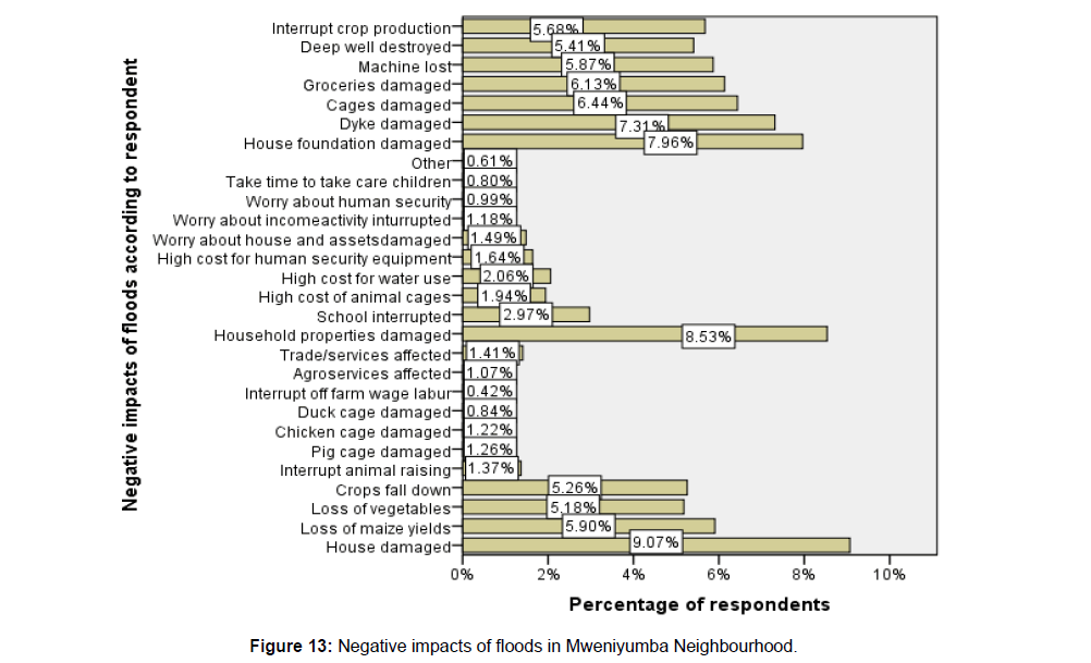
Besides these benefits of floods to the residents of Mweniyumba Neighbourhood, the decline in flood-related resources has significantly influenced rural livelihoods because for example rice-based farming systems have changed and almost all wasteland areas are being cultivated. Therefore, households relying closely on these susceptible resources are more affected by livelihood disruption due to floods. They have faced a decrease in both flood-related income and floodbased foods for household consumption. The interaction between flood-related interventions and flood-related resources has influenced the livelihoods of socio-economic groups differently where women and children in Mweniyumba Neighbourhood have been made vulnerable due to floods. In addition, the study results reveal that during high floods, the public infrastructure and houses located in low-lying places are flooded and damaged (9.07%) and repairs of these infrastructures is very expensive. It was also revealed that physical household assets (e.g., animal cages, machine, deep wells, and food items) are exposed to floods; however, temporary houses and physical household assets in these semi- permanent houses made of unburnt bricks and wood are more susceptible to floods (7.96%). Unfortunately the majority of people in Mweniyumba Neighbourhood are poor (94%). This means that the houses and their physical household assets are exposed to annual slow-onset floods, particular high floods.
In addition to the physical and health dangers related to floods, results of the study reveal (Figure 13) that the affected population experience psychological impact exacerbated by loss of relatives, income-earning activity disruption and the need to repair houses or replace physical household assets (16.71%). During the focus group discussions, it was revealed that mostly poor females were psychologically affected by flood impacts since they were usually responsible for taking care of their children as well as serving daily meals during such hard times. In addition, they also said they were extremely worried about household assets being damaged, and their household members were prone to flood risks. Poor women (52%) faced more difficulties in taking care of food and healthcare responsibilities of borrowing small amounts from money lenders in order to make ends meet. Sometimes poor women and their husbands worked in flooding conditions and were more exposed to water-borne diseases. They usually contracted waterborne diseases during periods of water scarcity and at the beginning and the end of the flooding season.
Negative impacts of flood related interventions adopted by households
The respondents were also asked if the interventions that they are adopting are having any negative impacts on their lives. The majority indicated that the flood related interventions that they are adopting are impacting their lives in a negative way (Figure 14). For instance they indicated that the reconstruction of damaged property due to floods results into high cost of living (15.99%) and also these is also resulting into change of life style (7.40%) which in most cases is in a negative including high daily living cost (17.42%). It is therefore revealed that the coping and adapting mechanisms that are employed impact the lives of the impacted people in the study area and this contributes to an increase in vulnerability.
Coping and adaptation of local communities in the context of slow-onset floods
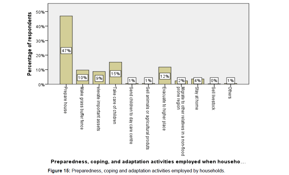
Coping capacity at the household level is necessary to mitigate direct flood impacts. The findings from the study have revealed that the common coping mechanism in Mweniyumba Neighbourhood to floods is preparing or reinforcement of houses (47%) followed by and taking care of children at a kindergarten school (16%) (Figure 15).
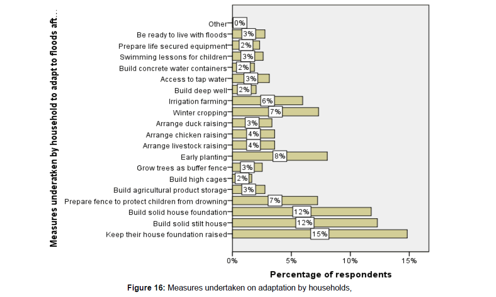
The long history of floods in Mweniyumba Neighbourhood has forced local communities to create a series of adaptation strategies which are applied to adapt to flood impacts and disseminated within the community. It is important to note that, if coping is necessary to respond to flash hazards, adaptation is more suitable for slowonset hazards. In severe flood-prone areas such as in Mweniyumba Neighbourhood, residents have tried to adapt to annual floods. These adaptive responses (Figure 16) include use of hybrid maize varieties (32%), crop diversification (22%), livestock production (3%), improving housing conditions (24%), flood-related forecasts based on local knowledge, flood-related crops, and crop calendar adjustments (43%). In most communities within Mweniyumba Neighbourhood, brick houses with raised foundations are adapted to annual slow-onset floods. Flood forecasting using indigenous knowledge like presence of certain insects or ants.
Decision making at household level on what type of flood coping and adaptation strategy to employ
Of households The study results (Figure 17) show that most decisions on coping and adaptation strategies to floods are done by men (54%). This is a clear indication that women (17.14%) are not empowered in Mweniyumba Neighbourhood and are given very little opportunities to make decisions on issues that affect their lives. Surprisingly the majority of the population in Mweniyumba Neighbourhood are female. The study has already revealed that women are the ones that are more exposed to flood related risks and by not involving them in decision making process is a clear sign that vulnerability.
Conclusion
The livelihood most affected by floods is farming because it is the main livelihood in Mweniyumba Neighbourhood. As most households are heavily dependent on the steady income amassed from rain-fed agriculture, just one disaster of floods can cause an entire loss of a crop and subsequently, their income. Although severe floods usually cause major damage to crop production, “nice floods” appear to be eagerly welcomed by almost all people, particularly landowners in Mweniyumba given the benefits to crop cultivation. The positive impacts of floods to the people of Mweniyumba is that sediments contribute fertile alluvial materials to the rice and maize fields which increase production and reduce production costs. This helps decreases production costs and increase the yields of major successive crops. Given its overall advantages in the Mweniyumba, slow-onset floods are perceived not only as disasters, but also as livelihood opportunities generated by flood-related resources. Local residents indicated that they took flood-based food for household consumption (e.g., fish and vegetables) which helped them to reduce their daily cost of living. Poor people also collected vegetables for household consumption or sale.
Normally, dependents, such as the elderly, women and children, collected flood-related products for household consumption. When households raised pigs, chickens, ducks or other animals during flooding seasons, they were essentially fed through the flood-related feeds.
However, there are negative consequences of floods which include the following: increased costs owing to flood damage and floodrelated interventions, particularly construction of damaged homes and replacement of lost household items. Floods also disrupt sources of income even though the flood impacts differ among varying socioeconomic groups because of their particular exposure, susceptibility and coping and adaptive capacities with the poor are affected the most.
The study has revealed that different socio-economic groups implement different coping measures because of their differential access to livelihood assets. Hence, households classified as poor usually undertake coping activities because of inadequate livelihood assets that would enable them to adapt while wealthier households mainly develop adaptation options, since they have resources to do so. The transforming structures, including relocation, tree planting and agricultural intensification, have impacts on local residents regarding their ability to live with floods. The analysis of different flood patterns and the respective losses and damages in Mweniyumba Neighbourhood revealed that changes in cropping types and strategies and interventions to reduce flood risks, such as crop diversification, house reinforcements and off farm activities are the main drivers for the changes observed in exposure to floods for different socio groups in the study area. These changes are not primarily a result of changing conditions in flood patterns, but rather are determined by socio-economic transformation (e.g. renovation, embankments and agricultural intensification). Indications suggest that flood events are becoming more frequent in Mweniyumba Neighbourhood, and thus the average annual impact might become even greater in the future. It is, therefore, crucial that policy makers take heed of the severe implications of floods, especially for the most vulnerable in society.It is clear from this analysis that flood risks are important; they need to be considered and addressed explicitly in designing and evaluating national development policies and strategies in Malawi. Following this belief,a vulnerability assessment to floods in the context of Karonga Township implies that susceptibility and capacity of response of exposed elements or groups of people should be examined within the transforming structure and process that exist as flood vulnerability partly depends on people’s floodbased livelihoods. Since flood adaptation strategies are developed and enforced through their livelihood resources,an assessment of people’s vulnerability to floods is related to clarifying their level of access to livelihood assets for their adaptation. The significantly different flood damage outcomes experienced by various socioeconomic groups in Karonga Township indicates that many unidentified factors causing human flood vulnerability need to be explored.
References
- Chauhan A (2014) Environmental Degradation & Abrupt Climate Change. International Research Journal of Management Sociology & Humanity (IRJMSH).
- Costanza R, Cumberland J, Daly H, Goodland R, Norgaard R et al. (1997) An Introduction to Ecological Economics. St. Lucia’s Press, Boca Raton FL, USA.
- Munasinghe M, Shearer W (1995) Defining and Measuring Sustainability: The Bio geophysical Foundations, UN University and World Bank, Tokyo and Washington, DC, USA.
- Abdulhamid A, Ibrahim J (2010) A Study of Common Episodic Disaster Events in Zaria Urban Area, Nigeria. Research Journal of Environmental and Earth Sciences 32:Â 90-94.
- Birkmann J (2006) Measuring Vulnerability to Natural Hazards: Towards disaster Resilient Societies. UNU Press.
- Cardona OD (2004) The Need for Rethinking the Concepts of Vulnerability and Risk from a Holistic Perspective: A Necessary Review and Criticism for Effective Risk Management.
- Birkmann J (2006) Measuring Vulnerability to Promote Disaster-resilient Societies: Conceptual Frameworks and Definitions.
- Janzen SA, Carter MR (2013) After the drought: The impact of microinsurance on consumption smoothing and asset protectioN. National Bureau of Economic Research.
- Egondi T, Kyobutungi S, Kovats K Muindi R, Ettarh J, et al. (2012) Time series analysis of weather and mortality patterns in Nairobi’s informal settlements. Global Health Action 5: 23-32.
- Nkoka F (2012) Malawi Country Update, Global facility for Disaster Reduction and Recovery
- Manda MAZ, Wanda EMM (2017) Understanding the nature and scale of risks in Karonga Town, Malawi. Environment and Urbanization 29
- Mclaughlin P, Dietz T (2007) Structure, Agency and Environment: Toward an Integrated Perspective on Vulnerability. Global Environmental Change 39:Â 99-111
- Lee YJ (2015) Climate adaptation planning in coastal areas of Chiayi County, Taiwan. In Proceedings of the International Conference on Energy, Environmental and Sustainable Ecosystem Development (EESED 2015), Kunming, China.
- Vogel C, Brien O, (2004) Vulnerability and Global Environmental Change: Rhetoric and Reality. Information Bulletin on Global Environmental Change and Human Security, Environmental Change and Security Project and the International Development Research Centre, Ottawa.
- FAO (2007) Climate Change and Food Security: A Framework for Action. Report by an Interdepartmental Working Group on Climate Change. FAO Rome.
- Brien O, Sygna K, Leichenko L, Adger R, Barnett WN et al. (2008) Disaster risk reduction, climate change and human security-a study for the Foreign Ministry of Norway. GECHS Project.
- Fordham M, Wisner B, Gaillard JC, Kelman I, (2012) The Routledge Handbook of Hazards and Disaster Risk Reduction. New York: Routledge: 711-722.
- Ayoade JO (1988) Tropical Hydrology and Water Resources, Macmillan Publishers, Ibadan.
- Chambers R, Conway G (1992) "Sustainable rural livelihoods: Practical concepts for the 21st century". IDS Discussion Paper 296.
- Adger WN, Kelly M (2000) Theory and practice in assessing vulnerability to climate change and facilitation adaptation. Climatic Change 47: 325–352.
- Gallopin GC (2006) Linkages between Vulnerability, Resilience and Adaptive Capacity. Global Environmental Change 16 : 293-303.
- Adger WN, Kelly M (1999) Social vulnerability to climate change and the architecture of entitlements. Mitigation and Adaptation Strategies for Global Change4: 253-66.
- Liverman DM (1990) Vulnerability to Global environmental change. In understanding Global Environmental Change, edited by Kasperson RE 27-44 Worcester: Center for Technology, Environment, and Development, Clark University. CC impacts in Nigeria. Journal of Human Ecology, 29:Â 47-55.
- Hewitt K (1995) Excluded perspectives in the social construction of disaster.International Journal of Mass Emergencies and Disasters 13: 317-339.
- Füssel MH (2007) Vulnerability: A generally applicable conceptual framework for climate change research. Global Environmental Change 17: 155–167
- Cutter SL, Mitchell JT, Scott, MS (2000) Revealing the Vulnerability of People and Places: A Case Study of Georgetown County, South Carolina. Annals of the Association of American Geographers 90: 713-37.
- Downing TE, Aerts J, Soussan J, Barthelemy O, Bharwani S, et al. (2005) "Integrating Social Vulnerability into Water Management". SEI Working Paper and Newater Working Paper No 4.
- Frankfort NC, Nachmias D (2004) Research Methods in the social sciences London: ARNOL. Jeb DN (2012). Geospatial Assessment of 2012 Flood Disaster in Nigeria.
- Jeb DN, Aggarwal SP (2008). Flood Inundation Hazard Modelling of the River Kaduna using Remote Sensing and Geographic Information Systems. Journal of Applied Sciences Research, 4: 1822-33.
- Adetunji M, Oyeleye O (2013) Evaluation of the causes and effects of flood in Apete, Ido Local Government Area, Oyo State, Nigeria. Civ Environ Res 3: 19-26.
- Few R, Ahern M, Matthies T, Kovats S (2004) Floods, health and climate change: a strategic review.
- Nasiri H, kalalagh SS (2013) Flood vulnerability index as a knowledge base for flood risk assessment in urban area. J. Novel Appl Sci., 2: 269-72.
- Manda M, Kamlomo D, Mphande D, Wanda E,  Msiska O et al. (2016) Karonga Town: Growth and Risk Profile Working paper # 9
- Chambers R, Conway G (1992) "Sustainable rural livelihoods: Practical concepts for the 21st century". IDS Discussion Paper 296.
- DFID (2000) Sustainable Livelihoods Guidance Sheets. Department for International Development.
- UNISDR (2004) Living with Risk. A Global Review of Disaster Reduction Initiatives. UN Publication, Geneva.
- Kollmair M, Gamper St (2002) The Sustainable Livelihood Approach. Input Paper for the Integrated Training Course of NCCR North-South. Development Study Group. University of Zurich.
- Adger WN (1996) Approaches to vulnerability to climate change. CSERGE Working Papers GEC 96-05.
- Blaikie P, Cannon T, Davis I, Wisner B (1994) At Risk - Natural Hazards, People's Vulnerability and Disasters. London Routledge.
- Tashakkori A, Teddlie C (2009) Integrating qualitative and quantitative approaches to research. The sage handbook of applied social research methods. SAGE Publications, Thousand Oaks.
- Creswell JW, Goodchild L, Turner P (1996) Integrated qualitative and quantitative research: Epistemology, history, and designs. In J Smart 11: 90-136.
- Allen K (2003) Vulnerability reduction and the community-based approach: A Philippines study. Natural Disasters and Development in a Globalizing World edited by M Pelling New York: Routledge: 170-184.
- Coulibaly YJ, Mbow C, Sileshi GW, Beedy T, Kundhlande G, et al. (2015) Mapping Vulnerability to Climate Change in Malawi: Spatial and Social Differentiation in the Shire River Basin. American Journal of Climate Change. 4: 282-294.
- National Statistical office (2010). Malawi National Population and Housing Census, National Statistical office, Zomba.
Citation: Munthali CK, Manda M, Bwanali W (2021) Assessment of Socio Economic Vulnerability to Flooding in Mweniyumba Neighbourhood, Karonga Township. Environ Pollut Climate Change. 5: 209. DOI: 10.4172/2573-458X.1000207
Copyright: © 2021 Munthali CK, et al. This is an open-access article distributed under the terms of the Creative Commons Attribution License, which permits unrestricted use, distribution, and reproduction in any medium, provided the original author and source are credited.
Select your language of interest to view the total content in your interested language
Share This Article
Recommended Journals
Open Access Journals
Article Tools
Article Usage
- Total views: 3801
- [From(publication date): 0-2021 - Nov 21, 2025]
- Breakdown by view type
- HTML page views: 2789
- PDF downloads: 1012
