Conceptual Approach of a Hydrogeological Model for Aquifers in Conflict Zones in Colombia
Received: 12-Jun-2017 / Accepted Date: 06-Dec-2017 / Published Date: 11-Dec-2017 DOI: 10.4172/2157-7617.1000429
Abstract
Groundwater has always been used as an alternative supply to surface water. Normally, the volume of water stored in the aquifers is very large, compared to the recharge flow, this implies that the dwelling time of groundwater in aquifers is much higher than that of surface water in its reservoir (rivers and lakes). The aquifer in Puerto Boyacá, Colombia, is in an area hit by violence following the armed conflict between the National Government and the Revolutionary Forces of Colombia FARC, supplies the municipality of Puerto Boyaca with water, in a high percentage. For this reason, it is necessary to know the aquifer´s behavior through a conceptual approach of the hydrogeological model that governs the water flow, from the identification and evaluation of the main geological, hydrological, and climatic variables; in order to develop a proper monitoring and control of the management and behavior of this aquifer by the environmental authority.
Keywords: Aquifer; Hydrological model; Conceptual approach
Introduction
The Municipality of Puerto Boyacá is in the Department of Boyacá in Colombia. For years, this area, was hit by violence resulting from the deadly war sustained by Colombian government and the insurgent group called: Revolutionary Armed Forces of Colombia FARC.
On the other hand, in a high percentage the consumption of water of its inhabitants, is made through the aquifer that underlies the municipality, and from which it is not specified the extension of this water body that currently has been under exploitation. The recharge zones, water volumes, extraction volumes, recharge volumes, surface sources that support the aquifer´s recharge and possible sources, and vulnerability points to pollution, represent the technical components that support the formulation of a hydrogeological conceptual model, also supported by social, cultural, and economic factors characteristic of a post-conflict zone [1]. In this regard, a general description of the basic geological model of the Puerto Boyacá aquifer will be discussed, and the hydrology of the area will be studied to develop, from these concepts, the conceptual approach of the hydrogeological model which governs this aquifer.
Materials and Methods
Basic geological model
The municipality of Puerto Boyacá is in an area of the basin of the middle valley of the Magdalena River to which two geological and geomorphologically distinct zones belong. Its configuration is continental, with a predominance of sedimentation cycles and tectonism, inside a fractured zone, in which different tectonic and structural styles have been developed. A geological profile developed in a previous investigation from the available information is shown in Figure 1.
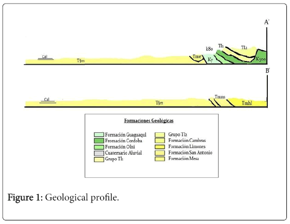
Figure 1: Geological profile.
From the geological and climatic configuration, mountain landscapes, hillsides and alluvial valleys frame the area of study. Geologically, this area is composed by Neogene rocks, covered in large part by recent or Quaternary deposits. The study area consists of sedimentary rocks of the Mesa Formation, alluvial deposits and formations associated with the foothills of the eastern mountain range (Figure 2).
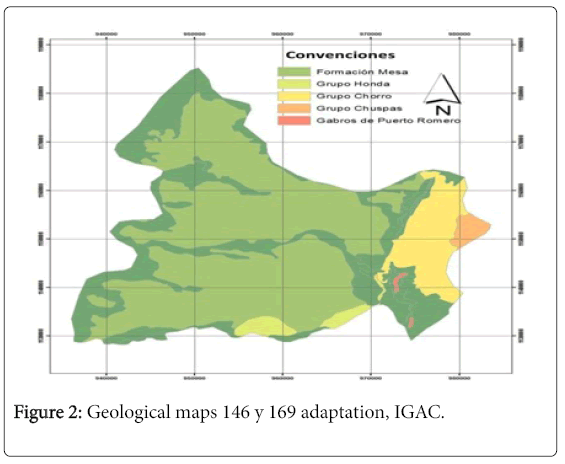
Figure 2: Geological maps 146 y 169 adaptation, IGAC.
The lower part of the Mesa formation is from the lower Pliocene, while the upper part of the Mesa formation may include rocks from Pleistocene, according to De Porta in 1966, as studied by Rodríguez and Solano. This formation is composed of gravel and sand, with intercalations of layers of clays, the gravels are composed of quartz boulders and fragments of sedimentary rocks (mainly chert), metamorphic and a great amount of volcanic rocks. With a thickness of 350 m as per Rodriguez and Solano. The 70% of his unit emerges in the municipality of Puerto Boyacá, acting as a lateral barrier to quaternary deposits at Puerto Boyacá Town Hall (POT) in 2004.
Hydrology of the studied area
For the delimitation of the basins and the calculation of shape parameters thereof, a digital elevation model (DEM) is used (Figure 3).
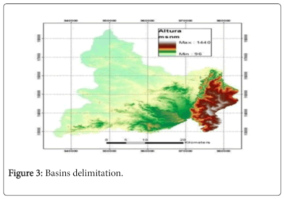
Figure 3: Basins delimitation.
The digital elevation model (DEM) consists of a Georeferenced matrix in which the values of the terrain elevation are stored. Puerto Boyacá is divided into 10 sub-basins, including a small part of the Magdalena River. Figure 4 shows the sub-basins of the study area.
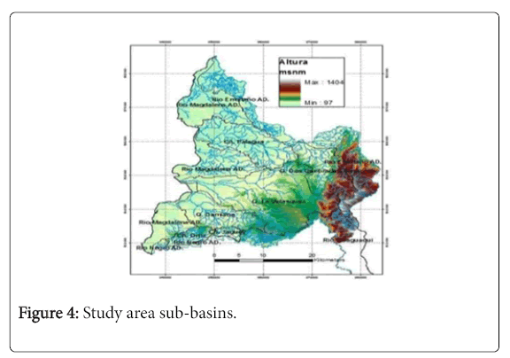
Figure 4: Study area sub-basins.
From the above information, it has been determined that the subbasins are in a warm thermal floor, except for the upper part of four of these 10 sub-basins that exceed 1000 m. Additionally it was determined that the average slopes vary between 4% to 6% indicating that the area is mostly flat.
Several analyzes were conducted toward the statistical characterization of surface water in the basin of study, to understand the sources of admission or recharge of the aquifer that underlies the municipality of Puerto Boyacá. The analysis scale starts from average monthly levels and is summarized at the annual average multi-year scale. The general hydrological study starts from the identification of the geomorphological components of the basin, the characterization of physical variables (eg, precipitation, temperature, surface runoff), and the construction of a water balance model. Based on the information of monthly rainfall, estimated monthly evapotranspiration and average monthly runoff, a water balance on the soil was constructed throughout the study period [2]. This water balance was produced from the model of Thomas [3].
General climatology: The basin of the Magdalena River and other streams are located at an average height above sea level between 97 meters and 320 meters, except for four branches, including Guaguaquí, which approaches 1440 meters above sea level. The climatic classification was carried out applying the criterion of Thornthwaite, which determines two indices for the precipitation and the effective temperature. According to this, and based on the available climatological information of historical records of precipitation and annual average temperature, a humid climate (PE=92.1) is established in the study area with an average annual temperature of 18°C and an average annual precipitation of 1200 mm (Figure 5).
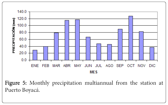
Figure 5: Monthly precipitation multiannual from the station at Puerto Boyacá.
Among other climatic variables, relative humidity adopts a monthly average value of 78.3%, the total number of hours of annual sunshine is 1802 h with a monthly average of 152 h. The vapor pressure of humid air is 12.8 Mb. The average wind speed is 1.9m/s for a wind path 160 km in 24 h.
Direct method of hydric balance: The results show a strong climatic disparity between the different areas of the basin. It is inferred that the lower part of the study basins is affected by higher temperatures that bring as effect, greater evapotranspiration, surpassing the levels observed in the upper part of the sub-basins, in more than 100 mm. For the purposes of applying the balance models, the values produced by the Puerto Boyacá station (23115010) are used, due to their proximity to the hydrometric stations used in the study.
From the results obtained by applying the direct method of the balance model, it is possible to determine that the Magdalena River basin potentially has great storage capacity or flow retention by temporary detentions (e.g. by storage in depressions and by effective infiltration). These estimated preliminary values are specific amounts for Puerto Boyacá climatological station (23115010), which has been valued as a main source of information in the study area, given its proximity to the centroids of each of the sub-basins of analysis.
Thomas balance model: The "abcd" model is a nonlinear basin model which accepts precipitation and potential evapotranspiration as model inputs, producing the magnitude of the flow in the study water stream. Internally the model also represents moisture stored in the soil, underground storage, surface runoff, flows from the aquifers to currents and evapotranspiration. This model originally introduced by Thomas in 1981 and 1983 respectively that is an adequate mathematical structure that allows to evaluate the regional performance of the water resource using a monthly time scale.
This model has been subjected to several comparisons with monthly model of water balance, taking the results to be distinguished by its nonlinear structure of hydrological response. Given the discontinuity in the hydrometric records in the study period, the calibration procedure was performed with two sets of data defined by different time intervals. For the Magdalena River basin, the first calibration scenario is defined in the time horizon from January 1999 to December 2001, and the second scenario from January 2003 to December 2005. The modeling results are moderately acceptable in its generality. The "a" parameter of the Thomas model indicates a low susceptibility of the basin to runoff processes, which should be understood based on the geomorphological characteristics and the vegetation cover of the basin, which favors the development of infiltration processes.
The Magdalena river basin holds a high degree of temporal detention of surface water, evidently indicated in parameter "b" of the Thomas model, a value representative of the watershed's capacity to maintain water within the upper horizon of the soil (e.g. in the unsaturated zone). For the river basin under study the parameter "b" adopts a value of 250 mm. The parameter "c" identifies the proportion of groundwater inputs to surface runoff, which is set at 0.66 for the Magdalena river basin. The parameter "d" shows that the groundwater residence periods in the basin are very high, which leads to a belief that there is a very slow flow of groundwater into the main stream (Figure 6).
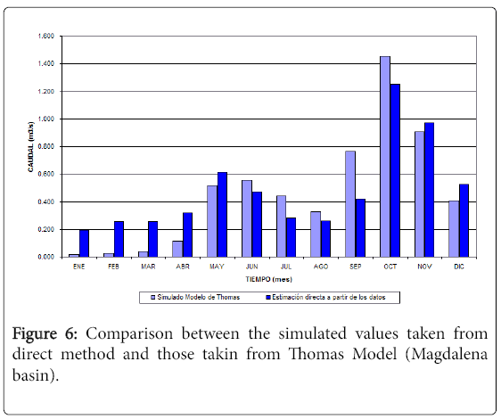
Figure 6: Comparison between the simulated values taken from direct method and those takin from Thomas Model (Magdalena basin).
Hydrogeological model
To develop the conceptual hydrogeological model, a hydrogeological characterization of the geological formations present in the area was established, its lateral and deep distribution was determined, its interrelation with the main bodies of surface water was identified and the available hydrological and hydrogeological information was evaluated (Figure 7).
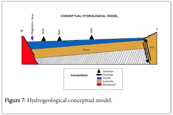
Figure 7: Hydrogeological conceptual model.
Results and Discussion
The recharge has its origin mainly in the direct infiltration of precipitation and the superficial channels that surround the rural plain of the municipality. The conditions of recharge from the Magdalena River are not favorable since the dip of the strata is in the opposite direction to that of the river in direction east-west.
The resulting conceptual hydrogeological model is composed of the gravel and sand levels of the Mesa formation, which has claystone levels at different depths and of different thicknesses. This formation lays over the formation Los Limones considered like an aquitard, forming a lower impermeable limit.
The value of the recharge in mm/month is 193.9. It can be emphasized that the recharge only surpasses the exploitation in the wells in two months of the year, which is not enough to compensate the demand and therefore causes a decrease in the storage of the aquifer, generating the progressive exhaustion of the water reservoir. The discharge of the aquifer appears to the Magdalena river, in the periods in which the level of the river the groundwater wells is low. Finally, the regional flow of groundwater is slow because there is no presence of an extensive discharge zone and a regional geological structure of low dip.
The information provided in relation to the flows granted is based on 14 wells that sums up a value of 15,901 m3/day equivalent to 184 l/s [1]. This value corresponds to the total groundwater demand in accordance with the concessions granted by Corpoboyacá [4,5].
The decrease in the static level (wells) indicates that the annual extraction volume is higher than the recharge, therefore, there is overexploitation, and with the current pumping rate, a sustainable use of the aquifer levels cannot be guaranteed. It is inferred from the water balance that the annual recharge is 128,096 m3, being lower than the annual discharge that is extracted by wells, which is 3,709,850 m3 [1].
Conclusion
By crossing the previous information with the geological information, it can be determined that the effective thickness of the aquifer is approximately 153 m [6], which must be protected due to its overexploitation, through a groundwater management and protection plan [7].
From the formulation of this plan, in a subsequent stage, the development of a methodology [8] that in turn integrates variables associated with climate change, and the social factors in the light of post-conflict, may be initiated, with the purpose of the possibility of answering future questions in the sense of quantitatively assessing the vulnerability of this type of aquifer and its environmental impact.
References
- Monroy ER (2009)ModeloHidrogeológico Conceptual del AcuÃfero de Puerto Boyacá. Intekhnia. Ediciones USTA, Bogotá, Colombia.
- RodrÃguez C, Obregón N, Alarcón M, Monroy E(2010) Formulación Plan de Manejo y Protección del AcuÃfero de Puerto Boyacá. Convenio CORPO- BOYACA Y USTA-TUNJA.
- Thomas HA, Marin CM, Brown MJ,Fierin MB (1983) Methodology for Water Resources Assessment. Report NTIS 84- 124163, US Geological Survey, National. Springfield, Virginia, USA.
- CorporaciónAutónoma Regional de Boyacá (2010) Documentos de ReferenciaAcuÃfero de Puerto Boyacá, Tunja, Colombia.
- Monroy ER (2011) ‘Hydrogeological Model of the Puerto Boyaca’s Aquifer’. ISSN: 2145-9282. IngenioMagno. Universidad Santo Thomas, Tunja, Colombia.
- EmpresasPúblicas de Puerto Boyacá E.S.P (2008) Municipio de Puerto Boyacá. ESP. Municipio de Puerto Boyacá. Colombia.
- Ministerio de Medio Ambiente (2002) Formulación de proyectos de protecciónintegrada de aguassubterráneas - GuÃaMetodológica. Bogotá, Colombia.
- Edgar Ricardo MV, Pouey N (2017) New Environmental Indicator to Support Decision Making. J Climatol Weather Forecasting 5: 188
Citation: Monroy-Vargas ER (2017) Conceptual Approach of a Hydrogeological Model for Aquifers in Conflict Zones in Colombia. J Earth Sci Clim Change 8: 429. DOI: 10.4172/2157-7617.1000429
Copyright: ©2017 Monroy-Vargas ER. This is an open-access article distributed under the terms of the Creative Commons Attribution License, which permitsunrestricted use, distribution, and reproduction in any medium, provided the original author and source are credited.
Select your language of interest to view the total content in your interested language
Share This Article
Recommended Journals
Open Access Journals
Article Tools
Article Usage
- Total views: 4540
- [From(publication date): 0-2017 - Nov 06, 2025]
- Breakdown by view type
- HTML page views: 3650
- PDF downloads: 890