Distribution and Influence of Aspect, Slope and Altitude on Rhododendron arboreumSm. in Shimla District of Himachal Pradesh, India
Received: 15-Sep-2023 / Manuscript No. JESCC-23-113841 / Editor assigned: 18-Sep-2023 / PreQC No. JESCC-23-113841 (PQ) / Reviewed: 02-Oct-2023 / QC No. JESCC-23-113841 / Revised: 22-Jan-2025 / Manuscript No. JESCC-23-113841 (R) / Published Date: 29-Jan-2025
Abstract
Rhododendron arboreum (Ericaceae) is one of the aesthetical, economical and medicinally important plant species to the people of Himachal Pradesh. As the species' distribution has been dwindling year by year, anthropogenic pressure and climate change have put the species very existence in jeopardy. Attempts have been made to study the distribution status effect of topographic factors on the species distribution in order to provide the State Forest Department (SFD) and the think tank with baseline data for research and planning activities related to the species conservation in the wild. A number of factors affect the future of species, and among them, aspect, altitude, and slope are the three fundamental topographic factors that regulate the distribution of vegetation types and their plant composition. The research was conducted in Shimla district of Himachal Pradesh, encompassing seven divisions: Shimla (Rural), Shimla (Urban), Rohru, Chopal, Theog, Kotgarh, and Rampur. The distribution of the species has been examined at 233 different locations using GPS coordinates and other location-specific information like aspect, altitude, slope, and location. A GIS map was created by including all 233 sites that were located using the ArcGIS software. Species were found in 61 locations (Rampur), 40 locations (Shimla-R), 31 locations (Theog), 30 locations (Chopal), 28 locations (Rohru), 21 locations (Kotgarh), 16 locations (Shimla-U), and 6 locations (Shimla Wildlife Forest Division). The study shows that while aspect has little effect on the distribution, altitude and slope act as limiting factors. For its distribution, the species prefers the Northern, 20°-30°, and 2000 m-2500 m categories of aspect, slope, and altitude respectively. The distributional range of the species includes an area of 4745.52 km2 (slope), 3532.16 km2 (altitude), and 4629.6 km2 (aspect), and the active area was estimated to be 3395.33 km2, 2721.54 km2, and 2992.12 km2 respectively. ArcMap 10.4 Geographic Information System (GIS) software was used to create maps showing various studied parameters to show the species' distribution pattern.
Keywords: Anthropogenic; Distribution; Conservation; Regeneration; Rhododendron arboreum
Introduction
The genus Rhododendron is one of the earliest groups of flowering plants that have existed in the northern parts of the world since millions of years. From a historical perspective, its primitive existence can be traced back to south China, which is a confluence of three Chinese provinces, namely Yunnan and Sechuan and Tibet [1] and Yunnan province were regarded as the center of origin in China. In 1753, Carl Linnaeus [2] mentioned the first appearance of the genus in the book 'Species Plantarum' and R. hirsutum is the first species detected by the Flemish botanist Charles I'Ecluse. Sir J. D. Hooker's book 'The Rhododendrons of Sikkim Himalaya' was the first comprehensive work on the genus from India, describes 34 new species from Sikkim Himalaya and provides details of 45 species, including varieties from the Indian region [3] followed by Clark published 46 species of Rhododendron in the 'Indian Rhododendron' in 1882. George Forrest named and identified R. protistum var. giganteum in 1919, one of the tallest and most ancient species in the genus and named it as the 'King of Rhododendron' [4] Rhododendron is a large genus that spans South-Eastern Asia, stretching from the northwestern Himalayas to Northwestern and Northeastern India, northern Myanmar, western and central China and south through Thailand, Vietnam, Malaysia, Indonesia, Philippines Islands, Papua and New Guinea to Australia. The Northwestern Himalayas to Southeastern Asia are where 90% of the species' population is concentrated, with an extension in Nepal and Eastern Tibet, Northern Burma Western and Central China [5]. The Himalayas, Northern and Eastern India, and the hilltops of the Southern Western Ghats in Tamil Nadu and Kerala are where you can find the species in India [6]. According to Sekar and Srivastava [7] the species is primarily concentrated in the following states/UTs: Arunachal Pradesh, Sikkim, Manipur, Meghalaya, Mizoram, Nagaland, Jammu and Kashmir, Uttarakhand, West Bengal, and Himachal Pradesh [8]. The Indian Himalayan Region (IHR) is home to 87 species, 12 subspecies, and 8 varieties of rhododendrons. The western Himalayas are home to the Rhododendron anthopogon, R. arboreum, R. barbatum, R. campanulatum, R. lepidotum, and R. nivale. Four species of the genus Rhododendron, including Rhododendron arboreum (Brash Phool), Rhododendron campanulatum (Kashmiri Patta), Rhododendron anthopogon (Talispatra), and Rhododendron lepidotum (Kashmiri Patta), are found in Himachal Pradesh and have varying economic significance [9]. Among them, R. arboreum is regarded as a prime species because of its high exchange and consumption values. It is a highly prized wild edible flower that grows between 1500 m and 2400 m, commonly known as ‘burans’ [10].
According to Rangaswamy and Sambamurthy [11], the rhododendron plant is known as a ‘mine of phytochemicals’ due to the variety of phytochemical properties that are present in different parts of the plant and have protective or disease-preventive properties. The taxa can be used medicinally for a number of ailments, including cough, cold, chronic bronchitis, asthma, and dysentery [12], antituberculosis properties [13], and other conditions [14]. The corolla of R. cinnabarinum is also used to make jam by head Lamas and Tibetan aristocrats, as well as furniture items like ‘Khukri’ handles, packsaddles, gift boxes, guns-stocks and posts, etc. Shepherds use the wood from R. arboreum, R. barbatum, R. campanulatum, R. hodgsonii, R. ciliatum, and R. cinnabarinum for building and fuel.
Rhododendrons are well-liked for their aesthetic purposes all over the world, and the allure of the genus' fully opened flowers during their flowering season draws in tourists. Nepal's national flower, the Rhododendron arboreum, is shown on its coat of arms. Rhododendron arboreum and Rhododendron campanulatum are the official flowers of Nagaland and Himachal Pradesh, respectively, in India. According to Tewari and Chauhan, the state tree of Sikkim is the Rhododendron niveum, while Uttarakhand's state flower is the Rhododendron arboreu and Chin State, Myanmar's official flower is the Rhododendron niveum. In temples and monasteries, R. arboreum flowers are frequently offered because they are revered. As avenue plantations, hybrids are cultivated in nations like Norway and the USA.
The size and quality of a species' habitat determines how widely distributed it is, but due to human development activities, climate change, and unsustainable harvesting, many species have been forced to localize into tiny niches, disrupting their natural distribution. No matter what forms a species takes (tree, shrub, herb, seedling, or sapling) in a forest or other ecosystem, the distribution of that species is crucial. The larger patterns of distribution of biodiversity in forest ecosystems can be explained by having a thorough understanding of the distribution of different forms and their assemblage. The distribution of different vegetation types in various areas and their plant composition are influenced by a number of factors, including ‘aspect’, ‘altitude’ and ‘slope’. The severe threat faced by several species in their natural habitats has been documented and reported by numerous authors. Any species assessment is a challenging task that can only be accomplished with careful research into its geographic distribution and the creation of a detailed map. Development/framing will benefit from research on the species distribution patterns of Rhododendrons or any other species in a specific area.
Around 25% out of 1157 species in the world are in danger of going extinct in their natural habitat. In India, there are 87 species, and about 50% of them fall into one of three categories: Endangered, rare, or threatened. Due to numerous human development activities and shifting environmental conditions, four species that are found in the state are also in danger and battling for survival. It is crucial to put forth effort in protecting Rhododendron arboreum because it is a keystone species of sub-temperate and temperate region of the state. Therefore, the current study on R. arboreum might serve as an example of how to observe the significance of the species and how to preserve the state's natural resources. It is crucial to understand the distribution of the species in order to determine its status in the Shimla district of Himachal Pradesh, especially in light of the wide range of uses of the species and the various threats that it perceives as a result of deforestation and other anthropogenic development activities.
Materials And Methods
Study area and site location
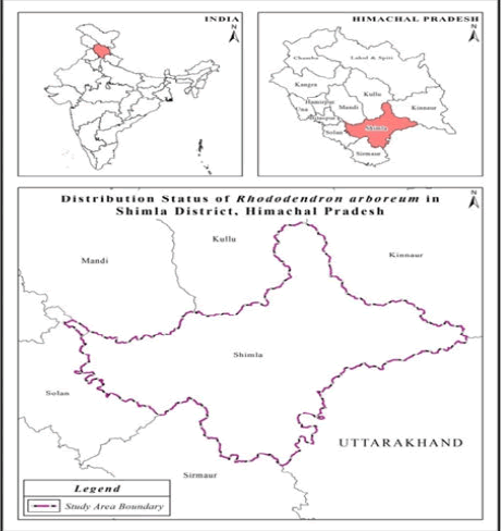
Himachal Pradesh, which covers an area of 55,673 km2 and accounts for about 1.69% of India's total geographic area, is located between 30°22'40" N and 33°12'20" N latitude and 75°45'55" E and 79°04'20" E longitude. Shimla district has a total geographic area of 5,131 km2 and is situated between 76°59'22" and 78°18'40" East longitude and 30°45'48" to 30°43'00" North latitude. The district borders Mandi and Kullu in the North, Kinnaur in the East, Sirmour in the West, Solan in the South-west, and Uttarakhand in the South-east. A number of peaks can be found in the district, including Jakhoo in Shimla town, Siah close to Chail, Churdhar in Tehsil Chopal, Chanshal in Rohru Tehsil, Hattoo in Kumarsain Tehsil, and Shali in Sunni Tehsil. The main river in the study area is the Satluj, which is fed by the Nogali Khad (Figure 1).
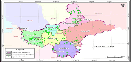
A tributary of the Yamuna river, Pabbar and Giri flow through Rohru forest division. The majority of the terrain is a rough, steep valley with high peaks and dense district forests. The district has cooler winters and moderately warm summers, with an average annual temperature range between -4°C and 31°C and an average temperature of 17°C (winter temperatures ranging from -1°C to 10°C, summer temperatures ranging from 19°C to 28°C). The mean precipitation is 1577 mm. 3,418 km2 of the district's total geographical area is legal forest land, which represents 66.6% and 9.2% of the district's and state's respective geographical areas. Reserved forest measures 53.4 km2, demarcated protected forest 1149 km2 and un-demarcated protected forest 2161 km2. The district of Shimla is divided into three territorial forest circles: Shimla, Rampur, and Wildlife Shimla. Shimla Urban, Shimla Rural, Rohru, Chopal, Theog, Kotgarh, and Rampur are the seven forest divisions in the district. Shimla forest circle includes Shimla (Urban), Shimla (Rural), Rohru, Chopal, and Theog, whereas Rampur Forest Circle includes Kotgarh and Rampur forests divisions (Figure 2). The locations/forests/sites with the noticeably larger concentration of the species were found with the use of ground survey using a variety of methods.
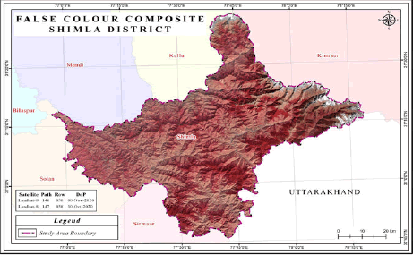
The study sites were stratified using the administrative boundaries of the forest divisions. During this time, all of the forest divisions' administrative borders as well as the limits of the forest rangers were established. Detail information on the species' coexistence with other plants (in this case, Rhododendron arboreum) and the means of access to the forested regions were gathered. Following careful confirmation by the ground personnel of the forest department about the availability of species, the locations were chosen only on the basis of prior knowledge obtained from working plans, compartment history files, and published floras. All of the forest divisions within the Shimla district underwent thorough assessments. Selected sites/patches of R. arboreum were examined for population estimation in accordance with the observed geographic parameters, accessibility, and vegetation structure. The distribution map created by superimposing GPS data over a shapefile is then utilized to extract additional information using online-available satellite imagery data. For the months of October and November 2020, Landsat-8 satellite data were used to create a map showing the species' spread. To create the district's forest cover map (FCM), they were utilized to assemble the False Colour Composite (FCC) picture. From www.earthexplorer.usgs.gov, pertinent Landsat-8 satellite datasets unique to the divisions were retrieved. The chosen time frame was determined with consideration given to the postmonsoon season, which allows for optimal differentiation of various land cover features. The LANDSAT-8 satellite possesses seven optical spectral bands, with a spatial resolution of 30 m × 30 m (Table 1). Three of these bands, namely visible green (0.525 μm-0.600 μm), visible red (0.630 μm-0.680 μm), and near-infrared (0.845 μm-0.885 μm), were utilized to construct a False Colour Composite (FCC) image (Figure 3). In order to improve the interpretation of images, the spatial resolution was augmented by integrating the 8th band (panchromatic, with a spatial resolution of 15 m) with the FCC image. The Digital Image Processing (DIP) was carried out using the ArcGIS and ERDAS Imagine software.
| State | Path | Row | Date of pass | Satellite |
|---|---|---|---|---|
| Himachal Pradesh | 146 | 38 | 08-Nov-2020 | Landsat-8 |
| Himachal Pradesh | 147 | 38 | 03-Oct-20 | Landsat-8 |
Table 1: List of data downloaded and used in the present assessment.
The field surveys yielded distinct measurements of slope, aspect, and elevation of the species, as determined by inclinometer and GPS technology. To ensure accurate species distribution, individual patches were delineated using GPS. The collected data was subsequently converted into a point shape-file and transformed into Keyhole Markup Language (KML).
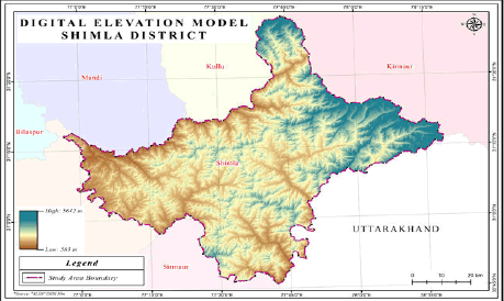
In order to derive elevation classes, Advanced Land Observing Satellite based Digital Elevation Model (ALOS-DEM) data was obtained from http://www.asf.alaska.edu (Figure 4). The various parameters viz. Elevation, slope and aspect were regrouped into different classes/categories are presented below:
| SN | Aspect classes | Elevation classes | Slope classes |
|---|---|---|---|
| 1 | North (0-<22.5, ≥ 337.5-360) | <1000 m | <10° (Gentle slope) |
| 2 | North-East (22.5-<67.5) | 1000-1500 m | 10°-20° (Moderate slope) |
| 3 | East (67.5-<112.5) | 1500-2000 m | 20°-30° (Strong slope) |
| 4 | South-East (112.5-<157.5) | 2000-2500 m | 30°-40° (Very strong slope) |
| 5 | South (157.5-<202.5) | 2500-3000 m | >40° (Steep slope) |
| 6 | South-West (202.5-<247.5) | ||
| 7 | West (247.5-<292.5) | ||
| 8 | North-West (292.5-<337.5) | ||
Table 2: Different classes of various parameters to categorize the obtained data.
The data was categorized according to the classes listed in Table 2, and the area falling under each class were determined independently (according to forest divisions) in order to determine the area under the distributional range of the species in various classes of each category of aspect, slope and altitude.
Results
A comprehensive survey was conducted to investigate the distribution of R. arboreum species in the Shimla district, wherein a total of 233 sites were examined. The survey encompassed 32 forest ranges, 89 forest blocks, and 304 forests falling under these forest divisions (Figure 5).
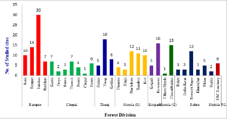
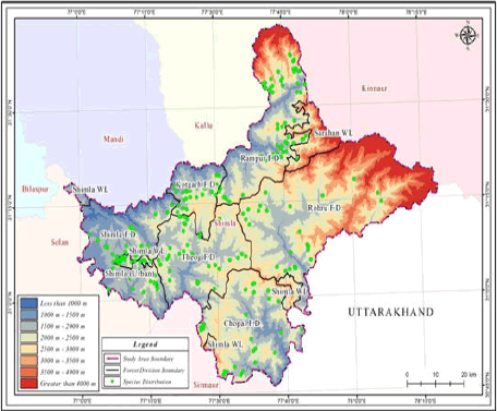
The species was found to be distributed across 30 forest ranges, 71 forest blocks, and 117 forest beats. Of these, a maximum of 61 sites were observed and assessed in the Rampur forest division, followed by 40 in Shimla (rural), 31 in Theog, 30 in Chopal, 28 in Rohru, 21 in Kotgarh, 16 in Shimla (Urban), and 6 in Shimla wildlife. The distribution of the species is predominantly contiguous and patchy, with these patches being randomly distributed. Therefore, the species exhibits a contiguous and random type of distribution at the studied locations (Figure 6).
Within the Rampur division, a maximum of 30 sites were identified in the Sarahan range, while a minimum of 7 sites were located in the Nankhari range. Of the total 30 sites in the Chopal division, a maximum of 7 sites each were discovered in the Kanda and Tharoch Forest ranges, with a minimum of 1 site located in the Chopal forest range. In the Theog forest division, a maximum of 18 sites were marked in the Theog forest range, while a minimum of 8 sites were found in the Balsan forest range. Within the Shimla (R) area, 40 sites were geo-referenced, with a maximum of 12 sites located in the Mashobra forest range and a minimum of 3 sites located in the Bhajji forest range. In the Kotgarh Division, a maximum of 16 sites were located in the Kumarsain forest range, while a minimum of 5 sites were located in the Kotgarh range. In Shimla (U), the species was found in two forest ranges, with 15 sites in the Choura Maidan forest range and 1 site in the Chhota Shimla forest range. Within the Rohru forest division, the species was located in a maximum of 12 sites in the Sarswati Nagar range, 3 sites each in the Rohru, Dodra- Kwar, and Khashdhar ranges, and 2 sites in the Bashla forest range. Finally, 6 sites were located in the Shimla water catchment sanctuary of the Shimla wildlife division (Figure 7).
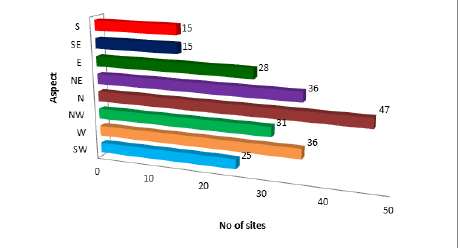
A total of 233 sites/locations within 8 forest divisions were examined in the study area. Upon consideration of aspect, it was observed that R. arboreum exhibits a preference for Western to Eastern aspects (W-N-E), specifically North-Western, North, and North- Eastern aspects, as their preferred habitat. The examined sites demonstrate a notable preference for the Northern aspect, with a maximum of 47 sites, followed by 36 sites each for the Western and North-Eastern aspects, 31 sites for the North-Western aspect, and 28 sites for the Eastern aspect (Figure 8).
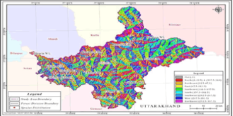
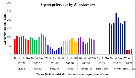
Based on the analysis of the studied sites, the obtained data was subsequently correlated with the distributional ranges of each forest division (Figure 8). The total area encompassed by the distributional range of the species has been determined for all forest divisions, as well as for the study area. The findings of this study indicate that a total of 4629.6 km2 of land in Shimla district falls within the distributional range of R. arboreum, if only aspects are taken into consideration for the species' distribution. According to these estimates, the Rohru and Rampur Forest division cover almost the entire area of the species' distribution, followed by other forest divisions. Therefore, it can be inferred from the results that aspect may not be the limiting factor for the distribution of R. arboreum, but rather, it mostly favors the Northern aspect. The studied sites have been located on the map of Shimla district based on the aspect categories (Figure 9).
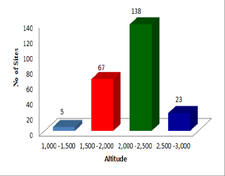
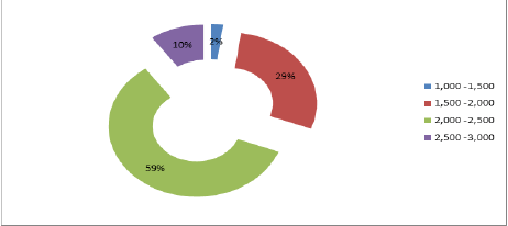
Altitude preferences by R. arboreum in the Shimla district: Upon consideration of the selected sites for the purpose of studying distribution along the altitudinal gradient, it was observed that the overall distribution of the species is limited to the range of 1000-3000 m, with the maximum population being observed within the altitudinal range of 1500-2500 m (Figures 10 and 11). In terms of percentage, it was noted that 59% of the population/sites fall within a single altitudinal zone, specifically the range of 2000-2500 m (Figure 12). These figures indicate that the altitudinal range of 2000-2500 m is the most preferred range for the distribution of R. arboreum.
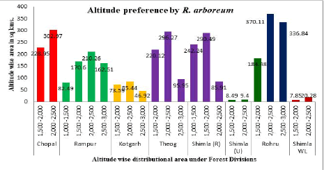
Based on the analysis of the located sites, the distributional range of the species has been determined for all forest divisions and the study area (Figure 10). The findings of this study indicate that, in terms of altitude, an area of 3532.16 km2 in Shimla district falls within the distributional range of R. arboreum. The Rohru forest division has the largest area under the distributional range of the species, with 891.43 km2, followed by Rampur forest division (625.86 km2), Shimla (Rural) forest division (618.64 km2), Theog (612.34 km2), and Chopal forest division (531.92 km2). The remaining three forest divisions have a significantly smaller area under the distributional range. The locations studied have been marked on the map of Shimla district using GPS readings, which clearly illustrate the distribution along the altitudinal gradient (Figure 13). This study concludes that the altitudinal gradient acts as a limiting factor for the distribution of the species. Furthermore, it has been observed that the species does not exhibit any distribution below 1000 m or above 3000 m.
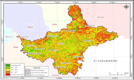
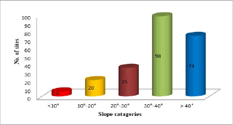
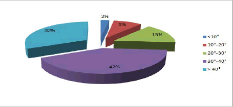
Slope preferences by R. arboreum in Shimla district: All 233 sites that were examined were taken into consideration for the purpose of studying the distribution across the range of slope. It was observed that the species under investigation were distributed across all categories of slope. The highest concentration of population across the studied sites was found in the intermediate ranges of slope, specifically between 20°-40° (Figures 14 and 15). In terms of percentage, it was noted that 45% of the population/sites were observed in a single slope category, namely 20°-30° (Figure 16).
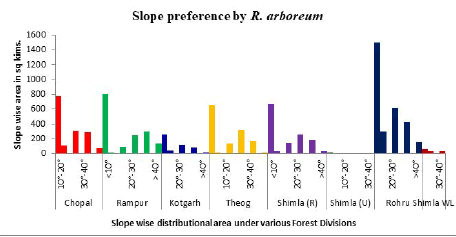
The preferred slope category of R. arboreum has been found to be between 20°-30°, as indicated in the study. The findings of this study reveal that the total area under the distributional range of R. arboreum in Shimla district is estimated to be 4745.52 km2, based on the slope of the study area. Among the forest divisions, Rohru forest division has the largest area of 1499.45 km2 under the distributional range of the species, followed by other forest divisions (Figure 17). The locations studied have been marked on the map of Shimla district using GPS readings, which clearly illustrates the distribution of the species based on slope (Figure 14). These results suggest that slope gradient is a limiting factor for the distribution of R. arboreum.
Discussion
Altitude is a crucial factor in determining the distribution of trees, as it has a direct impact on the microclimate of the habitat. In the Himalayan region, altitude plays a significant role in shaping the physical characteristics, biological diversity, distribution, socioeconomic uses, and consumption patterns of trees.
A comprehensive investigation into the distribution of R. arboreum has not been previously conducted, thus the present study represents the first attempt from Himachal Pradesh to report on the distribution of any Rhododendron species at the district level. The study concludes that the distribution of R. arboreum is influenced by altitude, with the observed distributional range in the study area falling between elevations of 1000-3000 m. The 4th altitudinal zone (2000-2500 m) was found to be the most preferred range for its distribution, followed by the 3rd altitudinal zone (1500-2000 m), as evidenced by the maximum number of recorded sites. In the Uttarakhand Himalayas, the maximum distribution of R. arboreum was reported between an altitudinal range of 1900-2400 m, with a sharp decline below and above this range. The study further reveals that the altitude zone between 1500-2500 m encompasses the maximum number of distributed sites (205 out of the total located sites), accounting for 88% of the total. The findings of the present study are supported by the research conducted, who reported the maximum distribution of R. arboreum population between an altitudinal range of 900-2600 m in the Kedarnath wildlife sanctuary, Western Himalaya.
Aspect is a topographical factor that exerts a significant influence on vegetation structure. Despite this, there is a dearth of specific studies on the distribution of R. arboreum with respect to aspect categories. The present study represents a preliminary attempt to correlate the distribution of R. arboreum with aspect categories. The results indicate that the species is distributed across all aspect categories, and aspect does not appear to be a limiting factor for its distribution. The maximum number of sites (47) was recorded in the North aspect, followed by 36 sites each in the North-eastern and Western aspects, and 31 sites in the North-western aspect. These findings are consistent with earlier studies by Pant and Samant, Nagar et al., Mehta et al., and Malik and Bhatt, which reported the distribution of R. arboreum across various aspect categories.Collectively, these studies suggest that aspect does not significantly affect the distribution of R. arboreum and is not a limiting factor for its distribution.
The slope of a terrain is a crucial factor that directly impacts the diversity of species. The degree of slope determines the amount of water that will percolate into the ground and the amount that will flow downhill towards streams. Additionally, the slope is considered an initiator of erosion and plays a vital role in determining soil erosion in hilly terrain. The present study has revealed that the distribution of R. arboreum is not restricted by any particular slope category. However, the results indicate that the maximum population (45%) of the species is reported in the slope category of 20°-30°, which comprises nearly half of the total studied population/sites/area, followed by the slope category of 30°-40°, which has 27%. The slope ranging between 20°-40° comprises the maximum number of studied sites. Therefore, it can be inferred that R. arboreum prefers strong to very strong slope categories between 20°-40°. Previous studies on R. arboreum have been limited, but Tiwari et al., reported the distribution of R. arboreum in the 23° slope category at Gangi location in Uttarakhand, while Pant and Samant reported the distribution of the species in the slope category of 5°-45° at Mornaula reserve forest. Pant and Samant also reported that the most preferred slope for the distribution of R. arboreum lies between 10°-40° in their studies on the diversity and regeneration of tree species of Khokhan wildlife sanctuary in northwestern Himalaya.
In accordance with topographical determinants, the estimation of the area under the distributional range of a particular species has been conducted within the study area. Geographic Information System (GIS) tools have provided data on various categories of altitude, aspect, and slope, which have been divided accordingly. The area under distributional range based on altitude, aspect, and slope has been found to be 3532.16 km2, 4629.60 km2, and 4745.52 km2, respectively. The active area under distribution of the species can be defined as the area under preferred zones or categories. Therefore, the active area under distribution based on preferred altitude, aspect, and slope has been found to be 2565.2 km2, 2439.45 km2, and 3395.33 km2, respectively. Bhandari et al., conducted a prediction mapping through maxent modelling and reported that an estimated distribution of R. arboreum in Uttarakhand covers an area of 963.62 km2 at an elevation of 2000-2500 m, 846.57 km2 at 1500-2000 m, and 172.65 km2 above 2500 m. A similar study conducted by Shankhwar et al., on Myrica esculenta, one of the associated species of R. arboreum, showed that the highest area under distribution was found at an elevation of 1500-1800 m as compared to higher elevations of 2100-2400 m.
Conclusion
The present study has determined that the distribution of R. arboreum within the district is contiguous and random. The aspect of the terrain does not appear to act as a limiting factor in the distribution of the species, as it has been observed that R. arboreum prefers to grow in a wide range of aspects, with a preference for Western to Eastern aspects, including North-Western, North, and North-Eastern. However, altitude has been identified as a limiting factor, as 88% of the sites where R. arboreum was found were distributed between 1500-2500 m. Therefore, it can be concluded that altitude influences the distribution of R. arboreum in the district. Similarly, slope has also been identified as a limiting factor, as 89% of the sites where R. arboreum was found were distributed between slope categories of 10°-40°. Thus, it can be concluded that slope influences the distribution of R. arboreum in the district. The study has also revealed that more than 80% of the located sites have regeneration of more than 5000 individuals per hectare, indicating good health of the forest and its better existence in the future. Furthermore, 90% of the studied sites have tree density of more than 300 individuals per hectare, indicating a good population size of R. arboreum in the district. The distributional range of R. arboreum has been recorded as an area of 3532.16 km2 as per altitude categories, with an active area of distribution of 2565.2 km2. Similarly, an area of 4629.60 km2 has been recorded under the distributional range of R. arboreum as per aspect, with an active area of distribution of 2439.45 km2. Finally, an area of 4745.52 km2 has been recorded under the distributional range of R. arboreum as per slope category, with an active area of distribution of 3395.33 km2.
References
- de Milleville R (2002) The Rhododendrons of Nepal. Himal Books 136.
- Shen SK, Wu FQ, Yang GS, Wang YH, Sun WB (2015) Seed germination and seedling emergence in the extremely endangered species Rhododendron protistum var. giganteum-the world’s largest Rhododendron flora. Morphol Distrib Funct Ecol Plants 216: 65-70.
- Singh KK, Gurung B (2009) In vitro propagation of R. maddeni Hook. F. an endangered Rhododendron species of Sikkim Himalaya. Notulae Botanicae Horti Agrobotanici Cluj-Napoca 37: 79-83.
- Panda S, Kirtania I (2016) Variation in Rhododendron arboreum Sm. complex (Ericaceae): Insights from exomorphology, leaf anatomy and pollen morphology. Mod Phytomorphol 9: 27-49.
- Sekar KC, Srivastava SK (2010) Rhododendrons in Indian Himalayan region: Diversity and conservation. Am J Plant Sci 1: 131.
- Samant, Pant S, Singh M, Lal M, Singh A, et al. (2007) Medicinal plants in Himachal Pradesh, north western Himalaya, India. Int J Biodivers Sci Ecosyst Serv Manag 3: 234-251.
- Devi S, Vats C (2017) Physico-chemical characteristics of Rhododendron flowers available in different regions of Himachal Pradesh. IJAIR 6: 2319-1473.
- Rangaswami S, Sambamurthy K (1960) Crystalline chemical components of the flowers of Rhododendron nilagiricum Zenk. InProceedings of the Indian Academy of Sciences-Section A. Springer 51: 322-327.
- Laloo RC, Kharlukhi L, Jeeva S, Mishra BP (2006) Status of medicinal plants in the disturbed and the undisturbed sacred forests of Meghalaya, northeast India: Population structure and regeneration efficacy of some important species. Curr Sci 25: 225-232.
- Saklani S, Chandra S (2012) In vitro antimicrobial activity, nutritional profile and phytochemical screening of wild edible fruit of Garhwal Himalaya (Ficus auriculata). Int J Pharm Sci Rev Res 12: 61-64.
- Srivastava P (2012) Rhododendron arboreum: An overview. J Appl Pharm Sci 30: 158-162.
- Tiwari ON, Chauhan UK (2006) Rhododendron conservation in Sikkim Himalaya. Curr Sci. 25: 532-541.
- Ong HG, Ling SM, Win TT, Kang DH, Lee JH, et al. (2018) Ethnobotany of wild medicinal plants used by the Muun ethnic people: A quantitative survey in southern Chin state, Myanmar. J Herb Med 13: 91-96.
- Ashish P, Latif KM, Kumar DA (2010) Effect of stump girth and height on resprouting of Rhododendron arboreum following disturbance in temperate mixed broad leaved forest of Arunachal Pradesh, India. J For Res 21: 433-438.
Citation: Kumar V, Bhondge SW, Sharma R (2025) Distribution and Influence of Aspect, Slope and Altitude on Rhododendron arboreum Sm. in Shimla District of Himachal Pradesh, India. Earth Sci Clim Change 16: 874.
Copyright: © 2025 Kumar V, et al. This is an open-access article distributed under the terms of the Creative Commons Attribution License, which permits unrestricted use, distribution and reproduction in any medium, provided the original author and source are credited.
Select your language of interest to view the total content in your interested language
Share This Article
Recommended Journals
Open Access Journals
Article Usage
- Total views: 685
- [From(publication date): 0-0 - Nov 29, 2025]
- Breakdown by view type
- HTML page views: 566
- PDF downloads: 119

