Earthquake Risks in Bangladesh and Evaluation of Awareness among the University Students
Received: 28-May-2018 / Accepted Date: 10-Jul-2018 / Published Date: 14-Jul-2018 DOI: 10.4172/2157-7617.1000482
Keywords: Earthquake risk; Historical earthquakes; Awareness; University students; Government initiatives
Introduction
Bangladesh, a South Asian country located between 20.35°N to 26.75°N Latitude and 88.03°E to 92.75°E Longitude is well known for various natural disasters. The Asia Pacific Disaster Report 2015 places Bangladesh at the 10th place for exposure to natural disasters and in the 5th place for risk [1]. Every year the country experiences natural disasters like cyclones, floods, droughts, earthquakes, river bank erosions etc. But among those, Bangladesh is more threatened by earthquakes and studies also corroborate this. Bangladesh is surrounded mostly by India and a few by Myanmar and she lies where three tectonic plates-Eurasia, India, and Burma meet making her one of the most tectonically active regions in the world. In the past 200 years, Bangladesh has experienced many devastating as well as mild earthquakes. After the independence in 1971, Bangladesh has been shaken up by more than 250 earthquakes and some of those were greater than 6.0 magnitude. But the risks cannot be ignored [2]. Studies have also shown the possibilities of losses of life [3]. The occurrence of an earthquake in an earthquakeprone region can never be prevented and there is no prior prediction to the earthquake as well but by studying critically, issue warning, implementing the management techniques of settlements for both predisaster preparedness and post-disaster management, we can minimize the losses of lives and properties. Even the Government of Bangladesh understands this and in the recent years, many awareness growing campaigns have been organized (Figure 1).
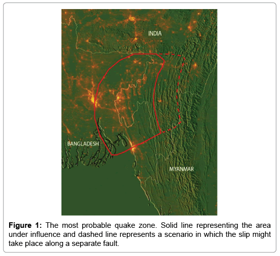
Figure 1: The most probable quake zone. Solid line representing the area under influence and dashed line represents a scenario in which the slip might take place along a separate fault.
Earthquake risks and historical earthquakes
As mentioned earlier, Bangladesh sits where the three tectonic plates meet (Indian-Eurasia-Burma) and so there is the history of occurrences of many devastating earthquakes. Currently, the Indian plate is moving in the north-east at a speed of approximately 6 cm per year and the Eurasian plate is moving north at 2 centimeters per year. There are five major fault zones in and around Bangladesh [4]. In Table 1, we have shown the fault zones with their estimated possible earthquake maximum magnitudes [5].
| S. No. | Fault Zones | Max. Magnitude |
|---|---|---|
| 1 | Bogra fault zone | 7 |
| 2 | Tripura fault zone | 7 |
| 3 | Shilong plateau | 7 |
| 4 | Dauki fault zone | 7.3 |
| 5 | Assam fault zone | 8.5 |
Table 1: The maximum magnitude of the earthquakes that can be produced from the fault zones.
Bogra fault is a normal or gravity fault (Table 1). It is very close to the Bogra town and Jamuna River. It might be associated with flezure of the basin along its western margin. It was active in Paleocene and Neogene times. Movement along the Bogra fault led to the deposition of a large amount of sedimentary pile within the Bogra graben [5]. Tripura is one of the states of India surrounded by Bangladesh and two other states Mizoram and Assam of India surrounded by Koplili fault; Kaladan fault etc. which have produced many earthquakes. The Tripura-Naga organic belt is a zone of highly faulted tertiary deposits which has witnessed earthquakes of moderate magnitudes [2].
Shillong plateau is a geologically complex and seismically active region located on the collision boundary between Indian and Eurasian plate in the Meghalaya state of India. Its average altitude is about 1,500 m. The 1897 Ms. 8.0 Great Assam earthquake is well-known as a historic earthquake that occurred below the Shillong Plateau. The Shillong plateau presently behaves like a rigid body tied to the Indian Shield at a velocity of 46.5 ± 1 mm/a toward N 51º E [2,5].
Dauki fault zone is a 300 km long north dipping reverse fault along the Meghalaya-Bangladesh border and inferred to go through the southern margin of Shillong plateau and has a major role in deforming the surrounding areas. It is believed to be active in the past and it is most likely the fault associated with the magnitude >7 earthquake in Sylhet (Shilchar) historically known as Cachar earthquake (10 January 1869). Though it is inactive in the recent times still it is considered as one of the major threats for Bangladesh for the occurrence of devastating earthquakes [6].
A recent study reveals the existence of subduction zone of about 250 kilometers that can produce an earthquake of magnitude 8.2-9.0. After setting two dozen ground-positioning (GPS) instruments linked to satellites, capable of tracking tiny ground motions and analyzing the ten years of data the scientists have shown that eastern Bangladesh and a bit of eastern India are pushing diagonally into western Myanmar at a rapid clip- 46 millimeter per year or about 1.8 inches. After combining with the existing GPS data from India and Myanmar, the measurements show that much of the resulting strain has been taken up by several known, slowly moving surface faults in Myanmar and India. But the rest of the movement-about 17 millimeters or two-thirds of an inch per year is shortening the distance from Myanmar to Bangladesh which is inferred as a subduction process going on. This shortening of distance is building pressure and that also a few kilometers below the surface and this process is going for a long time [7]. Though there are debates going on the about the existence of such subduction zone if further evidence corroborates its existence, then it will be the greatest threat to Bangladesh as per LDEO in 2016.
When we talk about the history of the earthquakes in this region we feel lack of information for the earthquakes that have occurred more than 200 years ago. There is some evidence that shows occurrences of devastating earthquakes in 1548, 1642, 1663, 1762, 1765, 1812, 1865, 1869 but we don’t have at least information about their magnitude. Table 2 shows us the information about the historical earthquakes occurred in Bangladesh and its nearby regions [2,8,9].
| Date | Historical Name | Magnitude |
|---|---|---|
| 10th January 1869 | Cachar earthquake | 7.39 |
| 14th July 1885 | Bengal Earthquake | 7 |
| 10th January 1889 | Meghalaya Earthquake | 7.5 |
| 12th June 1897 | Great Indian Earthquake | 8 |
| 18th July 1918 | The Srimangal Earthquake | 7.6 |
| 9th September 1923 | Meghalaya Earthquake | 7.1 |
| 3rd July 1930 | The Dubri Earthquake | 7.1 |
| 15th August 1950 | The Assam Earthquake | 8.7 |
| 11th August 2009 | The Bay of Bengal Earthquake | 7.5 |
| 24th August 2016 | The Myanmar Earthquake | 6.8 |
Table 2: List of the biggest earthquakes that have occurred in the past.
Earthquake awareness among the people
Bangladesh is basically a third world country which has recently been upgraded to amongst developing countries. The education system is always under question here, but every government is trying to bring the level up. There have been many campaigns ran by the government to make people aware of the earthquakes and its devastating effects. 10th March has been declared as National Disaster Preparedness Day. Under the National Curriculum, 43 textbooks for classes 3-10 have earthquake and disaster-related information included. Higher courses on earthquake and disaster management have been introduced in 17 government and private universities so that the students can learn about this. In addition, in government training institutions, as a part of the curriculum, earthquake and other disaster management topics have been included as compulsory reading. The government has been utilizing the electronic and print Media to spread the awareness among the people by making short clips or documentaries. While talking about the awareness among the mass people in Bangladesh we always face some problem. This is undoubtedly a difficult task to do but required to do. There has been much research about the preparedness or awareness of earthquakes, but they were confined to some specific sectors like schools or regions like Dhaka and others [1,10-12]. However, the results of those were somehow alarming. According to Ahmed [12] people of Sylhet, one of the riskiest territories in Bangladesh do not have that much knowledge on earthquakes and only 23% of the respondents had a better understanding on the threat and consequences of the earthquakes. According to the study of Ziauddin [1] on the preparedness of earthquake among the schools in Dhaka city, it is not much difficult to say that a huge number of students, as well as their parents, are not that much aware of the earthquakes and there is always a lack of safety in the schools (Figures 2 and 3).
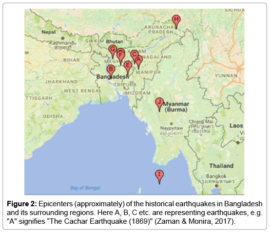
Figure 2: Epicenters (approximately) of the historical earthquakes in Bangladesh and its surrounding regions. Here A, B, C etc. are representing earthquakes, e.g. "A" signifies “The Cachar Earthquake (1869)" (Zaman & Monira, 2017).
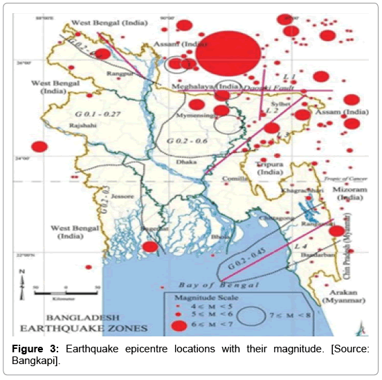
Figure 3: Earthquake epicentre locations with their magnitude. [Source: Bangkapi].
Methodology
There are 38 governments and 84 UGC approved private funded universities in Bangladesh. There is not that much information about the total number of students, but the number will surely cross the five million marks currently. It was difficult to go individually all of the universities to investigate the condition of the awareness of the earthquake. So, at first, a set of questions were made to investigate the situation. We have made an online form on Google where we have put the questions with specific options. We have used social media (like Facebook) to find out the students from different universities and disciplines. We have collected responses from approximately 400 (396) students from 40 different universities and medical colleges. For the better understanding to the students, we have used Bengali in the question set and after the survey; we have converted that to English.
To increase the accuracy of the result we have personally provided the same set of questions and requested to fill (printed copies) to the students of University of Chittagong, one of the biggest universities in Bangladesh where students come to study from the different parts of the country. Here we have collected approximately 400 responses (411) from the students which are approximately 2% of the total number of the students. After that, we have analyzed the data and compared to see the actual situation .Tables 2 and 3 show the overview of the survey. As we tried to understand the awareness level among general students we ensured that no students are from the subjects or departments that run courses on earthquakes, seismology or any other geological phenomenon (like Geography, Soil Science). This survey was running from the early January to mid-February in 2018.
| Total questions asked | 10 |
|---|---|
| Sample size | 807 |
| Age range | 19-27 |
| Qualification of the people under survey | Undergraduate Students, Graduates, \ and Graduate students. |
| No of students under survey (From other Universities) | 396 |
| No. of students under study (From University of Chittagong (CU)) | 411 |
| Total No. of Universities (Except- CU) from where samples are taken | 40 |
| No. of Technical Universities under study | 5 |
| No. of Agricultural Universities under study | 2 |
| No. of Science and Technology Universities under study | 4 |
| No. of Medical colleges under study | 4 |
| No. of General Universities (Non-Technical) | 25 |
Table 3: Overview of the survey.
The form and the responses can be accessed from here:
Link 1 (form): https://goo.gl/Sm5MuK
Link 2 (Online Data): https://goo.gl/fHKSio
Results
From Figures 4 to 13, the responses from the students of different universities and from the University of Chittagong have been represented. In most cases, the responses from the University of Chittagong were quite similar to the online responses provided by the students from different university across the country.
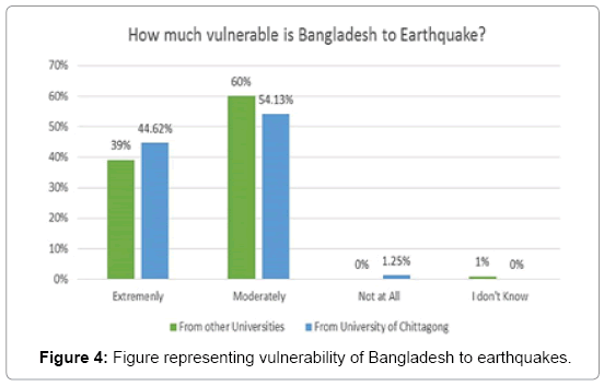
Figure 4: Figure representing vulnerability of Bangladesh to earthquakes.
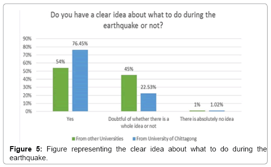
Figure 5: Figure representing the clear idea about what to do during the earthquake.
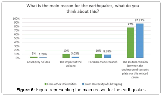
Figure 6: Figure representing the main reason for the earthquakes.
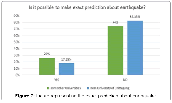
Figure 7: Figure representing the exact prediction about earthquake.
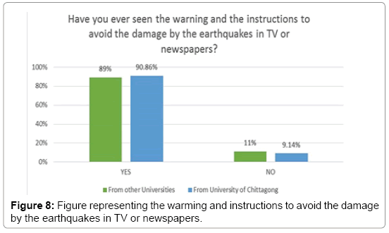
Figure 8: Figure representing the warming and instructions to avoid the damage by the earthquakes in TV or newspapers.
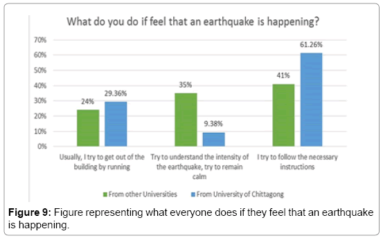
Figure 9: Figure representing what everyone does if they feel that an earthquake is happening.
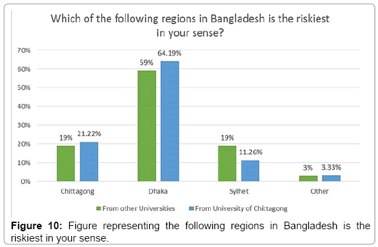
Figure 10: Figure representing the following regions in Bangladesh is the riskiest in your sense.
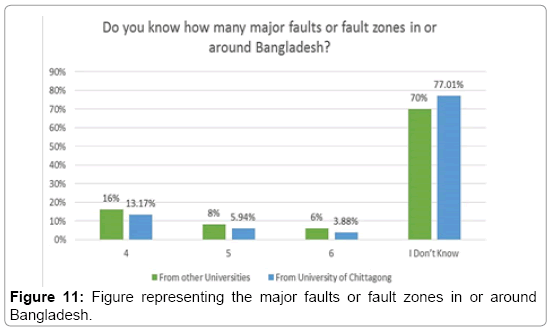
Figure 11: Figure representing the major faults or fault zones in or around Bangladesh.
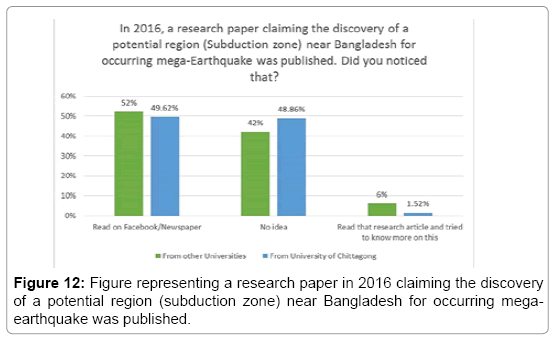
Figure 12: Figure representing a research paper in 2016 claiming the discovery of a potential region (subduction zone) near Bangladesh for occurring megaearthquake was published.
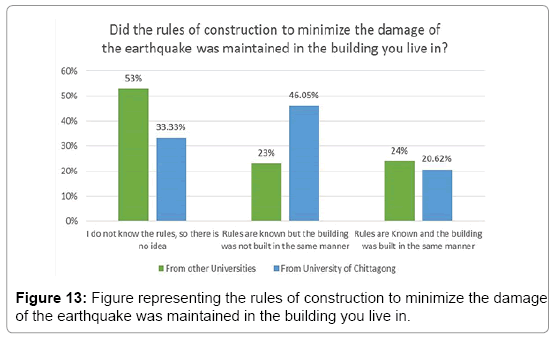
Figure 13: Figure representing the rules of construction to minimize the damage of the earthquake was maintained in the building you live in.
From Figure 4 as expected, with a little amount of exception we can see that most of the students understand or know that Bangladesh is under the threat of earthquakes. Most of them think that we are in a moderate risk zone and the rest think that we are in a dangerous territory. Both of the options are actually got some proofs and the idea behisssnd for asking that particular question was just to clarify the assumption that the university students do know that we are under the threat of earthquakes and the assumption was right. From Figure 5, we can see that most of the students know what should be done during an earthquake but still a large amount of them said they are doubtful about the actions or operations at that time.
Figures 6 and 7 clearly indicates that most of the students know why the earthquakes occur (in most cases) and they cannot be predicted usually. The responses are good but still there are some people have misconceptions about these two things and some people are quite ignorant about this.
As we have mentioned earlier in the past Bangladeshi government had taken some steps to raise the awareness among mass people. Government had employed many technics to reach the instructions about the earthquake in several ways. Figure 8 indicates that majority of the students has seen the instructions to avoid or minimize the damage of the earthquakes. In Figure 9, we see the huge difference between the sources of responses. Here we can see that about one-third of the students from the University of Chittagong said that they prefer running during an earthquake where most of the students from other universities preferred to try to be calm in a greater percentage (Figures 8 and 9).
According to many research Sylhet is the riskiest zone in Bangladesh. Fault zoning, frequent visit of earthquakes also accepts this idea. But if a devastating earthquake occurs near Dhaka as the recent study suggests mentioned earlier, due to its population density and geological position, it will be harmed most by the earthquake. In 2003 a UN report ranked Dhaka as the most vulnerable city at risk of earthquake damage. In 2001 study of 20 cities of the world, Dhaka was ranked topmost in earthquake disaster risk due to its poor building infrastructure lacking earthquake-resistant features, high population density, and poor emergency response and recovery capability So there are no surprises that majority of the students have chosen ‘Dhaka’ as the riskiest territory (Figure 10).
From Figure 11, we can see that majority of the students do not know the number of fault zones in and around Bangladesh. The number of students who knew the exact number was below 7 percent on an average. Comparatively recent research on the earthquake risk in Bangladesh mentioned earlier (Figure 11). The subduction zone poses a great threat for Bangladesh for occurring a mega quake, but almost half of the students are ignorant about this threat where about fifty percent students marked that they have heard this matter through the social media and newspaper but the number of students who went for the research paper or tried to know more about this is very low (Figure 12).
Considering Figure 12 But there are lots to worry about the government as well as the people of the country. Here we can see that a large number of students respond that they are quite ignorant about the rules of constructions to minimize the damage i.e., the building codes.
Bangladesh building codes was first introduced in 1993 and revised in 2006. The purpose of the Code is to establish minimum standards for design, construction, quality of materials, use and occupancy, location and maintenance of buildings within Bangladesh in order to safeguard, within achievable limits, life, limb, health, property and public welfare. BNBC advices people to build simpler buildings. But these days we have seen many complex structured buildings which may not be that much safer during earthquakes. The main reason behind the ignorance about the building codes because of the complexity it possesses. Only the engineers can relatively easily understand the regulations stated there but for a student or a common man it will be very difficult to understand. Even there is not much articles in the native language Bengali about the building codes.
Based on the results obtained we have some specific suggestions for the strategy makers or to the government to improve these conditions. They must not forget that the people under survey are the people who are taking the higher education and many of them will serve as teachers in various disciplines. If they get the proper information there is higher chances of spreading the knowledge among the future generations. Besides many of them will also spread the knowledge who are quite ignorant about the devastating effect of the earthquakes (Figure 13).
• Through this survey, we have seen that most of the students have seen the instructions about safety from the government initiative, but many have reported they are not sure that they know the rules exactly and still knowing the rules many of them prefer running during an earthquake. So, the government should continuously run various campaigns to give proper ideas to all.
• For the last few years, there has been a tremendous rise in usage of social media websites, so launching many campaign or initiative to increase the awareness the government can go for both the conventional ways as well as on the web especially in social media.
• In our survey we have observed the lack of knowledge about the fault zones and the newer research outcomes about the earthquakes. More information can be added in the school books so that the awareness level can increase about the fault zones and how much threat they can possess. Government can inspire to learn the recent studies on earthquake in Bangladesh by offering several workshops in different universities where people who are working in this field will share their ideas and researches.
• There have been many efforts to generalize the building codes (BNBC), but still it seems very difficult to the people who are not from some particular fields. So, the government should find a way to make this easier to the common people. At least the rules that are essentials must be spread among the mass people [13-17].
Discussion and Conclusion
From the results, we can see that the general ideas and threats about earthquake persist among the students of universities in Bangladesh. But when coming to the matter of building codes or the safety rules for construction of buildings we see a horrible situation. The government must take necessary steps to improve this situation and also investigate the reasons why the mass people are not happy with the degree of efforts they are applying. They should accelerate their work and try to spread more awareness among the mass people. We see a lack of knowledge about the fault zones and the recent studies about earthquake among the students which should also be improved.
However, we have mentioned that the number of university students is huge. We have asked only 800 among them with a process where we are not sure that the result will deviate or not if we go for taking responses from the greater number of students. As we have utilized online responses, we are not sure that all the persons who responded didn’t take any help from others. But we have told them not to do so. Also, we have observed that most of the student responded from different universities were from science background who are expected to have better knowledge of the earthquake than the students from the non-science background. This might have created some sort of inaccuracy in the results. We have taken responses from different disciplines or subjects in the University of Chittagong, but the results were quite similar which signifies that the margin of error is too small for this reason. This also signifies the accuracy of our question set to evaluate the awareness level among the students.
References
- Ziauddin N (2016) A study on earthquake preparedness in schools in Dhaka North City Corporation (Doctoral dissertation, BRAC University, Dhaka, Bangladesh.
- Al-Zaman MDA, Monira NJ (2017) A study of earthquakes in bangladesh and the data analysis of the earthquakes that were generated in bangladesh and its’ very close regions for the last forty. J Geol Geophys, 6: 300.
- Alam M, Ansery MA, Chowdhuary RK, Uddin AJ, Islam S, et al. (2008) Evalution of building's vulnerability to earthquake in old part of sylhet and construction safety rules. Int Journal of Engineering 19: 33-34.
- Kumar P, Yuan X, Kumar MR, Kind R, Li X, et al. (2007) The rapid drift of the Indian tectonic plate. Nature 449: 894.
- Ali MH (1998) Earthquake database and seismic zoning of Bangladesh. INCEDE Report 11: 59-73.
- Morino M, Kamal AM, Muslim D, Ali RME, Kamal MA, et al. (2011) Seismic event of the Dauki Fault in 16th century confirmed by trench investigation at Gabrakhari Village. Journal of Asian Earth Sciences 42: 492-498.
- Steckler MS, Mondal DR, Akhter SH, Seeber L, Feng L, et al. (2016) Locked and loading megathrust linked to active subduction beneath the Indo-Burman Ranges. Nature Geoscience 9: 615.
- Roy S (2014) Probabilistic prediction for earthquake in Bangladesh: Just how big does the earthquake have to be next years? Open Journal of Earthquake Research 3: 108.
- Chakravorti BK, Kundar M, Moloy DJ, Islam J, Faruque SB (2015) Earthquake Forecasting in Bangladesh And Its Surrounding Regions. European Scientific Journal 11: 18.
- Khan AA, Hoque M, Akhter SH, Hoque MA (2001) Earthquake in Bangladesh: A natural disaster and public awareness. The Journal of NOAMI 18: 37-46.
- Islam R, Islam MN, Islam MN (2006) Earthquake risks in Bangladesh: Causes, vulnerability, preparedness and strategies for mitigation. ARPN Journal of Earth Sciences 5: 75-80.
- Ahmed MNQ (2007) Public awareness on earthquake: A study on a residential area under Sylhet City of Bangladesh. Young 18: 36.
- Bilham R (2004) Earthquakes in India and the Himalaya: tectonics, geodesy and history. Annals of Geophysics 47: 2-3.
- Saha MK (2010) Earthquake: Emerging threat for Dhaka city. Nature Geoscience 6: 15.
- Alam E (2017) A historical and geographical analysis of earthquake and associated tsunami events on Bangladesh Coast. Journal of Geography 12: 54-60
- Lamont-Doherty Earth Observatory (2016) Giant quake may lurk under Bangladesh and beyond.
Citation: Md. Zaman AA, Sifty S, Rakhine NJ, Md. Abdul A, Amin R, et al. (2018) Earthquake Risks in Bangladesh and Evaluation of Awareness among the University Students. J Earth Sci Clim Change 9: 482. DOI: 10.4172/2157-7617.1000482
Copyright: © 2018 Md. Zaman AA, et al. This is an open-access article distributed under the terms of the Creative Commons Attribution License, which permits unrestricted use, distribution, and reproduction in any medium, provided the original author and source are credited.
Select your language of interest to view the total content in your interested language
Share This Article
Recommended Journals
Open Access Journals
Article Tools
Article Usage
- Total views: 14019
- [From(publication date): 0-2018 - Nov 21, 2025]
- Breakdown by view type
- HTML page views: 12875
- PDF downloads: 1144