Evidence of Northward Limit of Sea Level Transgression in and around Central Part of Bangladesh during Holocene
Received: 11-Aug-2014 / Accepted Date: 30-Oct-2014 / Published Date: 10-Nov-2014 DOI: 10.4172/2157-7617.1000233
Abstract
The study deals with reconstruction of paleoenvironment of the central part of Dhaka in order to explore the northward limit of sea level transgression in Bangladesh. The study area is located at Sutrapur village on the left bank of Turag River in the Pleistocene Madhupur tract of Dhaka city. Lithostratigraphic analysis along with pollen and diatom analyses were performed. The lithostatigraphic records at Shutrapur site show that the Holocene fresh water deposit overlies the Madhupur Clay and Sand Formation. The site shows evidence of weathering in Madhupur Clay and Sand Formation which infers that the tract might have eroded and exposed for some period and weathering acted upon the tract during that time. The pollen and diatom results reveal that the dissect valley filled with Holocene fresh water lentic deposits during the late Holocene period. In addition, the present study found that the Shutrapur site could not receive marine water while the Chatbari site (23 km south from Shutrapur site) experienced with marine transgression approximately 5500 cal yrs BP. It infers that the marine limit persisted at or around the Chatbari site and marine influence could not reach at Shutrapur site.
Keywords: Madhupur tract; Facies analysis; Sea level change; Pollen, Diatom; Lentic environment
8419Introduction
Most of Bangladesh had low elevation throughout its geologic history that made it very sensitive to the Relative Sea Level (RSL) changes which influenced geologic processes of weathering, erosion and deposition of sediments. The shoreline of Bay of Bengal has been observed not to be static in relation to previous geological events [1-5]. During the peak of the last glaciation (18000 yrs BP), the Bengal Lowland experienced dry climatic conditions and sea-level was 100 m or much lower than the present sea level [1]. At about 12000 yrs BP, south-west monsoon became prominent which caused heavy rainfall and sea-level started rising very rapidly [6]. This amplified monsoon water plus deglaciated melted water from the Himalayas flowed over the Bengal Lowland, thus the initial Madhupur and Barind surfaces were highly dissected and created some local pools and depressions [6].
The Indian Summer Monsoon (ISM) during early to middle Holocene was generally stronger than today, with peaks identified at 8500, 6400, and 2700 yrs BP detected in numerous ISM records [7-9]. Umitsu [2], Kudrass et al. [3] and Goodbred and Kuehl [4] stated that during the mid-Holocene sea level the bay was slightly higher, the climate was warmer, and rivers of this region discharged up to two and half times more than in present times. Evidence from Japan, the Sunda Shelf, South Africa, Sri Lanka and the east-coast of India suggest that the middle Holocene transgression rose (high stand) above the present MSL in many parts of the Indo-pacific region [10-20]. Fixed biological indicators (oyster beds) have been used at one site on the South China Sea coast to infer the amplitude and timing of the mid-Holocene high stand which was no greater than 2 m above modern sea level at 5140 yrs BP. Banerjee [20] studied regional RSL change on the east Indian coastline, utilizing beach ridges and exposed Porites colonies to indicate two mid-late Holocene high stands; the first peaking at 7300 yrs BP was 5-3 m above the present MSL, followed by a RSL fall, and a second pulse of minor RSL rise culminating between 4300 and 2500 yrs BP which was 3 m higher than the modern MSL.
Rashid et al. [21] showed five phases of sea level changes, on the basis of paleo-environmental records of five sites such as Sony, Vatpara, Dobadia, Chatbari and Nayanipara located in the southern fringe of Madhupur tract, like transgression phase at approximately 7500 yrs BP, regression phase at about 6500 yrs BP, transgression phase at approximately 6000 yrs BP, regression phase between 5500 to 5000 yrs BP and fresh water peat deposition after 5000 yrs BP and onwards. The Chatbari site was experienced with sea-level transgression during 5500 yrs BP and the site is located in the south-western part of Madhupur tract [21,22]. The present study is an attempt to find out the northward limit of sea-level changes and will investigate whether sea-level changes occurred far north of Chatbari site. The lithofacies characteristics along with pollen and diatom evidences have been performed to indicate the past position (space) of relative sea level in the central part of Dhaka city.
Location, topography and general geology of the study area
The study site is located at Shutrapur (24 05.128’N; 90 11.811’E) village in the western part of Madhupur tract (Figure 1). The site Sutrapur was selected from Gazipur district which is located on the left bank of the Turag River and the site is only 23 km north from Chatbari site. The ground elevation around of the site is 9 meters. It appears a floodplain area filled with Holocene sediments (Figure 2). The surface is flat and the floodplain land used to inundate by annual flood.
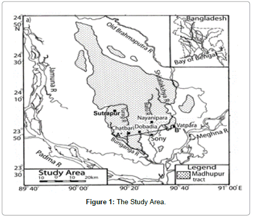
Figure 1: The Study Area.
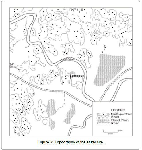
Figure 2: Topography of the study site.
The study area is covered by two lithostratigraphic units, namely, Madhupur Clay Formation [23,24] of the Pleistocene age and Basabo Silty-clay Formation of Holocene (Recent) age [24]. Upper part of Madhupur Formation is represented by highly weathered reddish- brown mottled clay, whereas the lower part is composed of micaceous sand having some ripple marks and cross-bedded primary structures. The Madhupur Clay Formation is the oldest deposits exposed in the study area having erosional surfaces, floodplains, tract valleys and abandoned channels. Low lying swamps and marshes located in and around the city are other major topographic features. The incised channels and depressions in and around the area are floored by Holocene deposits. The floodpain deposits of Holocene age overlie the Madhupur Formation. The Holocene Series in the type locality at Bashabo is called Bashabo Formation [24]. The Bashabo Formation of Holocene age is represented by yellowish brown to bluish-grey sand to clay which is the youngest deposits widely occupied in the floodplain of the central Bangladesh. The study site and Bashabo are in the same locality, within 43 km, and lithology has been found similar. Hence, the deposits exposed at the localities are considered as Bashabo Formation.
Lithostratigraphy and sedimentary structure
On the basis of their sedimentary characteristics, the 15m core was divided into nine lithofacies units (Table 1). The characteristics of these units are described below, in descending order.
| Unit no. | Period | Depth | Color | Lithologic description |
|---|---|---|---|---|
| (meter) | ||||
| Unit 1 | Holocene | 1.5-3.1 | Blackish and ash | Deep grey clay |
| Unit 2 | Holocene | 3.1-4.5 | Deep black to dark black | Massive clay in texture, sometimes mixed by sandy silt |
| Unit 3 | Holocene | 4.5-5.5 | reddish brown to deep black | Sandy mud and clay in sedimentary structure |
| Unit 4 | Holocene | 5.5-6.7 | dark black | Light grey colored clay and decomposed organic matter |
| Unit 5 | Holocene | 6.7-9.1 | reddish black to grayish black | Clay and silt |
| Unit 6 | Holocene | 9.1-9.8 | Gray | Silt clay |
| Unit 7 | Holocene | 9.8-10.7 | light bluish-grey to dark bluish-grey mud | Fine silt and organic matter is rich |
| Unit 8 | Holocene | 10.7-3.7 | bluish-grey to radish grey mud section | Silt to clay |
| Unit 9 | Pleistocene | 13.7-5.2 | Red | Sand and silt |
Table 1: Stratigraphic description at Sutrapur.
Methodology
Fifteen meter borehole sample was collected vertically by wash pipe to examine the lithostratigraphy of the section. Samples for pollen and diatom analyses were taken for two units such as from Unit-4 (5.5 m to 6.7 m) and Unit-7 (9.8 m to 10.7 m) to represent the major lithologic variations.
During sampling, special care was taken to avoid contamination or mixing. To extract the palynofossils for samples of 2 sites, 10 gm samples were treated for each samples with hydrochloric acid (HCl) and kept 1 hour to dissolve calcareous materials. Thereafter, added nitric acid and kept the residue for 2 days to dissolve organic matter and carbonates, if any. Then it was sieved to separate the large particles. Finally, added sodium hydroxide to clean the dark coating from the pollen body. Single-mount specimens are made for further studies. The pollen assemblages of other 4 sites were done by the Dept. of Geology, University of Dhaka, Bangladesh. The remainder of the original samples and treated and single-mount specimens are preserved in the laboratory of Geology dept. in Dhaka University, Bangladesh.
For diatom analysis, first samples were added with 75 ml 30% hydrogen peroxide in 1000 ml beaker and kept for 24 hours. Then added pinch of potassium dichromate and kept for 2 hours and boiled. Finally, added distilled water settled and decanted. Single-mount specimens are made for further studies.
Result and Discussion
Pollen and diatom analysis
Unit-4 (5.5 m to 6.7 m) is characterized by mangrove palm pollens such as Phoenix sylvestris. In addition, it shows some fungal spores (Figures 3a and 3b). The environment appears to be a coastal belt and shows evidence in favour of marine influence around the succession site. Unit- 4 and Unit-7 show one diatom named Pinnularie gentiles (Figure 4). The diatom is a fresh water diatom which can be observed in lentic environment like, ponds, swamps or lake.
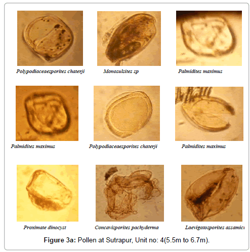
Figure 3a: Pollen at Sutrapur, Unit no: 4 (5.5m to 6.7m).
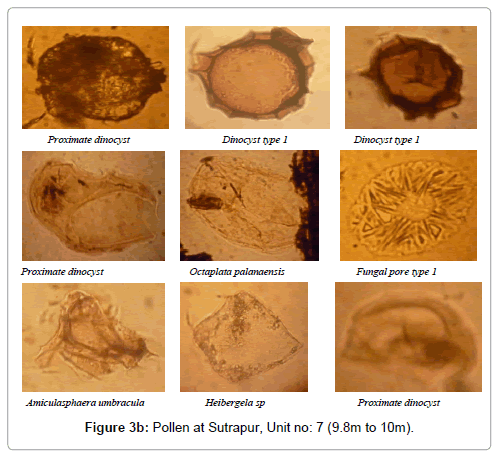
Figure 3b: Pollen at Sutrapur, Unit no: 7 (9.8m to 10m).
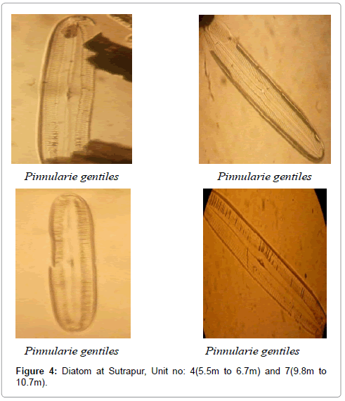
Figure 4: Diatom at Sutrapur, Unit no: 4(5.5m to 6.7m) and 7(9.8m to 10.7m).
Fifteen kinds of pollen and one kind of diatom were found in the study area and maximum pollens were palm pollen.
Of the nine sedimentary units identified, the clay with organic matter (unit 1 to 8) indicates that the deposits of the site are of Holocene epoch which is associated with low energy depositional environment such as lakes and marine. The unit-9 of this site appears weathered soil infers that the Holocene sediments overlies the Madhupur Clay and Sand Formation of Pleistocene age which might have eroded and exposed for some period and weathering acted upon it. The site Dobadia, 30 km south-east of Sutrapur site, supports such erosion activity of the tract during the regression occurred at approximately 6500 yrs BP [21].
Many evidences support that the Madhupur Formation was highly sensitive to RSL changes and affected by erosion activities throughout the Late Pleistocene to Holocene epoch [6,22] and the erosional valleys of Madhupur surfaces in and around Dhaka city had been inundated with brackish and fresh water (Rashid, 2009). The Madhupur basement has been found to be exposed at Sony in Narayangonj, Baghabon in Pubail, and Dobadia in Dhaka [22]. Freshwater sediments are also found at Sony, Nayanipara, and Dobadia and the sites are located in the Madhupur Tract [22]. All evidences supports that the erosion activities occurred throughout the Holocene which were subsequently filled with Holocene marine water and freshwater deposits during middle to late Holocene epoch [21].
The diatom is providing evidence of lacustrine or lentic environment. Lantic environment occurs in pools, along the sides of the river channel away from the main force of the flow, in and among rooted aquatics, and sometimes behind obstructions such as logs that inhibit the flow of river. The palm pollen infers that coastal environment prevailed around the site and the reworked palm pollen in sediments formed from the nearby coastal environment. During 5500 yrs cal BP the Chatbari site experienced with sea level transgression which showed abundant marine diatom and few palm pollens [21]. The Chatbari site is only 23 km south from Sutrapur site and Chatbari is located near the Turag River valley. It inferred that during middle Holocene the nearby river had marine influence and the environment thought to be estuarine [22]. The palm pollens found in Sutrapur site might have transported by air or water from or around Chatbari site. The pollen may have been transported by the river which had tidal affect during middle Holocene period. The thin-bedded (about 4 cm) organic matter deposits (Fig and Fig) thought to be vegetation coverage in the site. The litho-biofacies evidences of the study support that the site had fresh water environment like pool, swamp or lake. Hence, the site was not experienced with marine transgression.
It can be inferred from the study that the Sutrapur area of Madhupur tract was dissected and formed a valley during the regressive phase observed in Sony (4080-4030 and 1820-1530 cal BP), Chatbari (4870-4780, 3080-2760 cal BP) and Nayanipara (3690-3440 cal BP) occurred in late Holocene epoch [21]. The faunal analysis including pollen and diatom results provide evidence that the dissected valley filled with Holocene fresh water lentic deposits during the late Holocene period. In addition, the present study supports that the Shutrapur site, located in the dissected valley of the western part of Madhupur tract, could not receive marine water while the Chatbari site showed marine environment during 5500 cal yrs BP [21].
Conclusion
The study is an attempt to find out the northward limit of sea level transgressions in Bangladesh and the results infer that the marine limit persisted upto the Chatbari site, located in the south-western part of the tract, and marine influence could not reach at Shutrapur. This is a unique finding of sea level change towards north of Dhaka during Holocene which would be a new addition in Holocene sea level scenarios in Bangladesh.
References
- Umitsu M (1987) Late Quaternary sedimentary environment and landform evolution in the Bengal Lowland. Geogr Rev Japan 60: 164-178.
- Umitsu M (1993) Late Quaternary sedimentary environments and landforms in the Ganges Delta. Sediment Geol 83: 177-186.
- Kudrass HR, Spiess V, Michels M, Kottke B, Khan SR (1999) Transport processes, accumulation rates and a sediment budget for the submarine delta of the Ganges-Brahmaputra, and the Swatch of No Ground, Bangladesh. In International Seminar of the Quaternary Development and Coastal Hydrodynamics of the Ganges Delta in Bangladesh, Dhaka, 20-21 September, Geological Society of Bangladesh.
- Goodbred SL, Kuehl SA (2000) The significance of large sediment supply, active tectonism, and eustasy on margin sequence development: Late Quaternary stratigraphy and evolution of the Ganges-Brahmaputra delta. Sediment Geol 133: 227-248.
- Islam MK (2001) Evidences of neotectonics in and around Lalmai Hills, Bangladesh. Bangladesh J Geol 20: 55-66.
- Monsur MH (1995) An Introduction to the Quaternary Geology of Bangladesh. City press and publications, Dhaka, Bangladesh.
- Fleitmann D, Burns SJ, Mudelsee M, Neff U, Kramers J, et al. (2003) Holocene forcing of the Indian monsoon recorded in a stalagmite from Southern Oman. Sci 300: 1737-1739.
- Gasse F, Arnold M, Fontes JC, Fort M, Gibert E, et al. (1991) A 13,000-year climate record from western Tibet. Nature 353: 742-745.
- Van Campo E, Cour P, Sixuan H (1996) Holocene environmental changes in BangongCobasin (western Tibet), part 2: The pollen record. Palaeogeogr Palaeocl Palaeoecol 120: 49-63.
- Wang YJ, Cheng H, Edwards RL, He YQ, Kong XG, et al. (2005) The Holocene Asian Monsoon: Links to solar changes and North Altantic climate. Sci 308: 854-857.
- Ota Y, Matsushima Y, Moriwaki H (1982) Note on the Holocene sea-level study in Japan- On the basis of “Atlas of Holocene Sea-level Records in Japanâ€. The Quatern Res 21: 133-143.
- Ota Y, Umitsu M, Matsushima Y (1990) Recent Japanese research on relative sea level changes in the Holocene and related problems-Review of studies between 1980 and 1988. The Quatern Res 29: 31-48.
- Nakada M, Yonekura N, Lambeck K (1991) Late Pleistocene and Holocene sea-level changes in Japan: implications for tectonic histories and mantle rheology.Palaeogeogr Palaeocl Palaeoecol 85: 107-122.
- Geyh MA, Kudrass HR, Streif H (1979) Sea level changes during the Late Pleistocene and Holocene in the Strait of Malacca. Nature278: 441-443.
- Tjia HD, Fuji S, Kigoshi K (1983) Holocene shorelines of Tioman Island in the South China Sea. Geologie en Mjinbouw 62: 599-604.
- Hesp PA, Hung CC, Hilton M, Ming CL, Turner IM (1998) A first tentative Holocene sea-level curve for Singapore. J Coast Res 14: 308-314.
- Hanebuth TJJ, Stattegger K, Grootes PM (2000) Rapid flooding of the Sunda Shelf: A late-glacial sea-level record. Sci 288: 1033-1035.
- Compton JS (2001) Holocene sea-level fluctuations inferred from the evolution of depositional environments of the southern Langebaan Lagoon salt marsh, South Africa. Holocene 11: 395-405.
- Katupotha J, Fujiwara K (1988) Holocene sea level change on the Southwest and South Coast of Sri Lanka. Palaeogeogr Palaeocl Palaeoecol 68: 189-203.
- Banjeree PK (2000) Holocene and Late Pleistocene relative sea level fluctuations along the east coast of India. Mar Geol 167: 243-260.
- Rashid T, Suzuki S, Sato H, Monsur MH, Saha SK (2013) Relative Sea level changes during the Holocene in Bangladesh. J Asian Earth Sci 64: 136-178.
- Rashid T (2009) Reconstruction of Holocene Paleoenvironment and Relative Sea level changes in Bangladesh. An unpublished thesis, Japan.
- Morgan JP, McIntire WG (1959) Quaternary geology of the Bengal Basin, East Pakistan and India. B GeolSoc Am 70: 319-342.
- Monsur MH, Paepe R (1994) Holocene stratigraphy and palaeoclimatological interpretation of the deposits of the Madhupur, Barind and Chalanbil areas of the Bengal Basin, Bangladesh. Bangladesh J Sci Res 12: 255-264.
Citation: Rashid T, Saha SK, Hassan Z (2014) Evidence of Northward Limit of Sea Level Transgression in and around Central Part of Bangladesh during Holocene. J Earth Sci Clim Change 5: 233. DOI: 10.4172/2157-7617.1000233
Copyright: ©2014 Rashid T, et al. This is an open-access article distributed under the terms of the Creative Commons Attribution License, which permits unrestricted use, distribution, and reproduction in any medium, provided the original author and source are credited.
Select your language of interest to view the total content in your interested language
Share This Article
Recommended Journals
Open Access Journals
Article Tools
Article Usage
- Total views: 16168
- [From(publication date): 11-2014 - Aug 23, 2025]
- Breakdown by view type
- HTML page views: 11447
- PDF downloads: 4721