Human Vulnerability Index: Adaptation & Mitigation to Climate Change among Fisher-Folk in India of Bay of Bengal Region
Received: 03-May-2023 / Manuscript No. EPCC-23-95204 / Editor assigned: 05-May-2023 / PreQC No. EPCC-23-95204 (PQ) / Reviewed: 19-May-2023 / QC No. EPCC-23-95204 / Revised: 22-May-2023 / Manuscript No. EPCC-23-95204 (R) / Published Date: 29-May-2023 DOI: 10.4172/2573-458X.1000341
Abstract
Evidence of climate-change impacts is strongest and most comprehensive for natural systems. Impacts on human systems have also been attributed to climate change, with a major or minor contribution of climate change distinguishable from other influences. The objective of the present study is to identify the intensity of the human vulnerability to climate change in a multi-dimensional context. The study area is located along the coast line 20-30 m above sea level on the southeast coast of Indian Peninsula bordered by Bay of Bengal and severely prone to cyclonic occurrences namely Hudhud, Phailin and Vardah. A track of cyclonic disturbances, cyclones and severe cyclones over Bay of Bengal (BOB) were observed from 1994 to 2015. The study was commissioned as a part of the national project, National Innovations on Climate Resilient Agriculture (NICRA), Indian Council of Agricultural Research (ICAR) during the year 2017.The impact of climate change on the livelihood of fishing community was measured through integrated Human Vulnerability Index (HVI) approach. The Domain specific HVI was found to be high for livelihood followed by climate variability, economic, socio demographic, and health dimensions.
Keywords
Climate change; Fisher-folk; Bay of Bengal; Human vulnerability index; Hushed cyclone; Adaptation and mitigation
Introduction
Climate change involves complex interactions and changing likelihoods of diverse impacts [1]. Climate change may alter the frequency and intensity of extreme events like floods, droughts, heat waves and hurricanes but difficult to attribute to anthropogenic climate changes [2]. The environmental fluctuations and extreme climate change events exert aggravated effects on global food production and the growth rate begins to decrease in some regions, influencing the stability of the future global food supply and demand [3, 1]. Extreme weather events such as cyclones and floods may further intensify these impacts by disrupting fishing operations and land-based infrastructure [4]. The land-based assets can also be deteriorated by sea-level rise, land erosion, and variations in temperature and rainfall. These impacts may result in vulnerability of fishery-dependent livelihoods [4, 5].
Vulnerability is a function of the character, magnitude, and rate of climate change, which encompasses a variety of concepts and elements including sensitivity or susceptibility to harm and lack of capacity to cope and adapt [5]. In addition to synthesize the climate science, there is also a need to analyze the multi-dimensional climatic projections in the context of human eco-systems, livelihood patterns, socio-demographic profiles and underlying health factors in order to realize the complex network of issues due to the impact of climate change [6]. Quantitative projections of climate change by combining models of varying complexity and observations and expressed in terms of probabilities can measure current uncertainties [6, 7]. These projections illustrate the robust concept of vulnerability and the capacity of individuals and social groups to respond, to cope with, recover, adapt to external disastrous events placed on their livelihoods and well-being [8, 9].
The implications of vulnerability are an interactive phenomenon involving various social and environmental factors to climate change and the ability to adapt to future challenges [10-12]. Generally, poorer and less empowered countries and individuals are more vulnerable to climate impacts, and the vulnerability of fisheries is likely to be higher where they already suffer from overexploitation or overcapacity [13]. Vulnerability is approached as a complex, constantly evolving and changing phenomenon that needs to be situated within interactions between biophysical, socio-economic and livelihood elements [14, 15, and 16].
Ecosystem-based coastal adaptation approaches are still emerging which require an improved understanding of key ecosystem services of coastal communities in order to assess risk, aid coastal development planning and build decision support systems [16,17]. The present paper throws insight to delineate the issues and challenges in the context of vulnerability of climate change. The objective of the present study is to assess the multi- dimensional vulnerability index of fishing communities and to identify adaptation and mitigation measures in relation to climate change and propose strategies & policies to protect the livelihood of fishing communities in the context of climate change.
Materials and Methods
The locale of the study is East Godavari District in the state province of Andhra Pradesh in India. The `coastal belt of Andhra Pradesh extends up to a length of 972 km and is third longest among the states of India. The Coastline of Andhra Pradesh is located on the southeast coast of Indian Peninsula bordered by Bay of Bengal. The coastal corridor consists of several ports, harbors, industries and forms the major platform for exports and marketing. As per Revenue disaster management of Andhra Pradesh, A.P. is exposed to cyclones, storm surges, floods and droughts. A moderate to severe intensity cyclone can be expected to make landfall every two to three years. About 44 percent of the state is vulnerable to tropical storms and related hazards. In India, the cyclones develop in the pre-monsoon (April to May) and post-monsoon seasons (October to December), but most of them tend to form in the month of November [18,19].
The study area is located along the coast line, and situated 22-28 m above sea level ranging from Latitude: 17.04 N-17.26 N and Longitude: 82.27 E to 82.51 E. The area is climate sensitive and affected severely by cyclones viz. Hudhud, Phailin etc. in the district and lies in the coastal belt with a number of hamlets. Hudhud is the very severe cyclonic storm that crossed Visakhapatnam coast during 07-14 October, 2014 after 1985 which affected East Godavari, Visakhapatnam, Vizianagaram & Srikakulam districts of Andhra Pradesh and Ganjam, Gajapati, Koraput & Malkangiri districts of Odisha with a wind speed of 180 kmph and gusting wind speed of 195 kmph affecting about 4484 villages and 20,93,508 families. Cyclonic track of Hudhud and Phailin is illustrated in (Figure 1). A representative sample of 200 families from Konapapa peta, Moolapeta, Chinthakayalapeta, Perumallapuram, Hukhumpeta villages from U. Kothapalli and Thondangi mandals of East Godavari district, A.P, Indiawere selected based on purposive and stratified random sampling. All the respondents from selected villages have their major occupation as fishing. The data was elicited by using different methods from the focus group discussions, open forum feedback sessions and interviews from the key informants within the framework of fishing community [20].

Figure 1: Cyclonic track of Hudhud and Phailin.
Vulnerability is a function of the character, magnitude, and rate of climate change and variation to which a system is exposed, the sensitivity and adaptive capacity of that system [21]. Indicators for assessment of vulnerability include food security, infrastructure sensitivity, ecosystem sensitivity, human health sensitivity, water resource sensitivity and economic capacity, human and civic resources and environmental capacity [ 22, 23]. Interpreted vulnerability in terms of integration of three components exposure, sensitivity and adaptive capacity. Indicators were classified as climate, water and land resources and adaptive capacities were classified as human capital, social capital, financial capital and physical capital. As per the data retrieved from Regional Specialized Meteorological Centre (RSMC), New Delhi, a track of cyclonic disturbances, cyclones and severe cyclones over Bay of Bengal (BOB) were observed from 1994 to 2015. Recently there is an increasing trend in overall cyclones as shown in (Figure 2) with an annual frequency of cyclonic disturbances (maximum wind speed of 17 knots or more), cyclones (34 knots or more) and severe cyclones (48 knots or more) over the Bay of Bengal (BOB). Hence the vulnerability studies of coastal communities attain major importance with respect to increasing trend in cyclones.

Figure 2: Annual cyclones over Bay of Bengal.
Measuring and assessing vulnerability
Vulnerability index describes the indicators and sub-indicators used to compute the vulnerability of fisherwomen to climate change factors. Main goal of the indicators is to map the relative vulnerability of fishing community to various components during Hudhud cyclone. Livelihood, socio-demographic, economic, health and climate variability are the different indicators used to assess vulnerability index of fishing communities. The indicator scores are determined by summing the scores of sub-indicators by the number of sub-indicators. The vulnerability index was developed by using the procedure developed by IPCC, by including several factors in the frame work.
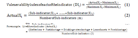
Xi = Sub-Indicator
m=Number of Sub-Indicators
Actual Xi= Average of percentage of population effected by the subindicators
Minimum Xi =percentage of population effected by all the subindicators
Maximum Xi = percentage of population effected by at least one
sub-indicators
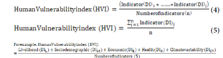
The HVI is calculated by summing the indicator scores using the following equation:
Each indicator was sub divided into three to five sub-indicators and vulnerability dimensional index of fishing communities was computed and categorized as least vulnerable (<0.25), moderately vulnerable (0.25-0.5) and highly vulnerable (>0.5) as shown in (Table 1).
| Indicators | Sub-Indicators | Families Affected (%) | Conceptual explanation | Dimensional index (DI) | Degree of vulnerability | Human Vulnerability Index (HVI) |
|---|---|---|---|---|---|---|
| Livelihood | Shelter loss | 96 | Crisis in primary needs in coastal area viz. food, shelter, water & fuel classified under livelihood indicator as reported by at least one family member | 0.60* | highly vulnerable | 0.51803* |
| Shortage of fuel | 83 | (highly vulnerable) | ||||
| Shortage of drinking water | 96 | |||||
| Loss of assets, inputs and production capacity | 87 | |||||
| Shortage of food (98%) | 98 | |||||
| Socio demographic | Loss of facilities, public utilities | 82 | Calculated based on the respondents’ statement to the disaster in a social perspective | 0.49 | moderately vulnerable | |
| Education (school dropout rate) | 10 | |||||
| Early marriages | 4 | |||||
| Loss of fishing infrastructure | 74 | |||||
| Economic | Interruption of market access and unemployment | 97 | Loss of economic sources which in turn effect the purchase power of the families due to disaster | 0.52* | highly vulnerable | |
| Reduced income & increased debts | 85 | |||||
| Depletion of savings | 89 | |||||
| Loss of occupation & reduced fish catch | 94 | |||||
| Health | Spread of epidemics | 58 | Percentage of households that report at least one family member with chronic illness, prolonged stress and lack of health facilities | 0.42 | moderately vulnerable | |
| Ill-health due to contaminated aquatic species & Zoonotic diseases | 24 | |||||
| Nutritional deficiencies & post-traumatic stress | 86 | |||||
| Lack of health facilities | 32 | |||||
| Climate variability | Solidarity issues and conflicts | 52 | Percentage of households that reported having death, injury, conflicts and eco-system damage and contamination | 0.56* | highly vulnerable | |
| Injury or death of family member | 5.5 | |||||
| Damage to the eco system | 75 |
(Note: > 0.5: highly vulnerable*; 0.25-0.5: moderately vulnerable; < 0.25: least vulnerable.)
Livelihood indicator (DIL) includes five sub-indicators viz., 1.Loss of shelter 2.Shortage of fuel 3.Shortage of drinking water 4.Loss of assets, inputs and production of capacity 5.Shortage of food. The number of family members affected and the percentage of families affected by the cyclone with regard to primary needs was calculated as reported by at least one family member in the family. The livelihood dimensional index (DIL) was calculated by using equation 1.Socio demographic indicator (DISD) includes four sub indicators viz., 1. Loss of public facilities, public utilities 2. Terminating education (school dropouts) 3. Teen age/ early marriage 4. Loss of infrastructure. The number of family members affected and the percentage of families affected by the cyclone was calculated based on the respondents’ statements to the disaster in a social perspective as reported by at least one family member in the family. The socio demographic dimensional index (DISD) was calculated by using equation 1.
Economic indicator (DIE) includes four sub-indicators 1.Interruption of market access and unemployment 2. Reduced income and increased debts 3. Depletion of savings. 4. Loss of occupation and reduced fish catch. The number of family members affected and the percentage of families affected by the cyclone with regard to economic indicator was calculated based on loss of economic sources which in turn affect the purchase power of families. The economic indicator dimensional index (DIL) was calculated by using equation 1. Health indicator (DIH) includes four sub indicators 1. Spread of epidemics 2. Ill-health due contaminated aquatic species and zoonotic diseases 3. Nutritional deficiencies and post-traumatic stress 4. Lack of health facilities.
Percentage of households that report at least one family member with chronic illness, prolonged stress was calculated based on the respondents statements to the disaster in a health perspective. The health indicator dimensional index (DIH) was calculated by using equation 1.
Climate variability index (DICV) includes three sub- indicators 1.Solidarity issues and conflicts 2.Injury or death of family member 3.Damage to the ecosystem. Percentage of households that reported having death, injury conflicts regarding fishing borders, eco-system damage and contamination was calculated based on the respondent’s statements to the disaster in a climate change perspective. The climate variability dimensional index (DICV) was calculated by using equation 1. The human vulnerability index (HVI) was calculated by taking the average of five dimensional indicators as using equation 3.
Results and Discussion
Results of the paper were discussed and presented under the following indicators a) livelihood vulnerability index b) sociodemographic vulnerability index c) economic vulnerability index d) health vulnerability index and e) climate variability vulnerability index. Each indicator was sub divided into three to five sub-indicators and vulnerability dimensional index of fishing communities was computed and categorized as least vulnerable (<0.25), moderately vulnerable (0.25-0.5) and highly vulnerable (>0.5). Frihy and Sayed [24] classified vulnerability variables/sub-indicators on the similar grounds depending on the geographical application of the coastal vulnerability index. As the climate change is causing uncertainties and as a result, there is depletion in fish catch affecting their livelihood and making them vulnerable to the cyclones as the fisher men are forced to invade deeper into the sea by risking their lives.
Vulnerability Index
The domain specific vulnerability indicators were chalked out and depicted in (Table 1). Human vulnerability index was calculated in order to identify the critical domain. Dimension wise vulnerability indices appear to differ considerably among different habitations [25]. The vulnerability index with different spatial patterns provides an important basis for policy makers to develop appropriate adaptation strategies to minimize the risk of fisheries sector to climate variability [26,27]. Deb and Haque revealed that fishing households cope with climatic adversities by applying a host of strategies based on the opportunities and capabilities they have, constraints they face and the changing social relations dictated by external and internal forces [15]. The vulnerability index was computed by using Parameter, Attribute, Resilient indicator and Score (PARS) method which is useful for planning suitable remedial measures to mitigate the adverse effects of climate change. Multivariate cluster analysis is an alternative approach for identifying hotspots and useful in capturing complex interaction with respect to hazard, exposure and impact which has greater policyrelevance [28, 29].
Fishing communities are primary victims and are more prone to climate change consequences due to the fact that they live very close to the nature and their habitat and livelihood is affected by natural calamities. Crisis in primary needs viz. Food, shelter, water and fuel creates struggle for existence which demands the sustenance of life. Vulnerable regions face multiple stresses that affect their exposure and sensitivity as well as their capacity to adapt. These stresses arise from current climate hazards, poverty and unequal access to, food availability, food stability, utilization and access to food [30, 31].
Vulnerability index was also assessed by Hahn for estimating the climate change vulnerability [32, 33]. The results of the study were quite useful in drawing conclusions, calculate composite index and to compare differential vulnerabilities. Results suggest that some areas are more vulnerable in terms of exposure and sensitivity while some areas are more vulnerable in terms of adaptive capacities with respect to climate vulnerability index. Allison explains that vulnerability of fishing population by building adaptive capacities among countries that have weak economies and poor governance is a necessary response and the climate change may bring improved fishing opportunities [34].
Livelihood Vulnerability Index (DIL)
The dimensional index of livelihood indicator was found to be 0.6 which is classified as highly vulnerable because of loss of shelter, lack of access to food and water are the primary basic needs of the families and which are deprived during natural disasters.
The fishing infrastructure of the fishing communities in coastal areas include fishing gears, fishing vessels, cold storage, fuel tanks, safety devices, processing areas etc. which are landed openly in the shores and are prone to damage and loss during cyclones. These nonclimate stresses can increase vulnerability to climate change by reducing resilience and adaptive capacity because of resource deployment to competing needs. Rising value of infrastructure in coastal areas increase vulnerability to climate variability and future climate change, with losses projected to increase if the intensity of tropical storms increases [35]. The vulnerability of communities depends upon social capability, infrastructural facilities and financial resources [36, 37]. The intensity of vulnerability depends on the loss of livelihood index but benefitted little from economic development [38].
Socio-demographic Vulnerability Index (DISD)
The dimensional index of socio demographic indicator was found to be 0.49 which is classified as moderately vulnerable due to the impact of loss of public facilities, fishing infrastructure, increased conflicts, early marriages and increased number of school dropouts. The results are in coherence with Hahn and Colburn in terms of vulnerability index indicating that socio-demographic factors are equally important in estimation of vulnerability index [39, 40].
In order to get rid of major responsibilities and family burdens, early marriages among girl children are common phenomena before they reach adolescence due to financial crisis. The school dropout ratio was found to be more after the occurrence of disasters due to the reason that the families engage the children in economic activities for increasing the family income. Lack of employment, loss of infrastructure, reduced income source, declined fish catch demands them engaging in social conflicts. The present study indicated that fishing communities lack social capacities to utilize opportunities for adaption of potential impacts. In other words the rate of resilience to climate change is low compared to urban communities. Fisher folk are subjected to violence resulting from disputes over resource access and the rate of child labour enormously increases during disasters and calamities .
Economic Vulnerability Index (DIE)
The economic variability index of fishing communities was found to be 0.52 which is categorized as highly vulnerable dimension because of the reason that the economic position of the fisher folk considerably reduces to the disastrous event of Hudhud in this area.
The economic factors such as loss of livelihood and unemployment have great impact on the communities living in absolute poverty as they may not be able to cope up with challenges posed by the climate change. Vulnerability is often reflected in the condition of the economic system as well as the socioeconomic characteristics of the population living in that system. Patnaik and Narayan attempted to construct a picture of socioeconomic context of vulnerability by focusing on indicators that measure both the state of development of the region as well as its capacity to progress further [33]. The demographic characteristics, socioeconomic status and health as the leading empirical drivers of social vulnerability to damaging flood events. Fisheries exist at the nexus of food security, income generation and natural resource management, and earmarking of climate finance to enhance adaptive capacity of various countries depending on their economies.
Health Vulnerability Index (DIH)
Deteriorating environmental conditions are the major contributing factors to poor health and poor quality of life. Prolonged stress and health problems are the major reason for deterioration of health and post-traumatic stress. The dimensional index for health is found to be 0.42 which is categorized as moderately vulnerable.
Mismanagement of natural resources, excessive waste production, industrial pollution, open defecation and slurry & sewage runoff from toxic resources in this Uppada region has affected health of the communities by posing major challenge to the climate change. The diseases such as diarrhoea, dysentery, cholera, skin infections and respiratory problems were found to be high among these communities soon after the incident. Loss of parent during disasters results in an increased number of orphans, early marriages in young girls leading to high dropout rates. Vulnerable groups face multiple stresses that arise from climate hazards, food insecurity, deficiency disorders and incidence of diseases such as HIV/AIDS. Climatesensitive vulnerabilities on health include vector borne diseases, infectious waterborne diseases, and diseases related to extreme weather conditions such as floods, droughts, windstorms, fires, and heat. Lack of resources such as poor infrastructure, poor water and environmental management, and high poverty rates reduces their ability to adapt .
Climate Variability Vulnerability Index (DICV)
The climate change impact was ranked high for fishery attributes followed by economy, environment, social and development drivers. Climate variability index was found to be 0.6 which is categorized as highly vulnerable dimension because of the reason that the deaths and injuries for people and damage to the ecosystem occurred to the disastrous event of Hudhud in this area.
The impact of climate change can be assessed by drawing some explicit linkages between the objectives of vulnerability and adaptation assessment. Due to the death and migration of spouse, the number of female headed households is increasing and women are over burdened with heavy workloads significantly during natural disasters. Socio ecological safety of coasts is an urgent need which cannot be sacrificed for short term economical gains [40]. Hopper felt that significant correlations exist for all vulnerability (exposure/surge) and storm damage combinations. Hence coastal protective features ranging from storm surge barriers, mangrove plantation and levees to natural features have to be promoted to decrease future flood risk to communities in coastal areas around the world as they protect coastal areas from erosion, storm surge, tsunamis and efficient at dissipating wave energy. The climate change impact on various sectors of forced migration, mortality, morbidity, tropical storms continue to be negative after the year 2050 .
The results of the major vulnerability dimensions are presented collectively in a spider diagram depicted in (Figure 3). The scale of the diagram ranges from 0 (less vulnerable) at the center of the web, increasing to 0.8 (more vulnerable) at the outside edge in 0.2 unit increments. It is evident from the figure that, the fishing communities are more vulnerable in livelihood dimension followed by climate variability, economic, socio-demographic and health aspects. The figure portrays that all the dimensions are above 0.4 indicating the higher intensity in terms of vulnerability.

Figure 3: Spider diagram of vulnerability index.
Mitigation and Adaptation to Vulnerability
According to IPCC adaptation measures are seldom undertaken in response to climate change alone but can be integrated with riskreduction strategies such as water resource management and coastal defense. The ability to cope with threats includes the ability to absorb impacts by guarding against or adapting to them. It includes provisions made in advance to pay for potential damage such as contingency reserves and insurance repayments. Adaptation is the adjustment in natural or human systems in response to actual or expected climatic stimuli or their effects, which moderates harm or exploits beneficial opportunities. To mitigate climate change impacts, the interventions should start at micro-level by considering the needs, problems and priorities of the coastal communities.
Adaptation to climate impacts includes reactive or anticipatory actions by individuals or public institutions which range from finding suitable alternative occupations, provision of insurance and improving warning systems. The adaptive capacity to tropical cyclones depends on various attributes such as environmental, social, psychological and physiological attributes. The low adaptive capacity of the coastal ecosystem is due to the exploitation of the natural resources and inadequate biodiversity conservation. Adaptation and mitigation options for different sectors of agriculture, water bodies, forests, energy can make the community resilient to climate change consequences.
The adaptation goal is to reduce vulnerability to the harmful effects of climate change like sea-level encroachment, more intense extreme weather events or food insecurity. The resistance and resilience of coastal ecosystems for human livelihoods is necessary to understand the processes to integrate knowledge with decision-making process and permeate social networks which are crucial to develop the social capital, political, legal and cultural frameworks that enhance resilience [40,41].
Strategies for Adaptation and Mitigation
Spatial and temporal vulnerability analysis through modelling, satellite imaging and mapping as tools for decision support system during risk hazard analysis, food economy analysis, contingency planning, monitoring and evaluation. Key policy actions were illustrated by Cinner to reduce vulnerability at different spatial and temporal scales [41].
Development of multi-level natural hazard framework and thematic maps suitable for micro zones will be an effective tool for mitigation and adaptation strategies for coastal areas.
The vulnerability assessment in terms of indicators has to be quantified in order to prepare micro level action plans.
As a long term goals providing livelihood diversified activities viz. seafood value addition, sea weed and sea shell processing; fish preservation and fish vending units for livelihood dimension, cooperative marketing, provision of transport & packaging, logistics, fish byproduct utilization units will pave a long way for improvement of socio-economic status of fishing communities.
Information and communication technology approach by conservation planning, coastal infrastructural development, social networks, early warning systems & planned evacuation of victims from shores and improved navigation systems.
Emergency medical services, improved climate sensitive disease surveillance and control, safe drinking water, personal hygiene & improved sanitation and promotion of health education are the important adaptation and mitigation options under health sector.
Community activities viz. construction of seawalls and storm surge barriers, dune reinforcement, creation of marshlands/wetlands as buffer against sea level rise and protection of existing natural barriers and provision of safety devices are the important mitigation options for coastal zones through strong local governance.
Involving the victims by creating awareness, train and sensitize the people, providing alternative livelihood activities and strengthening them as climate change agents in rescue operations, food for work programmers, multi-hazard disaster preparedness and management plans, mangrove plantation & biodiversity conservation programmers and climate change resilient programmers.
Strengthening disaster management policy regimes and devising a holistic mitigation plan with the sustainable development strategies by creating linkages between researchers, policy makers and stakeholders [42].
Conclusion
This HVI method is supportive to IPCC methodology for assessing vulnerability to climate change impact. The degree of intensity of each dimension has been identified by the HVI method. This approach provides a detailed depiction of factors responsible for human vulnerability in a particular region at a particular point of time. These types of vulnerability studies are highly helpful in identifying critical components, allocating resources and to provide emergency services during natural disasters. Government and Inter governmental policies &programmes need to be aimed at addressing the issues of climate change based on livelihood, socio-demographic, economic and health dimensions of vulnerability.
References
- https://www.ipcc.ch/site/assets/uploads/2018/02/WGIIAR5-FrontMatterA_FINAL.pdf
- Brander K (2010) Impacts of climate change on fisheries. J Mar Syst 79: 389-402.
- FAO (2015) Assessing climate change vulnerability in fisheries and aquaculture: Available methodologies and their relevance for the sector. FAO Fisheries and Aquaculture Technical Paper No. 597. Rome Italy.
- Islam MM (2014) Vulnerability of fishery-based livelihoods to the impacts of climate variability and change: insights from coastal Bangladesh. Reg Environ Change 14:281-294.
- https://www.researchgate.net/publication/319999500_The_Impact_of_Climate_Change_on_Marine_and_Inland_Fisheries_and_Aquaculture_in_India
- Lutz W (2017) Forecasting societies' adaptive capacities through a demographic metabolism model. Nat Clim Chang 7: 177-184.
- Colburn LL, Jepson M (2016) Indicators of climate change and social vulnerability in fishing dependent communities along the Eastern and Gulf Coasts of the United States. Mar Policy, 74: 323-333.
- Collins M, Chandler RE (2012) Quantifying future climate change. Nat Clim Chang 2: 403–409.
- Allison E H (2009) Vulnerability of national economies to the impacts of climate change on fisheries. Fish Fish 10: 173–196.
- Sharma U (2009) Assessing adaptive capacity to tropical cyclones in the East coast of India: A pilot study of public response to cyclone warning information. Clim Chang 94: 189-209.
- Hahn MB, Riederer AM , Foster SO (2009) The livelihood vulnerability index: A pragmatic approach to assessing risks from climate variability and change- A case study in Mozambique. Global Environ Chang 19: 74-88.
- Michel MJ (2017) Climate change, hydrology and fish morphology: predictions using phenotype-environment associations. Clim Chang 140: 563-576.
- Daw T (2009) Climate change and capture fisheries: Potential impacts, adaptation and mitigation.
- Adger WN (2006) Vulnerability. Global Environ Chang 16: 268-281.
- Jurgilevich A (2017) A systematic review of dynamics in climate risk and vulnerability assessments. Environ Res Lett 12: 1-16.
- Luers AL (2005) The surface of vulnerability: An analytical framework for examining environmental change. Global Environ Change 15: 214-223.
- Das MK, Srivastava PK (2016) A framework for assessing vulnerability of inland fisheries to impacts of climate variability in India. Mitig Adapt Strateg Glob Change 21: 279-296.
- Weatherdon LV (2016) Observed and projected impacts of climate change on marine fisheries, aquaculture, coastal tourism, and human health: An update. Front Mar Sci 3:48.
- Jacob M JK (2015) Socio-ecological studies on marine fishing villages in the selective south coastal districts of Andhra Pradesh. Ecotoxicol Environ Saf 134: 344-349.
- Johnson B (2016) Vulnerability assessment of coastal fisher households in Tamil Nadu, India: A climate change perspective. Indian J Ext Educ 52 (1): 20-26.
- Saxena S (2013) Development of habitation vulnerability assessment framework for coastal hazards: Cuddalore coast in Tamil Nadu, India-A case study. Weather Clim Extrem 2: 48-57.
- Bahinipati C S (2014) Assessment of vulnerability to cyclones and floods in Odisha, India: A district-level analysis. Curr Sci 107: 1997-2007.
- Pandey R (2012) Climate vulnerability index – measure of climate change vulnerability to communities: A case of rural Lower Himalaya, India. Mitig Adapt Strateg Glob Change17: 487-506.
- Patnaik U (2009) Vulnerability and climate change: An analysis of the eastern coastal districts of India.
- Frihy OE, El-Sayed (2013) Vulnerability risk assessment and adaptation to climate change induced sea level rise along the Mediterranean coast of Egypt. Mitig Adapt Strateg Glob Change 18:1215-1237.
- Saxena S (2013) Development of habitation vulnerability assessment framework for coastal hazards: Cuddalore coast in Tamil Nadu, India-A case study. Weather Clim Extrem 2: 48-57.
- Yuan S (2017) Integrated weighting technique for coastal vulnerability to storm surges. J Coast Res 80: 6-12.
- Deb A K, Haque CE (2017) Multi-dimensional coping and adaptation strategies of small-scale fishing communities of Bangladesh to climate change induced stressors. Int J Clim Chang Str. 9 :446-468.
- Patwardhan A (2006) Assessing vulnerability to climate change: The link between objectives and assessment. Curr Sci 90: 376-383.
- Sharma U (2008) Methodology for identifying vulnerability hotspots to tropical cyclone hazard in India. Mitig Adapt Strat Glob Change 13: 703-717.
- https://www.fao.org/3/k2595e/k2595e00.pdf
- Blasiak, R, Spijkers J (2017) Climate change and marine fisheries: Least developed countries top global index of vulnerability. PLoS ONE 12: 1-15.
- Malakar K (2017) Assessing socio-economic vulnerability to climate change: A city-level index-based approach. Clim Dev 9: 348-363.
- Huang Y (2012) Comparing vulnerability of coastal communities to land use change: Analytical framework and a case study in China. Environ Sci Policy 23:133-143.
- Ratner BD, Asgard B (2014) Fishing for justice: Human rights, development, and fisheries sector reform. Global Environ Change 27: 120–130.
- Rufat S (2015) Social vulnerability to floods: Review of case studies and implications for measurement. Int J Disaster Risk Reduct 14: 470-486.
- https://www.adb.org/sites/default/files/publication/31136/economics-climate-change-pacific.pdf
- Hopper T (2016) Modelling coastal vulnerability through space and time. PLoS ONE 11: 1-18.
- Ahamed M (2013) Community based approach for reducing vulnerability to natural hazards (cyclone, storm surges) in coastal belt of Bangladesh. Procedia Environ Sci 17: 361-371.
- Chiu, MC, Pan, CW Lin HJ (2017) A framework for assessing risk to coastal ecosystems in Taiwan due to climate change. Terr Atmos Ocean Sci 28: 57-66.
- Vanderlinden JP (2017) Coastal flooding, uncertainty and climate change: Science as a solution to (mis) perceptions? A qualitative enquiry in three coastal European settings. J Coast Res 77: 127-133.
- Martinez ML (2017) Resistance and resilience: Facing the multidimensional challenges in coastal areas. J Coast Res 77:1-6.
Indexed at, Google Scholar, Crossref
Indexed at, Google Scholar, Crossref
Indexed at, Google Scholar, Crossref
Citation: Sumankalyani K (2023) Human Vulnerability Index: Adaptation & Mitigation to Climate Change among Fisher-Folk in India of Bay of Bengal Region. Environ Pollut Climate Change 7: 341. DOI: 10.4172/2573-458X.1000341
Copyright: © 2023 Sumankalyani K. This is an open-access article distributed under the terms of the Creative Commons Attribution License, which permits unrestricted use, distribution, and reproduction in any medium, provided the original author and source are credited.
Select your language of interest to view the total content in your interested language
Share This Article
Recommended Journals
Open Access Journals
Article Tools
Article Usage
- Total views: 2546
- [From(publication date): 0-2023 - Dec 22, 2025]
- Breakdown by view type
- HTML page views: 2119
- PDF downloads: 427