Impact of Climate Change on Water Resources
Received: 06-Feb-2014 / Accepted Date: 08-Feb-2014 / Published Date: 10-Feb-2014 DOI: 10.4172/2157-7617.1000185
Abstract
Water resources planning and management in the 21st century is becoming an increasingly difficult task due to conflicting demands from various stakeholder groups, increasing population, rapid urbanization, projected climate change and consequent changes expected in the hydrologic cycle, the use of toxic chemicals in various land use activities, and the increasing incidence of natural disasters. Among these, the impacts of global warming and consequent projected climate change due to the increasing concentrations of Greenhouse Gases (GHGs) in the atmosphere on water resources have emerged as a matter of grave concern to water resource managers and decision-makers. Human activities and changes in land cover and use are believed to be the primary cause of build up in the atmospheric concentrations of GHGs. This alters the energy balance and tends to warm the atmosphere resulting in climate change. Studies in recent years have shown important regional water resources vulnerabilities to changes in both temperature and precipitation patterns. It is primarily at the local and regional scales that policies could be evolved and technical measures could be taken to avoid or reduce the negative impacts of climatic change on the natural environment and society. Understanding the possible impacts of climate change on water resources is of utmost importance for ensuringits appropriate management and utilization.
Keywords: Climate change; Water resources; Land use; Management
5812Introduction
The greenhouse effect is a natural mechanism essential to life on earth, but human activity has altered the balance in this mechanism. Radiant energy emitted by the sun comes through the earth’s atmosphere and warms its surface. This heat then radiates back into the atmosphere, but some of the sun’s heat is absorbed in the atmosphere by gases. With increasing concentration of GHGs in the atmosphere, this effect is amplified, thereby increasing the earth’s temperature. The Intergovernmental Panel on Climate Change (IPCC) set up by the United Nations in 1998 brought the world’s leading experts together to produce assessments of the state of earth’s climate system. Its reports provide comprehensive, up-to-date assessments of the current state of knowledge on climate change. The IPCC’s Fourth Assessment Report published in autumn 2007 states that the process of climate change is happening in all continents and oceans, in particular over land and in the high northern latitudes. The IPCC is very confident that most of the observed increase in temperature is a result of the increasing concentration of GHGs in the atmosphere due to human activities. These activities include, in particular, the burning of fossil fuels and deforestation both of which cause emissions of carbon dioxide (CO2), the main gas responsible for climate change, as well as other GHGs, such as methane (CH4) and nitrous oxide (N2O). As much as 25% of all global GHG emissions can be attributed to land use changes, among which tropical deforestation is the most prominent. Even if emissions stop today, the impacts of what has already occurred will continue for many decades. Water is a very vital natural resource on which the survival of all living species is dependent. Since it is not spatially distributed in a way as to be able to meet the requirements of the population at a local level, proper management of water resources becomes extremely important so as to enable meeting the current and future demands as well as to ensure sustainability. Climate change is recognized as one of the most serious challenges facing the world today and is expected to impact hydrological processes such as precipitation, and evapotranspiration. This, in turn, may have direct impact on stream flow and groundwater recharge. Likely impacts of projected climate change on water resources, consequent to global warming due to increasing concentrations of greenhouse gases in the atmosphere, has emerged as a matter of grave concern to decision makers all over the globe.
Methodology
Global Climate Models (GCMs), which try to mimic the functioning of the atmosphere and the oceans, may be used together with likely future emission scenarios outlined by the Intergovernmental Panel on Climate Change (IPCC) to predict the anticipated climate patterns [1].
Global climate model (GCM) is a computer-run mathematical representation of the physical and dynamic processes of the atmosphere, ocean, cryosphere, and land surface and their interactions [2]. Many GCMs simulate the broad features of current climate reasonably well and most of them are able to reproduce the observed large scale changes in climate over the recent past. Hence they can be used with some confidence to obtain projections of the response of climate to current and future human activities. GCM divides the earth’s surface into a series of horizontal boxes called grids which are separated by lines similar to latitude and longitude. The size of the box determines the resolution of the model. The vertical layers of a GCM represent different levels in the atmosphere and depths in the ocean [2]. Most GCMs have a horizontal resolution of ranging 250 and 600km, and 10 to 20 vertical layers in the atmosphere (Figure 1). A typical ocean model has a horizontal resolution of 125 to 250 km and a resolution of 200 to 400m in the vertical [1].
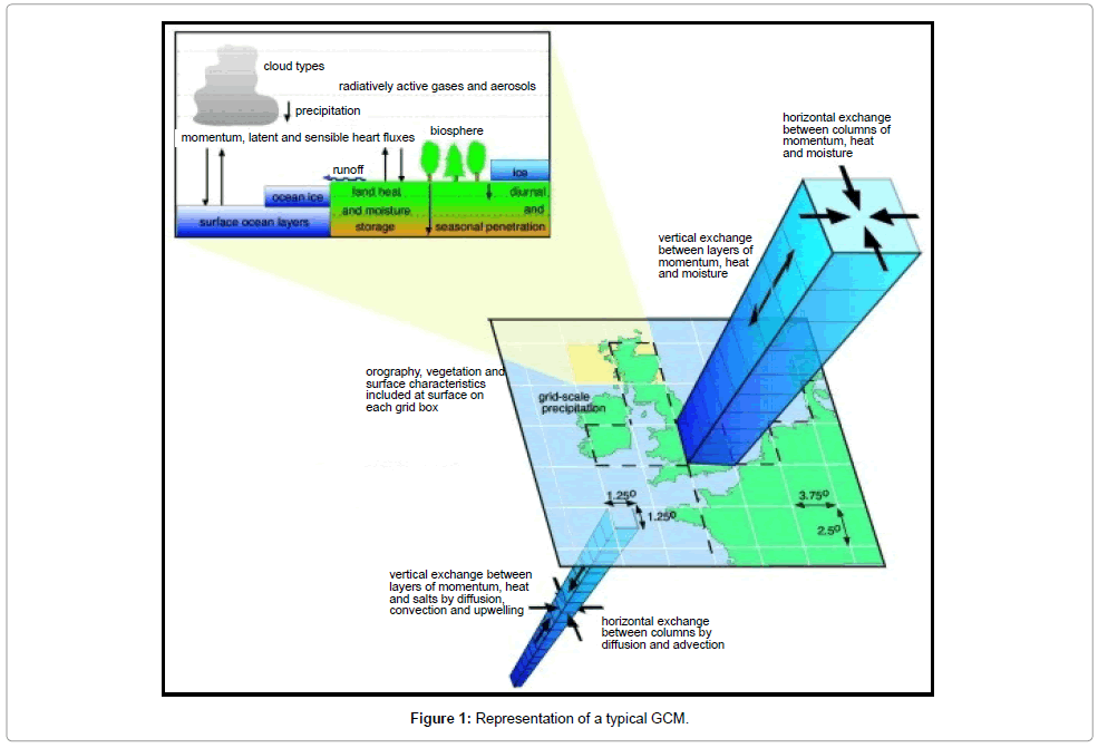
Figure 1: Representation of a typical GCM.
However, it is widely recognized that there are uncertainties in these climate change scenarios and these must be taken into account while assessing the impacts and vulnerability. Moreover, the coarse resolution of the GCMs prohibits their direct use at local or regional scales. Most river basins are of the same order of magnitude or even smaller than the grid dimensions adopted in simulations with GCMs. Hence, the results from a GCM have to be downscaled to predict the local responses better. Dynamical downscaling of climate change projections from GCMs for assessing the impacts on hydrology has received relatively little attention in India [3,4]. A Regional Climate Model (RCM) is the best tool for dynamical downscaling of climate features for making predictions for a particular region [5]. The output of RCMs can be used as input to hydrologic models in order to investigate the impact of predicted climate change on hydrologic processes. Hydrologic models are widely used as a decision making tool at the catchment scale [6]. These models provide a cost effective means of evaluating the best alternative management plan within a watershed. Quantitative estimation of the impact of climate change on hydrology is helpful in identifying potential water resource problems and making better planning decisions. Thus region-specific assessment of the anticipated impacts of climate change on water resources has emerged as an active area of research [7].
Changes in temperature and precipitation patterns consequent to climate change are expected to affect the spatial and temporal distribution of water resources. Linsley [8] identified determination of the response of a catchment to climate change as the most serious problem facing water resource managers. Nemec [9] analyzed the sensitivity of water resource systems to climate variation by performing simulations in a deterministic framework. The impact of climate change on stream flow in arid and humid basins was investigated. Estimates of freshwater resources in the post climate change period are expressed in terms of mean annual river discharges [10,11]. In its latest report, the IPCC states that long term studies have already shown the adverse effects of increased temperature on physical and biological systems in many parts of the world [1]. GCM predictions of rainfall and temperature changes are often associated with large uncertainties [12]. GCMs predict a stronger effect of global warming in mountain regions compared to lowlands, due to a decreasing lapse rate [13].
Assessment of vulnerability is performed by estimating the impacts of climate change, which, in turn, are often based on scenarios of future climate. The IPCC published a new set of emission scenarios in the Special Report on Emissions Scenarios (SRES) [14] to serve as the basis for assessment of future climate. Among all the SRES scenarios, four marker scenarios (A1, A2, B1 and B2) are by far used the most often [15]. The A1 and B1 scenarios emphasize ongoing globalization and project a homogeneous world, while the A2 and B2 scenarios lay emphasis on social, economic, and environmental development on regional and local basis and project a heterogeneous world. In this study, the scenarios A2 and B2 were adopted for investigating the impact of climate change on watershed hydrology. The A2 scenario projects high population growth and slow economic and technological development, while the B2 scenario projects slower population growth, rapid economic development, and lays more emphasis on environmental protection. Emission of Greenhouse Gases (GHGs) and other driving forces, for use in climate simulations using GCMs, were quantified in the Fourth Assessment Report of the IPCC [1].
Climate models predict a stronger effect of global warming in mountain regions compared to lowlands, due to a decreasing lapse rate. In these regions, the projections of GCMs are of limited value, and appropriate downscaling techniques should be applied to obtain climate change data needed to drive hydrologic models. Although many methods for downscaling large scale climate projections have emerged, very few of these methods have been implemented in complex regions such as tropical mountain areas. Application of statistical downscaling methods is hindered by the lack of long term precipitation records needed to fit statistical models of precipitation occurrence and the amount of precipitation. Also, the density of rain gauges is generally low. Although many methods for downscaling large scale climate projections have emerged, very few methods have been implemented in tropical mountain areas [16]. An alternative is to use dynamical downscaling methods [16], which is represented in Figure 2.
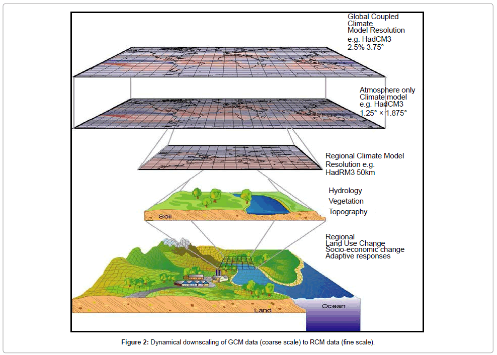
Figure 2: Dynamical downscaling of GCM data (coarse scale) to RCM data (fine scale).
Dynamical downscaling employs high resolution Regional Climate Models (RCMs) to represent global or regional sub-domains, and uses either observed or lower resolution coupled Atmosphere Ocean Global Climate Model (AOGCM) data as boundary conditions [1]. Dynamical downscaling has the potential for capturing mesoscale nonlinear effects and providing coherent information among multiple climate variables. The models used for dynamical downscaling are formulated using physical principles and they credibly reproduce a broad range of climate around the world, thereby enhancing confidence in their ability to downscale realistically future climates [1] These models are applied to certain periods of interest, driven by Sea Surface Temperatures (SSTs) and also boundary conditions along the lateral (atmospheric) boundaries (for example, winds and temperatures). According to Wang [17] dynamical downscaling is able to improve climate simulation at regional scales, especially in regions where land surface characteristics regulate the regional distribution of climate variables. It has facilitated improvement of our understanding of various climate processes. Large number of variables at high spatial and temporal scale is available from dynamical downscaling simulations which employ physicallybased models. But the models employed for dynamical downscaling are however computationally demanding and therefore only a limited number of scenario runs are possible. The number of hydrological impact studies using dynamical downscaling method has increased significantly in recent years [18].
Results and Discussions
Global assessment of water resources indicate that it will be subjected to an increasing stress projected in the context of predicted climate change and population growth scenarios in many parts of the world [19]. Higher temperatures and lower precipitation would lead to reduced water supplies and increased water demands; this might cause deterioration in the quality of water in freshwater bodies, exerting severe strain on the already fragile balance between supply and demand in many countries [20]. The expected changes in climate under various climate change scenarios are predicted using Global Climate Model (GCM) simulations and these have been used to assess the impact of climate change on water resources. Studies have shown that climate change impacts on water resources may differ from region to region depending on the regional geographic characteristics and climate [19]. Even where precipitation might increase, there is no guarantee that it would occur at a time of the year when it could be useful. In addition, some of these studies revealed that there is a likelihood of increased flooding [3]. Any rise in sea level will cause intrusion of salt water into estuaries, small islands and coastal aquifers and flooding of low-lying coastal areas; putting low-lying countries at great risk [21]. A Regional Climate Model (RCM) is the best tool for dynamic downscaling of climate data from the output of a Global Climate Model (GCM) and enables making predictions for a particular region. Some examples of RCMs used are COSMO model in Climate Mode (CCLM), HIRHAM (based on a subset of the HIRLAM and ECHAM models), REMO (Regional Model) and Providing Regional Climates for Impacts Studies (PRECIS). In India, dynamical downscaling has been implemented by the Indian Institute of Tropical Meteorology, Pune using the RCM, PRECIS. This model has depicted the surface climate over the Indian region, particularly the summer monsoon precipitation, both in terms of mean and extremes reasonably well [21].
The Hadley Centre for Climate Prediction and Research has developed a flexible RCM, PRECIS (Providing Regional Climates for Impacts Studies), to provide a practical tool to make projections of national patterns of climate change and hence estimate the possible impacts and assess vulnerability. PRECIS is an atmospheric and land surface model of limited area and high resolution. It has the provision to include the sulphur cycle and can generate outputs for more than 150 variables. The IITM (Indian Institute of Tropical Meteorology) located at Pune, India in collaboration with the Hadley Centre has developed future scenarios for India. PRECIS model data has been validated extensively at both regional and catchment scales in different parts of the world and represents well the mean climate [2]. RCMs are generally run for a recent period and the results are compared with observed values for the same period. Normally, PRECIS runs with 50km horizontal resolution for the present climate (1961–1990) using different base-line Lateral Boundary Conditions (LBCs) and for future scenarios (2070–2100) based on the Special Report of Emission Scenarios (SRES) of the Intergovernmental Panel for Climate Change (IPCC). It is advisable to validate two or more climate models before choosing the most appropriate model for use in scenario generation for a particular region. Model (PRECIS) simulations under scenarios of increasing greenhouse gas concentrations and sulphate aerosols indicate marked increase in both rainfall and temperature over India in the 21st century. According to the downscaled climate projections by PRECIS for the Indian peninsular region, an average temperature increase between 1ºC in winter and 2ºC in summer and an average general decrease in precipitation of 10-20% are predicted. However this decrease in precipitation is not uniform throughout the year; a decrease of up to 10% in spring, between 10 to 15% in autumn, and an increase of 10-20% in winter [21]. The change in rainfall under the B2 scenario is relatively less compared to that under the A2 scenario. There are substantial spatial differences in the projected changes in rainfall [21]. The maximum expected increase in rainfall (10 to 30%) occurs over central India. There is no clear evidence of any substantial change in the year-to-year variability of rainfall over the next century [21]. Surface air temperature shows comparable increasing trends in the A2 as well as B2 scenarios. The temperatures are projected to increase by as much as 3°C to 4°C towards the end of the 21st century. Warming is projected to be widespread over the entire country and relatively more pronounced over the northern parts of India [21].
By providing more realistic simulations of present and future climate change compared to the coarse resolution GCMs, RCMs can facilitate a better understanding of the impact these changes on water resources. RCMs are based on the same model physics as the driving GCM and do not require a dense observational network as is needed for statistical downscaling. However, careful model validation with filed observations is a necessary pre-requisite to ensure that RCMs accurately portray present day spatio-temporal climate variability, in particular along mountain ranges, where orography strongly affects seasonal distributions of precipitation. A major drawback of RCMs is that they are computationally expensive and rather complex to implement. Therefore, they are typically not run using dataset from the entire range of available models; simulations are based on just one or two driving GCMs. This significantly complicates uncertainty assessments. Structural deficiencies of the model and errors in the forcing data can also propagate from the driving GCM to the RCM and increase uncertainties.
Conclusion
Climate change is expected to exacerbate current stresses on water resources resulting from population growth, economic factors and land use changes, including urbanization. On a regional scale, mountain snow packs, glaciers and small ice caps play a crucial role in freshwater availability. Widespread mass losses from glaciers and reduction in snow cover, reported in recent times, are projected to accelerate throughout the 21st century, reducing water availability, hydropower potential, and changing seasonality of flows in regions supplied by melt water from major mountain ranges, where more than one-sixth of the world population currently lives. Runoff is projected with high confidence to increase by 10 to 40% by mid-century at higher latitudes and in some wet tropical areas, including populous areas in East and South-East Asia due to increase in rainfall and lower rates of evapotranspiration. Also, it is projected to decrease by 10 to 30% over some dry regions at midlatitudes and dry tropics, due to decrease in rainfall and higher rates of evapotranspiration. There is also high confidence in the projection that many semi-arid areas will suffer a reduction in water resources due to climate change. Drought-affected areas are projected to increase in extent, with the potential for adverse impacts on multiple sectors, including agriculture, water supply, energy production and health. Regionally, large increase in irrigation water demand is projected as a result of climate change.
In Asia, it is estimated that the mean continental surface temperatures increased by approximately 0.7°C over the 20th century and a further warming of 0.2-0.5°C per decade is predicted for 2070- 2100. This rise in surface air temperatures is expected to significantly affect terrestrial hydrology, an integral part of climate system. One of the most severe consequences of climate change will be the alteration of the hydrological cycle, and this in turn, will affect the quantity and quality of regional water resources. Since hydrologic conditions vary from region to region, the influence of climatic change on local hydrological processes will likely differ between localities, even under the same climatic scenarios. Studies in recent years have shown important regional water resources vulnerabilities to changes in both temperature and precipitation patterns. It is primarily at the local and regional scales that policies could be evolved and technical measures could be taken to avoid or reduce the negative impacts of climatic change on the natural environment and society. Understanding the possible impacts of climate change on water resources is of utmost importance for ensuring its appropriate management and utilization.
References
- IPCC-Intergovernmental Panel on Climate Change (2007) The Physical Science Basis. Contribution of Working Group I to the Fourth Assessment Report of the Intergovernmental Panel on Climate Change. Climate Change, Cambridge University Press, Cambridge, UK.
- Gleick PH (1987) Regional Hydrologic Consequences of Increases in Atmospheric CO2 and Other Trace Gases. Climate Change 10: 137-161.
- Gosain AK, Sandhya R, Debajit B (2006) Climate change impact assessment on hydrology of Indian river basins. Current Sci 90: 346-353.
- Ghosh S, Mujumdar PP (2008) Statistical downscaling of GCM simulations to stream flow using relevance vector machine. Adv Water Res 31: 132-146.
- Jones RG, Noguer M, Hassell DC, Hudson D, Wilson SS, et al. (2004)Generating High Resolution Climate Change Scenarios Using PRECIS. Met Office Hadley Centre: Exeter, UK.
- Lenhart T, Eckhardt K, Fohrer N, Frede HG (2002) Comparison of two different approaches of sensitivity analysis. Phys Chem Earth 27: 645-654.
- Brekke LD, Norman LM, Kathy EB, Quinn NW, Dracup JA (2004) Climate change impacts uncertainty for water resources in the San Joaquin River basin, California. J Am Water Res Assoc 40: 149-164.
- Linsley RK, Kohler MA, Paulhus JL, Wallace JS(1982) Hydrology for engineers. McGraw Hill, New York, USA.
- Nemec J, Schaake JS (1982) Sensitivity of water systems to climate variation. J Hydrol 27: 327-343.
- Legesse D, Vallet-Coulomb C, Gasse F(2003) Hydrological response of a catchment to climate and landuse changes in tropical Africa: case study South Central Ethiopia. J Hydrol 275: 67-85.
- Messager C, Galle H, Brasseur O, Cappelaere B, Peugeot C, et al. (2006) Influence of observed and RCM-simulated precipitation on the water discharge over the Sirba basin, Burkina Faso, Niger. Climate Dynam 27: 199-214.
- Zierl B, Bugmann H (2005) Global change impacts on hydrological processes in Alpine catchments.Water Resource Res 41: 396-408.
- Bradley RS, Vuille M, Diaz HF, Vergara W (2006) Threats to water supplies in the tropical Andes. Sci 312:1755-1756.
- Nakicenovic N, Alcamo J, Davis G, de Vries B, Gaffin S, et al. (2000) IPCC Special Report on Emissions Scenario. Cambridge, Cambridge University Press, UK.
- Van Vuuren PD, O’Neill BC (2006)The consistency of IPCC’s SRES scenarios to recent literature and recent projections. Climatic Change 75: 9-46.
- Maraun D, Wetterhall F, Ireson AM, Chandler RE, Kendon EJ, et al. (2010). Precipitation downscaling under climate change. Recent developments to bridge the gap between dynamical models and the end user. Rev Geophy 48: 3.
- Wang B, Kang IS, Lee JY (2004) Ensemble simulations of Asian–Australian monsoon variability by 11 AGCMs. J Climate 17: 803-818.
- Viviroli D, Archer DR, Buytaert W, Fowler HJ, Greenwood GB, et al. (2010) Climate change and mountain water resources: overview and `recommendations for research, management and politics. Hydrol Earth Sys Sci 7: 2829-2895.
- Arnell NW, Liu C, Compagnucci R, da Cunha L, Hanaki K, et al. (2001) Hydrology and water resources. In: Climate Change 2001: Impacts, adaptation, and vulnerability. Cambridge University Press, Cambridge, UK.
- Milly PCD, Dunne KA, Vecchia AV (2005)Global pattern of trends in streamflow and water availability in a changing climate.Nature438: 347-350.
- Rupa KK, Sahai AK, Krishna KK, Patwardhan SK, Mishra PK, et al. (2006) High-resolution climate change scenarios for India for the 21st century. Current Sci 90: 334-345.
Citation: Raneesh KY (2014) Impact of Climate Change on Water Resources. J Earth Sci Clim Change 5: 185. DOI: 10.4172/2157-7617.1000185
Copyright: ©2014 Raneesh KY. This is an open-access article distributed under the terms of the Creative Commons Attribution License, which permits unrestricted use, distribution, and reproduction in any medium, provided the original author and source are credited.
Select your language of interest to view the total content in your interested language
Share This Article
Recommended Journals
Open Access Journals
Article Tools
Article Usage
- Total views: 23239
- [From(publication date): 3-2014 - Aug 29, 2025]
- Breakdown by view type
- HTML page views: 18001
- PDF downloads: 5238