Interpreting of Fault Activation with New High Resolution Digital Elevation Model with Himalayan and Azad Kashmir
Received: 19-Jan-2019 / Accepted Date: 14-Feb-2019 / Published Date: 20-Feb-2019
Abstract
In the research area compressional stresses caused by the collision of Indian and Eurasian plates developed the northwest- southeast trending faults which are Riasi Fault (RF), Palandri Fault (PF), Godri Badshah Fault (GBF) and Chhechhan Fault (CF). The objective of research was to interpret the Fault activation based on Geo-hazard parameters includes active faults, slope gradient and Geo-hazard zonation on the basis of Geographical Information System, restrain with the previously known geological and structural information. Digital Elevation Model use to contemplate the faults, slopes, topography, contours, watershed, hill shade, aspect, and stream network. Faults activation is also mark based on geomorphological features, outcrops and linear landslides. It’s required to creating a new high-resolution DEM using GIS Software Arc GIS v10.2 with its 3D Analyst extension. The faults are reverse in nature and have Strike Slip movement bearing Fault gouge and crushing. The folds in research area are open to gentle and northeast southwest vergent. Mapping disclose the well exposure of Siwalik group of Early Miocene (Tm Formation) to Late Miocene (Tdp Formation) rocks in the research area.
Keywords: Restrain; Contemplate; Gouge; Vergent; Exposure
Introduction
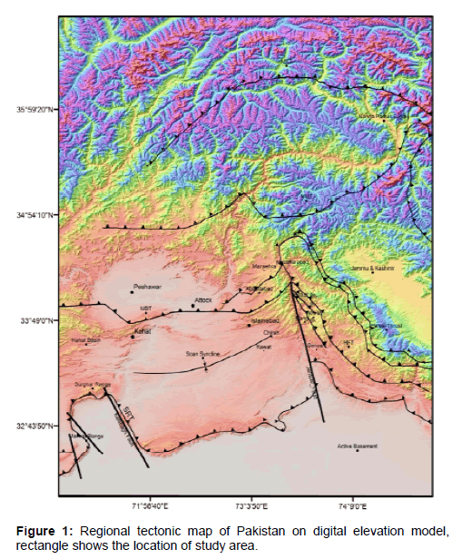
The research area lies in the Sub-Himalayas. The fold and thrust procedure are the result of Indian and Eurasian collision in Himalayan territory. The project area is bounded by Main Boundary Trust (MBT) to the East, Jhelum Fault (JF) to the West, Salt Range Thrust (SRT) to the South and it lies in the south of Bagh Basement Fault (BBF) (Figure 1). The area is the part of Sudhnoti and Kotli districts of Azad Kashmir, Pakistan.
The major folds in the area are Androt Syncline, Mangriot Anticline, Namb Peprian Syncline, Palandri Anticline, Dhardarch Syncline, Chhechhan Anticline and Holar Syncline. The northern part of study area has been separated by northwest-southeast trending faults and folds and are related to Himalayan compression. These faults are Riasi Fault (RF), Palandari Fault (PF), Godri Badshah Fault (GBF) and Chhechhan Fault (CF). The Riasi Fault is the major fault passing through the area. The geo-morphological features proposed that Riasi Fault, Palandari Fault, Godri Badshah Fault and Chhechhan Fault are active.
Stratigraphy
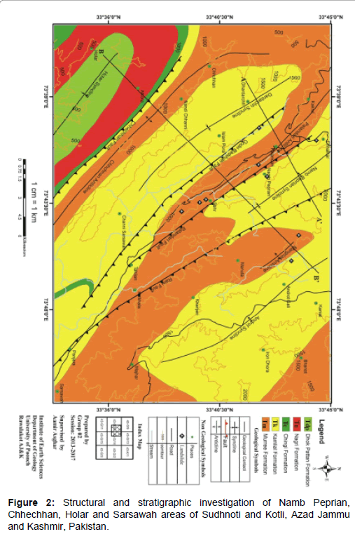
The research area lies in the sub-Himalayas. It is essentially composed of Miocene to Pleistocene molassic sediments derived from the erosion of Himalayas and these molasse deposits, known as the Murree and Siwaliks Formations are internally folded and imbricated [1]. Stratigraphic sequence of research area includes the Murree Formation, Kamlial Formation, Chingi Formation, Nagri Formation and Dhok Pathan Formation (Figure 2).
After successful surgical implant of the cfLVAD and a primarily prophylactic intracutaneous defibrillator to prevent ventricular arrhythmia, organ functions improved, and the general state of health ameliorated appreciably. The right ventricular function represented itself as satisfactory. Twenty days after cfLVAD implantation the patient was discharged to a rehabilitation clinic.
Murree formation
The "Mart Group" of Wynne (1874), "Murree Beds" of Lydekker (1876) and "Murree Series" of Pilgrim (1910) have been formally named Murree Formation by the Stratigraphic Committee of Pakistan. The series of alternate beds of sandstone, siltstone and shale with subordinate conglomerates [2-5].
In the area, the Murree Formation consists of light greenish grey calcareous cyclic sequence of sandstone, clay and layers of conglomerates (Figure 3). It has transitional contacts with overlying Kamlial Formation and underlying Kuldana Formation. Early Miocene is the age of Murree formation [6].
Kamlial formation
The “Kamlial beds” of Pinfold (1928) have been named as Kamlial Formation by Startigraphic Committe of Pakistan [7,8]. The Middle to Late Miocene Kamlial Formation that largely consists of sandstone and interbedded clay/mudstone sequences is exposed in the southwestern part of the Kohat plateau, which constitutes the westernmost extension of the Himalayan Foreland Basin [9].
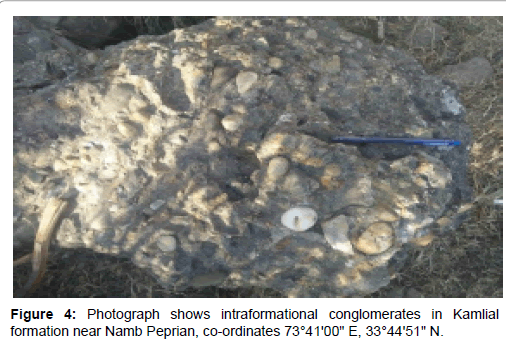
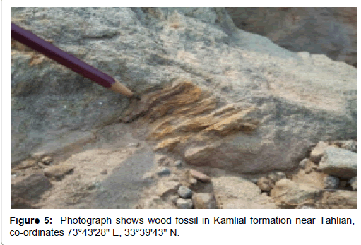
In the area, Kamlial Formation consist of dark brick-red sandstone and intraformational conglomerats (Figure 4). Wood fossils and leaves prints are also present near Tahlian (Figure 5). The lower gradational contact of Kamlial Formation with Murree Formation and the upper contact with the Chingi Formation. The age of Kamlial Formation is Middle to Late Miocene [8].
Chingi formation
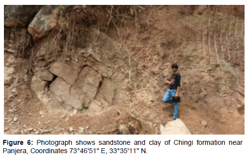
The name Chinji Formation was recognized by the Stratigraphic Committe of Pakistan [8]. Lewis further work is on it [10]. In the study area Chingi Formation is not well exposed but small beds of red clay and brownish grey sandstone (Figure 6) are disclose near Panjera and Nandi Chhanni. The upper contact with Nagri Formation and lower contact of Chingi Formation with Kamlial Formation are gradational. Middle to Late Miocene is the age of Chingi Formation [8].
Nagri formation
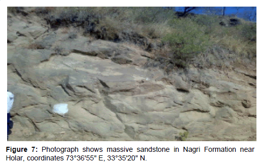
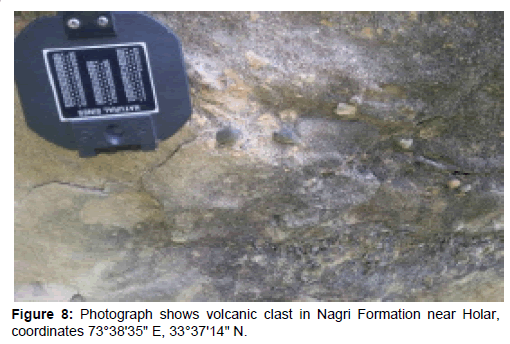
Lewis gives the name “Nagri formation” accepted by the Stratigraphic Committe of Pakistan [10]. In the area, the Nagri Formation consists of sandstone, clay and layers of conglomerates. The sandstone is compacted massive and medium to coarse grained. The color of sandstone is grey, light grey and greenish grey (Figure 7). Chingi Formation exposed in Atkora and Holar. The volcanic clasts are also present in Nagri Formation (Figure 8). The upper contact with Dhok Pathan Formation and lower contact with Chingi Formation are gradational. Early Paleocene is the age of Nagri Formation [8].
Dhok pattan formation
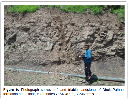
The Stratigraphy Committe of Pakistan accepted the name Dhok Pathan Formation given by Lewis [10]. In research area, the Dhok Pathan Formation exposed in Holar and consist of sandstone, clays and compacted conglomerate level. The sandstone in Dhok Pathan Formation is relativel soft with respect to Nagri Formation (Figure 9). The sandstone is grey, light grey and reddish brown. Falser bedding are characteristic features of Dhok Pathan Formation. The lower and upper contact contact of Dhok Pathan Formation with Nagri Formation and Soan Formation are gradational. The age of Dhok Pathan Formation is Early to Middle Pliocene Pascoe [11].
Structure
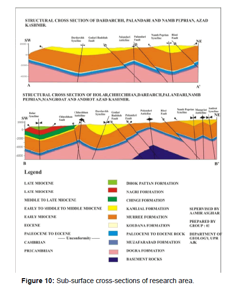
Major Structures in the research area are folds and faults. The northern part of study area has been separated by northwest-southeast trending faults and folds and are related to Himalayan compression. These folds are open to gentle and northeast southwest vergent (Figure 10 and Table 1).
| Folds | Attribute of Bedding | Plunge and Trend of Fold Axis | Attitude of Axial Plane | Intern Limb angle | Type of Fold | |
|---|---|---|---|---|---|---|
| Northeastern Limb | Southwestern Limb | |||||
| Androt Syncline | N45ᵒW/35ᵒNE | N48ᵒW/40ᵒSW | 2ᵒ/133ᵒ | N47ᵒW/87ᵒNE | 105ᵒ | Open |
| Mangriat Anticline | N45ᵒW/35ᵒNE | N31ᵒW/32ᵒSW | 4ᵒ/322ᵒ | N39ᵒW/88ᵒSW | 113.6ᵒ | Open |
| Namb Peprian Syncline | Northwestern Part N45ᵒW/15ᵒNE |
N46ᵒW/30ᵒSW | 1ᵒ/134ᵒ | N46ᵒW/82ᵒNE | 135ᵒ | Gentle |
| Southwestern Part N40ᵒW/26ᵒNE |
N31ᵒW/32ᵒSW | 2ᵒ/325ᵒ | N36ᵒW/87ᵒNE | 122.2ᵒ | Gentle | |
| Palandari Anticline | Northwestern Part N42ᵒW/32ᵒNE |
N51ᵒW/30ᵒSW | 3ᵒ/134ᵒ | N47ᵒW/89ᵒSW | 118.2ᵒ | Open |
| Southwestern Part N40ᵒW/26ᵒNE |
N51ᵒW/30ᵒSW | 3ᵒ/134ᵒ | N46ᵒW/88ᵒNE | 124.3ᵒ | Gentle | |
| Dardarchh Syncline | Northwestern Part N24ᵒW/25ᵒNE |
N26ᵒW/15ᵒSW | 1ᵒ/156ᵒ | N25ᵒW/85ᵒSW | 140ᵒ | Gentle |
| Southwestern Part N44ᵒW /65ᵒNE |
N51ᵒW/30ᵒSW | 4ᵒ/134ᵒ | N36ᵒW/17ᵒNE | 94.8ᵒ | Open | |
| Chhechhan Anticline | N44ᵒW/65ᵒNE | N58ᵒW/55ᵒSW | 12ᵒ/130ᵒ | N17ᵒE/12ᵒNW | 118.6ᵒ | Open |
| Holar Syncline | N51ᵒW/20ᵒNE | N53ᵒW/18ᵒSW | 1ᵒ/128ᵒ | N38ᵒW/89ᵒSW | 142ᵒ | Gentle |
Table 1: Folds in research area.
Faults
The rocks in the research area are highly signifier due to the collision of Indian Plate and Eurasian Plate in the Himalayan tertiary [12]. In the study area compres-sional stresses caused by the collisional of Indian and Eurasian plates developed the northwest- southeast trending faults which are Riasi Fault, Palandri Fault, Ghodri Badshah Fault and Chhechhan Fault.
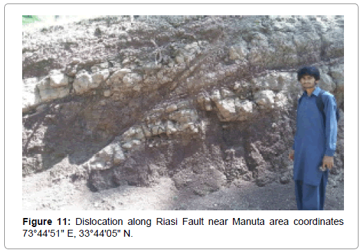
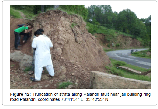
Riasi fault: The >60 km-long Riasi fault system is the southeastern most segment of a seismically active regional fault system that extends more than 200 km stepwise to the southeast from the Balakot-Bagh fault in Pakistan into northwestern India [13]. In study area Riasi Fault is northwest-southeast trending fault and runs from the Manuta (Figure 11) and west of the Magnriot Anticline and to east of the Namb Peprian Syncline. It is NE dipping fault and Kamlial Formation thrusted over the Murree Formation in some areas (Figure 12). It runs from Murree Formation near Kulkhala and Panjera.
The fault is mark based on dislocation, fault gouge, shearing, crushing and bending of streams in the research area (Figure 11). Bending of streams and dislocation suggested that the hanging wall block moves upwards, and foot wall block moves downwards.
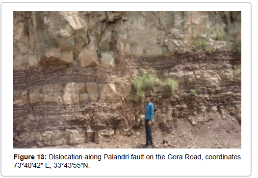
Palandri fault: The Palandri Fault is a northwest-southeast trending and northeast dipping reverse fault. It is an intraformational fault that runs in the Murree Formation (Figure 2). It runs from west of the Namb Peprian Syncline and east of the Palandri Anticline and it passes from Sehr area. In some areas the attitude of fault plane is N60°W/68°NE. The fault is mark based on Truncation of strata, dislocation, gouge, tilting of trees, shearing and crushing in the research area (Figures 12 and 13).
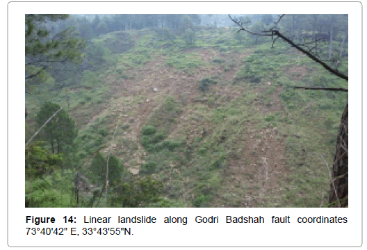
Godri Badshah fault: The Godri Badshah Fault is a major fault passing through near Channi and Sarsawah areas. The Godri Badshah Fault is northwest-southeast trending fault. In the northwestern part Murree Formation is thrusted over the Kamlial Formation and in southeastern part Kamlial Formation thrusted over Chinji Formation. The folding, banding of streams, tilting of trees, crushing and linear landslides are present along the fault plane (Figure 14).
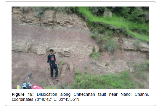
Chhechhan fault: The Chhechhan Fault is a major fault passing through the Chhechhan area. The Chhecchan Fault is northwestsoutheast trending fault. The Kamlial Formation is thrusted over the Chingi Formation. The attitude of fault plane is N41°W/62°NW. The crushing, dislocation and folding are present along the fault plane (Figure 15).
Methodology
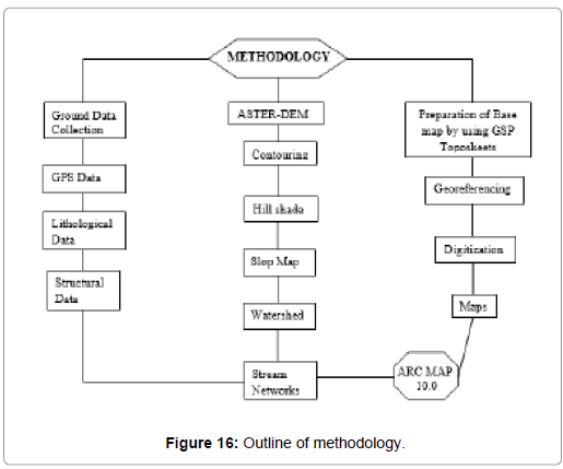
Digital Elevation Model (DEM) of Shuttle Radar Topography Mission (SRTM) of 30 meter spatial resolution will be freely downloaded from United States Geological Survey (USGS) website (http://earthexplorer.usgs.gov/). Physical parameters i.e., slope angle, elevation, aspect, internal relief, slope length, drainage pattern, stream density will be extracted from SRTM DEM in ArcGIS environment.
Fault activation is also marked on the basis of Gouge material, crushing and shearing, tilting of trees, outcrops and geomorphological features. This required creating a new high-resolution DEM using GIS Software ArcGIS v10.2 with its 3D Analyst extension (Figure 16).
Discussion
Northwest Himalayan fold and thrust belt is baccilar due to collision of Indian and Eurasian plate. The Indian plate is presently poignant at the rate of 3.7 mm/year with respect of Eurasian plate. The uninterrupted movement and collision of plates wrought the structural geometry of the Himalayan orogenic belt. The major syntaxial crook in the area is the Hazara Kashmir Syntaxis. The study area posture along the southern part of Hazara Kashmir Syntaxis. This area is the component of Kashmir foreland-fold-and-thrust belt, which is an active belt. This foreland fold-and-thrust belt is highly distorted, sheared and fractured. The Early Miocene to Late Miocene sedimentary rock sequence is uncovered in the project area. This molasse sequence comprise the Murree, Chingi, Nagri and Dhok Pathan Formation. This molasse sequence is formed by the uplift and erosion of Himalayas and deposition of these sediments in the southward migrations foreland basin (Table 1).
The major folds of the area are Androt Syncline, Mangriot Anticline, Namb Peprian Syncline, Palandari Anticline, Dhardarchh Syncline, Chhchhan Anticline and Holar Syncline. Mostly folds in the study are northwestern and southeastern trending, northeastern or southwest plunging and open to gentle. The major faults of the area are Riasi Fault, Palandri Fault, Godri Badshah Fault and Chhechhan Fault. The Riasi Fault is the major fault of project area. It is between the Murree Formation and Kamlial Formation. The rocks are fractured and crushed along Riasi Fault. Tilting of trees along the Raisi Fault shows that the fault is an active fault. The Palandri Fault is well exposed in Palandri area. The imbricate style of thrusting is dominant in the area.
Conclusion
In Conclusion, the purpose of our research is to interpret the Fault activation based on Geo-hazard parameters includes active faults, slope gradient and Geo-hazard zonation based on Geographical Information System, restrain with the previously known geological and structural information. Digital Elevation Model use to contemplate the faults, slopes, topographic, contours, watershed, hill shade, aspect, and stream maps. Fault activation is also marked on the basis of Gouge material, crushing and shearing, Tilting of trees, outcrops and geomorphological features. This required creating a new high-resolution DEM using GIS Softwear ArcGIS v10.2 with its 3D Analyist extension. In the research area compressional stresses caused by the collision of Indian and Eurasian plates developed the northwest- southeast trending faults which are Riasi Fault (RF), Palandri Fault (PF), Godri Badshah Fault (GBF) and Chhechhan Fault (CF). The faults are reverse in nature and have Strike Slip movement bearing Fault gouge and crushing. The folds in research area are open to gentle and northeast southwest vergent. Mapping disclose the well exposure of Siwalik group of Early Miocene (Tm Formation) to Late Miocene (Tdp Formation) rocks in the research area.
References
- Latif MA (1970) Explanatory notes on the geology of southeastern Hazara to accompany the revised geological map. Jahrbuch der Geologischen Bundesanstalt, Sonderband 15: 5-20.
- Lydekker R (1883) The geology of Kashmir and Chamba territories and the British district of Kaghan. Mem Geol Surv Ind 22: 1-344.
- Pilgrim GE (1913) The correlation of Siwalik with mammal horizons of Europe. Rec Geol Surv Ind 43: 264-326.
- Bell FG (2007) Engineering Geology (2nd edn) Butterworth-Heinemann, UK. pp: 581.
- Wadia DN (1928) The geology of the Poonch State (Kashmir) and adjacent portion of the Punjab. Mem Geol Surv Ind, 51: 185-370.
- Pinfold ES (1918) Notes on structure and stratigraphy in the North-West Punjab. Rec Geol Surv Ind 49: 137-160.
- Shah SMI (1977) Stratigraphy of Pakistan: Geological Survey of Pakistan Memoirs. Islamabad, Pakistan. Geol Surv Pakistan 12: 138.
- Ullah K, Arif M, Shah MT (2015) Petrography and geochemistry of the Kamlial Formation, southwestern Kohat plateau, Pakistan: implications for paleoclimate of the Western Himalayas. Turkish J Earth Sci 24: 276-288.
- Lewis GE (1937) A new Siwaliks correlation (Ind). Am J Sci 195: 191-204.
- Pascoe EH (1920) Petroleum in the Punjab and northwest Frontier Province. Geol Surv Ind 20: 330-489.
- Aitchison JC, Ali JR, Aileen MD (2007) When and where did the Asia collide?. J Geophys Res 112 (B5).
- Gavillot Y, Meigs A, Yule D, Heermance R, Rittenour T, et al. (2016) Shortening rate and Holocene surface rupture on the Riasi Fault sstem in the Kashmir Himalaya: Ative thrusting within the Northwest Himalayan orogenic wedge. Geol Soc Am Bull 128: 1070-1094.
Citation: Khan N, Hussain MA (2019) Interpreting of Fault Activation with New High Resolution Digital Elevation Model with Himalayan and Azad Kashmir. J Earth Sci Clim Change 10:509.
Copyright: © 2019 Khan N, et al. This is an open-access article distributed under the terms of the Creative Commons Attribution License, which permits unrestricted use, distribution, and reproduction in any medium, provided the original author and source are credited.
Select your language of interest to view the total content in your interested language
Share This Article
Recommended Journals
Open Access Journals
Article Usage
- Total views: 4583
- [From(publication date): 0-2019 - Dec 13, 2025]
- Breakdown by view type
- HTML page views: 3646
- PDF downloads: 937

