Land Use Change Detection Using Remote Sensing Technology
Received: 31-Aug-2018 / Accepted Date: 10-Oct-2018 / Published Date: 31-Oct-2018 DOI: 10.4172/2157-7617.1000496
Keywords: Land use change; Remote sensing; Upper Rib watershed; ERDAS Imagine
Introduction
Land and water resources degradation are the major problems in the Ethiopian highlands. Poor land use practices and improper management systems have played a significant role in causing high soil erosion rates, sediment transport and loss of agricultural nutrients [1]. The effect of land cover change has caused the loss of fresh and portable water needs loss in the area alongside occupational dislocation [2]. The results in the loss of productivity, loss of organic matter rich surface soil (topsoil) is known to decrease soil quality which in turn reduces productivity [3]. Most of the land cover changes of the present and the recent past are due to human actions. Man, kind’s presence on the Earth and his modification of the landscape has had sound effect upon it [4]. Land use/cover change involves either direct or indirect modification of the natural habitat and impact on the ecology of the area [5]. Population pressure has been found to have negative effect on land use-cover of the area [6,7]. These problems are currently taking place in the upper Guna Tana landscape, where sedimentation patterns in downstream areas have significantly changed mainly due to land use change. In addition, seasonal, extreme meteorological phenomena have caused significant soil losses and sediment deposited in newly built Ribb irrigation reservoir.
Land use/land cover (LULC) changes are major issues of global environment change. The satellite remote sensing data with their repetitive nature have proved to be quite useful in mapping land use/ land cover patterns and changes with time. Quantification of such changes is possible through GIS techniques even if the resultant spatial datasets are of different scales/ resolutions [8]. Such studies have helped in understanding the dynamics of human activities in space and time. Land use refers to man’s activities. During the past millennium, humans have taken an increasingly large role in the modification of the global environment. With increasing numbers and developing technologies, man has emerged as the major, most powerful, and universal instrument of environmental change in the biosphere today [9]. Change detection is the process of identifying differences in the state of a feature or phenomenon by observing it at different times [10]. Change detection is useful in many applications related to land use and land cover (LULC) changes, such as shifting cultivation and landscape changes [11], land degradation and desertification [12,13] coastal change and urban sprawl Image pre-processing [13], urban landscape pattern change [14,15] deforestation [16] quarrying activities [17], and landscape and habitat fragmentation and other cumulative changes [18]. Land cover changes have been influenced by both the increase and decrease of a given population [19]. In most developing countries like Ethiopia population growth has been a dominant cause of land use and land cover change than other forces [20]. There is a significant statistical correlation between population growth and land cover conversion in most of African, Asian, and Latin American countries [21]. Due to the increasing demands of food production, agricultural lands are expanding at the expense of natural vegetation and grasslands [19]. Soil erosion and land degradation as well as depletion of the natural resources base in Amhara region is mainly attributed among others to population pressure, ineffective soil and water conservation measures, traditional farming systems that involve ploughing of very steep and marginal lands, free grazing, lack of alternative source of income, low community participation and inadequate infrastructure. These problems compounded by other factors related to policies and strategies have aggravated the natural resources depletion and sediment transport. The main objective of this study is to evaluate land use/ land cover dynamic of upper Ribb watershed using remote sensing technology for sustainable management and enhancement of the reservoir water storage capacity and irrigation productivity through providing directions of catchment management.
Research Methodology
Study area description
Ribb dam site is found in South Gonder zone of Amhara National Regional State between Farta Woreda and Ebenat woreda; at a specific geographic grid reference location of 12°02’ 11.11” N and 38°02’ 18.2” E at an altitude of 1869 m.a.s.l. Ribb Watershed is situated mainly in Farta Wereda (with small part engulfing into Ebinat wereda) of South Gonder Zone in Amhara Region. It is located at a distance of 625km north-of Addis Ababa (60km from Bahir Dar town, capital city of the Amhara Region). The landscape area is highly rugged with high (Guna) mountain range on the south eastern, and closely dispersed and their escarpments in the central and northern parts of the watershed, which are dissected deep and narrow bedded gorges and valleys as well as plains on the top of the hills. There also exist gentle slopes on the most hills of upper reaches and middle bodies, which are thoroughly cultivated for annual (cereal) food crops (Figures 1 and 2).

Figure 1: Upper Ribb watershed location map.
Figure 2: Methodology flow-chart.
Data source and method of analysis
Land use is one of the most important factors that affect runoff, evapotranspiration and surface erosion in the watershed. The land use map/satellite images of the study area were obtained from USGS Earth explorer (https://earthexplorer.usgs.gov), Landsat ETM+ image at path (169) and row (52) with the cloud cover less than 10%, spatial resolution of 30 m × 30 m, acquisition date (21-08-2007 and 16-01- 2018). The satellite images were classified based using ground truth points and Google Earth linkage with ERDAS Imagine 2014 software (Figure 3). This is was done to represent the land use according to the specific land cover types such as cultivated, pasture and forest.

Figure 3: Land use land cover map of both 2007 and 2018 in upper Ribb dam watershed.
Land use/land covers classification
The objectives of land use land cover is, to understand the general procedures of land cover classification from satellite images, to conduct land cover classification from the Landsat 7 ETM using Supervised classification, to understand how the image classification accuracy to assesses how well a classification worked and understand how to interpret the usefulness of someone else’s classification
Satellite image data: The satellite images of the study area were downloaded from USGS earth explorer website, https://earthexplorer.usgs.gov/, using the Path and Rows of the study area which are 169 and 52 respectively. The datasets were downloaded considering the time period between 2007 and 2018 having a cloud cover less than 10% to avoid the classification error. And check in “Additional Criteria” option the cloud cover is less than 10%. Finally click on “Result” option to get the satellite images that we want. After click on the Result icon in previous procedure the satellite image will appear. Check land cloud cover will be zero by clicking on MetaData Set icon. Finally download will begin by click on Level-1 Geo TIFF Data Product (252. MB). Because satellite image accuracy is depend on its MB. Finally save the zipped data for further analysis in working directory.
Image pre-processing: Pre-processing of satellite images prior to change detection is essential and has unique goal of establishing a more direct linkage between the data and biophysical phenomena [22]. The methodology adopted for this study took into consideration various image pre-processing operations, including geometric correction, atmospheric correction, image enhancement and interpretation. The downloaded satellite images were pre-processed before the classification has been processed. The images collected has been layer staked. Many images used in IMAGINE cover a large area, while the actual area being studied can only cover a small portion of the image. To save on disk space and processing time, new images representing the watershed were produced, using subset of the entire data set.
Image enhancement: Image enhancement is the process of making an image more interpretable for a particular application. Enhancement makes important features of raw, remotely sensed data more interpretable to the human eye. Enhancement techniques are often used instead of classification techniques for feature extractionstudying and locating areas and objects on the ground and deriving useful information from images.
The image enhancements which has been done in this study were radiometric correction, spectral enhancement and principal component analysis for the enhancement of identification of each of the land cover types. Spectral Enhancement options are image transformation techniques specifically tailored for data containing more than one band. These options can be used to extract new bands of data that are more interpretable to the eye. Generally, these enhanced images are only used in visual analyses, while original images are used for automated analyses [23,24]. In the present study, we applied contrast stretching on the selected images to visually interpret them. Prior to image classification, LULC features were categorized into six broad types: bare land, agricultural lands, urban lands, forest, water bodies and grassland. These six types were identified based on the visual interpretation of the satellite imagery and verified from field inspection. Bare land refers to uncultivated land or land without vegetation cover. Agricultural land refers to areas cultivated with field crops, forage crops, vegetables, or fruit trees.
Image classification: Basically, there are two image classification techniques which are employed for land cover classification. Supervised classification is one of; a method of land cover type classification using the sample polygons (ground truth points) from the known land cover types. The other type of classification is; Unsupervised classification; which is type of land cover classification from the satellite image data when the user doesn't know how many land cover types are present in the field. For this study; supervised type of classification was used using the known ground truth points and by connecting ERDAS Imagine with Google Earth and synchronizing the images. In Supervised Classification, the classification process has been controlled by creating, managing, evaluating, and editing signatures using the Signature Editor. Signatures are specific areas to which the names are assigned for supervised classification. Signatures are used to break the different classes like forest, cultivated, water and the like classes into as many subclasses as per classification requirement. Some tools such as the Signature Editor require were grown using an AOI layer which were created in the layer creation option. To perform complex classifications with signatures that are derived from more than one training method (supervised and/or unsupervised, parametric and nonparametric) merge signatures option was employed. The supervised classification is the most common method in obtaining land use/cover information. In this study, after data preprocessing, a training sample was selected according to spectrum features. Unlike the conventional classifications of land use/cover, the maximum likelihood classification was used to map the land use/cover of watershed. After classifying the image using supervised classification, the accuracy of classification was checked using ground control points.
Results And Discussion
Introduction to land use and land cover
Following the step by step detection and quantification procedures on satellite images, two land use and land cover maps of 2007 and 2018 were produced. Subsequently, spatial analysis was carried out to describe structural land use and land cover patterns, overall land use changes over the time period, and measure the rate of change at the watershed level. The LUC maps of the Ribb watershed for two reference years, and statistical summaries of the different LUC types were presented (Figure 2 and Table 1). Land cover change results were obtained by using ERDAS IMAGINE 2014 from Landsat 7 ETM+ images of 2007 and 2018. Six types of land cover classes have been identified from the satellite images of the area. The identified land cover classes (Tables 1-3) are forest, water body, agricultural land, grassland, bare land and urban.
| Code | Land Class | Description |
|---|---|---|
| 1 | Forest | This describes the areas with evergreen trees mainly growing naturally in the reserved land, mixed forests and plantation forests along the rivers and on the hills. |
| 2 | Water Bodies | This class of land cover describes the areas covered with water either along the river bed or man- made earth dam’s band ponds. |
| 3 | Agricultural Land | Describes areas for crop cultivation and the scattered rural settlements. |
| 4 | Grassland | Describes area covered with grass that is used for grazing and that remains covered by grass for a considerable period of the year. |
| 5 | Urban | This class describes the land covered with buildings in the rural and urban. It includes commercial, residential, industrial and transportation infrastructures. It also includes bare land (land left without vegetation cover). |
| 6 | Bare Land | Very week soil fertility |
Table 1: Land use/land cover class and description.
| Variables | Water | Forest | Agriculture | Grass land | Urban | Bare land | Total | User accuracy |
|---|---|---|---|---|---|---|---|---|
| Water | 60 | 0 | 0 | 0 | 0 | 0 | 60 | 100% |
| Forest | 0 | 20 | 0 | 0 | 0 | 0 | 20 | 100% |
| Agriculture | 0 | 0 | 20 | 0 | 0 | 0 | 20 | 100% |
| Grass land | 30 | 0 | 10 | 290 | 10 | 0 | 340 | 85% |
| Urban | 0 | 0 | 0 | 0 | 90 | 0 | 90 | 100% |
| Bare land | 10 | 20 | 60 | 50 | 50 | 750 | 940 | 80% |
| Total | 100 | 40 | 90 | 340 | 150 | 750 | 1470 | |
| Producer accuracy | 60% | 50% | 22% | 85% | 60% | 100% | 84% |
Table 2: Confusion matrix showing classification accuracy.
| Land Cover type | LULC 2007 | LULC 2018 | Change in % from 2007 to 2018 | ||
|---|---|---|---|---|---|
| Area (km2) | % of area | Area (km2) | % of area | ||
| Grasses | 158.70 | 23.56 | 51.05 | 7.59 | -15.97 |
| Urban | 0.124 | 0.018 | 0.93 | 0.14 | 0.122 |
| Bare land | 1.531 | 0.23 | 0.93 | 0.93 | 0.7 |
| Water | 0.94 | 0.14 | 5.63 | 0.84 | 0.7 |
| Forest | 26.24 | 3.89 | 35.99 | 5.35 | 1.46 |
| Agricultural | 485.99 | 72.16 | 577.94 | 85.94 | 13.78 |
Table 3: Calibration coefficient for WD-XRF application.
Accuracy assessment of land cover classification
Classification accuracy assessment is important to check for individual classification if the resulting data are to be useful in change detection analysis [25]. A classification accuracy assessment was performed based on 280 random points that were identified and located using a stratified random method in ERDAS software to represent the different LULC classes of the area. For performing a proper accuracy assessment, the number of generated random points should total 250 or more. The 280 points used in our study represented field checkpoints (ground truth data). The ground truth point’s data and the classification results were compared and statistically analyzed using error matrices (Tables 2 and 3).
Post-classification enhancement is used to reduce the classification faults stemming from base field, cities and classes which have similar response like some crop areas and wetlands. As the class which were among the fallow field and perceived as extraction were accepted as follow ploughed at the time the image was taken, they were include in the category of farm lands. There are numerous grasslands in the study area and these have the same spectral response as small grains in agricultural area.
Producers accuracy is the total number of correct pixels in category that divide by the total number of pixels of that category as derived from the reference data. The kappa factor is given by;
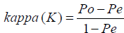
Where:
Po = is the proportion of correctly classified classes Pe = is the proportion of correctly classified values expected by chance
The user’s accuracy or reliability is the probability that a pixel classified on the map actually represent that category on the ground. User’s accuracy is when the total number of correct pixels in a category divided by the total number of pixels that were actually classified in the category (row total); the result is a measure of commission error. The accuracy assessment checked for satellite image classification has presented in Table 3 as follows. As indicated in the above, confusion matrix was used to show the classification accuracy of the two satellite images. Overall accuracy can be obtained by dividing the total number of correct pixels (diagonal) by the total number of pixels in the error matrix [1]. The overall accuracy of image classification has showed a very good classification accuracy with overall accuracy and kappa coefficient value of 0.84 and 0.8 respectively. This indicated that the method of classification and the ground control (truth) points collected and used were very successful.
Land use change detection
The upper Ri bb watershed is characterized by high cultivation along the valleys of the main river and the tributaries. The agriculture/ cultivated land is dominant land cover in the watershed. The main land use/cover types detected in upper Rib watershed are forest, Urban, Agriculture, Bare Land, Grass Land and water body. Satellite image of 2007 indicated that; agriculture, grassland and forest cover about 72.156%, 23.56% and 3.89% of the watershed respectively. Similarly, in 2018, agriculture land showed high coverage with 85.94 percentage followed by grassland with a total coverage of 7.59%. As shown in Table 2, the major types of land cover showed in both of the years is agriculture followed by grassland and forest. The change in land use/cover has detected in all over 11 years period. The classification has indicated that there is an increase of agricultural land by 13.78% which is caused due to an increase in population. The increase in population has resulted in increase in interest to crop production which leads the conversion of grasslands to croplands. The forest cover has increased by 1.46% due to millennium development afforestation programs implemented in the watershed. The water coverage also increased by 0.7% due to the construction of Rib reservoir. On the other hand, grassland had been decreased by 15.97%; which is changed to an intensification of agricultural land. Similar studies in some other parts of the country has showed a comparable result to this study findings. Mengistu [26] found out; forest and grasslands were changed to farmlands and settlements, woodlands and bush land were altered to grasslands, but at a decreasing rate when compared to the case of forest conversion to farmland and settlements. According to Dires, during the 35-year period (from 1972 to 2007), the proportion of bushland trebled, while the area of cultivated land increased eightfold. Jemberie et al. [27] had presented also similar results, during 25-year period (from 1986 to 2010) the cultivated land increases at about 12% whereas the forested area decreased by 3.61%. Andualem and Gebremariam [1] has found also a similar result in Gilgel Abbay Watershed, he stated that the cultivated land cover shows a dramatic increase during the first period (1986 – 2000) with +24.12% than the second period (2000 – 2011) with +9.67%, on the other hand shrub lands, water and forest showed a significant decrease in the first period. On the contrary grasslands showed a higher decrease during the second period (-14.39%) than the first period (-10.01%). He finally concluded that the changes in one land use cover resulted in a change in on the other land cover types.
Conclusion
Remote sensing technology is the widely applied technology used for land use change detection analysis. The land use land cover change detection for Rib watershed had been done from satellite images downloaded and classified using ERDAS Imagine software. The results of the study indicated that there was a dramatic land use land cover change over 11 years period of time in Upper Rib watershed. There was an increase of agricultural land by 13.78%, and a decrease of grass land by 15.97% from 2007 to 2018. The grassland was basically changed to agricultural land due to an increase of population growth leads to high demand for cropland in the area. This was related to the continued expansion of cultivated and settlement over years in Ribb River watershed. The knowledge about the change in land use is so essential for the administration and land use planning activities in upper Rib watershed. This is so for, the increase and productivity of Rib reservoir by reducing the upland erosion through effective land use planning and soil conservation practices. Hence, this study revealed that there is an increase of agricultural land which needs due attention towards soil conservation for the enhancement of the useful life of the reservoir.
Conflict of Interest
There is no conflict of interest between authors.
References
- Andualem TG, Gebremariam B (2015) Impact of land use land cover change on stream flow and sediment yield: A case study of Gilgel Abay watershed, Lake Tana Sub-Basin, Ethiopia. Int J Technol Enhance 3: 28-42.
- Getachew HE, Melesse AM (2012) The impact of land use change on the hydrology of the Angereb Watershed, Ethiopia. Water Sci Technol pp:1-2.
- Verity GE, Anderson DW (1990) Soil erosion effects on soil quality and yield. Can J Soil Sci 70: 471-484.
- Batisani N, Yarnal B (2009) Urban expansion in Centre County, Pennsylvania: Spatial dynamics and landscape transformations. Appl Geogr 29: 235-249.
- Prakasam C (2010) Land use and land cover change detection through remote sensing approach: A case study of Kodaikanal Taluk, Tamil nadu, India. International Journal of Geomatics And Geosciences 1: 150.
- Minale AS, Rao KK (2011) Hydrological dynamics and human impact on ecosystems of Lake Tana, northwestern Ethiopia. Afr J Environ 4: 2.
- Shiferaw A, Singh KL (2011) Evaluating the land use and land cover dynamics in Borena Woreda South Wollo Highlands, Ethiopia. Ethiop J Bus Econ 2: 1.
- Sarma VVLN, Murali Krishna G, Hema Malini B, Nageswara Rao K (2001) Landuse/landcover change detection through remote sensing and its climatic implications in the Godavari Delta Region. J Indian Soc Remote 29: 85-91.
- Pandian M, Rajagopal N, Sakthivel G, Amrutha DE (2014) Land use and land cover change detection using remote sensing and GIS in parts of Coimbatore and Tiruppur districts, Tamil Nadu, India. J Indian Soc Remote 3: 1.
- Singh A (1989) Review article digital change detection techniques using remotely-sensed data. J Indian Soc Remote 10: 989-1003.
- Imbernon, J (1999) Pattern and development of land-use changes in the Kenyan highlands since the 1950s. Agriculture, Ecosystems & Environment 76: 67-73.
- Adamo SB, Crews-Meyer KA (2006) Aridity and desertification: exploring environmental hazards in Jáchal, Argentina. ‎Appl Geogr 26: 61-85.
- Shalaby A, Tateishi R (2007) Remote sensing and GIS for mapping and monitoring land cover and land-use changes in the Northwestern coastal zone of Egypt. Appl Geogr 27: 28-41.
- Batisani N, Yarnal B (2009) Urban expansion in Centre County, Pennsylvania: Spatial dynamics and landscape transformations. Appl Geogr 29: 235-249.
- Dewan AM, Yamaguchi Y (2009) Land use and land cover change in Greater Dhaka, Bangladesh: Using remote sensing to promote sustainable urbanization. Appl Geogr 29: 390-401.
- Wyman MS, Stein TV (2010) Modeling social and land-use/land-cover change data to assess drivers of smallholder deforestation in Belize. Appl Geogr 30: 329-342.
- Mouflis GD, Gitas IZ, Iliadou S, Mitri GH (2008) Assessment of the visual impact of marble quarry expansion (1984–2000) on the landscape of Thasos island, NE Greece. Landsc Urban Plan 86: 92-102.
- Munroe DK, Croissant C, York AM (2005) Land use policy and landscape fragmentation in an urbanizing region: Assessing the impact of zoning. Appl. Geogr 25: 121-141.
- Lambin EF, Geist HJ, Lepers E (2003) Dynamics of land-use and land-cover change in tropical regions. Annual review of environment and resources 28: 205-241.
- Sage C (1994) Population and income. In: Meyer W.B. and Turner B.L. (Eds) Change in land use and land cover. A global perspective. Cambridge University Press, Cambridge, UK. pp: 263-285.
- Meyer WB, Turner BL (1994) Changes in land use and land cover: A global perspective. Cambridge University Press, UK. p: 4.
- Coppin P, Jonckheere I, Nackaerts K, Muys B, Lambin E (2004) Digital change detection methods in ecosystem monitoring: A review. Int J Remote Sens 25: 1565-1596.
- Eastman RJ (2006) IDRISI Andes: Guide to GIS and image processing. Worcester, MA: Clark Labs, Clark University, USA.
- Lillesand TM, Kiefer RW (1994) Remote sensing and image interpretation (4th edn) New York: Wiley, USA. 132: 248.
- Owojori A, Xie H (2005) Landsat image-based LULC changes of San Antonio, Texas using advanced atmospheric correction and object-oriented image analysis approaches. In 5th International symposium on remote sensing of urban areas, Tempe, AZ, USA.
- Mengistu KT (2009) Watershed hydrological responses to changes in land use and land cover, and management practices at Hare Watershed, Ethiopia.
- Jemberie M, Gebrie T, Gebremariam B (2016) Evaluation of land use land cover change on stream flow: a case study of Dedissa sub basin, Abay basin, South Western Ethiopia. Evaluation IJIERT 3: 44-60.
Citation: Andualem TG, Belay G, Guadie A (2018) Land Use Change Detection Using Remote Sensing Technology. J Earth Sci Clim Change 9: 496. DOI: 10.4172/2157-7617.1000496
Copyright: © 2018 Andualem TG, et al. This is an open-access article distributed under the terms of the Creative Commons Attribution License, which permits unrestricted use, distribution, and reproduction in any medium, provided the original author and source are credited.
Select your language of interest to view the total content in your interested language
Share This Article
Recommended Journals
Open Access Journals
Article Tools
Article Usage
- Total views: 9100
- [From(publication date): 0-2018 - Dec 06, 2025]
- Breakdown by view type
- HTML page views: 7797
- PDF downloads: 1303