Locational Analysis of Hill Cutting Areas in Chittagong city, Bangladesh
Received: 14-Aug-2017 / Accepted Date: 03-Nov-2017 / Published Date: 08-Nov-2017 DOI: 10.4172/2157-7617.1000420
Abstract
Hills, rivers, lakes and adjacent the Bay of Bengal are the main indicators of beauty in Chittagong city. Currently indiscriminate hill cutting is considered as one of the major environmental destructions in Chittagong city. Hill cutting problems are triggering deforestation and loss of biodiversity, local level climate change, increasing water logging and landslides. Remarkably, few researches are available to help identifying geographical distribution of hill cutting areas in Chittagong city, Bangladesh. This paper addresses this gap by conducting field investigations, observations and surveys in Chittagong city Corporation (CCC), Bangladesh. Through field investigations, observations and surveys, this research divides hilly areas in four categories. These include a) existing hilly areas, b) moderately susceptible hilly areas, c) highly susceptible hilly areas, and d) extinct hilly areas. The research suggests that there are still 40 hills in CCC which still are not affected by any hill cutting problems. The moderately susceptible hilly areas are located in Khulsi and Bayazid Bostami thanas. The highly susceptible hilly areas are located in Bayazid Bostami (11 Hills), Khulshi (10 Hills) and Kotowali thanas. The extinct hilly areas are mainly located in Panchlaish, Bayazid, Kotowali and Khulshi thanas. In order to stop hill cutting in Chittagong city, this research suggests six key areas of actions: (i) education and training, (ii) information collection and dissemination, (iii) formation of strong advisory committee, (iv) enforcement of laws by consisting of personnel from Bangladesh Army, Police, Ansar and BDP, (v) monitoring hilly areas by LiDAR DEM and (vi) formation of a monitoring committee to report strength and weakness of hill protection activities time to time.
Keywords: Geography; Hill cutting; Problem; Susceptible; Environment
Introduction
Chittagong city is vulnerable to a variety of natural and human induced hazards including tropical cyclones, earthquakes, tsunamis, floods, landslides, and water logging due to its geographical location. Many physical environmental parameters such as hills, rivers, ocean and lake make the city of Chittagong a beautiful one in the world. In the last one and half decades, the city experiences significant increase in landslide activity. A variety of natural and human induced reasons has contributed to accelerating landslide events in the recent past. These include: excessive and prolong rainfall in a short period; unplanned hill cutting problems; loose soil structure in hilly areas; deforestation in the hilly areas; seismic activity and abnormal tidal flow [1-3]. Due to the presence of excessive formal and informal settlement (Figure 1) along the foothills have increased vulnerability to landslide events. Hill cutting areas have been using both for formal and informal settlement development [4].
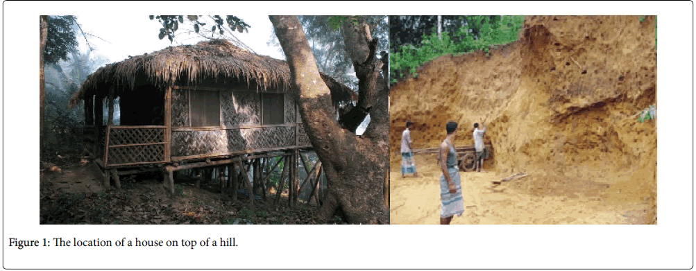
Figure 1: The location of a house on top of a hill.
There were over 200 hills in Chittagong city in early 1910. During British colonial period, the central British government planned to set up their main administrative buildings on top of the hills considering the safety of their local administrators. For an example, the Judge Court building of Chittagong city was built on the top of Parir hill by the British government. Subsequently, many other administrative, college, and public buildings were established at that time. Following independence of Bangladesh in 1971, the commercial and business importance of the city had increased markedly. Human population of the city was also doubled in 1980. Due to both rises in human population and increases in commercial and business activity necessitated further new land development in the Chittagong city. From early 1980, there was a trend in hill cutting to accommodate excessive land demand. Since late 1990, the problem of hill cutting attracted much print media coverage due to decrease in wetland in and around Chittagong city, increase in water logging problem and landslide occurrences.
An increasing amount of research from local, regional and international institutions documented hill cutting problems and subsequent landslide occurrences in Chittagong city [5-10]. Islam et al. suggested that slope failure hazards are occurring every year due to heavy rainfall in loose soil structure in the hill cutting areas in Chittagong city. Landslide took over 400 deaths mostly in informal settlement in Chittagong city since 2000. The 2007 landslide event took 127 deaths in informal settlement. Although the government of Bangladesh identifies these informal settlers are illegal occupants, the settlers trust that they are the legal owners of these areas. This makes complexity in reducing vulnerability of informal settlers to landslides [11]. Although numerous studies were undertaken to record and analyze landslide occurrences in hill cutting areas, no systematic effort was carried out to identify current hilly areas and hill cutting areas in Chittagong city. This paper addresses this gap by conducting field investigations, observations and surveys in Chittagong city Corporation (CCC), Bangladesh. The main aim of the research is to identify hill cutting areas in Chittagong city. The specific objectives of this research are to:
1. Identify geographical distribution of existing hilly areas, hill cutting areas and extinct hilly areas in Chittagong city.
2. Identify risk management strategies relating to hill cutting in Chittagong city.
In the following sections, at first, I introduce the location of Chittagong city in Bangladesh. This is followed by methods used for this research. In the subsequent sections, I present results of this paper. Finally, I provide conclusion and make a series of recommendations for implementing risk reduction strategies.
Materials and Methods
Location of study area
The Chittagong city (Figure 2) is located in southeast of Bangladesh between 21°54ʹ N to 22°59ʹ N latitude and 91°7ʹ E to 92°14ʹ E longitude. Geologically, Chittagong occupies a part of the Western margin of Tripura-Chittagong folded belt. This folded belt is directed in the NNW-SSE direction and these folds are frequently faulted longitudinally and transversely to the strike [12]. Chittagong is located within the Tertiary hill region of folded flank of Bengal fore deep. The folded part is composed of the Tipam sandstone formation and Girujan clay formation of Pliocene age at the bottom and Dupi Tila formation of Plio-Pleistocene age at the top [13]. The city comprises of the area of small hills and narrow valleys, lakes, rivers and flood plains. It is encircled by Karnaphuli river in its eastern and southern parts. The Bay of Bengal and narrow coastal plain are located to the west and the floodplain of Halda river on the east and south. The highest elevation of the hill in the city is approximately 60 m above mean sea level [14].
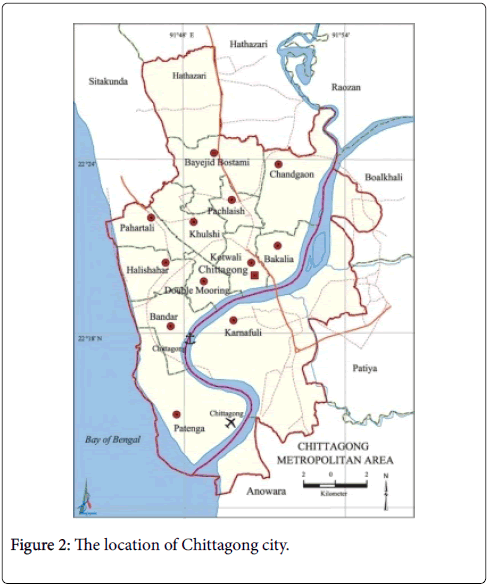
Figure 2: The location of Chittagong city.
Data collection
This research was conducted within the boundary of Chittagong city Corporation (CCC). Hill cutting areas in Chittagong city was identified based on field visits, investigations, field surveys and observations. Field research of this paper was completed during January-2015 to June-2015 with the help of eight efficient data collectors. This research divides hill cutting areas into three categories based on the extent of the problem. These include moderately susceptible, highly susceptible, and extinct hilly areas. When any part of a hill is cut down, it is defined as moderately susceptible hill. If more than half of a hill is cut down, it is defined as highly susceptible hill. Where there was a hill once upon a time is defined as extinct hilly area. The name of hill is presented by local popular name of hill. Geographic Information Systems (GIS) and cartographic techniques were used to represent the existing location of hilly areas, hill cutting areas and extinct hilly areas. Secondary data sources such as research reports, peer review publications, daily newspapers about hill cutting problem were used to write up the research paper.
Results and Discussion
Existing hilly areas in Chittagong city
Although the Chittagong city lost over 120 hills in the past forty years, field survey suggests that over forty hills were remained unaffected in Chittagong city (Table 1). Currently most of the hills are located in the Bayezid Bostami, Cantonment, Panchlaish, and Khulshi thanas of Chittagong city (Figure 3). Despite reckless hill cutting problem in the other part of the City, these hills were unaffected due to six reasons: some of these hilly areas are located in protected part of the Cantonment thana; inaccessibility to these hilly areas obstructs setting up brick kilns, residential apartments, and other development activities; distance from the center of the City; high slope of these hills; recent strong law enforcement.
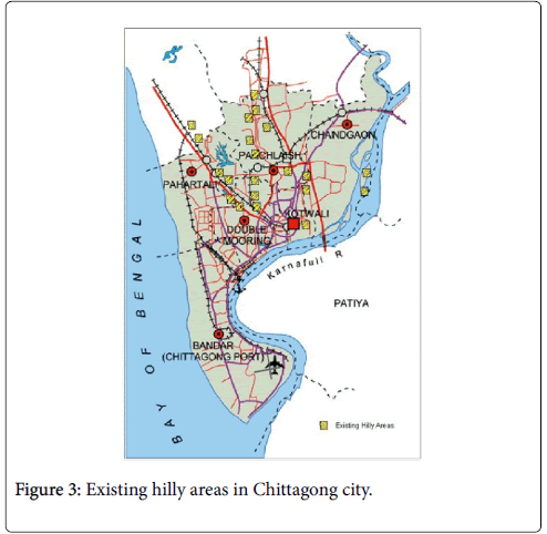
Figure 3: Existing hilly areas in Chittagong city.
| Location of hill and hilly areas | Name of CCC Word | Thana | Identification of hill by popular name | Existing establishment |
|---|---|---|---|---|
| Fer School Pahar | 02 Zalalabad | Bayezid | West of Burma Colony | - |
| Kalapenia, Chakter, Betua, Bazan, Mezbanna, Eckandia and Harina Pahar | 01 South Pahartali | Bayezid | Batali Colony | Few settlement |
| Shipping Corporation Pahar | 09 North Pahartali | Khulshi | East Peroj Shah | Temple and settlement |
| Goal Pahar, Pravartak pahar | 15 Baghmoniram |
Panchlaish | Intersection of O.R. NizamRoad and Panchaish Thana | - |
| Chairman Bunglow Pahar (Residence of SP) |
15 Bugmony village | Khulshi | C.R.B Railway Colony |
Houses of railway staff |
| Railway Pahar | 15 Bugmony village | C.R.B Railway | C.R.B Railway | Railway establishment |
| Zilapi Pahar (Chotto Batali Pahar) | 14 Lalkhan Bazar | Khulshi | Moti Jhorna Road | - |
| Tunky Pahar | 14 Lalkhan Bazar | Khulshi | Moti Jhorna Road | Few settlement |
| 31 Field Ambulance Zone Pahar | 01 South Pahartali | Bayezid | Zalalabad Road | Military establishment |
| Dula Mura Pahar | 01 South Pahartali | Bayezid | Beside Oxygen | Electric Pillar |
| Kuri, Baighna, Adar Zora, Putu Zora, Hulod Barna, Shira, Harina Chara, Artika, Munchi Dala and Kantor Ali Pahar | 01 South Pahartali | Bayezid | Military Check post, fifth Gate, Borodigir Par, Cantonment | - |
| Joi Pahar | 16 Chawkbazar | Panchlaish | Intersection of Chatteswari road, Surson road and Jamal Khan Mure | - |
| DC Hill | Jamal Khan | Kotawali | Near Buddhist temple | Residence of Deputy Commissioner |
| Bangladesh Bank Pahar | 15 Baghmoniram |
Panchlaish | West of Mimi super market | - |
| CDA Hill | 15 Baghmoniram |
Panchlaish | Besides Mehidibag housing | - |
Source: Field survey, 2015.
Table 1: Existing hilly areas in Chittagong city.
Moderately susceptible hilly areas
In this research, moderately susceptible hilly areas are defined those hilly areas have already been partly cut down or currently hill cutting is occurring. Approximately eight hills in Khulshi thana can be defined as moderately susceptible condition. Some luxurious apartment complex is going to be developed by cutting existing hilly areas. Groups of poor people also cut some part of hills and make slumsettlement beside these hills. Subsequently these foothill settlements are very susceptible to landslides. For an example, during 2002 about four people died in the Batali hill area by landslides. Poor people cut some part of hills and developed slum settlement in the foothill of the Moti Jharna Road Pahar, Tunky Pahar, Bisha Colony, Balu Pahar, etc. Moderately susceptible hill cutting areas are mainly located in Bayezid and Khulshi thanas (Table 2) (Figure 4). Five brick kilns are set up in these areas, which are using hill cutting soil as raw materials. Soil erosion is another common problem in these partly hill cutting areas. Those hills located beside the Garibullah Shah Mazar are an example of partly hill cutting area and the erosion of the hill is creating water logging in the adjacent areas.
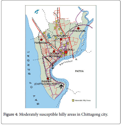
Figure 4: Moderately susceptible hilly areas in Chittagong city.
| Name of Hill | Word No | Thana | Identification | Existing establishment |
|---|---|---|---|---|
| Glasxo Pahar | 13 Pahartali | Khulshi | Road No 1, Lane 2 Block A, South Khulshi |
Luxurious building |
| Ispahani Pahar | 13 Pahartali | Khulshi | 300 Feet West of GEC | Nasirabad Housing Society |
| Balur Pahar | 9 North Pahartali | Khulshi | Bisha Colony | Slum |
| Ispahani Gate Pahar | 9 North Pahartali | Khulshi | Beside Panjabi Graveyard | Graveyard |
| Akbar Shah Mazar Pahar | 9 North Pahartali | Khulshi | Akbar Shah Graveyard Road | Mazar Building |
| Tiltali Pahar | 9 North Pahartali | Khulshi | East side of Foy’s Lake | C.I. Sheet Housing |
| Abangali Pahar | 14 Lalkhan Bazar | Khulshi | Motijarna Road West of Batali Hill |
Slum |
| Batali Hill | 14 Lalkhan Bazar | Khulshi | Beside Tiger Pass | Defence building and Tower Building |
| Nacini Khola Pahar | 1 South Pahartali | Bayazid | No.1 South Jungle Pahartali |
Low income Residence |
| Signal Battalion Pahar | 1 South Pahartali | Bayazid | Jalalabad (Beside Oxyzen) | Military Establishment |
| Kata Pahar and Rasheed Saheber Pahar | 1 South Pahartali | Bayazid | Cantonment checking post (No 4) | - |
| Nanda Gora, Korwainna Pahar | 1 South Pahartali | Bayazid | Sekandor Colony, opposite to Military check post |
Scattered Settlement |
Source: Field Survey, 2015
Table 2: Moderately susceptible hilly areas in Chittagong city.
Highly susceptible hilly areas
Some hilly areas are highly susceptible condition. Field visits and investigations suggest that currently in CCC approximately 25 hills are in highly susceptible condition (Table 3). Over half of these hills have already been cut down. Soils obtained from these hills are using as raw materials of brick kiln and filling up low-land areas for residential or commercial building construction purposes. Similarly, hill cutting areas are mainly using for apartment development purpose. The highly susceptible hill cutting areas are located in Bayazid Bostami (11 Hills), South Khulshi (10 Hills) and Kotowali thanas (5 hills). Highly susceptible hilly areas in Chittagong city are presented in Figure 5. Local residents reported that hill cutters somehow manage local administration and political leaders for their purpose. During field investigation it is observed that brick kiln and hill cutting are closely located in the highly susceptible hilly areas. Local residents adjacent to brick kilns complain that smoke and wastage of kiln are causing diseases. Besides, due to hill cutting problem, a number of slum dwellers lost their settlement. Forest and animals of the hilly area are gradually disappearing.
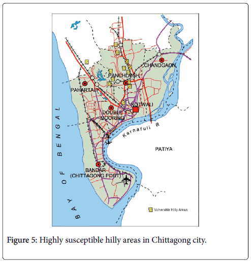
Figure 5: Highly susceptible hilly areas in Chittagong city.
| Name of Hill | Word No. | Thana | Identification of hill | Existing establishment |
|---|---|---|---|---|
| Hatir Pahar | 07 Bubabad | Bayazid | Bangladesh cooperative housing society (east of KDS Garment) | Location for dumping CCC wastage |
| Chera Pakirer Pahar | 07 Rubabad | Bayazid | Bangladesh cooperative housing society (east of KDS Garment) |
Bangladesh cooperative housing society |
| Miar Pahar | 07 Rubabad | Bayazid | Bangladesh Cooperative Housing Society (east of KDS Garment | West part of KDS Garments |
| Jalalabad Housing Society Pahar | 13 East Pahartali | South Khulshi | Beside Veterinary College | Jalalabad cooperative housing society |
| A K Khan Pahar | 13 East Pahartali | South Khulshi | South Khulshi | Luxurious apartment complex |
| Shahi Nagar Pahar | 10 Jalalabad | South Khulshi | Back side of Bangladesh Tea Board | Asian University for Women |
| CDA Hill | 15 Bagmoniram | Panchlaish | Some Part of Mehadibag Road | New residential buildings |
| Chanmari Pahar | 14 Lalkhan Bazar |
South Khulshi | Beside Izharul Estate Pahar | - |
| Shahajan Shaheber Barir Pahar | 14 Lalkhan Bazar |
South Khulshi | Mati Jharna Road | Low income houses |
| Ohabi Pahar | 14 Lalkhan Bazar |
South Khulshi | Garibullah Housing Society | - |
| Shadur Pahar | 1 South Pahartali | Bayazid Bostami | South of Sandwip Colony | Brick kiln |
| Ball khela Paharer Math | 1 South Pahartali | Bayazid Bostami | Middle of Hatiya-Sandwip Colony | - |
| Dev Pahar | 16 Chawkbazar | Panchlaish | Beside Government Hazi M. Mohsin College | New residential building and slum area |
Source: Field Survey, 2015
Table 3: Highly susceptible hilly areas in Chittagong city.
Extinct hilly areas in Chittagong city
Hilly areas in Chittagong city have been facing indiscriminate cutting and unauthorized occupancy problems since 1971. Topography of Chittagong city has changed markedly due to the loss of the hills by cutting problem. The hill cutting areas are now being used for residential and commercial purposes. For example, Taz Company Building at Chawkbazar and Jalalabad Housing Society at Jalalabad area. From their current usage, it could be very hard to guess that once there were hills in these areas. Most of the extinct hill cutting areas are located in Panchlaish, Bayazid, Kotowali and Khulshi thanas (Table 4). In last two decades, hill cutting areas are mainly being used for settlement purpose. On few occasions, brick kilns are set up in hill cutting areas.
| Name of hill | Ward No | Thana | Identification of hill | Existing establishment |
|---|---|---|---|---|
| Medical Pahar (Trunky Pahar) | 16 Chawkbazar | Panchlaish | Chattreschari Road, South of Medical College | Building of Taz Company |
| Finley Company Pahar | 16 Chawkbazar | Panchlaish | Chattreschari Road | Building of Taz Company |
| Hashem Corporation and Taz Company Pahar | 16 Chawkbazar | Panchlaish | West of Medical College | Control under Taz Company |
| Jalalabad Housing Society Pahar | 13 Pahartali | Khulshi | Murghi farm road South Khulshi |
Brick Klin and Housing Society |
| Bhera Fakir Pahar | 07 Rubabad | Bayazid | Bangladesh Cooperative Housing Society beside KDS | Madrasha and Housing Society |
| Shahinagar Pahar | 10 Jalalabad | Bayazid | Dhaka-Ctg. Trunk Road, Bayazid link Road | New buildings for Asian University for Women |
| Hatir Pahar | 07 Robabad | Bayazid | Bangladesh Cooperative Housing Society Road | New houses construction |
| A.K. Khan Pahar | 13 Pahartali | Khulshi | Road No.1 South Khulshi | VIP Housing Society |
| Ispahani Pahar (West and South-East Part) | 13 Pahartali | Khulshi | Child Heaven School l Road, South Khulshi | Tower Building |
| Ball Khelar Math Pahar | 01. South Pahartali | Bayazid | Sandwip Colony Chowdhury hat road |
Brick Kiln |
| Sona Gazi Pahar | 01. South Pahartali | Bayazid | Beside Nandir Hat | Brick Kiln |
| Dreamland Pahar | 10. Jalalabad | Bayazid | Beside Burma Colony | Dreamland Housing Project |
| CDA Hill | 16 Mehedibag | Panchlaish | Mehedibag Road | Amirbag Housing Society |
| Cheragi Pahar | Jamal Khan | Kotowali | Jamal Khan Road | Building by filling up Razar Pukur |
| Goal Pahar | Sulukbahar | Kotowali | Building |
Source: Field Survey, 2015.
Table 4: Extinct hilly areas in Chittagong city.
Conclusion and Recommendation
Chittagong city has been facing uncontrollable hill cutting problem in the last four decades. The problem has been accelerated since early nineteen nineties. It is widely believed that hill cutting problem in the Chittagong city are triggering some major environmental and social problems. The includes landslide hazards and associate deaths, high flooding and prolong drainage problem in rainy season, decreasing ponds and marshy areas, hill slope failure and erosion, decreasing biodiversity, accelerating earthquake associated risk, desertification and deforestation. Islam et al. showed that most of the dry slopes may fail at medium to large earthquakes. By using community vulnerability assessment tool (CVAT), Das and Raja [15] suggested that built environmental infrastructure (i.e. roads, residential buildings and etc.) and human population are highly susceptible to landslide occurred in Chittagong city. Over fifty percent hills of the City have been lost due to hill cutting habituate. The Soils of the hill cutting areas are using for the raw materials of brick kiln and filling up of marshy areas. Hill cutting areas are using for settlement and commercial purposes. The field survey suggests that hilly areas in the heart of the city are at high risk.
The environmental management authority in Chittagong city should develop current topographic map by using 5-meter contour data, high resolution LiDAR DEM for proper city planning purpose. Natural Park and forest management people need to use High Resolution LiDAR DEM. LiDAR data are widely used for resource management, urban planning, transportation planning, natural park management, habitat mapping and environmental assessments. LiDAR can extract various feature information, including building footprints, trees and forests. GIS based aerial photograph overlay technique can help to detect new hill cutting areas. This can provide data where we need to take urgent action to stop ongoing hill cutting problem. On occasions, open source GIS can help for data collection from the United States Geological Survey (USGS) and lots of free open source GIS software available for new users.
The findings of field survey and review of existing hill cutting stopping actions and practices, suggest that five programs of action can be undertaken in Chittagong city. First, this research suggests strengthening ongoing awareness, education and training for general people. All level education curriculum should Include relevant environmental education and training. Second, it recommends setting up an information center to protect hilly areas. There should have scope to disseminate information to newspapers, radio, television channel and social media. Third, formation of a strong advisory committee that comprise of environmentalist, journalist, local hill loving people, mainstream political parties and representative from civil and defense administration. Fourth, the formation of a new enforcement personnel consisting of Bangladesh Army from Chittagong Cantonment and Bangladesh Military Academy), Bangladesh Police, Ansar and BDP. Fifth, formation and activation of a monitoring committee to report strength and weakness of hill protection activities from time to time.
References
- Ahmed B, Rahman MS, Rahman S, Huq FF, Ara S (2016) Landslide inventory report of Chittagong Metropolitan Area, Bangladesh.
- Chisty KU (2014) Landslide in Chittagong city: A perspective on hill cutting. J Bangladesh Institute of Planners 7: 1-17.
- Sarwar GM (2008) Landslide tragedy of Bangladesh. The First World Landslide Forum, 18-21 November 2008, United Nations University (UNU), Tokyo, Japan.
- Alam E, Chowdhury MA, Akbar MT (2005) Aspects of socio-environmental problems resulting from hill cutting in Chittagong city of Bangladesh: local people’s perspectives. The Pakistan Journal of Social Science 3: 1048-1052.
- Hassan MM, Ahmed S, Patwary NH, Yeasmin L, Shahidullah SM, et al. (2015) Environmental degradation through hill cutting in Chittagong district of Bangladesh. Int J Nat Soc Sci 2: 41-54.
- Islam MS, Hosain M, Islam MS, Ahmed AS, Hoque F, et al. (2015) Disaster due to slope failure in the Pahartoli area of the Chittagong city, Bangladesh. Int J Sci Engineer Res 6: 246-251.
- Islam MS, Islam MS, Ahmed AS, Karim SU, Hosain M, et al. (2015) Seismic induced landslide vulnerability in the Chittagong city, Bangladesh. J Geotech Engineer 2: 1-13.
- Mahmood AB, Khan MH (2010) Landslide vulnerability of Bangladesh hills and sustainable management options: A case study of 2007 landslide in Chittagong city. SAARC workshop on landslide risk management in South Asia, 10-12 May, 2010, Thimpu, Bhutan.
- Mia MT, Sultana N, Paul A (2015) Studies on the causes, impacts and mitigation strategies of landslide in Chittagong city, Bangladesh. J Environ Sci Nat Res 8: 1-5.
- Murshed MM (2013) Cutting of hills and human tragedy: An example of law enforcement loophole in the southeastern region of Bangladesh. Int J Geomat Geosci 4.
- Ahammad R (2009) Understanding institional changes for reducing vulnerability to landslides in Chittagong city, Bangladesh. Master thesis, Stockholm Resilience Centre, Stockholm University, Sweden.
- Matin MA, Khan MA, Fariduddin M (1983) The tectonic map of Bangladesh-past and present. Bangladesh J Geol 2: 29-36.
- Khan YA, Chang C (2008) Landslide hazard mapping of Chittagong city area, Bangladesh. Indian Soc Eng Geol 35: 303-311.
- Khan YA, Lateh H, Baten MA (2012) Critical antecedent rainfall conditions for shallow landslides in Chittagong city of Bangladesh. Env Earth Sci 67: 97-106.
- Das S, Raja DR (2015) Susceptibility analysis of landslide in Chittagong city Corporation area, Bangladesh. Int J Environ 4: 157-181.
Citation: Alam E (2017) Locational Analysis of Hill Cutting Areas in Chittagong city, Bangladesh. J Earth Sci Clim Change 8: 420. DOI: 10.4172/2157-7617.1000420
Copyright: © 2017 Alam E. This is an open-access article distributed under the terms of the Creative Commons Attribution License, which permits unrestricted use, distribution, and reproduction in any medium, provided the original author and source are credited.
Select your language of interest to view the total content in your interested language
Share This Article
Recommended Journals
Open Access Journals
Article Tools
Article Usage
- Total views: 14356
- [From(publication date): 0-2017 - Aug 02, 2025]
- Breakdown by view type
- HTML page views: 13316
- PDF downloads: 1040