Medium-term Erosion Processes of South Adriatic Beaches (Apulia, Italy):A Challenge for an Integrated Coastal Zone Management
Received: 21-Sep-2015 / Accepted Date: 26-Oct-2015 / Published Date: 06-Nov-2015 DOI: 10.4172/2157-7617.1000306
Abstract
This paper aims to evaluate the causes of shoreline shift on a low-lying coast whose beaches have undergone erosion throughout the last six decades. The case study regards about 70 km long southern Adriatic coast of Apulia (Italy). Shoreline retreat has affected the economy of the tourism activities as well as forced environmental changes in lagoons and coastal moist areas. The study was carried out using field surveys and interpretation of map, orthophots and satellite images. Shoreline mobility changes in space and in time are stressed. Mean shoreline retreats of 10 (±5) m from the late 1940s to the late 1980s, and of 5 (±2.5) m from the late 1980s to the early 2010s have been estimated. Retreats up to 50 (±10) m have affected portions of beach of tens of meters long and particularly prone to erosion. A pocket beach was in dynamic equilibrium over the last twenty years and most likely progradated over the last six decades. The collected data allow for the determination of changes in the possible main cause of erosion occurred in the early 1990s. In view of climatic changes, the economic relevance of the coast for the tourism industry, the importance of several habitats and the uncertainty about the magnitude of erosion processes make the development of tools for the integrated management of the coastal zone an engaging challenge.
Keywords: Coastal erosion, Environmental changes; Sea level rise; Uncertainty; Urban sprawling
9022Introduction
Since the 1980s, erosion is widely considered the main process acting on the coasts of the Earth [1]. Due to the concern for the consequences of the Sea Level Rise (SLR), it quickly became an "escalating environmental threat" [2]. Meanwhile, public alarm rose about the inundation risk of coastal plains. Later the problem of loss of the beaches grew to be a huge economic damage for the tourism industry [3]. Low-lying coasts are particularly prone to suffer such negative consequences. Despite of a large part of researchers consider SLR the driving phenomenon of the erosion process [4,5], other causes may contribute at the local scale. Among the latter, increases in storm surges and human interferences are frequently stressed in mediumterm (some decades) assessments, sometimes as the main cause of beach erosion.
The amount of shoreline retreat for a given coast is frequently evaluated in different manners according to both the researchers and the methods. This is the case of the about 300 km long beaches of the Apulia region (South Italy). According to the Atlas of the Italian Beaches of the National Research Council [6] the 30% of the beaches of Apulia showed retro gradation, only the 0.3% (i.e. 1 km) progradation and the 70% was in equilibrium. Different estimate of the sedimentary processes is documented in the Plan of the regional authority for the coastal management that is in turn based on a GIS (Geographical Information System) study of the governmental Agency for Environment Protection and Technical Service. The plan stated that the regional beaches in accretion (22.6%) exceed those in retreat (21.4%). The uncertainty about the actual general trend of the sedimentary dynamics is evident. It must be noted that the CNR atlas [6] is the product of a field-oriented research, whereas the GIS study of the governmental Agency is based on coastline extraction from orthophotos. The inconsistency between the two statements of the coastal processes denotes the need to integrate the field surveys with the interpretations of aerial and satellite images, as is here proposed. This paper aims to evaluate the causes of medium-term (about sixty years) shoreline shift of the gently sloping southern Adriatic coast of Apulia. The geographical location of the studied area coincides with the northeastern coast of the Salento peninsula (Figure 1). It represents an example of Mediterranean coast with different human activities and some important areas of environmental interest. The final goal is to give some insight for suitable Integrated Coastal Zone Management (ICZM).
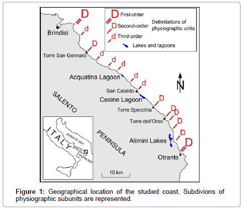
Figure 1: Geographical location of the studied coast. Subdivions of physiographic subunits are represented.
Case Study
The first research that stated enhanced erosion for the beaches of Apulia dates back to the 1980s [7]. According to this study, the erosion processes have acted since at least the 1950s. Further studies have confirmed such a sedimentary trend [8]. To face this issue, the aforementioned regional plan for the coastal management identifies seven main (first-order) physiographic units. The about 70 km long coast here considered coincides with the unit delimited by two main promontories that extends from east of Brindisi to north of Otranto (Figure 1). Bedrock is made by Tertiary and Quaternary calcareous formations and is characterized by karst forms and sinkhole phenomena [9]. It frequently outcrops along foreshore and upper shore face, thus making beaches particularly prone to erosion [10]. The studied coast is subdivided into a number of physiographic subunits by headlands and coastal defence constructions. Sand of the Apulian beaches come from three sources. Rivers that flow north and central side of the region supply the beaches of siliciclastic terrigenous sediments. Carbonates factories in shallow marine water produce biogenic detritus. Finally, dismantling of rocky cliffs nourishes beaches for a reduced amount [11]. Siliciclastic grain-size ranges from fine to very fine for the northeastern Adriatic beaches of the Salento peninsula. The average grain-size of the biodetritic component becomes larger south-eastward changing from medium to coarse sand [10]. According to the dominant wind direction [12], on decennial time scale, prevailing longshore sand transport is directed from NW to SE. A few years, episodic prevalence of wind from SE may reverse the direction of longshore drifting. Maximum tidal occurs at about 0.4 m, while its mean value does not exceed 0.2 m. Wavelengths indicate a maximum wave-base level of 20-25 m in depth [11]. Several dunes systems are present along the Adriatic coast of the Salento peninsula. They border swamps and are interested by enhanced degradation regarding both the morphosedimentological characteristics and the vegetational features [10]. A number of habitat types fall within the perimeters of Wetlands of International Importance (Natura 2000 areas) of the European Union. Wide parts of the coast studied were subject to strong urbanization over the 1960s-1980s. Houses and roads were constructed close to (or even over) dune systems. Sprawl of tourist resorts has altered the physiographic setting.
Method and Materials
The study of shoreline mobility was carried out using field surveys and interpretation of high resolution aerial (orthophotos) and satellite images. The former was performed, for about twenty years, mainly to evaluate the cyclic changes in the profile of selected sandy beaches, and the latter to establish the medium-term tendency of shoreline shift. Many topographic sections were measured using set squares, standing poles calibrated in centimetres and a compass. Profiling has been extended from fixed points as foot of stabilized dunes or unmovable constructions to shallow upper shore face, up to long shore bars (if present). Beach profiles were then elaborated by means of computation of the measures [13]. Temporal series of elevation profiling were used to establish seasonal and storm-related morphological changes of foreshore and backshore. Field surveys were also performed to observe the interferences on the longshore transport caused by headlands and coastal defence constructions. Finally, the field activity was directed to the determination of discrete coastal segments (physiographic subunits) characterized by own sedimentary budget. Orthophotos and satellite images covering the period from 1988 to 2012 were interpreted and manually digitalized in a GIS to determine a series of instantaneous shorelines. These outlines does not represent "normal or "average" status of the beaches but transient positions of the waterland interface at the moment of the take of pictures [14]. All the used aerial and satellite images were taken in the middle of the springsummer intervals with calm weather conditions and flat or nearly flat sea surface, thus allowing easy image-interpretations. Moreover, the daily variations of the shoreline due to the tidal fluctuations (1-2 m in plan) are comparable with the resolution of the images. Orthophotos and satellite images match well. Therefore, the series of shoreline positions allowed to determine realistic trends of the shift of beaches over about 25 years. Finally, the shoreline traced on a topographic map dated 1948 was digitalized and used for further considerations over an interval of time of six decades. Matching of the map with both the orthophotos and the satellite images is enough to describe the tendency of the shoreline shift and to measure its amount with a fair accuracy.
The used data are the following:
1. IGMI (Istituto Geografico Militare Italiano) cartography, scale 1:25 000, 1948;
2. Orthophotos (B/W), scale 1:10 000, July 1988;
3. Orthophotos (colour), scale 1:10 000, May 1998;
4. High resolution (1 m) Google Earth Satellite images, July 2005;
5. Orthophotos (colour), scale 1:10 000, May 2010
6. High resolution (1 m) Google Earth Satellite images, July 2012.
Coupling of field surveys with interpretations of orthophotos/ satellite images is a mutual validation. In fact, the reliability of the shorelines shift reconstructed with analysis of temporal series is supported by direct, even if partial, observations. On the other hand, incomplete perception of the sedimentological features observed in the field beach may be framed in a wider context.
Results
The performed field work allows to subdivide the first-order physiographic unit (I-o SU) into second- (II-o SU) and third-order subunits (III-o SU) (Figure 1). The main promontories do not permit exchanges of sand between the first-order physiographic units. Secondorder delimitations (minor headlands, transversal groynes) allow for sand transfer under highly energetic wave conditions and presumably also within the shore face up to the breaker zone. Finally, third-order delimitations (small low headlands, longitudinal groynes, outfall constructions) partially interrupt the longshore drift but they are not insuperable obstacles under normal meteorological conditions. The observed shoreline mobility at the different subunits shows both general and distinctive features.
Main dynamics observed
As observed by profiling at several beaches belonging to the whole first order physiographic unit comprise between Brindisi and Otranto (Figure 1), during autumn-winter, the following dynamics occur: retreat of foreshore, net transport of sand from backshore to shore face and instability of longshore bars. Such processes happen especially as a consequence of autumn/winter storms. After extreme events, sand grains return back to foreshore and, mainly during spring-summer, progressively reconstruct the nearshore. The beaches of the studied coast show cyclic changes in morphology and sedimentology. Each cycle lasts about one year. Gain or loss in annual sand budget mainly depends on the strength of the autumn-winter storminess. Sedimentary budgets of beaches were especially negative for the boreal autumn/winter 2009-2010 and autumn/winter 2010-2011. The consequent reduction of beach surface for recreational activities produced business loss for the local tourism industry. Weekly prevalence of northerly or southerly wind is emphasized by significant shoreline shifts at the sides of headlands and groynes barriers. Driven by the longshore transport, shoreline advances on a side, whereas it retreats on the other side. The greatest foreshore progradation (30 metres) was observed at a profile close to the northwest side of an outfall protection of Acquatina Lagoon (Figure 2, profile A, March 2008 – August 2008 lines) over the Spring/Summer 2008 that was affected by dominant south-eastward winds. The subunits located between Brindisi and Torre San Gennaro (Figure 1) are characterized by erodible coastlines bordered by narrow beaches at their foot. Coastal cliffs are made up by silty-clayey-sandy strata capped by calcarenites. The shorelines of these subunits were apparently stable during the last two decades. Actually the beaches are very dynamic due to the frequent occurrence of landslides along the cliffs that provide fine detritus for shore nourishment. Some beaches were even in net progradation over short intervals of time (1-3 years). Over medium-term, the dismantling of the coastal cliffs brought into balance the beach erosion. Moreover, the dynamic stability of the foreshore is also due to the constructions of rock groynes at Torre San Gennaro in the early 1990s. Coastal defence constructions have stopped the south-eastward longshore sand transport.
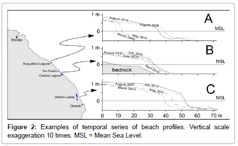
Figure 2: Examples of temporal series of beach profiles. Vertical scale exaggeration 10 times. MSL = Mean Sea Level.
The six third-order subunits belonging to the Torre San Gennaro - Torre Specchia II-o SU (Figure 3) are formed by concave-seaward sandy beaches, each of them was bounded by gentle headlands. Both the Specchiolla-Torre Rinalda and the Torre Rinalda – Torre Chiaca III-o SUs experienced strong urban sprawling from the 1960s. The uncontrolled expansion of buildings and infrastructures adversely affected the others subunits for a lesser extent. During the last two decades, field surveys detected a general shoreline retreat. The strongest erosion was observed within the subunit San Cataldo - Torre Specchia. Moreover, these subunits show the processes of enhanced dismantling of dunes caused by storms. Dunes bordering the Cesine Lagoon (a natural reserve of European Union importance, see Figure 3 for location), were nearly all dismantled over the last twenty years. A series of rock groynes was built to protect the beaches. In the meantime, environmental changes have produced ecological stress in the lagoon and bordering moist areas. South of Torre Specchia the coast is rocky and made up of calcarenites. Along the cliffs some pocket beaches are present, the greatest of which is located at Torre dell'Orso (Figure 1). Due to the coastal morphology, there is no exchange of sand between the Torre dell'Orso pocket beach and the adjacent subunits. Comparing the 1948 IGMI map with the 1988 orthophotos backshore surface was enlarged by 10 (±5) %, north side was in advancement when the south side was in retreat. Over the last twenty years the shoreline of the pocket beach was in dynamic equilibrium. An alternate longshore transport occurs with annual periodicity. The two extreme segments of the beach seasonally prograde and retrograde according to the prevalent wind direction. Usually, the southern one advances during spring-summer when winds from N prevail. In the meantime, the northern side of the beach retreats. During autumn-winter, with dominant winds from S, the trends are inverted. Moreover, losses of backshore caused by boreal Autumn-Winter storms are balanced by spring-summer transfer of sand from the middle-upper shore face to the foreshore. Longitudinal sand bars have large size and temporarily store great amount of sand in the course of the annual exchange between foreshore and shore face. At Torre dell'Orso post storms beach recovery occurs seasonally. Instead, for the other beaches of the entire study area, the recovery may require more years depending on the frequency and intensity of storms. With regard to the physiographic subunit overlooking the Alimini Lakes (Figure 1), a dynamic stability of both the north and the central sides and the advance of the south side were recognized through the field surveys throughout the last twenty years. Comparing the 1948 IGMI map with the 1988 orthophotos, north and central sides appear in retreat when the south side appears stable. Singular weekly and monthly shoreline mobility was observed for the central side due to a large outcrop of the gently sloping bedrock in correspondence of the sea level. Foreshore of this segment is highly sensitive to storms and persistent intense winds. The whole Alimini Lake subunits experience strong erosion during both the autumn/winter 2009-2010 and the autumn/winter 2010-2011 storm events. Longshore bars were almost entirely eroded. After and until the spring/summer 2015, the beach slowly prograded (Figure 2, profile C, March 2010, May 2011, July 2013 lines).
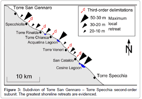
Figure 3: Subdivion of Torre San Gennaro – Torre Specchia second-order subunit. The greatest shoreline retreats are evidenced.
Medium-term trend reconstruction
In situ experience allows for a careful elaboration of the shorelines trend of the Torre San Gennaro – Torre Specchia II-o SU (Figure 3) by interpretations of topographic map, orthophotos and satellite images. This portion of Apulian coast is especially important for both the environmental conservation and the tourism economy. Comparing the shoreline traced on the 1948 IGMI map with shoreline digitalized from the 1988 orthophotos, an enhanced landward shift is clearly evident for the five third-order physiographic units between Torre San Gennaro and San Cataldo (Figure 3). The geometrical computation performed in the study showed mean shoreline retreat estimates of about 10 (±5) m. The 1948-1988 mean landward shift inside the San Cataldo – Torre Specchia III-o SU resulted in significantly smaller (3 ±2 m) estimates.
Such a result is in good agreement with statements of residents and stakeholders. The 1988-2102 shoreline retreat was estimated at 5 ± 2.5 m for the entire second-order unit. The largest retreats inferred over the last 65 years range from 30 to 50 (±10) m and have adversely affected several segments of foreshore of tens of metres long (Figure 3). Severe beach erosion began in the early 1990s at the San Cataldo - Torre Specchia III-o SU (Figure 4) as surveyed on field and illustrated by the positions of the digitalized instantaneous shorelines. Especially the beach overlooking the Cesine Lagoon was adversely affected by enhanced retreat, thus altering the ecological equilibrium of the site. Outcrops of the calcarenitic bedrock are spread over both the foreshore and the upper-middle shore face, thus making small the space available for beach sediments and highly responsive the nearshore morphology to wave climate changes. Longitudinal rock groynes have been built since the early 2000s to contrast the loss of beach and they have produced partial recovery (Figure 5). A second portion of San Cataldo – Torre Specchia III-o SU affected by significant shoreline mobility throughout the last two decades is that of Figure 6. As well as the beach overlooking the Cesine Lagoon, bedrock diffusively outcrops over both the foreshore and the contiguous portion of shallower sea floor. The constructed transversal groynes have interrupted the prevalent southeastward longshore transport. Meantime, erosion process intensity decreased and shoreline was dynamically stable until surge storms occurred on autumn/winter 2009-2010 and autumn/winter 2010- 2011. Throughout the last four years and until the summer 2015, some portions of the shoreline were in moderate seaward shift as shown by temporal profiling (Figure 2, profile B, April 2010, June 2012, August 2015 lines).
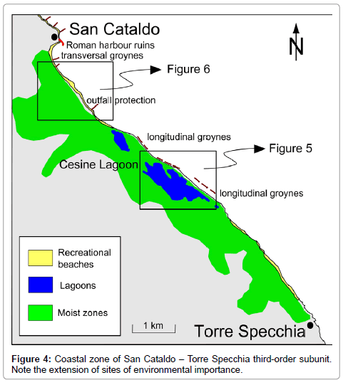
Figure 4: Coastal zone of San Cataldo – Torre Specchia third-order subunit. Note the extension of sites of environmental importance.
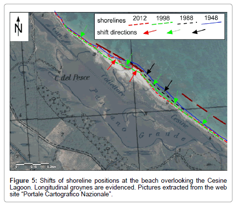
Figure 5: Shifts of shoreline positions at the beach overlooking the Cesine Lagoon. Longitudinal groynes are evidenced. Pictures extracted from the web site “Portale Cartografico Nazionale”.
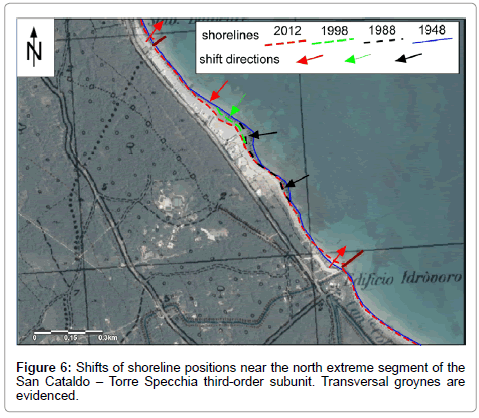
Figure 6: Shifts of shoreline positions near the north extreme segment of the San Cataldo – Torre Specchia third-order subunit. Transversal groynes are evidenced.
Discussion
The medium-term erosion processes above reported may be due to the following causes: sea level rise; changes in extreme storm surges; variations of sediments supplies; human-induced processes; tectonic subsidence.
Sea level rise
Mediterranean mean sea level rose of about 1.2 mm/yr during the XX century. It is about 2/3 of the global estimated SLR and shows peculiar trends. During the early 1960s and the early 1990s Mediterranean Sea level did not change or even decrease. Next two decades feature SLR, especially throughout the eastern Mediterranean, with a strong interannual variability as showed by satellite altimetry data [15]. An about 0.1 m drop of the sea level occurred in the Ionian Sea, partially influencing the south Adriatic Sea, during 1998 [16]. Such an event adds uncertainty about the incidence of the sea level changes on the sedimentary dynamics of the studied coast. However, for the southern Adriatic, for the whole second half of the XX century an increase of about 0.05 m of the sea level has been estimated [15]. It is of three orders of magnitude lower than the mean shoreline retreat for the studied case.
Changes in extreme storm surges
Storm surges are mainly due to low pressure and strong winds. To sketch the changes in the Mediterranean storminess is a problematic issue as it is usually reported in literature. According to the 40-year sea level pressure data by Maheras et al. [17], the frequency of the cyclones in the western Mediterranean decreased up to the late 1990s, while in the eastern Mediterranean it slightly increased. For the storm surge seasonal variability, databases analysis of meteorological sea level component indicates a six-decade negative trend and a two-decade positive trend up to the late 2000s [18]. For the Adriatic Sea, the studies stressed a positive storm surge trend throughout the 1990s and the 2000s that was a period of enhanced erosion processes and peculiar shoreline mobility for the physiographic units considered in this study. The series of extreme events happened during the boreal Autumn/ Winter 2009-2010 and 2010-2011, and thus, it can be inversely related to the monthly North-Atlantic-Oscillation (NAO) index [19]. The mean level of the Mediterranean Sea rose by about 0.1 m above the average climatological value. Most likely, such an increase in the sea level has played a key role to determine the retreats of shorelines above described.
Variations of the sediments budgets
Variations of the amount of sand available for the sedimentary budgets of the physiographic units may depend on both natural and human-induced factors. Currently, the main promontories delimiting the Brindisi – Otranto I-o SU do not allow for the exchange of sand with the adjacent units and along the studied coast there are no mouths of rivers supplying sand. Only some short torrents (carrying few amount of mud) flow to the sea between Brindisi and Torre San Gennaro (Figure 1). Siliciclastic terrigenous component of the studied beaches is a heritage of previous coastal setting. It was transported from the river mouths located at north and central sides of Apulia from the Middle Pleistocene. Probably, the supply of siliciclastic grains to the Brindisi – Otranto I-o SU was interrupted when sea level reached about the present position during the Holocene rise. It should be important to establish changes of carbonate production of the shallow-water factories over the last decades but data are scarce [11]. Human activities have reduced the total volume of sand for more than one century. As reported in documents consulted at the Italian Archive of State, the dunes of the Salento peninsula were used for sand mining to begin the late XIX century. Initially, sand was used to ballast the boats. In the first half of the XX century it was mainly used to fill up coastal swamps with the aim to defeat the plague of the malaria. In more recent times, huge portions of dunes and upper backshore were removed, without any supervision, for coastal urbanization sprawling. The total amount of sand removed is unknown but is most likely to be the same size as the one lost due to natural processes.
Human-induced processes
In addition to the sand mining, other human activities may have determined erosion processes along the studied coast. Transversal groynes and outfall protections obstruct longshore transport of sand and when they are rather long and deep may provoke transfer of sand from nearshore to middle-lower shore face. The construction of coastal defences has definitely changed the sedimentary budget of several physiographic subunits belonging to the studied coast. As an example, for the San Cataldo – Torre Specchia III-o SU (Figures 4-6) the transversal groynes built at its northern extreme segment have reduced the possible supply from the adjacent subunit. Previously the only obstacle for longshore transport was the ruins of a Roman harbour. However, due to the lack of monitoring data, the assessment of such a process appears to be very subjective. Moreover, also the removal of the Posidonia oceania banquettes for recreational activities on beach has produced an unquantifiable loss of sand. Incidentally, it must be reported that the first project of the Posidonia oceania banquettes removal found in the Italian Archive of State for the studied coast, dates back to the early 1900s. Among the few studies regarding the sedimentary effects of the banquettes management, it should be noted that De Falco et al. [20] estimated for the beaches of Sardinia up to approximately two thousands of cubic meters of sand yearly lost. These amounts could cause a significant shoreline shift in the low-lying coastal zones.
Tectonic subsidence
Usually, subsidence causing shoreline retreat is due to fluid (groundwater, fossil oils) pumping. This process does not concern the coastal aquifer of the Salento peninsula. Instead, several features of the coastal landscape suggest active tectonic subsidence. Moreover, some mediaeval towers have their base up to about 1 m below mean sea level [21]. The computable tectonic subsidence is too small to have made a quantifiable impact on the described sedimentary dynamics.
As described above, over the second half of the XX century and the 2000s, the beaches of the study area were undergoing erosion. As a whole, the loss of beach can be estimated at 20 (±10)% of the beach surface area drawn on the 1948 IGMI map. The amount of shoreline retreat has however changed in time and in space. Unfortunately, the total flux of sediments from upper shore face to lower shore face is not determinable. Also the amount of possible offshore transports of sand during storms is unknown. Nevertheless, the collected data help to determine changes in dynamics and processes that occurred two decades ago. Since the 1960s and until the early 1990s, the San Cataldo – Torre Specchia III-o SU underwent less strong erosion than the other subunits belonging to the Torre San Gennaro – Torre Specchia II-o SU. The latter experienced huge sand mining caused by urban sprawling. Meantime, the mean sea level did not change or decrease [15] and changes in storminess should be not relevant [17,18]. Over this period of time, the human-induced processes were the main cause of erosion with little uncertainty. Dominant south-eastward longshore transport has allowed for a net transfer of sand to the San Cataldo – Torre Specchia III-o SU that has proven to be relatively more stable. To try to establish how much the positive Mediterranean SLR (basin average value of 1 mm/yr) since the early 1990s [15] has contributed to the erosion processes of the studied coast, the effects of the other causes must be considered. Mean shoreline retreats of 5 (±2.5) m from the late 1980s to the early 2010s have been estimated for the 35-km long second-order subunits Torre San Gennaro – Torre Specchia (Figures 1 and 3). Hence, the rate of the landward shoreline shift was of two orders greater than the rate of SLR. Such a ratio may be assumed to consider SLR as the main cause of the coastal erosion [5]. However, the beaches experienced retro gradation also when sea level did not increase [15]. The uncertainty of the assessment grows considering that over the last two decades a positive trend of the storm surges developed [18]. Finally, the human-induced processes have surely determined not negligible effects. If the coastal urbanization sprawling was stopped before the early 1990s, the recreational and touristic pressures over the beaches increased throughout the last two decades. Moreover, the construction of coastal defences took place without any forecast of the inducted effects. Most likely, especially the longer and deeper transversal groynes may provoke transfer of sand from nearshore to lower shore face. Consequently, it is simplistic to suppose synergies among the causes of erosion, whereas it would be a hard task to establish their rank of importance. However, the observed shoreline mobility has involved a complex physical reorganization of sedimentary materials and not only the landward shift of shore face along the beach profile [4,5]. Dismantling of dune systems, longshore sediments transport, migration of submerged coastal bars, sediments exchanges between upper shore face and lower shore face and other sedimentological processes of the submerged part of the beaches must be considered to explain the observed dynamics [22].
The increased storm surges that occurred in the boreal autumn/ winter 2009-2010 and autumn/winter 2010-2011 were correlated with the monthly NAO index [19]. Strong erosion effects have been surveyed at the studied beaches. The rise of about 0.1 m above the average climatological values has determined large retreats of shorelines. The beaches have partially recovered the loss of sand after some seasonal cycles. Only the dynamics of a pocket beach is apart from the others recovering shortly after (few months) the extreme events. Taking into account that several models suggest an increase in the NAO index over the XXI century [23], the development of tools for the integrated management of the coast will become an engaging challenge, especially in view of further SLR. The economic relevance of the coast for the tourism industry, the importance of several habitats and the uncertainty about the magnitude of erosion processes shows the pressing need to define the strategy. Improved understanding and knowledge appears to be necessary but insufficient for such a target. Associated uncertainties seem to hinder the adoption of best management practices even though large uncertainties are rarely a restrictive factor for actions [24]. Mitigation actions are needed to establish impassable thresholds of risk, while adaptation actions are needed to elaborate on long-term accommodation plans for both anthropic and natural environments. Therefore, considering the interdisciplinary context of ICZM, the coastal management could be enhanced through cooperation and coordination by researchers, residents and stakeholders trying to reach a difficult agreement between natural and social sciences.
Acknowledgements
Orthophotos were downloaded from the web site “Portale Cartografico Nazionale” of the Italian Minister of Environment; Satellite Images from Google Earth. Research was published with SIGIEC project funds (responsible C. R. Calidonna).
References
- Bird ECF (1987) The Modern Prevalence of Beach Erosion. Mar Pollut Bull 18: 151-157.
- Hanson H, Lindh G (1993) Coastal Erosion - An Escalating Environmental Threat. Ambio 22: 188-195.
- Phillips MR, Jones AL (2006) Erosion and tourism infrastructure in the coastal zone: Problems, consequences and management. Tourism Manage 27: 517-524.
- Bruun (1988) The Bruunrule of erosion by sea-level rise: a discussion on large-scale two- and three-dimensional usages. J Coastal Res 4: 627-648.
- Leatherman SP, Zhang K, Dougls BC (2000) Sea level rise shown to drive coastal erosion. Eos 81: 55-58.
- Dal Cin R, Simeoni U (1987) Erosion and sediment transport in the Apulian beaches between Santa Maria di Leuca and Taranto ( Ionian Sea ) . Possible intervention strategies. Boll SocGeolItal 106: 767-783.
- Caldara M, Centenaro E, Mastronuzzi G, Sansò P, Sergio A (1999) Features and Present Evolution of Apulian Coast (Southern Italy). J Coastal Res SI 26: 55-64.
- Delle RM, Leucci G (2010) Towards an integrated approach for characterization of sinkhole hazards in urban environments: the unstable coastal site of Casalabate, Lecce, Italy. J GeophyEng 7: 143-154.
- Delle RM, Beccarisi L, Elia T (2011) Short-medium term assessments of coastal erosion and marine inundation effects on natural and anthropic environments (Apulia, Southern Italy). In: Brugnoli E, Cavarretta G, Mazzola S, Trincardi F, Ravaioli M, Santoleri R (editors), Marine Research at CNR, Coastal and Marine and Spatial Planing, National Research Council of Italy, 1149-1163.
- Tropeano M, Spalluto L (2006) Present-day temperate-type carbonate sedimentation on Apulian Shelves (southern Italy). GeoActs 5: 129-142.
- Zito G, Ruggiero L, Zuanni F (1991) Aspects of weather and climate of Puglia. Proceedings of the First Workshop on Climate, Environment and Territory43-73.
- Delgado I, Lloyd G (2004) A Simple Low Cost Method for One Person Beach Profiling. J Coastal Res 20: 1246-1252.
- Boak EH, Turner IL (2005) Shoreline Definition and Detection: A Review. J Coastal Res 21: 688-703.
- Gomis D, Tsimplis M, Marcos M, Fenoglio-Marc L, Pérez B et al. (2012) Mediterranean Sea-Level Variability and Trend. In: Lionello P (editor) The Climate of the Mediterranean Region, From the Past to the Future 4 257-300.
- Soto-Navarro J, Del RVera J, Criado-Aldeanueva F, Garcia-Lafuente J, Naranjo-Rosa C et al. (2009) Sea Level Trend Changes in the Ionian Sea in Relation to the Eastern Mediterranean Transient. In: Wright LL (editor), Sea Level Rise, Coastal Engineering, Shoreline and Tides, Chapter 12, Nova Science Publishers 263-268.
- Maheras P, Flocas HA, Patrikas I, Anagnastopoulou CHR (2001) A 40 year objective climatology of surface cyclones in the Mediterranean region: spatial and temporal distribution. Int J Climatol 21: 109-130
- Cid A, Castanedo S, Abascal AJ, Menéndez M, Medina R (2014) A high resolution hindcast of the meteorological sea level component for Southern Europe: the GOS dataset. Clim Dynam 43: 2167-2184.
- Felix W, Landerer FW, Volkov DL (2013) The anatomy of recent large sea level fluctuations in the Mediterranean Sea. Geophys Res Lett 40: 553-557.
- De Falco G, Simeone S, Baroli M (2008) Management of Beach-Cast PosidoniaoceanicaSeagrass on the Island of Sardinia (Italy, Western Mediterranean). J Coastal Res 24: 69-75.
- Mastronuzzi G, Sansò P (2014) Coastal towers and historical sea level change along the Salento coast (southern Apulia, Italy). QuaternInt 332: 61-72.
- Cowell PJ, Stive MJF, Niedoroda AW, Swift DJP, De Vriend HJ et al. (2003) A conceptual approach to aggregated modelling of low-order coastal change. J Coastal Res 19: 812-827.
- Christensen JH, Hewitson B, Busuioc A, Chen A, Gao X, et al. (2007) Regional climate projections. In: Solomon S, Qin D, Manning M, Chen Z, Marquis M et al. (editors), Climate Change 2007: The Physical Science Basis, Cambridge University Press, 849-940.
- Billé R (2008) Integrated Coastal Zone Management: four entrenched illusions. SurvPerspectIntegr Environ Soc 1: 75-86.
Citation: Delle Rose M (2015) Medium-term Erosion Processes of South Adriatic Beaches (Apulia, Italy): A Challenge for an Integrated Coastal Zone Management. J Earth Sci Clim Change 6(9): 306. DOI: 10.4172/2157-7617.1000306
Copyright: © 2015 Delle Rose M. This is an open-access article distributed under the terms of the Creative Commons Attribution License, which permits unrestricteduse, distribution, and reproduction in any medium, provided the original author and source are credited.
Select your language of interest to view the total content in your interested language
Share This Article
Recommended Journals
Open Access Journals
Article Tools
Article Usage
- Total views: 11924
- [From(publication date): 11-2015 - Aug 30, 2025]
- Breakdown by view type
- HTML page views: 10938
- PDF downloads: 986