Role of Equatorial Fracture Zones on Fluid Migration across the South Atlantic Margins
Received: 25-Sep-2012 / Accepted Date: 06-Mar-2013 / Published Date: 08-Mar-2013 DOI: 10.4172/2157-7617.S12-004
Abstract
The continental margin basins of Brazil and West Africa share very similar tectono-stratigraphic megasequences that are recognizable in petroliferous basins, as a result of the Late Jurassic-Early Cretaceous rifting of the South Atlantic basins. A number of oil families present along the South Atlantic conjugated margins are composed of genetically related oils of mixed provenance. Motion of tectonic plates and their configurations which depend so much on the nature of the boundaries and their orientations strongly influence fault tectonics within both continents The tectonic evolution of the plates leads to the formation of fracture zones parallel to the direction of plate motion. The Middle Benue Trough of Nigeria and by extension, the whole Benue Trough, is bound by two offshore transform faults (the Chain and the Charcot Fracture Zones). These faults are asymmetric longitudinally with an oblique transverse fault bounding the basin, and have been outlined by the presence of magnetic lineation. Five E-W profiles across the Middle Benue Trough were selected for the application of Werner deconvolution and subjected to harmonic analysis. The magnetic dataset was used in concluding that the Equatorial Fracture Zones (EFZ) in the South Atlantic Ocean extending from South America into the Gulf of Guinea are mainly responsible for long distance migration of marine hydrocarbons from the West Africa margin to the offshore of Brazil.
Keywords: Tectonic plates; Fracture zones; Equatorial Fracture Zones (EFZ)
10386Introduction
Over the past few years, the hydrocarbon-bearing sedimentary basins along the South Atlantic continental margins have undergone a surge of expanded exploratory interest. This has in part been fueled by discoveries of giant fields such as Bonga, Zafiro, N’kossa Girassol, Dalia, Roso and Kuito along the West African margins and the Rocador, Marlim, Barracuda and Albacora Leste in the Campos Basin along the South American margin [1].
The Benue Trough of Nigeria is an intra-cratonic rift structure that extends from the northern limit of the Niger Delta to the southern margin of the Chad Basin [2]. Total-field aeromagnetic anomaly data from the Middle Benue Trough (MBT) used in this work were part of the aeromagnetic maps of the total field intensity in half degree sheets acquired by the Federal Government of Nigeria between 1974 and 1976 to assist her in mineral and groundwater development through improved geological mapping. Flight line direction was NNW-SSE (N150E) at station spacing of 2 km with flight line spacing of 20 km at an ENE-WSW (N60E) direction. Each of the twenty sheets covering this area of study was digitized at 1.5 km intervals along the longitudinal and latitudinal offsets and the International Geomagnetic Reference Field (IGRF) removed. We took advantage of these surveys and reviewed the harmonic expansion of magnetic data of the MBT for this work. The International Geomagnetic Reference Field (IGRF)- corrected total field aeromagnetic data over the MBT were upward continued to a height of 100 km and compared with the application of low-pass filtering, the aim of which is to accentuate the effects of deep-seated structures. In addition, five E-W profiles across the study area were selected for the application of Werner deconvolution and subjected to harmonic analysis. The results from the analyses of the magnetic data over the study area are discussed.
The main objective of this paper is to show that the deep-seated structures detected in the MBT and by extension through the entire Benue Trough are part of the EFZ responsible for long distance migration of marine hydrocarbons from the West Africa margin to the offshore of Brazil.
Geology and Aeromagnetic data of the Middle Benue Trough
The Middle Benue Trough (MBT) (Figure 1) is part of the entire Benue Trough of Nigeria (Figure 2). It lies between latitudes 7°00’ N’ and 9°30’N’ and longitude 9°00’E’ and 11°30’E’. The lithostratigraphy of the MBT has been described by Offodile and Obaje et al. (2008) [3,4] produced an idealized stratigraphic cross-section across the Benue Trough (Figure 3). Major Santonian tectonic events have affected the Albian to Coniacian sediments, producing numerous folds, faults and fractures. These events were accompanied by mafic to intermediate volcanic activity that led to the emplacement of dykes, sills, lavas and tuffs [5-7]. Consequently, most parts of the Lower and Middle Benue were uplifted with more than 1000 m of sediments eroded.
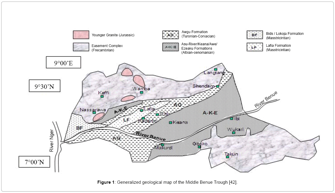
Figure 1: Generalized geological map of the Middle Benue Trough [42].
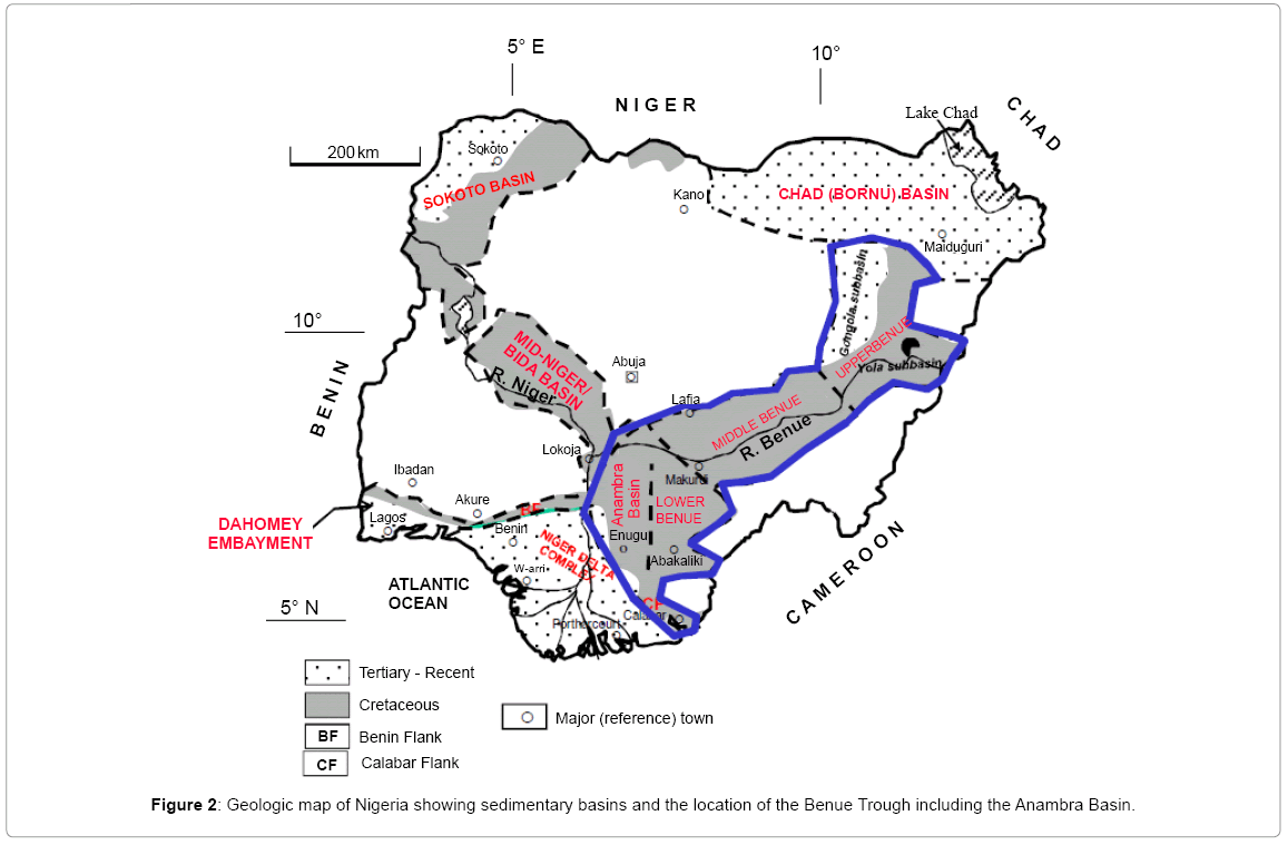
Figure 2: Geologic map of Nigeria showing sedimentary basins and the location of the Benue Trough including the Anambra Basin.
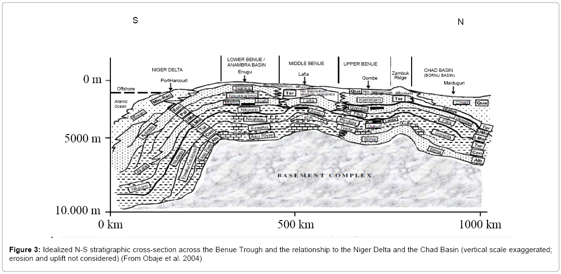
Figure 3: Idealized N-S stratigraphic cross-section across the Benue Trough and the relationship to the Niger Delta and the Chad Basin (vertical scale exaggerated; erosion and uplift not considered) (From Obaje et al. 2004)
Two-dimensional harmonic analysis has been used in this study as a tool for the interpretation of magnetic data. In this method, we have made use of the Laplace equation, which is the fundamental relationship of potential theory to expand the total anomaly field aeromagnetic intensity over the MBT. A potential U, which is a continuous function of space coordinates, is expressed as, if ΔT is the total field magnetic anomaly in the direction of the earth’s magnetic field, then
Where ΔU is the anomaly in magnetic potential U and η is a unit vector in the direction of the earth’s field. A feature in the analysis involved the upward continuation and low-pass filtering in wave number domain of the magnetic data. The resulting anomaly map is displayed in Figure 4. The map shows contour values ranging from -750 to 100 nT, with a northeast-trending pattern of low relief magnetic values in the central and southeastern parts of the area, surrounded by the high-relief areas in the northwest part of the map.
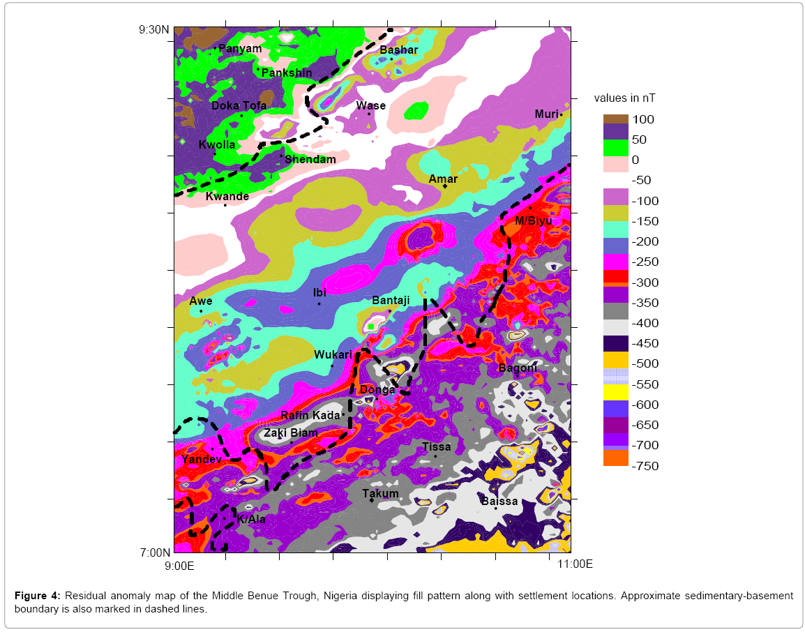
Figure 4: Residual anomaly map of the Middle Benue Trough, Nigeria displaying fill pattern along with settlement locations. Approximate sedimentary-basement boundary is also marked in dashed lines.
The data were continued upward to an elevation of 100 km above flight height (Figure 5). This process highlights the low wave number components in the observed field at this level, which are likely to be the effects of deeper sources, interference and shallow plate sources. Upward continuation of the data to 40 km above the flight height was also carried out for comparison.
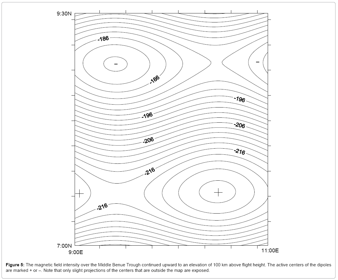
Figure 5: The magnetic field intensity over the Middle Benue Trough continued upward to an elevation of 100 km above flight height. The active centers of the dipoles are marked + or –. Note that only slight projections of the centers that are outside the map are exposed.
Trials with other wavelengths indicate that those ≥ 150 km have a closer resemblance to the 100 km upward-continued field and thus the wavelength limit of 150 km gives a pattern similar to that of Figure 5. It is concluded that for this study area, the effect of upward continued data at 100 km is equivalent to discerning the effects of structures of wavelengths 150 km and above.
Five profiles were selected (Figure 6) on the original aeromagnetic anomaly map of the MBT for depth estimates using Werner deconvolution. Interpretation method, known in practice as Werner deconvolution (or Werner technique) was developed from the approach submitted by Werner [8] and introduced to the practice of geophysicists at the end of the 60’s as part of an automated interpretation system for processing and interpretation of aeromagnetic profile measurement. The Werner total field solution provides a close approximation when the geologic body is an infinitely long thin dyke. Thus geologic bodies that vary transitionally from a thin dyke to the edge of a thick interface can be investigated conveniently with the Werner deconvolution technique.. The result of the Werner profile analysis have revealed depths that nowhere exceeded 4.80 km for the sedimentary thickness and also shown a pattern of basement structure that has been deformed into tilted fault blocks having a general N-S trend.
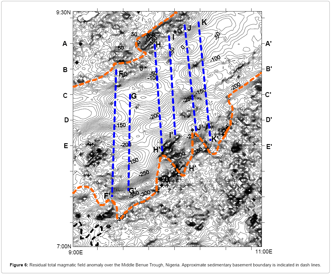
Figure 6: Residual total magmatic field anomaly over the Middle Benue Trough, Nigeria. Approximate sedimentary basement boundary is indicated in dash lines.
Four “regional” maps used earlier by Likkason [9] supported the concept of two dipoles. One dipole in the lower diagonal half of the area has its South Pole (-) center located in the region outside the study area, while the other dipole has the center of its North Pole (+) hidden outside the study area. This coincided with what obtains in Figure 5. Thus only the South Pole of one dipole and North Pole of the other dipole are exposed in the study area and are respectively centered at the sedimentary-basement boundary and within the basement.
The origin of these dipoles is from the consequences of the deepseated parallel continental extensions of oceanic fracture lines. The asymmetric nature of the two dipoles suggests that the dominant tensional regime was that of longitudinal stretching along a corridor spread of probably N36°E to N65°E as seen by the dipolar pattern. The N65°E trend is exactly the trend of the main Benue River (Figures 1 and 2). The Benue River is thus likely to be fault controlled. The differential transverse response of this stretching was the fault zone whose direction is N140°E and coincides with the trend of volcanic rocks which are dominant in the sedimentary basin as well as in the basement complex [10]. The directions of the block movements are permitted only when the third fault is positioned parallel/subparallel to the trend of the Benue River (Figures 1 and 2).
The asymmetry in this basin might have resulted from simultaneous strike-slip motion and a fault-normal extension, similar to a way asymmetry is produced in large transform basins [11,12]. The resulting asymmetric configuration of the dipole is believed to be an indication of the pull-apart nature of the basin. The necessary criterion for such a model is that the basin or trough must be formed at places where bends or stopovers occur along the trace of the strike-slip faults, leading to en echelon segmentation of the faults [12]. The model must also predict two longitudinal sides of the basin be bounded by strike-slip faults, while transverse faults, which trend diagonally to the strike-slip fault be predominantly normal [13]. This is exactly the dipolar set-up of the MBT as depicted in Figure 7.
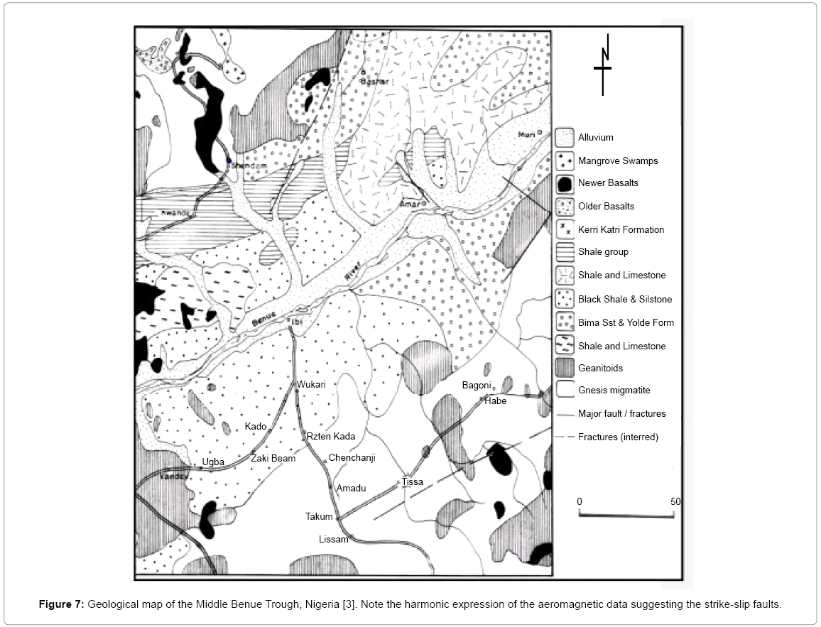
Figure 7: Geological map of the Middle Benue Trough, Nigeria [3]. Note the harmonic expression of the aeromagnetic data suggesting the strike-slip faults.
This observation suggests that the oblique transform faults which bound the basin sides are not secondary features that evolved in response to increasing strain, but are fundamental features that form an integral part of the controlling transform fault system. If the asymmetry was formed during periods of oblique extension, then stratigraphic records of the basin will confirm it.
Along these transverse faults there are seen subtle disruptions of Bouguer anomalies as described in Cratchley and Jones [14]. Benkhelil [2] had earlier attributed the characteristic extensional features found along the Benue Trough to divergent strike-slip movement along deepseated faults. He concluded that the propagation onshore of transcurrent movement with a slight divergent component, eased by old lines of weakness of the basement parallel to the transform fault, was enough to originate pull-apart basins and other extensional features.
Equatorial Fracture Zones (EFZ)
Five NE-SW trending oceanic fracture zones (Figure 8) have been mapped in the offshore Niger Delta to the northeast of the Gulf of Guinea [15]. They include the Romanche Fracture Zone located along the northern part of the Gulf of Guinea, the Chain Fracture Zone, extending near the Niger Delta and the Charcot Fracture Zone, conspicuously forming a volcanic relief. The other two that dissect the Nigerian coast are the Fernando Po Fracture Zone [16] bounding the Guinea Ridge to the north and marking the southern limit of the Niger deltaic complex and the Ascension Fracture Zone, which constitute the southern boundary of the Guinea Ridge.
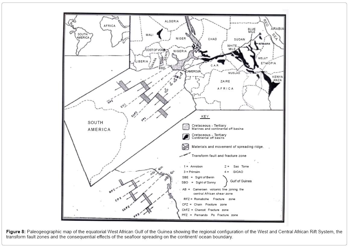
Figure 8: Paleogeographic map of the equatorial West African Gulf of the Guinea showing the regional configuration of the West and Central African Rift System, the transform fault zones and the consequential effects of the seafloor spreading on the continent/ocean boundary.
Fracture zones are major lines of weakness in Earth’s crust that cross the mid-oceanic ridges at approximately right angles. They extend for thousands of kilometers across ocean floors, generally heading straight for continental margins. Although fracture zones are difficult to trace where they are buried by sediments of the abyssal plain and the continental rise, extensions of fracture zones have been traced onto continents. Some major structural trends on continents lie along the extension of fracture zones onto the continents (Figure 9).
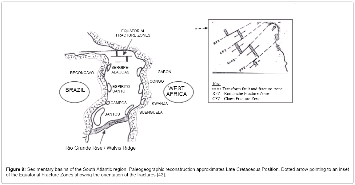
Figure 9: Sedimentary basins of the South Atlantic region. Paleogeographic reconstruction approximates Late Cretaceous Position. Dotted arrow pointing to an inset of the Equatorial Fracture Zones showing the orientation of the fractures [43].
The most important EFZ, the Romanche Fracture Zone is probably linked with the structural trends of the basement west of the Benue Trough [17,18]. Fail et al. [19] showed its probable extension onshore along the northern margin of the trough. The Chain and Charcot Fracture Zones are believed to have continental extensions and are probably linked to the major fracture system that runs along the axis of the Benue Trough (Figure 2) beneath the sedimentary cover.
The evolution of the Benue Trough commenced with the occurrence of the oceanic transform faults themselves, probably initiated due to old lines of weakness within the Pan African mobile belt [20]. It appears from the various hypotheses on the origin of the Benue Trough [21-23] that all the mechanisms put forward to “open” the trough involve more or less extension acting at nearly right angles to the trend of the trough, leading to a graben structure, a center of igneous activity and sedimentary infilling.
The motion of tectonic plates and their configuration depends so much on the nature of the boundaries and their orientations. The joining of these two independent spreading centers in the Early-Mid Cretaceous resulted in a major shear zone developing between west Africa and the northern margin of Brazil that subsequently opened to form the equatorial Atlantic [24]. Within Africa, the accommodation of differential plate movements exhibited in the opening of the equatorial Atlantic has resulted into the development of major shear/wrench zones and a passive continental rift system [24,25]. The equatorial West African Gulf of Guinea hosts structural networks that started with a triple junction which dispersed giving rise to a 3-way radial fracture system on the Gondwanaland: two rifted, leading to the opening of the South Atlantic. The other “failed” arm, led to the evolution of the Benue Trough system (Figure 2). These faults, visible as the trend of fracture zones offsetting the Mid-Atlantic Ridge axes are regarded as “flow lines”, tracing the movement of the separating plates. They probably linked the faults of the Benue Trough with the fault zones affecting sandstones basins in Brazil, such as the Reconcavo Basin and strongly influence fault tectonics onshore and offshore on both continents and at all scales.
The oceanic fracture zone, (Romanche, Charcot and Fernando Po) [26] has already been linked, respectively with northeast and southwest of the Gulf of Guinea [15] and thus map the boundaries of the Benue Trough. These structural trends, believed to have formed during the opening of the Mid-Atlantic Ocean in the Late Jurassic-Early Cretaceous times [27], stretched into the deep ocean to the eastern part of Brazil. Inside the African block, one set of the fractures (Romanche Fracture Zone) trends northwards through Niger towards Libya and the other (Charcot Fracture Zone) eastwards through Chad into Sudan and Kenya (Figure 8).
Petroleum systems
A petroleum system is defined by a mature source rock supplying hydrocarbons into a migration network and ultimately into a hydrocarbon traps [28]. It also defines the relationship between geologic elements and process in time and space in order to understand the driving forces behind the distribution of hydrocarbon provinces.
The sedimentary basins along the South American and west African margins (Figure 9) are traditionally considered to be independent basins, partly because of the absence of common stratigraphic nomenclature for the existing lithologies [1]. Along the Brazilian margin, virtually all of the hydrocarbons discovered originated from Lower Cretaceous lacustrine facies, including the Lagoa Feia Formation [29] in the Campos Basin and an age-equivalent section in the Reconcavo and Espirito Santos Basins (Figure 9). Along the west African margin, most fields discovered early in the exploration history of the basins appear to have been sourced by lacustrine facies of the Lower Cretaceous Bucomazi Formation or its equivalents [30-32]. Recent drilling, however, suggest that younger Cretaceous and even Tertiary source intervals with marine affinity may be supplying significant hydrocarbon volumes to the petroleum systems.
Marine oils derived from different post-salt (Upper Cretaceous- Tertiary) source rocks are also present on both sides of the South Atlantic. West African marine oils are primarily from Ivory Coast and Gabon (Port Gentil area), lower Congo, kwanza and Benguela Basins. Marine oils from offshore Brazil are present in the Santos, Espirito Santo, and Sergipe-Alagoas Basins (Figure 9). However the marine source rocks present in the Brazilian marginal basins have insufficient overburden for generation to proceed. In contrast, sufficient overburden is present, at least locally, along the west African margin for generation to take place [33,34]. For the marine affinity hydrocarbons to be present at the offshore of Brazil, the oils must have migrated from the African margin to the South American margin.
The equatorial faults, parallel to the direction of plate motion, more susceptible to reactivation are believed to be responsible for the longdistance migration (Figure 10).
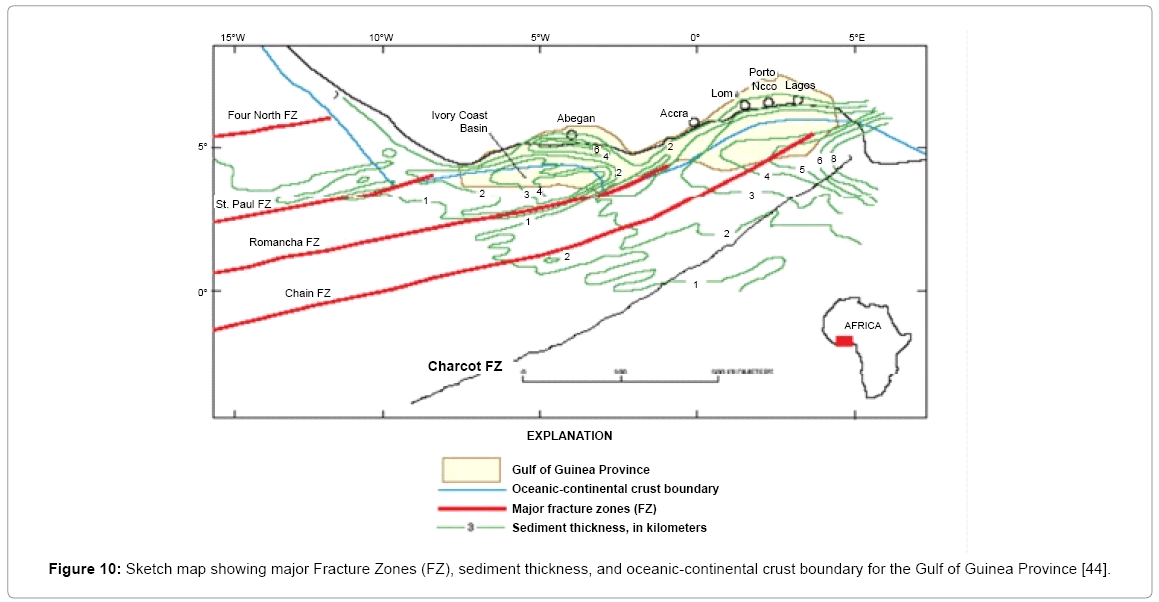
Figure 10: Sketch map showing major Fracture Zones (FZ), sediment thickness, and oceanic-continental crust boundary for the Gulf of Guinea Province [44].
Long distance migration and early entrapment of hydrocarbons from deep part of a basin towards the infilling of prerift and synrift reservoirs have been investigated, highlighting migration routes and the role of faults as possible migration patterns in reservoirs [34]. Faults can act as efficient migration pathways, even if they appear to be sealing at the present time [35-37]. Bouguer gravity data representing an approximation of the structural configuration of the Tertiary basin at some point in time prior to very early development of the Niger Delta region in Nigeria shows a series of NE-SW trending structural highs and lows, present beneath the delta [27]. Structural lows are deeper than 11 km and in some areas influence drainage patterns today. These lows are inferred to represent sub-basins and possibly separate hydrocarbons kitchens onshore [27]. No large petroleum accumulation has been identified to date from the Upper Cretaceous-Lower Paleocene source in the Niger Delta region [27]. This older petroleum system, which is the major source for liquid hydrocarbons in deep-water areas of the Niger Delta [27], has its oil kitchen onshore, present within the rift sequence of the Benue Trough. Samaila et al. [4] explained that the faults acted as conduit for the long distance migration of hydrocarbons from the oil kitchen in the Upper Benue Trough to offshore reservoirs in the Niger Delta region (a distance of more than 1000 km). In the Reconcavo Basin, one of the most prolific onshore Brazilian basins, migration patterns from the deep part of the basin to the prerift and synrift reservoirs have also been established, showing the role of faults and the effects of long-range migration in the infilling of reservoirs.
Discussion and Conclusions
The Early Cretaceous (130-98 Ma) period was the main time of rift development. The origin of the Benue Trough and by extension the West and Central African System (WCAS) is attributed to the breakup of Gondwanaland and the start of separation between Africa and South America. The gradual opening of the Central and South Atlantic at the start of the Early Cretaceous was when wrench fault zones extended from South America into the Gulf of Guinea and Africa, where the strike-slip movement dissipated into extensional basins in Niger, Sudan and Kenya. Sinistral block movement of the West African Craton relative to the Congo Craton caused transtensional opening of the West African System (WAS) in the Benue-Bornu region.
The two major tectonic phases of rifts within the WCAS as recognized by Guiraud and Wilson [24] are: (1) Neocomian-Early Aptian (ca.144-117 Ma): rifting began in the basins of east and northeastern Brazil, Gulf of Guinea, southern Chad, Sudan, Kenya, north and eastern Niger, northern Egypt and Libya. Late Jurassic magmatic activity appears to precede this rifting phase in northeast Brazil, southern Sudan and the Benue Trough of Nigeria and (2) Middle-Late Aptian-Albian (ca.117- 97 Ma): evidenced in the intracontinental basins of the West and Central Africa. The end of this rifting event is marked by a major unconformity along the Gulf of Guinea and northeastern Brazil margins at the end of the Albian (ca. 100 Ma), which is clear marker of the opening of the equatorial Atlantic [38]. The Early Cretaceous onset of basin formation, which was associated with rifting along the margins of the South Atlantic [23], lasted for 30 Ma for the Benue Trough [24]. This rifting phase was said to be evident by faulting and sedimentation (initially lacustrine and later marine) accompanied by only minor volcanism.
The MBT, and by extension, the whole Benue Trough, is bound by two offshore transform faults (the Chain and the Charcot Fracture Zones). These faults are asymmetric longitudinally with an oblique transverse fault bounding the basin, and have been outlined by the presence of magnetic lineation.
The aeromagnetic intensity field anomaly of the basin has been continued upward to an elevation of 100 km above flight height. This was followed by progressive application of low-pass filters, the upward continued field, which usually reveals the effects of deeper sources, is interpreted to be due to two juxtaposed magnetic dipoles of dipolar length approximately 200 km. The configuration of the dipoles suggests an asymmetric geometry and has implications for the tensional regimes that prevailed in the area. The basement topography has a NE-SW oscillatory pattern revealing a maximum wavelength of 50 km with a tilted block-faulting pattern in which the anti-form correspond to the trend of the inter-tonguing basement in some portions of the basin.
The magnetic dipolar interpretation given to the 100 km upward continued field suggests that the MBT (and indeed the entire Benue Trough) is bounded at the two longitudinal sides of the basin by strikeslip faults, with an oblique transverse fault trending diagonally to these wrench or transform faults. The resulting asymmetric configuration of the dipole is believed to be an indication of the pull-apart nature of the basin. This observation suggests that the oblique transform faults which bound the basin sides are not secondary fractures that evolved in response to increasing strain, but are fundamental features that form an integral part of the controlling transform fault system.
Long-distance migration of marine affinity hydrocarbons from the west African margin to the offshore of Brazil, where it is present today, required conduits. Faults parallel to the direction of plate motion can affect both volumetric estimates and reservoir management of a hydrocarbon-bearing structure [39]. At the basin scale, faults define regions of similar subsidence history, control patterns of sedimentation, and provide the critical migration pathways from source beds to reservoirs. The concept may be the principal control on the timing of fluid flow faults within hydrocarbon systems (e.g. the Nigerian Niger Delta and offshore marginal basins), i.e. faults paralleling the direction of motion of plates being more susceptible to fluid flow than directions orthogonal to them [27].
The Tectonic evolution of the Potiguar Basin, northeastern Brazil, leads to the formation of effective migration pathways through faults, unconformities and fractures [40]. The onshore northeast-southwest major faulting systems in the Potiguar Basin have the same trend with the Romanche and Charcot Fracture Zones. The Reconcavo Basin, located in northeastern Brazil is an aborted rift basin. It contains numerous oil fields [41] that had oil migrating into it through long distant migration along the Mata-Cuta fault.
It is our believe that the oblique transform faults which bound the MBT are part of the EFZ parallel to the direction of movements of the African and South plates American plates and were the channels for the long-distant migration of hydrocarbons across the continental margins. The Mid-Atlantic Ridge which could have blocked the fluid migration is marked by fracture zones and other discontinuities at spacing of up to hundreds of kilometers.
References
- Katz BJ, Mello MR (2000) Petroleum systems of South Atlantic marginal basins-an overview. In: Petroleum systems of South Atlantic margins: American Association of Petroleum Geologists, Memoir 73: 1-13.
- Benkhelil MJ (1982) Structural map of the Upper Benue Valley. Journal of Mining and Geology 2: 140-150.
- Offodile ME (1976) The Geology of the Middle Benue Trough, Nigeria. Cretaceous Research 1: 101-124.
- Samaila NK, Dike EF, Obaje NG (2008) Microstructures in the Cretaceous Bima Sandstone, Upper Benue Trough, N.E. Nigeria: Implication for hydrocarbon migration. Journal of African Earth Sciences 1: 6-15.
- Short KC, Stauble AJ (1967) Outline of geology of Niger Delta. American Association of Petroleum Geologists Bulletin 51: 761-779.
- Murat RC (1972) Stratigraphy and paleogeography of the Cretaceous and Lower tertiary in southern Nigeria. African Geology, University Press, Ibadan, Nigeria.
- Benkhelil MJ (1989) The origin and evolution of the Cretaceous Benue Trough, Nigeria. Journal of African Earth Sciences (and the Middle East) 8: 251-282.
- Werner S (1953) Interpretation of magnetic anomalies at sheet-like bodies. Sveriges Geol Undersok Ser C, Arsbok 43: 6.
- Likkason OK (2004) Application of digital processing tools to analyses and structural interpretation of aeromagnetic data over the Middle Benue Trough, Nigeria. Unpublished PhD Thesis, Abubakar Tafawa Balewa University, Bauchi, Nigeria.
- Benkhelil MJ (1982) Benue Trough and Benue Chain. Geological Magazine 119: 155-168.
- Aydin A, Nur A (1982) Evolution of pull-apart basins and their scale independence. Tectonics 1: 91-105.
- Ben-Avraham Z, Zoback MD (1992) Transform-normal extension and asymmetric basins: an alternative to pull-apart models. Geology 20: 423-426.
- Aydin A, Nur A (1985) The types and role of stopovers in strike-slip tectonics. In: Strike-Slip Deformation. Basin Formation and Sedimentation. Society of Economic Paleontologist and Mineralogists Special Publication 37: 35-44.
- Cratchley CR, Jones GP (1965) An interpretation of the geology and gravity anomalies of the Benue valley, Nigeria, Overseas Geological Surveys, Geophysical Paper 1
- Benkheli MJ, Dainelli P, Ponsard JF, Popoff M, Saugy L (1988) The Benue Trough: Wrench fault related basin on the border of the Equitorial Atlantic. Triassic-Jurassic Rifting- Continental Break-up and the origin of the Atlantic Ocean and passive margins. Development in Geotectonics, Elsevier Amsterdam 22: h789-h819.
- Emery K, Uchupi OE, Phillips J, Brown C, Mascle J (1975) Continental margins off west Africa: Angola to SierraLeone. America Association of Petroleum Geologists Bulletin 59: 2209-2265.
- Burke KC (1969) Seismic areas of the Guinea coast where Atlantic fracture zones reach Africa. Nature 222: 655-657.
- Wright JB (1976) Fracture systems in Nigeria and initiation of fracture zones in the south Atlantic. Tectonophysics 34: T43-T47
- Fail JP, Montadert L, Delteil JR, Valery P, Patriat PH, et al. (1970) Prolongation des zones de fractures de l’ocecan Atlantque dans le golfe de Guinee. Earth Planetary Science Letters 7: 413-419.
- Sutton J (1968) Development of the continental framework of the Atlantic. Proceeding of Geological Association 79: 385-397.
- King LC (1950) Outline and disruption of Gondwanaland. Geological Magazine 87: 353-359.
- Olade MA (1978) Early Cretaceous basalt volcanism and initial continental rifting in Benue Trough, Nigeria. Nature 273: 458-459.
- Binks RM, Fairhead JD (1992) A plate tectonic setting for Mesozoic Rifts of West and Central Africa. In: Geodynamics of Rifting, Volume II Case History Studies on Rifts: North and South America and Africa. Tectonophysics 213: 141-151.
- Wilson M, Guiraud J (1992) Magmatism and Rifting in Western and Central Africa, from Late Jurassic to Recent Times. Geodynamics of Rifting, Volume II, Case History Studies on Rifts: North and South America and Africa, Tectonophysics 213: 203-225.
- Fairhead JD, Binks RM (1991) Differential opening of the central and south Atlantic oceans and the opening of the west African rift system. Tectonophysics 187: 191-203.
- Delteil JR, Rivier F, Montadert L, Apotolescu V, Didier J, et al. (1974) Structure and sedimentation of the continental margin of the Gulf of Benin. An Acad Bras Cienc 48: 51-65.
- Haack RC, Sundararaman P, Diedjomahor JO, Xiao H, Grant NJ, et al. (2000) Niger Delta Petroleum Systems. In: Petroleum systems of South Atlantic margins: American Association of Petroleum Geologists, Memoir 73: 213-231.
- Magoon LB (1988) The petroleum system-a classification scheme for research, exploration, and resource assessment. Petroleum systems of the United States: United States Geological Survey Bulletin 1870: 2-15.
- Mello MR, Maxwell JR (1990) Organic geochemical and biomarker characterization of source rocks and oils derived from lacustrine environments in the Brazilian contintal margins. Lacustrine basin exploration- case studies and modern analogs, American Association of Petroleum Geologists Memoir 50: 77-98.
- Brice SE, Kelts KR, Arthur MD (1980) Lower Cretaceous lacustrine source beds from early rifting phases of South Atlantic: ABSTRACT. American Association of Petroleum Geologists Bulletin 64: 680-681.
- McHargue TR (1990) Stratigraphic development of proto South Atlantic rifting in Cabinda, Angola- a petroliferous lake basins. Lacustrine basin exploration- case studies and modern analogs, American Association of Petroleum Geologists Memoir 50: 307-326.
- Brownfield ME, Charpentier RR (2006) Geology and total petroleum systems of the Gulf of Guinea Province of West Africa. U.S. Geological Survey Bulletin 2207-C: 32.
- Schiefelbien CF, Zumberge JE, Cameron NC, Brown SW (2000) Geochemical comparison of crude oil along the South Atlantic margins. In: Petroleum systems of South Atlantic margins: American Association of Petroleum Geologists, Memoir 73: 15-26.
- Rudkiewicz JL, Penteado HLB, Vear A, Vandenbroucke M, Brigaud F, et al. (2000) Intergrated basins modeling helps to decipher petroleum systems. In: Petroleum systems of South Atlantic margins, American Association of Petroleum Geologists Memoir 73: 27-40.
- Hooper ECD (1991) Fluid migration along growth faults in compacting sediments. Journal of Petroleum Geology 14: 161-180.
- Grauls DI, Baleix JM (1994) Role of overpressures and in situ stresses in faults controlled hydrocarbon migration: a case study. Marine and Petroleum Geology 11: 734-742.
- Moretti I (1998) The role of faults in hydrocarbon migration. Petroleum Geosciences 4: 81-94.
- Mascle J, Blarez E, Marinho M (1988) The shallow structures of the Guinea and Ivory Coast-Ghana transform margin: their bearing on the equatorial Atlantic evolution. Tectonophysics 188: 193-209.
- Wehr FL, Fairchild LH, Hudec MR, Shafto RK, Shea WT, et al. (2000) Fault seal: contrasts between the exploration and production problem. In: Petroleum systems of South Atlantic margins: American Association of Petroleum Geologists, Memoir. 73: 121-132.
- Santos Neto EV, Mello MR, Rodrigues R (1990) Caracterizacao geoquimica dos oleos da Bacia Potiguar XXXVI Congresso Brasileiro de geologia. 2: 974-985.
- Penteado HLB (1999) Modelisation composition nelle 2-D dela genese, expulsion et migration du petrole dans le compartment sud du Basin de Reconcavo, Bresil: PhD Dissertation, University de Paris 233.
- Obaje NG (2011) Potential petroleum systems in the Benue Trough. Paper presented at the Workshop organized by the National Centre for Petroleum Research and Development (NCPRD), Abubakar Tafawa Balewa University, Bauchi, Nigeria.
- Liro LM, Dawson WC (2000) Reservoir systems of selected basins of the South Atlantic. In: Petroleum systems of South Atlantic Margins. American Association of Petroleum Geologists, Memoir 73: 77-92.
- MacGregor DS, Robinson J, Spear G (2003) Play fairways of the Gulf of Guinea transform margin. Geological Society, London special publication 207: 289.
Citation: Samaila NK, Likkason OK (2013) Role of Equatorial Fracture Zones on Fluid Migration across the South Atlantic Margins. J Earth Sci Climat Change S12: 004. DOI: 10.4172/2157-7617.S12-004
Copyright: ©2013 Samaila NK, et al. This is an open-access article distributed under the terms of the Creative Commons Attribution License, which permits unrestricted use, distribution, and reproduction in any medium, provided the original author and source are credited.
Select your language of interest to view the total content in your interested language
Share This Article
Recommended Journals
Open Access Journals
Article Tools
Article Usage
- Total views: 18929
- [From(publication date): 0-2013 - Sep 03, 2025]
- Breakdown by view type
- HTML page views: 14118
- PDF downloads: 4811