The Impact of Climate Change on Water Resource of Agricultural Landscape and its Adaptation Strategies: A Case Study of Chari Basin, Chad
Received: 04-Dec-2017 / Accepted Date: 24-Dec-2017 / Published Date: 30-Dec-2017 DOI: 10.4172/2157-7617.1000437
Abstract
The study of the impact of climate change on water resource of the agricultural landscape is of great importance for the management and planning of water resources and agricultural production. This article examines the impact of climate change on agriculture and water resources in the Chari Basin in Chad. The study is usually based on the values of the standardized precipitation index calculated over the study period (1950-2010), i.e., 50 years of observations. The results obtained show a great variability of the SPI values. However, Buishand's statistical tests, Hubert's segmentation, linear regression and the Mann Kendall slope used confirm this rainfall variability. The most remarkable periods of drought in terms of intensity in 1961, 1915, 1977, 1980 and 2005 are extremely severe during which they are felt on all stations in southern Chad. 90% of Lake Chad, the largest in the country, has disappeared in the last 50 years under the combined effect of droughts and increased water withdrawals for irrigation. Studies predict an intensification of this dry and arid climate throughout the 21st century, which means fewer agricultural changes, degraded pastures, and a difficult daily life for those dependent on agriculture. The total national cereals, whose production was estimated at about 1,620,000 tons last year, experienced a deficit of 455,000 MT, a decrease of 50 percent compared with the previous year and an average of 23 percent of the last five year's.
A sector support policy would provide answers to the structural problems it faces in order to improve its performance.
Keywords: Climate change; Water resource; Agricultural landscape; Adaptation strategies; Chari basin; Chad
Introduction
Water is one of the most important inputs for agriculture, human life, livestock, industries and all other living beings. Declining per capita water availability, competing for water demand for different uses and users, changing food habits and lifestyles, livelihoods and socioeconomic scenarios climate change and environmental needs call for holistic management of water resources [1]. Agriculture is the most important sector in many countries of sub-Saharan Africa (SSA) and is central to the survival of millions of people Most agriculture production in these developing countries is carried out on small land holdings, with approximately 80 percent of poor people in SSA continuing to depend on the agricultural sector for their livelihoods Climate change also poses one of the biggest challenges to water resources. Agricultural is expected to be one of the critical sectors that are highly vulnerable to climate change, especially in rain-fed agriculture area where crops largely depend on rainfall [2].
Chad is confronted with extreme climatic phenomena, which are manifested, according to the seasons and the bioclimatic zones, by drying more and more severe. Vulnerability to these events is more worrying and the impacts of climate change are being felt in agriculture and water resources. Agriculture is a key sector for a developing country such as Chad, despite the impacts it is having, and adaptation will certainly be needed to tackle climate-related challenges such as desertification, degradation of land, drought, floods and water scarcity.
Being one of the most climate-vulnerable countries in the world, Chad is highly susceptible to agricultural damage.
Agriculture has received considerable attention recently with regard to climate change because of the high dependence of agriculture on the climate, and dependence on agriculture, especially in developing countries, also means that agriculture has an important role to play in debates about adaptation to climate change [3].
Our work sets out the basic principles that we believe should provide a framework for addressing agricultural issues and guaranteeing the right to adequate food in the face of the climate challenge.
How can agriculture be reoriented to fulfill its sustainable social, economic and ecological function? This article examines the impact of climate change on agriculture and water resources management and proposes strategies to adapt to this challenge.
Study area
The Chari basin is shared by the three neighboring Republics of Sudan, Chad and Central Africa. The southern region of Chad which constitutes our study area is located between 14° and 22° East longitudes and between 7° and 11° North latitude. The Chad Basin with an area of about 2,335,000 km2 [4] occupies a vast area at an altitude of between 200 m and 500 m above sea level [5]. In this area, water availability is both a source of life and the basis of all economic and agricultural activity. Indeed, the South of Chad forms a very wide zone with very varied reliefs, marked by a dry season which starts from October to April and a season of rain that begins from May to September. This area is mainly dominated by agro pastoral activities which occupy nearly 90% of the working population. These activities focus on cash crops such as cotton, sugar cane, gum Arabic, peanuts, beans, etc. Cereals (millet, sorghum, maize, rice), yams, taro, potatoes are the main subsistence crops. This area of the country receives an average rainfall of about 1000 mm per year and has to face very serious water scarcity problems characterized by a very irregular spatial and temporal distribution of precipitation from one station to another. It is in this context that we propose to study the rainfall data observed in the Chari Basin in Chad in order to identify the impacts of climate change on agriculture.
Soil types
Soil types and their distribution depend mainly on climate, original materials and in some large geomorphological units of hydrological conditions. Chad is characterized from the north to the south by raw mineral soils, tropical ferruginous soils, hydro morphs soils, and vertisoils and ferralitic soils. Chad Basin is a semi-arid region and fertile area with a great agricultural potential [6]. This potential is however limited by the scarcity of water. Surface water, in streams, appears seasonally for a couple of months, usually from August to November. For the rest of the year, streams are dry and the only source of water is groundwater. Major crops grown in the area are cereals and the legumes.
Vegetation
Chad is a very warm and very dry country. The country has three types of vegetation: In the north, we have the desert (Sahara), in the middle, it is the transition zone (Sahel) so the vegetation varies between the steppe and the savanna. In southern Chad, vegetation ranges from Savannah to tropical forest. This unequal distribution of vegetation depends directly on climatic conditions and rainfall.
Methodology
Available data
Climate data were used, namely daily values of the precipitation and maximum temperatures (TX) and minimum (TN), spread over the period 1950-2010. The data from five weather stations (Bongor, Bousso, Ndjamena, Moundou and Sarh) and are representative of regional and climatic contrasts of Chad. These data come from the General Direction of National Meteorology of Chad (DGNM).
The methodological approach used is based on annual rainfall data, statistical yearbooks, FAO reports, literature search and data from other works.
Methods
Two methods were used: the analysis of hydro-climatic variability required the use of several software programs: Excel, Khronostat 1.01 (available free on the Internet), drying coefficients were calculated using the EVC software, and the rainfall index from The Nicholson method.
Detection of series changes: First, we are interested in detecting changes in annual averages of the precipitation series. Indeed, a break can be defined by a change in the probability law of the time series at a given instant, most often unknown. This sudden change may be the consequence of the construction of a dam or a change in the methods of data collection. Two statistical techniques of rupture detection were used in this study:
1. The U statistics of Buishand. However, we find that the Buishand test refers to the same model and the same assumptions as the Lee and Heghinian approach (it relies on a parametric approach and requires a normal distribution of the series). The absence of rupture in the series constitutes the null hypothesis.
2. In segmentation procedure of Hubert and his colleagues. The method consists of dividing the series into m segments (m>1) in such a way that the mean calculated over the whole segment is significantly different from the average of the neighboring segment. This procedure is considered a stationary test. If the procedure does not produce an acceptable segmentation of order greater than or equal to 2, then the null hypothesis (stationary series) is accepted.
Characterization of series trends: A trend can be defined as a gradual change in the properties of a random variable. It can result from the progressive development of a watershed (urbanization, global warming).
1. The standardized precipitation index (SPI);
2. The linear regression test;
3. The slope of Mann-Kendall.
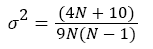
The Mann-Kendall slope allowed us to analyze the trend of time series by decade. In this analysis, the Mann-Kendall slope is defined by:
 (1)
(1)
Where n is the value of the meteorological parameter, N the number of the values ni and i = 1, 2,..., N
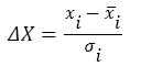
This size follows a normal distribution of zero mean and variance:
 (2)
(2)
Thus, if the slope τ is less than zero then the decay is significant, and the inverse confirms the growth.
The SPI is calculated from the monthly precipitation series for twotime steps and for each station.
The monthly average of the SPI is then calculated for each timescale.
 (3)
(3)
Where  is the annual total for station i,
 annual rainfall mean for station i,δ = standard deviation of annual totals for station i .
The SPI is an index for measuring meteorological drought. It is a probability index that relies only on precipitation. The probabilities are standardized so that an SPI of 0 indicates a medium amount of precipitation (relative to average reference climatology, calculated over 30 years). The index is negative for droughts, and positive for wet condition.
The calculation of the SPI requires the adjustment of long series of precipitation data to the Gamma distribution which is the distribution that best represents the evolution of the rainfall series. The estimation of the SPI is done by adjusting the distribution of the precipitation frequencies in each station to the Gamma distribution of the probability of the density. The values of the parameters of the Gamma function are estimated for each station and for each time scale (1 year, 60 years) and for each month of the year. The negative values of the SPI correspond to a dry year whereas, conversely, the positive values indicate wet years. Thus, we are faced with a phenomenon of drought when the values of the SPI become less than 0.99.
Results
The climate is thus constituted by a set of variables sufficiently stable in time so that one can both characterize different types of climates on the planet and compare the observed events with respect to the climatological norm.
According to our rainfall observations on the five stations of Chad, calculated at least 60 years are characterized by mean values, but also by variations and extremes.
Pluviometric variations: The statistical tests applied to the rainfall series show that interannual variations in rainfall at the Bongor, Bousso, Ndjamena, Moundou and Sarh stations are characterized by alternating wet, normal and dry years.
The result of the Pettitt test made it possible to identify ruptures in the rainfall series. The null hypothesis of absence of failure was rejected at the 99%, 95%, and 90% confidence thresholds. These breaks were identified in 1977 for the Bongor station and in 1971 for the Bousso station.
The identification of these years of ruptures makes it possible to distinguish two periods of fluctuations in rainfall over the Chari basin:
1. An overall wet period before 1977 in Bongor and 1971 in Bousso.
2. A dry period after these two dates.
Unlike rainfall, the flow series studied shows no major breaks. Indeed, the null hypothesis of absence of rupture is accepted for the three confidence thresholds.
The study carried out in the five stations through the evolution of the reduced centered indices, doubled by Hanning filtering, makes it possible to distinguish the periods of fluctuations of the annual modules from the following flow rates:
1. A 1959-1961 surplus period for the Bongor station, 1957-1959 for the Bousso station, 1962-1964 for Moundou, 1958-1960 for the station of Ndjamena and 1958-1961 for the Sarh rainfall station is marked by an abundance of flows, indicates a wet period;
2. A deficit period of 1982-1985; 1998-2008 for the Bongor station, 1982-1986; 1998-2000 for the station of Bousso, from 1982-2002 for the rainfall station of Moundou, from 1958-1974; 1979-1977 for the station of Ndjamena and of 1976-1995 for the station of Sarh which corresponds to a dry period marked by a great drop of the flows of the river in particular in the years 1982;
3. A 2009-2010 surplus period for the Bongor station announces a return of moisture at the end of the observation period.
Break period: By comparing the result of the Hubert segmentation, we realize that there are several ruptures in the pluviometric series. The stations in the Chari basin are marked by five breaks in Ndjamena in 1959, Sarh in 1975, Bongor in 1977, Bousso in 2005 and Moundou station in 2010. Sarh station has a break-up date identical to that given by the Pettitt and Lee and Heghnian test. These years of breakdown allow us to determine the impact of climate change on rainfall and its consequences on agriculture in the Chari Basin in Chad.
However, the results of the breaks calculated by the Pettitt, Lee and Heghnian tests and those of Hubert are set out in the Table 1.
| Stations | Observation period | Dates of Occurrences of Breaks | ||
|---|---|---|---|---|
| Pettitt’s Test | The Bayesian method of Lee and Heghinan | Hubert Segmentation | ||
| Bongor | 1950-2010 | 1977 | No Rupture | 1977 |
| Bousso | 1950-2010 | 1971 | 2005 | 2005 |
| Moundou | 1950-2010 | 1980 | 1951 | 2010 |
| Ndjamena | 1950-2010 | 1961 | 1961 | 1959 |
| Sarh | 1950-2010 | 1975 | 1975 | 1975 |
Table 1: Outbreak in the Chari Basin over the period 1950-2010.
Characteristics of climate change
In order to understand climate, weather conditions must be observed over long periods of time, so that extreme weather situations do not influence conclusions.
However, there are a number of key factors in measuring climate change:
Temperature and precipitation change: It is important to evaluate how climate has varied and changed in the past. The monthly mean historical rainfall and temperature data can be mapped to show the baseline climate and seasonality by month, for specific years, and for and temperature. The chart above shows mean historical monthly temperature and rainfall for Chad during the time period 1901-2015.
Temperatures and precipitation in Chad vary considerably and the effects of climate change on agricultural production are already visible. Since 1975, temperatures have increased by more than 0.8°C across much of Chad, with typical rates of warming greater than 0.2°C per decade [7].
The effects on agricultural yields vary greatly from region to region with rather positive effects at high and negative latitudes elsewhere.
Livestock and greenhouse gas emissions: Greenhouse gas emissions from human activities, particularly the increasing use of fossil fuels, are the leading cause of global climate change. In Chad, livestock, along with agriculture, is one of the main sources of greenhouse gas emissions. Ruminants emit methane during forage digestion and overgrazing, which decreases the carbon stored in biomass and soils, can be important sources of CO2 emissions. However, the importance of carbon emissions due to overgrazing is difficult to quantify: on the one hand, the biomass of Sahelian ecosystems is very dependent on climatic conditions, which masks the long-term effects of animals on the environment; on the other hand, it is often difficult to distinguish land-use change or livestock degradation from that caused by agriculture.
However, carbon storage in biomass and soils has the highest mitigation potential. Indeed, the potential for reducing methane emissions seems limited for livestock systems based almost exclusively on the exploitation of the country's important pasture resources. In return, the low rate of carbon fixation per hectare in tropical dry savannas is offset by the importance of the areas concerned.
Carbon sequestration in savannas depends on a good match between animal load and natural resources. Research shows that it is mainly the strong and continuous pressure of animals on forage resources that causes overgrazing. To promote the sustainable management of these savannas and the storage of carbon, it is, therefore, necessary to avoid the sedentarisation of pastoralists and, on the contrary, to favor the mobility of herds.
Land use
Change in land use is one of the socioeconomic drivers to worsen climate change impact on water resources.
Driven by an accelerated population growth and concomitant food demand, agricultural expansion is the main driver of the loss of Chad’s natural landscapes. Between 1975 and 2013, the annual rate of agricultural expansion was 5 percent, one of the highest in the region. This means that croplands almost tripled between 1975 and 2013, although this expansion is not uniformly distributed across the country. The spread of agriculture occurred mainly in the south, especially in the Bassin and Plaines du Logone (BLO and PRL – Basin and Plains of Logone), Collines du Mayo-Dala (CMD – Hills of Mayo- Dala), and Maro (MARO) ecoregions. Woodlands, mainly located in the south, have diminished by 29 percent between 1975 and 2013, amounting to a very significant loss of 4,700 sq km. The area of gallery forest also declined, but not as rapidly as woodlands. Their overall land surface was always relatively small, but it has decreased by 8.3 percent, a 400 sq km loss between 1975 and 2013.
Agricultural land: 39.6%; Arable land 3.9%; permanent crops 0%; permanent pasture 35.7%; Forest: 9.1%; Other: 51.3%
This entry contains the percentage shares of total land area for three different types of land use: arable land - land cultivated for crops like wheat, maize, and rice that are replanted after each harvest; permanent crops - land cultivated for crops like citrus, coffee, and rubber that are not replanted after each harvest; includes land under flowering shrubs, fruit trees, nut trees, and vines, but excludes land under trees grown for wood or timber; other - any land not arable or under permanent crops; includes permanent meadows and pastures, forests and woodlands, built-on areas, roads, barren land, etc. [8].
Effects of climate change on water resources in Chad
Climate change will affect water resources through its impact on the quantity, variability, timing, form, and intensity of precipitation [9].
Understanding the mechanisms and geographic models by which anthropogenic climate change affects the variability of water resources is crucial for sustainable development, environmental management, and human health. Effects of climate on the nation’s water storage capabilities and hydrologic functions will have significant implications for water management and planning as variability in natural processes increases. However, the availability of water and water is a major concern of the present study. The consequences of this rainfall variability on surface waters are evident in view of the importance of this resource, whose flow has ceased to be perennial in the dry season in some rivers such as Koumadougou Yobé, whose contribution to Lake Chad was Approximately 0.5 km3/year for the period 1990-2000 and the flow of Chari, the main source of water supply to the lake, was the lowest. The reduction of surface water in Chad (a loss of 60 percent of surface water between 1975 and 2013) is mainly a result of the receding area of Lake Chad. Over 38 years, the overall surface area of the lake reduced by 87 percent. This is a concern not only to Chad, but to the region. Rainfall shortages combined with heavy use of the lake and river waters to irrigate and a major population increase in catchment area account for this decline. The entire northern basin, which had water as recently as 1975, has completely dried out, replaced by steppes and herbaceous savanna. These changes in the country’s water resources have impacted its socio-economic life. If the situation did not return to normal, thanks to a succession of years of excess rainfall, other rivers could also see their flow stop in the years to come.
Because surface water supplies ground water, ground water has a double hydrodynamic consequence. The deepening of their roof reduces the potential of their replenishment by already reduced infiltration due to the decrease in rainfall and by the enormous evaporation of surface water due to the increase in soil temperature. Their faster drainage results in a reduction in low water flows and an increase in the rate of drying, which has led to a small flow of some large rivers feeding Lake Chad.
Effects of climate change on agriculture
Plant systems, and hence crop yields, are influenced by many environmental factors, and these factors, such as moisture and temperature, may act either synergistically or antagonistically with other factors in determining yields [10].
Lately, several Chadian farmers in the Chari Basin regret the fact that greenhouse gas emissions cause agricultural production to fall. In Chad, the agricultural sector is heavily dependent on weather conditions, with over 80 percent of cereals and 100 percent of cotton being rain fed crops.
Coverage of cereal requirements over the last ten years illustrates the country's food situation, which is characterized by cereal deficits every year. Cereal requirements are covered, on average, by only 79.3% of local production, with a maximum coverage rate of 94.9% in 1994 and a minimum rate of 62.5% in 2000. A Climate change scenario for SSA include an increase in seasonal and extreme temperature events and intensity of droughts as per IPCC in 2007 and are likely to result in changes in production and the suitability of current crops (Table 2) [11].
| Years | 1994-1995 | 1995-1996 | 1996-1997 | 1997-1998 | 1998-1999 | 1999-2000 | 2000-2001 | 2001-2002 | 2002-2003 | 2993-2004 | Average |
|---|---|---|---|---|---|---|---|---|---|---|---|
| Production available | 971470 | 773690 | 716760 | 793040 | 1065130 | 1003800 | 753040 | 1006710 | 976580 | 1154660 | 92149 |
| Needs | 1023470 | 1049060 | 1097610 | 1123520 | 1150000 | 1177240 | 1204900 | 1234640 | 1262440 | 1292240 | 116152 |
| Deficit | 52000 | 275370 | 380850 | 330480 | 84870 | 173440 | 451860 | 227930 | 285860 | 137580 | 24003 |
| Coverage | 94.90 | 73.75 | 65.30 | 70.60 | 92.60 | 85.20 | 62.50 | 81.60 | 77.35 | 89.35 | 79.3 |
Table 2: Coverage (%) of cereal requirements by local production over the last ten (10) years (Standard 159 kg/capita/year).
The Republic of Chad is confronted with extreme weather events which, depending on the season.
And, the bioclimatic zone can take the form of increasingly severe droughts or devastating floods.
Indeed, prolonged periods of extremely high temperatures in the Chari Basin in Chad have caused thermal stress in plants and lead to loss of yield. The problem is expected to be most severe in Africa where current information is the poorest, technological change has been the slowest, and the domestic economies depend on the most heavily on agriculture [12].
The RCC reports that in 2011, precipitation in the Sahel region of Chad was less than 50% compared to the previous year and rainfall irregularities caused a severe and reduced water deficit in the country as a whole planting levels at 43% in the Sahel region of Chad and 18% in the Sudanese region of the country compared to 2010. In this situation, pest attacks (locusts, caterpillars, birds, termites, etc.) contributed to the shortfall in harvests and harvestable areas. This deficit is very marked in the Sahelian region of Chad, where agricultural production has decreased by more than 56% compared to last year's production and the two areas of Kanem and Lac are particularly vulnerable in the region of the Sahel.
If agricultural production does not evolve over the next 10 years through the implementation of relevant support programs in this sector to encourage increased agricultural production and production at its current level of 921,490 tons (average of the last ten years), for a population of 10.6 million, the cereal deficit would be in the order of 764,000 tons and domestic production would not cover more than 55% of the Chadian population's needs, which would considerably increase the country's dependence on imports.
Silviculture: According to the FAO, Chad has 12. 692,000 ha of forests of which 14,000 ha are plantations and 12,678,000 ha are natural. These forests are subjected to intensive deforestation and are experiencing a decline everywhere, the various pressures they face do not allow them to play their ecological and biological role to guarantee the productivity of the soil which is constantly decreasing.
The dynamics of land productivity: Future demand for agricultural products will increase over the coming decades, driven by population growth and changing dietary habits [13], which means that agricultural production will have to increase but in Chad, the dynamics of land productivity depends on the condition of the vegetation cover; from north to south we have steppe and shrub savannah which provide very little biomass to the soil and therefore with very low soil productivity; in the center and in the Sudanian zone, with relatively high rainfall, the tree savannah allows the soil to acquire a higher land productivity.
Drought
Changes in rainfall patterns observed in the Sahel in the 1970s and 1980s have dramatically affected livelihoods in that region, which already had to cope with highly irregular and unpredictable rainfall patterns [14]. Decreases in rainfall have had profound repercussions on the flows of the main rivers that provide an essential source of livelihood for the population of arid areas. The land and especially the watershed were completely dry and the Sahelian strip of Chad is exposed to increasingly frequent droughts. Agriculture is extremely sensitive to climate change. Very high temperatures have decreased crop yields and have led to weed proliferation. Changing rainfall patterns increased the likelihood of short-term crop failure and a decline in long-term production.
However, a real food crisis has taken place in this area because the populations living in the Chari basin are entirely dependent on rainfall. For instance, individual families or communities may lose their livelihoods and source of water, subject to acute food shortages and health issues and the country’s economy may be severely impacted [15].
Agriculture and food security in chad
Climate change affects regions differently, but the poorest regions experience the worst impacts because they are very vulnerable [16]. The number of malnourished Africans has almost doubled since the late 1960s, increasing roughly at the same rate as population growth, a fact that indicates a lack of successful strategies in poverty alleviation and food security improvement [17]. Crop yields are declining and per capita, agricultural production declines as the population increased to double the demand for food. It is increasingly recognized that Chad's major challenge will be the fight against food insecurity.
The nutritional status of different socio-professional categories of the Chadian population is characterized by problems of quantitative coverage but above all qualitative of food needs. The cereal, which is the basis of food for almost all the Chadian population, contributes 50% to 80% of daily calorific intakes. This predominance of cereals may be at the origin of the results of the 1997 survey on nutritional status in Chad, which concluded on the low calorific availability per person per day. The average per capita intake is estimated at 1,720 calories per day, while the average is 2,160 calories in sub-Saharan Africa and 2,480 calories in developing countries as a whole as per EDST in 1997.
The 1997 data, EDST in 1997, analyzed as part of the Poverty Reduction Strategy, show that 40% of children under five suffer from chronic (underweight) malnutrition, the majority of which is in a form severe. The rate is higher for very poor households (46%) than for poorer households (34%). On the other hand, the infant mortality rate is much the same for poor and less poor households. The same is true for the juvenile mortality rate.
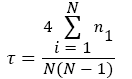
Projections of future climate
Temperature
1. The mean annual temperature is projected to increase by 1.0°C to 3.4°C by the 2060s, and 1.6°C to 5.4°C by the 2090s.
2. The range of projections by the 2090s under any one emissions scenario is 1.5°C to 2°C.
3. The projected rate of warming is similar in all seasons and regions of Chad.
4. All projections indicate substantial increases in the frequency of days and nights that are considered ‘hot’ in current climate.
5. Annually, projections indicate that ‘hot’ days will occur on 17‐36% of days by the 2060s, and 21‐54% of days by the 2090s.
6. Days considered ‘hot’ by current climate standards for their season are projected to increase most rapidly in JAS, occurring on 35‐84% of days of the season by the 2090s.
7. Nights that are considered ‘hot’ for the annual climate of 1970‐99 are projected to occur on 26‐49% of nights by the 2060s and 31‐63% of nights by the 2090s. Nights that are considered hot for each season by 1970‐99 standards are projected to increase most rapidly in JAS, occurring on 48‐95% of nights in every season by the 2090s.
8. Projected increases in hot days and nights are more rapid in the south of the country than the north.
9. All projections indicate decreases in the frequency of days and nights that are considered ‘cold’ in current climate, and in much of the country, do not occur at all by the 2090s (Figure 1).
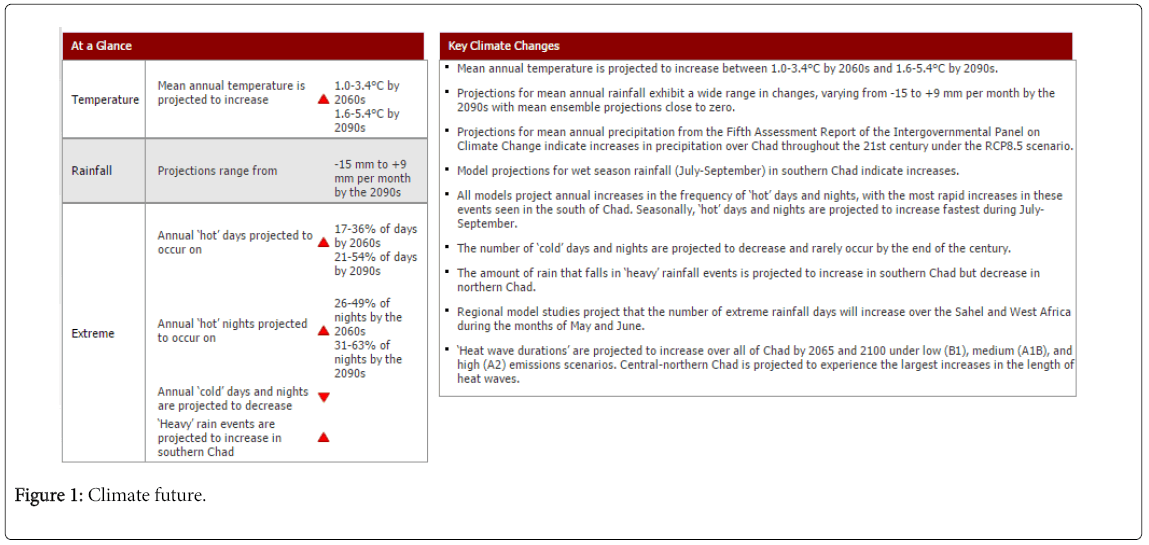
Figure 1: Climate future.
Precipitation
1. Projections of mean annual rainfall averaged over the country from different models in the ensemble project a wide range of changes in precipitation for Chad. Projected change range from ‐ 15 to +9 mm per month (‐28 to +29%) by the 2090s, with the ensemble means close to zero.
2. Whilst the range of projections across the model ensemble is large, the regional changes in rainfall more consistently indicate increases in wet‐season (JAS) rainfall in the south of the country.
3. The relative (%) changes in rainfall in the dry regions and seasons are exaggerated because of the very small rainfall totals that changes are presented as a proportion thereof (i.e. a 400% increase in JFM rainfall is equivalent to only an additional 5 mm).
4. The proportion of total rainfall that falls in heavy events is projected to increase in the south of the country, but to decrease in the north.
5. Projections indicate that maximum 1‐ and 5‐day rainfalls may increase in magnitude in the south of the country.
Discussion
The inter-annual variation of the rainfall determined by the rainfall indices coincides with the statistical tests. Indeed, the rainfall rupture in the study area is characterized by a decrease in rainfall. The analysis and interpretation of statistical data from Bongor, Bousso, Moundou, N'djamena and Sarh meteorological stations from 1950 to 2010 revealed rainfall variability and its impact on water resources in any form and surface water of Lake Chad country a heavy price. The southern regions of Chad experienced a sudden break in the rainfall series over the last decade, particularly in the 1982. Rainfall variability in Chad has been accompanied by a significant decrease in relative humidity and a rise in air temperatures, which has resulted in a hydrological cycle. It also manifested itself in the decline in rainfall, the reduction of rainy days, the extension of the dry season and the decline in the rainfall index.
Therefore, this rainfall variability influences the aquifers in terms of their water recharge and the feeding of Lake Chad. Indeed, since the rupture in the series of years 1982 the aquifers are experiencing real difficulties in the renewal of their water loads, creating a situation of water stress in Lake Chad and food crops. This rainfall rupture is the main cause of poor agricultural production. National cereal production does not cover the needs of the country. Grain availability, the average of the last ten (10) years, which is 921,490 tons, allows the Chadian population, estimated at 8.13 million in 2003, to have only 113 kg/year and per person, lower to 46 kg at the official cereal requirements for Chad, estimated at 159 kg/year. It is estimated that the remaining cereal requirements are met by commercial imports and food aid. Model simulations of precipitation changes for the Sahelian regions of Africa are strongly divergent and most models fail to reproduce realistic inter‐annual and inter‐decadal rainfall variability in the Sahel in 20th century simulations. Our understanding of the processes causing tropical rainfall is insufficient to allow a prediction of the direction of change with any certainty. The IPCC identify this as an area requiring further research to understand the variety of model responses in this region. But adaptation research undertaken now can help inform decisions by farmers, agrobusiness, and policy makers with implications over a range of timeframes from short-term tactical to long-term strategic [18]. However, it is particularly important to align the scales (spatial, temporal, and sectoral) and reliability of the information with the scale and nature of the decision. Moreover, adaptation was undertaken in a recent research project called “Adaptation Strategies for Climate Change in the Urban Environment (ASCCUE)” for strategic planning and urban design [19]. The goal of adaptation is defined as an adjustment that reduces the risk associated with climate change, or the vulnerability to climate change impacts, to a predetermined level without compromising economic, social, and environmental sustainability [20]. This study develops a framework for adopting the technological progress (improvement of agricultural yields in arid and semi-arid conditions), irrigation (water management at the agricultural plot of the Chari watershed) and land use according to their agricultural vocation.
Conclusion
Water is an essential production factor in agriculture for both crop production and livestock production. Climate change is already having a significant impact on Chadian agriculture in terms of quantity and quality of water, floods, storms, and droughts.
The agricultural sector plays an important role in the economy of the country, but its share in the state budget is still low. The country must begin to allocate more resources to agriculture. An effort must be made to ensure that the share of the State budget allocated to agriculture should not be less than 10%. Cereal production is highly unpredictable due to weather conditions and can fluctuate considerably from one year to the next even if rainfall is good or bad. Thus, average available production over the last ten (10) years is 921,460 tons, whereas in 1996, the year of drought, it was only 716,760 tons, compared to 1,154,660 tons in 2003, the year good rainfall. An increase in these effects makes it almost impossible to adapt adequately by the agricultural sectors in many places and lead to drastic declines in productivity.
The impacts of climate variability and change on Chadian ecosystems are unequivocal. The sectors most affected are agriculture through land degradation, declining crop productivity, livestock and water resources. Impacts on these sectors have negative consequences on the populations because they are more than 80% rural.
Indeed, rising temperatures and rainfall variability represent a serious threat to global agricultural development, particularly in the Sahel countries, and could jeopardize countries' efforts to achieve food security. Rising temperatures combined with increased rainfall variability will lead to dysfunctions in agricultural seasons, disruptions in crop biological cycles and deterioration in agricultural production. Simulations carried out in tropical zones using agrometeorological models make it possible to analyze the response of crops to the rise in temperature. Agricultural production, livestock farming, and fishing all rely heavily on freshwater resources in Chad and the need for better management of these resources is necessary for the future. Climate change will aggravate the human pressure already on these systems and better management is needed to ensure Chadians have access to freshwater resources.
References
- Upadhyaya A (2016) Integrated water resources management and climate: Change adaptation strategies. Irrigat Drainage Sys Eng 5:176
- Sathaporn M (2014) Climate change impact on water resources in agricultural and adaptation: A case study of kanchanaburi province, Thailand 141-145
- Ludi E, Christopher S, Peskett L, LÃdia C (2007) Climate change and agriculture: Agricultural trade, markets, and investment
- Oteze, GE, Fayose (1988) Regional development in the hydrogeology of chad Basin. p: 9.
- Cratchley CR, Louis P, Ajakaiye DE (1983) Geophysical and geological evidence for the Benue-Chad Basin Cretaceous rift valley system and its tectonic implications. Journal of African Earth Sciences 2: 141-150
- Yusuf AK, Goni IB, Hassan M (2014) Hydro chemical studies of the groundwater resources of the middle zone aquifer in the Southwestern Chad Basin 62.
- Williams AP, Funk C (2011) A westward extension of the warm pool leads to a westward extension of the Walker circulation, drying eastern Africa. Climate Dynamics37: 11-12
- https://www.cia.gov/library/publications/the-world-factbook/fields/2097.html
- Adams RM, Peck DE (2008) Effects of climate change on water resources.p: 12.
- Adams RM, Hurd BH, Lenhart S, Leary N (1998) Effects of global climate change on agriculture an interpretative review. Climate Research 11: 19-30
- Cairns JE, Hellin J (2013) Adapting maize production to climate change in sub-Saharan Africa. Food Sec 5: 345
- Mendelsohn R (2000) Climate change impacts on African agriculture. Preliminary analysis prepared for the World Bank, Washington, District of Columbia 12: 25
- Dietricha JP, Schmitz C (2012) Measuring agricultural land-use intensity – A global analysis using a model-assisted approach.Ecological Modelling 232: 109-118
- Diallo HA (2005) Drought is the silent killer - The natural catastrophe that is only too easily forgotten. p: 43.
- Maskey MS, Mussá FE, Trambauer P (2014) A review of droughts on the African continent: A geospatial and long-term perspective.Hydrology and Earth System Sciences 18: 3635
- Gender and Climate Change Capacity development series (2012) Africa Training module 4, agriculture and food security.p: 6.
- Kidane W, Maetz M, Dardel P (2006) Food security and agricultural development in sub-Saharan Africa
- Walsh CL, Hall JW, Street RB (2012) Building knowledge for a changing climate: Collaborative Research to understand and adapt to the impacts of climate change on infrastructure. The built environment and utilities 31
- Doria M, Boyd E, Tompkins E, Adger WN (2009) Using expert elicitation to define successful adaptation to climate change. Environmental Science and Policy 12: 810-819
Citation: Bantin AB, Jun X, Si H (2017) The Impact of Climate Change on Water Resource of Agricultural Landscape and its Adaptation Strategies: A Case Study of Chari Basin, Chad. J Earth Sci Clim Change 8: 437. DOI: 10.4172/2157-7617.1000437
Copyright: ©2017 Bantin AB, et al. This is an open-access article distributed under the terms of the Creative Commons Attribution License, which permits unrestricteduse, distribution, and reproduction in any medium, provided the original author and source are credited.
Select your language of interest to view the total content in your interested language
Share This Article
Recommended Journals
Open Access Journals
Article Tools
Article Usage
- Total views: 7112
- [From(publication date): 0-2017 - Dec 09, 2025]
- Breakdown by view type
- HTML page views: 6097
- PDF downloads: 1015