The Landslide Lake of Jaydar
Received: 29-Jan-2019 / Accepted Date: 19-Feb-2019 / Published Date: 26-Feb-2019
Abstract
The Seymareh rock avalanche is in South of Pol-Dokhtar Township between Lorestan and Ilam provinces in SW of Iran. It is known as the largest rock avalanche in the world, and has created a lot of changes in morphology, hydrology and hydrogeology conditions in the N and NE Kabir Kuh Mountain. The creation of 3 landslide dams and its relative lakes include Jaydar in the North, Seymareh in the West and Gori Balmak in the East. The Jaydar dam is the largest of these dams. The Jaydar dam with the width, length and the height 2000, 11000 and 80 m, respectively was created on the Kashkan River and creates a lake with a length of 36 Km which is called Jaydar Lake. A sedimentary zone with an area of 65 Km2 with over consolidated and freshwater soils shows the extent of the lake. After an unknown time, Jaydar lake is drained by a natural spillway in this study based on field observation, the use of GPR, field and laboratory tests will be determined characteristics of engineering geology of dam and lake sediments of Jaydar, as well as the morphology of the area before the landslide. GPR results show that material deposited in the region have a thickness of more than 70 m that reaching to even 100 m. The results showed that the sediments in the region are often over consolidated fine grained includes low plasticity Clay (LL<30) and Clayey Sand (LL<25). The main part of the coarse grain is a GW-SW lens with cu=35, cc=1.6 and k=0.19 m/s with a thickness of less than 30 meters and depth of more than 20 m, which created a confined leakage aquifer. The results of the Crumb, double hydrometer and chemical tests showed that in study area CL and SC Soils has high potential dispersion. Studies show that the bedrock of lake sediments is evaporates rocks (Gachsaran Formation) with joint set that filled by high dispersion soils. So, expect fresh water lake sediment of landslide dams will have the potential geotechnical problems such as dispersion, piping, collapse and land subsidence
Keywords: Seymareh rock avalanche; Landslide dam; Jaydar lake; Dispersion; Piping; Pol-Dokhtar; Gully erosion
Introduction
The damming of major rivers calamitous landslide is an important geological hazard and a considerable geomorphic process in mountain areas [1-3]. River damming mostly outcome in extralarge impoundments that, in some historical cases, the volume of the reservoir of dam is larger than reservoirs made by humans [4]. These are necessary for create landslide dams conditions, such as height, slope and discontinuities (layering, fault and joint), and triggers factors (rainfall, melting and earthquake) [5]. The failure of a landslide dam causes disastrous downstream floods, in addition to mortal and financial losses, and the destruction of houses and infrastructure, For example, the failure of the Raikhot Landslide Dam with a height of 200- 300 m and a lake with a length of >65 Km on the river Indus of Pakistan country destroyed more than 1800 houses. Landslide dams, which are both complex and composite, are notable geomorphic forms due to their impermanent existence in foreside of impoundment lakes [5]. The distribution of the particle size of the dam body is very effective in the resistance of the dam to the erosion and piping process [6-8]. In April 2000, due to a large rock sliding a large landslide dam was created on the Path of Yangon ZangPo River on the Tibetan plateau. This dam was ruptured after 62 days, causing a large flood with a height of 5.5 m. In addition to the Tibet area, the flood also affected the distance of 500 Km to the Brahmaputra Plain in NE India [9]. In 2008 rupture of the Tang Jinshan landslide dam was studied using various experimental models of prediction and how the dam was damaged by reservoir filling. In all models, the main parameters at the time of dam failure were assumed to be the thickness and composition of the dam materials [10]. The Turtum landslide with age more than 1600 BC, located in 90 Km north of Erzurum, Turkey. This landslide has formed as one of the largest landslide-dammed lakes in Turkey with a length and width of 8500 m and 2500 m, respectively and a surficial area of 77.6 Km2. The volume of displaced mass and the landslide dam is estimated to be 223 and 180 Million m3 [11]. With the analysis of 300 landslide dams in Italy, some geomorphological indexes, such as volume of landslide dams and some hydro morphological indexes, such as the stability of the dam and river energy, have been estimated [12]. There are more than 24 landslide dams in Iran including 19 permanents and 5 temporaries [13]. Three landslide dams caused by the Seymareh rock avalanches are the most reported in Iran, that Jaydar dam is largest of these dams. The geology studies specially engineering geology can identify some ambiguities, such as the formation and failure of landslide dams, as well as some geotechnical problems and hazards in the study area. In this study, the effects of forming of the Jaydar landslide dam on morphology and changes in hydrology and hydrogeology of the region are investigated. Engineering geology properties remaining sediments of activity Jaydar Lake was investigated. Undoubtedly, the engineering behavior of heterogeneous deposits with in-situ geological units plays an important role in development programs in region.
History researches Seymareh Rock Avalanche
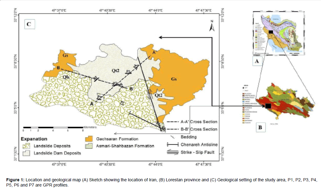
The seymareh rock avalanche with volume of its debris about 44000 Million m3 is the largest known subaerial and non-volcanic landslide on Earth. It seems that the initial failure in the Kabir Kuh is wedge shaped in the Asmari Formation along the shear joints, followed by the main of the sheet sliding before rupturing in the shape of a wedge in the Pabdeh – Gurpi Formation. It has been suggested that an earthquake a magnitude of greater than 7 on the Richter scale, probably related to the Kabir Kuh fault has been the main cause of the seymareh rock avalanche [14,15]. Accordingly, a part of the layers of the Asmari Formation has been slipped over the NE Kabir Kuh Mountain along more than 15 Km and average thickness of 350 m. The detached material has moved from its original location to a distance of 20 Km and has covered a surface of more than 166 Km2 (Figure 1). As a result of this event, three natural lakes have been formed in the NE and west of the landslide edge. The age of sediments of these lakes is determined using radiocarbon 14 equivalents to 10037 ± 120 years [16-22]. These landslide dams are one of the most important geomorphological changes due to the event of Seymareh rock avalanche [23]. Two permanent rivers, including the Kashkan River from the North and the Seymareh River from the West run through Pol-Dokhtar area. The Karkheh River is formed from the connection of these rivers in the SW of Pol-Dokhtar city. The landslide dams the Jaydar and the Seymareh have been created along these rivers after the occurrence of the Seymareh rock avalanche, Also There is a smaller landslide dam called the Gori Balmak in east area [19]. Performing field research analysis and use of geological and topographic maps and software ARC GIS, the area of Jaydar Lake was estimated to be 2 times more than the area provided in the current maps. Also, according to the thermoluminescence dating method, the time of the formation of the lake is 15,000 years old, the lake's lifetime is 80,000 years ago, which was disrupted 5,000 years ago [24]. Sampling of lake sediments (60 samples) from 7 parts in the area of Jaydar, Seymareh and Gori Balmak lakes, and gradation test (wet and ultrasonic methods) showed that Seymareh landslide occurred in two-stage [25]. The reason for the failure of Jaydar and Seymareh landslide dams can be the hydromorphology of the area, the junction of the two Lakes (Jaydar and Seymareh), the high discharge of the rivers supplying lakes dam, the high erosion of energy in the area and an external stress, such as earthquake [26]. Geometric indexes of Kabir Kouh landslide including dimensions (length, width and thickness) were determined using DEM and a 1/50000 scale topographic maps, indicating a width and length of rupture 16.6 and 15.5 Km, respectively, the average thickness of more than 300 m and the volume of landslide materials of 3908200970 m3 [27]. Effective and well-known factors are the creation of Seymareh rock avalanche, the presence of discontinuity systems, the amount of dip of the bedding plane, the parallelism of the layering surface and the surface of the earth, the differences in the physical and mechanical indexes of rock units, groundwater and quick stresses such as earthquakes. Also, the Seymareh Rock avalanche been studied by Demorgan, Schuster and Costa, Schmidt et al., Maleki and Bahrololoomi, Schuster, Vahdati and Yamani et al.
General characteristics of the area
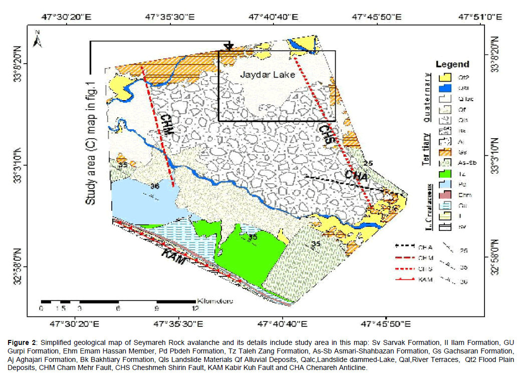
The study area is located in the south of Lorestan Province at latitude of 47°37´ to 49°39´ N and longitude 33° 05´ to 33°09´ E in South-West of Iran (Figure 1). The average height of the area is 683 m.a.s.l. The annual average precipitation and annual evapotranspiration are 360 and 2920 mm, respectively and the climate of the study area is semi-arid. The area has very warm summers (Maximum daily July temperature 47°C) and cold winters (Min. daily January 0°C). The main drainage system of the region is the Kashkan River and its average discharge in the region is 53 m3/s. The lithological units exposed in the NE flank of Kabir Kuh anticline from the late cretaceous the Sarvak formation to the Lower Miocene the Gachsaran formation. The Asmari- Shabazan (As-Sb) formation (Oligocene-Lower Miocene) has the most outcrops among all geological units in the NE Kabir Kuh range. On the other hand, quaternary sedimentary units in the area include landslide materials and lake deposits of landslide dams (Figure 2). In the Jaydar plain, Gachsaran Formation is the bedrock of Quaternary sediments.
Figure 2: Simplified geological map of Seymareh Rock avalanche and its details include study area in this map: Sv Sarvak Formation, II Ilam Formation, GU Gurpi Formation, Ehm Emam Hassan Member, Pd Pbdeh Formation, Tz Taleh Zang Formation, As-Sb Asmari-Shahbazan Formation, Gs Gachsaran Formation, Aj Aghajari Formation, Bk Bakhtiary Formation, Qls Landslide Materials Qf Alluvial Deposits, Qalc,Landslide dammed-Lake, Qal,River Terraces, Qt2 Flood Plain Deposits, CHM Cham Mehr Fault, CHS Cheshmeh Shirin Fault, KAM Kabir Kuh Fault and CHA Chenareh Anticline.
Research Methodology
In order to accurately assess the area, we have created the DEM of area with using IRS-P5 satellite imagery and ENVI software for study the morphology and geometry of the dam, the lake and its lateral spillway, also provides cross-sectional and longitudinal sections of geology. Ground penetration radar (GPR), method is used to identify the status of bedrock, geological structures and dissolution cavities in the rock mass, as well as the thickness and the vertical and lateral changes of the lake sediments and identity of the old morphology of location before the creation of Jaydar Lake. The data of piezometer, wells and springs have been used to identify the hydrology and hydrogeological conditions. Engineering geological characteristics lake sediments are determined by field and laboratory tests. In this paper all of maps and cross sections are drawn by Arc- GIS and AutoCAD software.
The Jaydar landslide dam and related lake
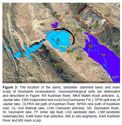
The Jaydar landslide dam has been created because of the blockage of the Kashkan River after sliding occurrence in Kabir kuh. This dam was created at a distance at 8 Km southwest of the Pol-Dokhtar city. This horseshoe dam has a length of 11 Km, width of 2 Km and an average height of 140 m from the bedrock. The highest part of the dam at a height of more than 220 m is located at the end of the Chenareh anticline. The main part of the framework of the dam is formed of large blocks of the Asmari limestone. Therefore, this dam is place in stable dam’s classes. After the formation of the landslide dam a lake is formed with a length of 36 Km and surface area of 65 Km2 on Kashkan River. The total volume of the reservoir is more than 3860 million m3. The main part of the reservoir is located on Jaydar plain. This plain is an ellipsoidal section with surface area of 46.8 Km2 (Figure 3). The slope of the plain in the SW - NE and NW – SE is 3.1 and 2.3 percent, respectively. The Maximum and Minimum height of the plain are 697 and 654 m.a.s.l. The dimensions of the landslide dam and related lake showing in Table 1.
Figure 3: The location of the dams, landslide- dammed lakes and main scarp of Seymareh rockavalanch. Geomorphological units are delineated and described in Figure: KR Kashkan River, MKA Maleh Kouh anticline, JL Jaydar lake, EBR evaporates bed rock(Gs)(Gachsaran Fm.), SPW spill way of Jaydar lake, OLPKR old path of Kashkan River, NPKR new path of Kashkan river, GL Gori Balmak lake, CHA Chenareh anticline, SR, Seymareh River, SL Seymareh lake, FF strike slip fault, LSD landslide dam, LSM landslide materials(Qls), KAM Kabir Kuh anticline, INS in situ segments, KAR Karkheh River and MS main scarp.
| Dimensions | Value |
|---|---|
| Length of dam | 11000 m |
| Width of dam | 2000 m |
| Height of dam from the spillway bottom | 80 m |
| Height of dam from the bed rock | 140 m |
| Length of the dam lake | 36000 m |
| Height of dam m.a.s.l | 821 m |
| Volume of the dam reservoir | 3860 mm3 |
| Area of the dam lake | 65 km2 |
| Catchment area | 9175 km2 |
| *All the dimensions are approximate. | |
Table 1: Dimensions of the landslide dam and its vicinity.
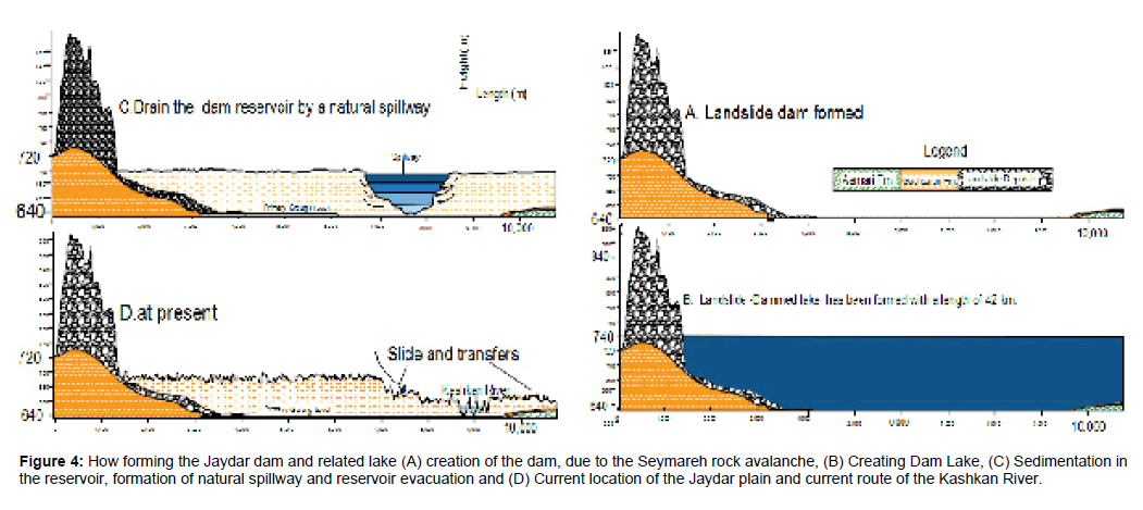
In general, the formation of the Jaydar dam and drainage of its reservoir have been carried out in 4 steps following: For the first stage, the creation of new geomorphological changes in the region due to the occurrence of Seymareh rock avalanche, the most notable changes are the increase in elevation from 640 to over 880 m. New heights have created a crescent dike with a length of more than 10 Km, which is called the Jaydar dam (Figure 4A). In the second stage, due to the blockade of the path of Kashkan River, a lake has been created with an area of more than 65 Km2 (Figure 4B). The lake is filled up to a maximum of 740 m.a.s.l (Figure 4B). In the third stage, due to the topography slope in the northwest part of the plain, the reservoir water at a height of 740 m was drained by a natural spillway (Figure 4C). Finally, in the fourth stage, the current plain has been created, with an average elevation of 700 m.a.s.l which eroded in some places and created badland morphology (Figure 4D).
Figure 4: How forming the Jaydar dam and related lake (A) creation of the dam, due to the Seymareh rock avalanche, (B) Creating Dam Lake, (C) Sedimentation in the reservoir, formation of natural spillway and reservoir evacuation and (D) Current location of the Jaydar plain and current route of the Kashkan River.
Solubility bedrock and increased discharge from the channel during floods, causes a diversion channel with longitudinal and transverse cross-section S-shape and V-shaped respectively. The cross-section of this channel varies from 12900 m2 in the Jaydar dam location, up to 67500 m2 at the entrance to the reservoir of the Seymareh Dam. The channel length is 12.5 Km and has a 19% longitudinal gradient. The maximum and minimum depth of this channel is 160 and 45 m, respectively. Now this channel, the new route of the Kashkan River after the occurrence of the Seymareh rock avalanche.
The sub surface geological properties of study area
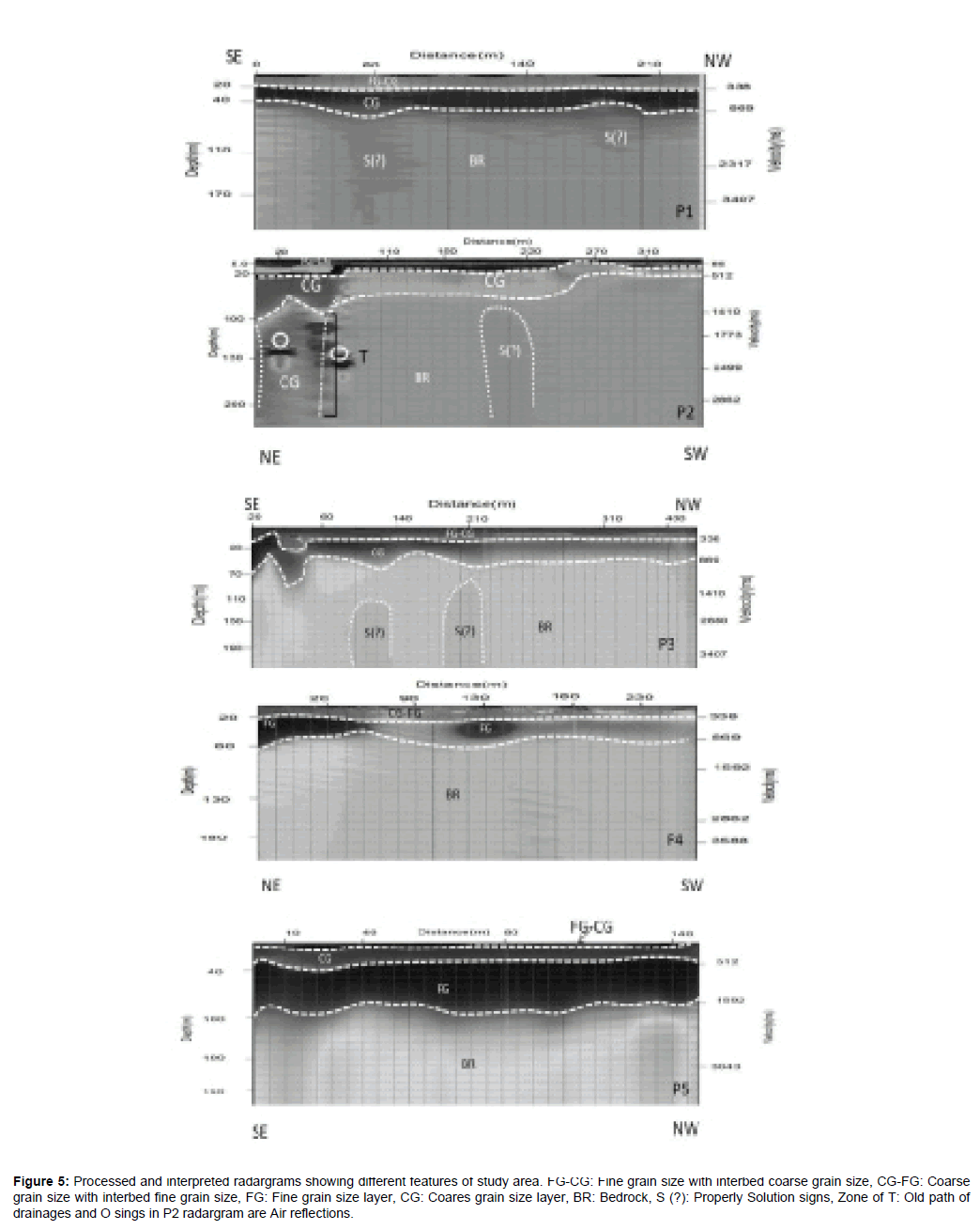
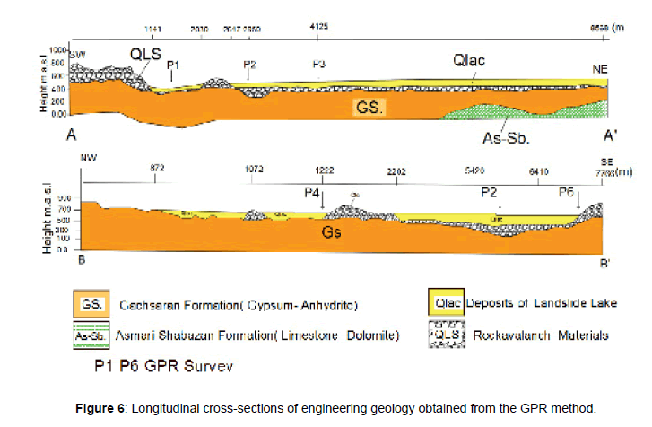
We have use geophysical process in order to determine conditions of sedimentary sequences, bed rock status, as well as determine of the buried deranges paths. For this purpose, The GPR equipment consists of a Loza II control unit, an odometer, a 6-meter connection cable and two antennae, at 10 MHZ was used to extract a longitudinal profile in the Jaydar Plain and a part of landslide materials with a length of 1965 m includes 7 GPR profiles P1, P2, P3, P4, P5, P6 (For field correlation) and P7 (Figure 5) The study of radargrams shows that in the study area there are 3 to 5 fine and coarse grains sedimentary layers with a thickness of 70 m to more than 100 m on bedrock. We have obtained the longitudinal profiles AA΄ and BB́ using the results of GPR and field studies in the direction of NE-SW and NW-SE (Figure 6). The cross-section AA’ has a length of 8568 m in the NE-SW direction, which, by cutting off P2, passes NW of P3 and P4 profiles. The first part of this section, with a length of 1141 m, is located on the rock avalanche materials. In the P2 location, sliding materials are covered by gentle slopes of the lake sediments. At P2, the thickness of the sliding material is over 100 m. It seems that at this point there is an old and buried valley. The lake sediments with a thickness of more than 70 m are seen from 1141 to 2030 m. Due to the low depth of the bedrock, from 2.030 to 2.617 Km and 587 m in length, sliding materials are exposed on the ground. From 2617 to 8568 m, lake sediments with a thickness of 60 m have been extended again. Sliding materials are seen beneath of the lake sediments during AA´ cross section, which decreases its thickness to the North. The BB´ cross section has a length of 7766 m in the NW-SE direction. This cross section interrupted P5, P2 and P6 profiles. The first section of this cross section is 872 m long, located on the Gachsaran Formation. Then the lake sediments of 200 m long and 10 m thick thickness are seen. Also from 1072 to 2202 m AA´ cross section due to the low depth of the bedrock, sliding materials are exposed on the ground. Along a large part of this cross section with a length of more than 4 Km, extensive sediments of the lake with a thickness of more than 70 m exist. The bedrock is also located at the radargram P2 at a depth of more than 120 m. On the whole, it can be said that the sediments of Jaydar plain are of uniformity and the particle size. In a number of radargrams, old terraces are found (for example west of Sarab Hamam village in south of Jaydar plain) on the boundary of bedrock and sliding materials which are most likely due to the operation of the Kashkan River in this area. it seems that the old route of the Kashkan River can be passed from the South of Jaydar plain.
Figure 5: Processed and interpreted radargrams showing different features of study area. FG-CG: Fine grain size with interbed coarse grain size, CG-FG: Coarse grain size with interbed fine grain size, FG: Fine grain size layer, CG: Coares grain size layer, BR: Bedrock, S (?): Properly Solution signs, Zone of T: Old path of drainages and O sings in P2 radargram are Air reflections.
Status of bed rock
The combination of GPR results and field surveys showed that study area in terms of morphology is a part of Cham- Mehr Syncline. In this location The Gachsaran Formation is the youngest lithological unit. Therefore, the Gachsaran Formation with lithology gypsum, anhydrite and marl is the bedrock of lake sediments. High solubility (Kc=0.228 × 10⁻⁵ m/s) is the most important feature of Gachsaran Formation as the bedrock of study area. This factor, together with tectonic structures and hydraulic gradient of groundwater has created karst caves, sinkholes and vertical galleries (Figure 7).
Accordingly, the mean depth of the bed rock has been over 70 m, but in some points, due to initial morphology, the depth reaches over 100 m. One of the important characteristics in bed rock is Karstification phenomenon. One of the most important influential factors in Karst phenomenon in bed rock is high hydraulic slope. The depth of Karstification in bed rock reaches over 100 m. It seems that this place could be part of the old path and buried river before Seymareh rock avalanche, which blocked by the sliding materials.
Buried drainage paths
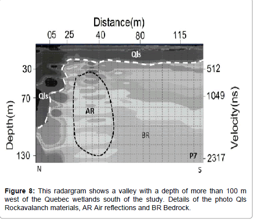
The results obtained from measuring the water table level using the piezometers available in the region indicate that the water table level of groundwater declines from SE to NW. For more accurate assessment of these changes a GPR profile with a length of 133 m in the proximity of the wetlands located in SE of Mirabad Village was extracted (Figure 8). Based on the prepared radargrams, it is observed that in this path, the volume of aggregation of landslide materials continues up to a mean depth of 100 m below the ground level. Over-aggregation of materials in comparison with other regions suggests geomorphological downhill in this region. This valley is also seen at the GPR profile P2. Based on the geophysical studies at this point, it seems that this place can be a part of old and buried path of Kashan River that blockage by landslide materials after the Seymareh rock avalanche. Aquifer in this region can be fed by subsurface streams.
Hydrogeology
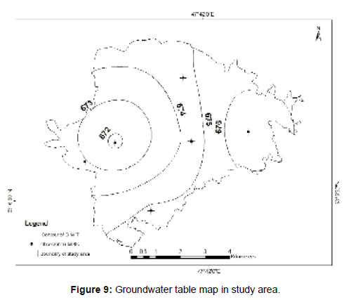
To determine the hydrodynamic pattern of the region, we divided it into two sections including the area between Pol-Dokhtar City and the Jolgueh Khalaj Village as well as the Jaydar Plain. The presence of Karst Springs including the Malavi Spring with discharge about 40 lit/s and at 730 m.a.s.l. as well as the contact springs around the two sides of the Kashkan River between the Jolgeh Khalaj Village and Pol-Dokhtar City indicates that, hydrodynamically, this valley feeds the river’s groundwater. However, the hydrodynamic status in the Jaydar Plain is bilateral, in which this plain is fed by rock avalanche materials and its feeds the Kashkan River. This can be due to common impermeable bed rock (Evaporates rocks), slide materials of Jaydar Plain, and hydraulic gradient of the region. In the region, according to the data of 5 wells piezometric (Table 2) groundwater level is approximately 20 m. Also, the groundwater level curves map shows the direction of water flow from East to West (Figure 9).
| Piezometer code | Coordinates | Piezometer height (m.a.s.l) | G.W.T (m) | |
|---|---|---|---|---|
| λ | Փ | |||
| 1 | 47°41΄01̋ | 33°07΄35̋ | 673 | 14 |
| 2 | 47°39΄02̋ | 33°07΄33 ̋ | 668 | 22 |
| 3 | 4741΄21 ̋ | 33°09΄00̋ | 675 | 25 |
| 4 | 47°40΄20 ̋ | 33°06΄53 ̋ | 677 | 20 |
| 5 | 47°43΄55 ̋ | 33°07΄39 ̋ | 680 | 24 |
Table 2: Characteristics of piezometer in study area.
Engineering geology properties
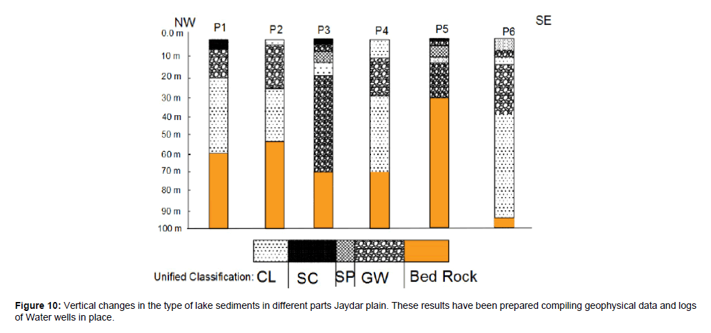
The sediments remained from the Jaydar landslide dam have geotechnical properties of fresh water lakes sediments. Among these properties are concentration of sand coarse-grained particles in the coasts, placement of fine-grained silt and clay sediments on the lake’s bottom, layered form of clays and their little resistance, the frequency of evaporative minerals, and dispersion potential. At the time of filling the dam's reservoir, the average water level in reservoir the dam was more than 60 m (Figure 6B). So, based on historical geology Can be said that current deposits remained at the lake dam Jaydar be over consolidated. In this study, engineering geological characteristics of the lake sediments and its bedrock have been determined using field and laboratory tests. According to the unified method, the soil physical properties have been determined by graining, hydrometer and Atterberg limits tests. Also, some of the mechanical field properties of the sediment including the Vane shear test (VST) and unconfined undrained (UU) test are determined. Also, dispersion of potential of filled material of Joints bedrock was determined by double hydrometric, Crumb method and chemical tests. Results of field and laboratory tests show in Figure 9 and Table 3. In order to determine the engineering geological characteristics of lake sediment, it has been prepared from 6 locations, 18 samples in the form of disturbed and undisturbed soil (Table 3). The quaternary deposits in Jaydar plain are composed of lacustrine sediments include light gray clay with lenses light brown sand and gravel (Figure 10). Based on GPR results thickness of deposits various from 40 m to 100 m. According to the unified classification, the soils of study area are fallen in to categories of CL, SW, SP, SC and GW. The most important properties of these soils are shown in the Table 4. The coarse layer has a thickness of less than 30 m between the finegrained CL layers with a thickness of more than 40 m. This layer with a permeability of more than 0.19 cm/s can be considered as the main aquifer of the area.
| Location | Coordinate | Depth of Sampling | Type of Sample | Number of Sample | ||
|---|---|---|---|---|---|---|
| λ | Փ | |||||
| Disturbed | Undisturbed | |||||
| Road trench | 47°48΄48 ̋ | 33°15΄45 ̋ | 9 | * | 2 | |
| Gully | 47°39΄42 ̋ | 33°07΄09 ̋ | 7 | * | 2 | |
| River valley | 47°44΄54̋ | 33°13΄18 ̋ | 20 | * | * | 6 |
| Test pit | 47°39΄54 ̋ | 33°06΄50 ̋ | 3 | * | 2 | |
| Road trench | 47°44΄54̋ | 33°13΄18 ̋ | 10 | * | * | 4 |
| Channel trench | 47°39΄29 ̋ | 33°07΄56 ̋ | 2 | * | 2 | |
Table 3: Location of sampling of lake sediments in study area.
| Materials | USGS Class | Atterberg limits test | penetrometer | Shear residual | VST | Grading test | ||||||||
|---|---|---|---|---|---|---|---|---|---|---|---|---|---|---|
| gd | LL | PL | PI | Li | Ci | UU | Cu | ø | C(Kpa.) | Cc | CU | |||
| Lake Sediments | SW | 2.15 | 49 | 0.2 | V | 1.09 | 7.86 | |||||||
| SP | 2.18 | 44.5 | 0.35 | 0.826 | 4.34 | |||||||||
| SC | 2.17 | 24.4 | 16.7 | 7.7 | 2.55 | 1.18 | ||||||||
| GW | 2.7 | 49 | 0 | 1.6 | 35 | |||||||||
| CL | 1.67 | 29.7 | 11 | 18.7 | 0.35 | 0.54 | ||||||||
Table 4: Physical and mechanical characteristics of lake deposits in study area.
The geotechnical problems
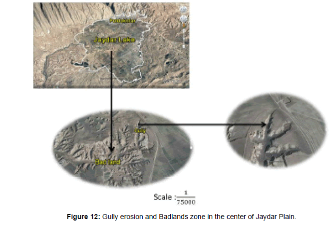
The lake sediments of the Jaydar Dam have special geotechnical properties including susceptibility for solubility, internal erosion (Piping), and dispersion of clay and silty clay layers. The surface water, especially water from irrigation agriculture, influential in parts of coarse-grained surface, causing internal erosion (Piping) of silt and formation holes at 1 cm (Figure 11C) which increases their dimensions with over time and forms tunnel- shaped holes (Figure 11D). Continuation of the trend of internal erosion in the fine-grained parts causes development of false caves. Entrance of current water to these holes, low tensile strength of the roof of holes and its collapse causes V-shaped depressions on the ground. These points are a suitable site for the flow of surface waters. This process is initiation of development of Gully erosion in the region. In the studied region, gully erosion has caused development of badland regions in two points of the central and NE part of Jaydar Plain. The trend of development of badland regions severely threatened the Buildings in Jaydar plain such as oil and gas pipelines, major roads, urban and rural residential areas, and agricultural lands (Figure 12).
In the catchment of the Jaydar landslide dam, the surface area of units with evaporate rocks is 2058 Km2, accounting for 12.8% of the catchment area. The predominant origin of existing salt minerals is related to the Gachsaran evaporative formation with the age of middle Miocene. The results of the chemical tests indicate that concentration of sulfate ion in the form of CaSO4, 2H2O in Jaydar Lake is from 3% in the Jolgeh Khalaj to 18.4% in Jaydar Plain and this factor causes solubility of sediments in the region. Further, dispersion is another geotechnical property of lake sediments of Jaydar Plain.
In order to determine the dispersion of soils in the region, 10 soil samples were selected from different parts of the region, Then the dispersion soil have been estimated using three methods Crumb, Double hydrometer and chemical methods [28]. The results of the experiments showed that CL and SC soils have high degree of dispersion (Table 5). Due to the large spread of fine-grained soils, some geotechnical hazards are expected in the region.
| Number of samples | Sampling location | (meq/l)Avg. cations | PH | SAR | EC | PS | Dispersion degree | |||||||
|---|---|---|---|---|---|---|---|---|---|---|---|---|---|---|
| Na+ | K+ | Ca 2+ | Mg 2+ | TDS | Sherard | Crump | Double hygrometer | |||||||
| 2 | Jolgeh Khalag Village | 0.31 | 0.21 | 2.80 | 1.20 | 4.52 | 7.5 | 0.22 | 0.33 | 6.86 | Not dispersion | Dispersion | Dispersion | |
| 2 | Trench of road | 0.21 | 0.11 | 3.10 | 1.80 | 5.22 | 7.80 | 0.13 | 0.41 | 4.02 | Not dispersion | Not dispersion | Dispersion | |
| 2 | Trench of road | 0.22 | 0.18 | 3.20 | 2.10 | 5.70 | 7.60 | 0.14 | 0.39 | 3.86 | Not dispersion | Not dispersion | Dispersion | |
| 2 | Gol Gol Village | 2 .65 | 0.15 | 0.85 | 1.10 | 4.75 | 7.9 | 2.68 | 0.41 | 55.79 | Dispersion | Dispersion | Dispersion | |
| 2 | Jaydar plain | 2.80 | 0.11 | 0.66 | 0.98 | 4.55 | 8.3 | 3.09 | 0.47 | 61.54 | Dispersion | Dispersion | Dispersion | |
Table 5: The results of dispersion potential in study area.
Discussion
A lot of studies have suggested earthquake as the main cause of the of the Seymareh rock avalanche as well as geology structural factors [14,15,26]. This study showed one of the most important factors in the Seymareh rock avalanche is the Karstic Valleys (Canyon) in the North of Kabir Kuh range. At the bottom of the canyons, there is a Pabdeh-Gurpi Formation (Impermeable), which, due to its low permeability, has stopped vertical erosion. Field observations show that the left and right scarps of the Seymareh failure are located in the karstic valleys. Because of all the conditions that cause Seymareh rock avalanche in the area, may repeat of similar events but in smaller dimensions in the NE side hill. The most important result of this phenomenon is the creation of 3 dam landslide l on the main rivers of the location. The Jaydar dam with length, width and height of more than 11, 2 Km and 140 m are the largest dams’ landslide in this area. Studies show that during the life of this lake, its length was 4 Km and the maximum height of water was 80 m. Today, only the sediments of this lake are observed in the region. The time for drainage of Jaydar Lake is unclear, but it can be said that the dam is never broken, however the water of the lake is drained by a natural spillway. The main part of the old Jaydar Lake is Jaydar plainwith an area about 46.8 Km2. The Poldokhtar city, oil and gas pipelines, and a large part of the main roads are located on Jaydar plain. The engineering geological characteristics of the old Jaydar lake sediment have not been studied previously. This article has been studied engineering geological characteristics of lake sediments as well as lateral and vertical extension up to the bedrock. Using GPR with 10 MHz antenna, at 7 points from the location have been studied the vertical changes of sediments and the bedrock status. The results showed that the average depth of sediments is 60 m, but in the southern Jaydar plain, near the Mirabad village, the depth of sediments reaches over 100 m. This location could be the pass of the Kashkan River before the occurrence of Seymareh rock avalanche. Results of GPR method and comparison with logs of drilling water wells showed that deposits are repeated in 3 to 5 fine and coarse-grained layers. Based on the Unified method, the sediments of study area are located in the category of CL fine grains and GW, SW, SP and SC coarse grains. The CL Finegrained soils with liquid and plasticity limits of 29.4 and 18 have a large portion of the sedimentary sequences in the area, While GWSW coarse-grained soils with thickness less than 30 m, which located between two CL fine-grained soil layers and have formed a confined leakage aquifer. The average depth of the GW-SW layer is 50 m below ground level. Because the underground water level in the region is on average 20 m (piezometric data), we can say regional aquifer is well graded gravel (GW-SW) layer with Cu=35, Cc=1.6 and permeability about 0.19 cm/s. Field observations indicate that fine-grained soils have a strong dispersion potential. The results of Crumb, Double hydrometery and chemical tests on the 10 samples the dispersion of fine grain soils is confirmed. The bedrock of the study area is evaporating rock of Gachsaran formation. In the bedrock, there are 4 tension set joints which are filled with dispersion soils. Also, in trenches created in fine-grained soils, the signs of the piping process are observed in the form of small tunnels with a diameter of up to 30 cm. These cavities are developed due to horizontal water flow. These cavities can cause geotechnical problems include Gully erosion, badland area and land subsidence in the region.
Conclusion
The Seymareh Rock avalanche is one of the geology and geomorphology phenomena in Iran. It seems karst valleys (Grand Canyon) on the northern slopes of the Kabir Kouh anticline, which reaches a depth of more than 300 m, have an important role in the occurrence of this rock slide. The creation of three landslide lakes, Jaydar in the north, Seymareh in the West and Gori Balmak in the East of study area are due to this event. Jaydar Lake, with an area of 65 Km2 and a length of 36 Km, was created on the Kashkan River. The results show that, Jaydar Lake is formed behind a landslide dam, with a length of more than 11 and a width of more than 2 Km and a height of 80 m to the natural spillway bottom. Results of this study showed that remaining deposits of the old Jaydar Lake, with an average thickness of 60 m have engineering geology characteristics of over consolidated soils Which are repeated in 3 to 5 layers. These deposits often in the category CL (LL=29.4, PL=18), while Coarse grains soils are in the category of soil GW, SW, SP and SC. A coarse layer of thickness less than 30 m and an average permeability of 0.19 cm/s have formed the main aquifer of the area in the form of a confined leakage. The results showed that CL and SC soils have a strong dispersion potential. Also, field observation and geophysical studies showed that the bedrock of sediments of old Jaydar Lake is evaporated Gachsaran Formation. In the gypsum rock mass, there are 4 set joints tensile that filled with dispersion soils. Therefore, so we can say that there is potential for some geotechnical hazards such as Gully erosion, bad land area, and land subsidence.
References
- Evans SG, Delaney KB, Hermanns RL, Strom AL, Mugnozza GS (2011) The formation and behavior of natural and artificial rockslide dams. Implications for engineering performance and hazard management. Natural and Artificial Rockslide Dams 133: 1-75.
- Xuanmei F, Westen CJV, ,Korup O, Gorum T, Xu Q, et al. (2012) Transient water and sediment storage of the decaying Landslide dams induced by the 2008 Wenchuan earthquake, China. Geomorphology 171: 58-68.
- Xuanmei F, Westen CJV, Korup O, Gorum T, Dai F (2012) Analysis of Landslide dams induced by the 2008 Wenchuan earthquake. J. Asian Earth Sience 57: 25-37.
- Evans SG (2006) The formation and failure of landslide dams: An approach to risk assessment. Ital J Eng Geol Environ 1: 15-20.
- Korup O (2002) Recent research on Landslide dams – a Literature review with special attention to New Zealand. Prog Phys Geogr 26: 206-235.
- Swanson F, Oyagi N, Tominaga M (1986) Landslide dams: process, risk, and mitigation. In: Schuster, R.L. (Ed.). American Society of Civil Engineers, New York pp: 273-378.
- Schuster RL, Costa JE (1986) Landslide Dams: Processes, Risk, and Mitigation. In: Schuster, R.L. (Ed). American Society of Civil Engineering, New York pp: 1-200.
- Casagli N, Ermini L (1999) Geomorphic analysis of Landslide dams in the Northern Apennine. Transactions-Japanese Geomorphological Union 20: 219-249.
- Evans SG, Delaney KB (2015) The 2000 Yigong landslide (Tibetan Plateau), rockslide- dammed lake and outburst flood: Review, remote sensing analysis, and process modelling. Journal of Geomorphology 246: 377-399.
- Bo W, Qin Z, Chao W, Ting Z, Chen YL (2015) A case study of the Tangjiashan landslide dam-break. J Hydrodyn 27: 223-233.
- Duman TY (2009) The largest landslide dam in turkey: Tortum landslide. Eng Geol 104: 66-79.
- Stefanlli CT, Segoni S, Casagli N, Catani F (2016) Geomorphic indexing of landslide dam evolution. Eng Geol 208: 1-10.
- Ahmadzadeh M, Ghobadi MH (2014) Compilation of the map of the landslide dams of Iran's plateau and estimating the boundary of future landslides using AHP method in the GIS. The 33th  Congress of Earth Sciences. GSI, Iran.
- Roberts NJ, Evans SG (2013) The gigantic eymareh (Saydmareh) rock avalanche, Zagros Fold-Thrust Belt, Iran. J Geol Soc 170: 685-700.
- Berberian M (1994) Natural hazards and the first earthquake catalogue of Iran. Vol. 1, Historical hazards in Iran prior to 1900. A UNESCO/IIEES publication during UN/IDNDR: International Institute of Earthquake Engineering and Seismology, Tehran, Iran.
- Harrison JV, Falcon NL (1934) Collapse structures. The Geological Magazine 71: 529-539.
- Harrison JV, Falcon NL (1936) Gravity collapse structures and mountain ranges as exemplified in southwestern Iran. QJ Geol Soc 92: 91-102.
- Harrison JV, Falcon NL (1937) The saidmarreh landslip, Southwest Iran. Geogr J 89: 42-47.
- Harrison JV, Falcon NL (1938) An ancient landslip at saidmareh in southwest Iran. Geogr J 46: 296-309.
- Oberlander TM (1965) The Zagros streams: A new interpretation of transverse drainage in an orogenic zone. Syracuse Geographical Series: New York, Syracuse University Press, USA. pp: 168.
- Watson RA, Wright HE (1969) The Saidmareh Landslide, Iran. Geol S Am S 123: 115-139.
- Ambraseys NN Melville CP (1982) A histories of Persian earthquakes. Cambridge Earth Science Series: New York, Cambridge University Press pp: 219.
- Baharvand S, Pourkermani M, Ajalouian R, Mehran A, Nooryazdan A (2008) Seymareh Landslide and Its Role in Environmental and Geomorphological Changes in Pol-Dokhtar Area. J Earth Sci 4: 8-17.
- Sharafi S, Bahrolomi F (2017) Determination of the age of dam lakes due to Seymareh landslide using thermoluminescence method. Journal of Geography and Development 47: 231-252.
- Ghobadi M, Shabestari GM, Haghshenas E (2013). Master's thesis of Tectonics at Birjand University, Iran.
- Shoaei Z (2014) Mechanism of the giant seimareh landslide,Iran, and the longevity of its landslide dams. Environ Earth Sci 72: 2411-2422.
- Biranvand H, Entezari M, Saif A (2015) Estimation of morphometric indixes of the Kabir Koh landslides. Journal of Applied Researches in Geographic Sciences 16: 31-53.
- Ghobadi MH. Mousavi SS (2017) Soil Engineering Geology. Bu Ali Sina University Press pp: 395.
- Sherard JK, Dunning LP, Decker RS (1977) Some engineering problems with dispersive clays. ASTM STP 623: 3-12.
Citation: Nooryazdan A, Ghobadi MH (2019) The Landslide Lake of Jaydar. J Earth Sci Clim Change 10:507.
Copyright: © 2019 Nooryazdan A, et al. This is an open-access article distributed under the terms of the Creative Commons Attribution License, which permits unrestricted use, distribution, and reproduction in any medium, provided the original author and source are credited.
Select your language of interest to view the total content in your interested language
Share This Article
Recommended Journals
Open Access Journals
Article Usage
- Total views: 4066
- [From(publication date): 0-2019 - Nov 08, 2025]
- Breakdown by view type
- HTML page views: 3178
- PDF downloads: 888

