Using Principle Component Analysis in Identifying Synoptic Patterns of Wet Periods in Central Iran
Received: 21-Sep-2015 / Accepted Date: 06-Oct-2015 / Published Date: 16-Oct-2015 DOI: 10.4172/2157-7617.1000309
Abstract
Atmosphere circulation patterns have an important role in appearance of natural events. For this purpose, in the present study in order to identify the atmosphere circulation patterns which cause humid periods, the principle components analysis method and cluster analysis were used. Therefore by emphasis on peripheral circulation approach, wet periods during a 30 years statistic period (1982-2011) in 6 synoptic stations in Kerman, Yazd and Isfahan province which have long term common statistic period were calculated using standard precipitation index. The findings of principle component analysis showed that by eight components it is possible to explain 94 percent of the variations in geo-potential height data. Therefore, the first component with 62.3 percent appearance shows the dominance of polar and Siberia high pressure in cold period of the year, and the remaining components show atmosphere instabilities which penetrate the region from Mediterranean sea, Black sea and Red sea. The results of cluster inspections show that there are two patterns with 28 percent frequency and 15 percent probability of precipitation in the region. Therefore, the circulation pattern of middle level of the atmosphere shows that by establishment of a deep trough at the east of Mediterranean sea and red sea and locating the east of trough on the researched area, and simultaneously a low pressure centre become dominant at the sea level on the region which cause precipitation event. This arrangement of circulation pattern causes Iran to exit from drought.
Keywords: Cluster analysis; Principle component analysis; Synoptic patterns; Wet periods
9107Introduction
Precipitation is one of the most important weather profiles which has a worthy role in agricultural, industrial and tourism economics, although the water obtained from precipitation has different usages based on society`s ability and different time and seasonal conditions, but most of the time its surplus which includes much higher percentage than optimal usage, is left uncontrolled which causes flood and its damages [1]. Precipitation as one of the most apparent atmospheric phenomena has considerable temporal and special diversity in Iran. Continuous interactions of atmosphere circulation systems during the year cause such diversity in a prominent and extensive way [2,3]. One of the important topics in meteorology is the variation of amount and precipitation rhythm. Precipitation is one of the blessings of the Lord which causes flourishing and nature greenness; however, when human destroy the bed of descending this blessing, its consequences will be more injurious [4]. More accurate recognition of the acting way of atmosphere circulation patterns and elements influencing partly precipitations has considerable importance, and this kind of precipitation can cause flood and its catastrophic consequences. So it is necessary to identify the way of genesis, strengthening and lawfulness dominant in movement and expansion of precipitation causing climatic systems to gain benefit from its positive influences, and get rid of its detrimental results, or minimize it as possible [5]. In this respect, coincident with investigating drought periods, it is also necessary to investigate and analysis the wet periods. Wet and dry periods and phenomena like drought cause atmosphere circulation patterns in a region by changing the frequency and influencing [6]. Investigating the circulation patterns of middle layer of atmosphere in years when precipitation is higher than ordinary limit (relative to average), is considered as an important step in environmental analyses [7]. Investigations conducted on identifying the relation among atmosphere circulation patterns and precipitation variable in most parts of the world show that some of the patterns cause severe flood and others are related to dry and low precipitation periods. Therefore, by identifying the main and important atmosphere circulation patterns in each region and their relation with meteorological variables, we can calculate the probability of precipitation or probability of not having precipitation in relation to any of the identified patters and we can express it quantitatively. By using the probability of precipitation or drought events in atmosphere circulation patterns in statistical-mathematical models, the probability of drought or wet year's event in any region can be identified and improve management. In this respect, synoptic patterns classification and using principle components analysis have been the focus of researches. Among all the investigations conducted in this filed, studies of Mohmmadi and Masoudian, [7]; Atayi [8]; Rezaei banafshe et al. [9]; Khoash akhlagh et al. [10]; Azizi and Alizadeh [11]; can be mentioned. Many studies have been conducted on atmosphere circulation patterns during drought and wet periods in the world and Iran and some of them are as follows:
Galambosi et al. [12] used principle component methods and multi-average cluster analysis in a study about assessment and analysis of atmosphere daily circulation patterns at level 500 HPa above southwest of America. Svensson [13] used principle component analysis method on data of 700 and 800 HPa with water able to precipitate. In this synoptic-statistical analysis, principle component analysis method with Varimax rotation was conducted on data, and two seasons including December to February and June to September were separated from each other. Kassamenos [14] used different methods like principle analysis, agent analysis and cluster analysis for climate classification and identifying precipitation periods in a study about describing synoptic condition above the south of Greece in the meantime of the second half of 20th century. Lamb, stated that the relation between precipitation as the most variable atmosphere phenomenon and atmosphere circulation patterns was very strong. By identifying the atmosphere circulation patterns, variations, frequency, intensity and spatial distribution of precipitation can be investigated and its physical reasons can be expressed. Duckstein et al. [15] identified circular patterns causing flood for Arizona State in United States. Corte-Real et al. [16] and Trigo and Dacamara found reduction of air species frequency causing precipitation and increase of air species causing drought as the main factors in precipitation reduction in Portugal in the second half of 20th century. Buntgen et al. [17] studied dynamic drought in Slovakia, and found high pressure system penetration at level 500 HPa on the central Europe as the cause of summer wet period in Slovakia. Moreover, many studies have been conducted about drought in Iran (Shahabfar et al. [18], Keshavarz and Karami [19], Golian et al. [20], Farhangfar et al. [21]) by using different indexes. However, till now no research has been conducted by using the principle components analysis in the researched region. Therefore, in the present study, since there is no investigation has been conducted about investigating the synoptic patterns effective on wet periods in the region (central Iran), this study has been conducted with the aim of identifying these patterns by using the principle components analysis. To this aim, first the data base used is introduced, then the atmosphere circulation pattern in 500 hecta-pascal level on Isfahan, Yazd and kerman provinces, Iran are determined by using the principle components analysis and cluster analysis, and its relation to wet period is investigated and discussed.
Materials And Methods
Study sites and data
The researched area includes 6 synoptic stations in Kashan, Isfahan, Isfahan east, Yazd, Kerman and Bam which were located in Isfahan, Yazd and Kerman provinces, Iran. Geographical location of this region is shown in Figure 1. Central Iran is a step-like plateau characterized by extremely wet climate in the Northern regions, arid and semi-arid conditions surrounded by desert with no recorded rainfall for years and mountains (Zagros on the western border and Alborz to the north). Based on climatological conditions in Iran, four different seasons are distinguished including spring (first of March to end of May), summer (first of June to end of August), autumn (first of September to end of November) and winter (first of December to end of February) [18]. In this investigation, precipitation data of 6 synoptic stations (mentioned above) in temporal frames of day and month in a 30 year common statistical period (1982-2011) were used. The Standardized Precipitation Index (SPI) is one of the most commonly used indicators of meteorological drought monitoring and has been used extensively in the literature [22]. Among all drought indices, the Standardized Precipitation Index, SPI, is the most popular and is now widely used throughout the world for drought analysis (e.g., Hayes et al. [23]; Raziei et al. [9]; Ibrahim et al. [24]) The Standard Precipitation Index (SPI) was used for identifying dry periods and statistical investigation (Equation 1). This index was developed by Mckee et al. [25] based on the following relation in 1993.
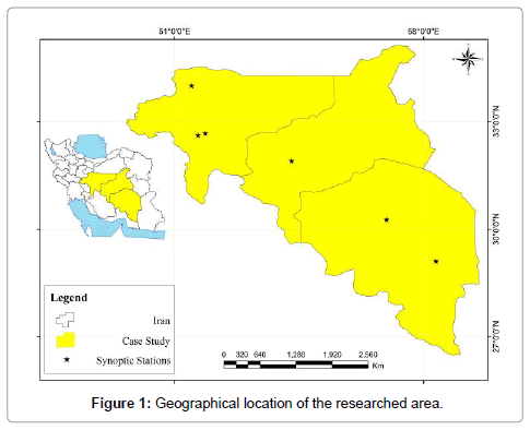
Figure 1: Geographical location of the researched area.

Where, Pi is precipitation in year i, is the average precipitation during statistical period, SD is the set standard deviation of precipitation. Positive amounts of index show precipitation more than median and negative amounts show different intensities of drought (Table 1). After identifying the wet years by using SPI index, 38 wet months were identified with the spatial occurrence condition more that 50 percent, then by peripheral circulation approach for identifying the circulation patterns of wet periods, daily data of 500 HPa geo-potential height level in the given months were exploited. Data of 500 HPa geo-potential height level in array 609*306 (306 showed the day and 609 showed the points arrangement) was selected which was extracted from the website of the national center of environmental prediction/national center of atmospheric researches by special separation of 2/5*2/5 degree, in the domain of 10 to 80 degree west longitude, and 20 to 70 degree north latitude. Then by conducting the principle component analysis by correlation method and components rotation by Varimax, effective components were identified. Then by cluster analysis and calculating Euclidean distance and Ward method on component amounts, the circulation pattern of wet period was identified, and in each cluster or category one day was chosen and investigated as the key or pattern day. Principle component analysis has three output: spatial patterns (component load array), temporal pattern (component amount array), and component explaining diffraction array. For selecting the most important components, the explaining principle of more that 1 percent was considered. So we used only those components for the next analysis that explained more than 1 percent of variations in 500 HPa geo-potential height level. Spatial patterns map for identifying the most effective components at the time of frozen phenomenon at the abovementioned levels were drawn, and in the next step, a cluster analysis by ward integration method on component amounts was conducted for identifying the map patterns of wet periods, so in each cluster, one day was introduced on the basis of most intra-group correlation as the representative day or circular pattern. The map of representative days or circular patterns were exploited in the introduced coordinate framework, and processed. For calculating the distance, the following Euclidean distance relation was used:
| Standard precipitation index | Index value |
|---|---|
| 2 and more | Very severe wet years |
| 1.5 to 1.99 | Severe wet years |
| 1 to 1.49 | Middle wet years |
| -0.99 to 0.99 | Normal |
| -1 to -1.49 | Middle drought |
| -1.5 to -1.99 | Severe drought |
| -2 and less | Very strong drought |
Table 1: Different intensities of drought based on Standard Precipitation Index.
Where: n is the people number, Xi, p the amount of p variable in day i, X j, p is the amount of variable p in day j. And for calculating the integration or data binding the ward relation was used:

Where d is cluster Euclidean distance, I, j, k (C= Cluster) - Ci, Cj, CK each one is considered as a separate cluster.
Results And Discussion
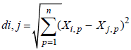
On the basis of diffraction array of principle component exploring, the explained percentage by each of the components of 500 HPa geopotential height level data were calculated for wet years patterns (Figures 2-9). So by 8 components, 94 percent variation in geo-potential height data was explained (Table 2). The first component explained 62.3 percentage of data diffraction of 500 HPa geo-potential height level in wet periods. Spatial patterns of this component showed that there were negative and positive steps in the researched area. The positive step dominant in central Iran showed a low height that provide the occurrence condition of atmosphere instability, and the negative step showed polar high pressure and Siberia high pressure which had two separate cow-eye patterns. Therefore, this component had the highest percentage of variation diffraction of geo-potential elevation data, and was the most effective pattern in wet period events in the research area (Figure 2). The probability of precipitation event in this component in wet years could be the lowest amount according to the available components, and this component showed the peak instabilities. The second component with 11.1 percent explained the diffraction of 500 HPa geo-potential height level data in wet periods. Spatial patterns of this component showed that the positive step located on Red sea and in the east of Mediterranean sea had affected the researched area, and provided the instability condition and humidity ascend on both seas, Therefore, in wet periods, the important component was the entrance of humidity of Red sea from the southwest towards Iran and the researched area (Figure 3). The third component explained 8.1 percent of diffraction of 500 HPa geo-potential height level data in wet periods. Spatial pattern of this component showed that there are several cow-eye patterns in the researched area, therefore two adjacent step one on the Mediterranean sea with positive step could be regarded as high elevation, and the other one with negative step which was located on Iran was considered as low elevation that caused the atmosphere instability in the researched region (Figure 4). The fourth component explained 3.9 percentage of diffraction in data of 500 HPa geo-potential height level in wet periods. Spatial pattern of this component showed that there were two important centers with different steps in the given region, negative step which was expanded from Red sea to Caspian sea and had affected the researched area, and the positive step which was located in the north of Black sea and Mediterranean sea, so according to the location of both steps, negative step could be considered as high elevation which had anticyclone and clockwise movements and made proper conditions for penetration of sea humidity towards the region, and the positive step was regarded as sub-polar low elevation which was extended to lower latitudes (Figure 5). The fifth component explained 3.2 percentage of diffraction in 500 HPa geo-potential height level data in wet period. Spatial pattern of this component showed that a center with negative step is dominant in west of Iran, a low elevation which showed the penetration of Red sea and Mediterranean sea moisture, and the positive step showed the high pressure of the North-west of Europe (Figure 6). The sixth component showed 2.6 percentage of diffraction of 500 HPa geo-potential height level data in wet periods. Spatial pattern of this component showed that there is a center with negative step in the north of Caspian Sea and Aral Lake, and was under the domination of Siberia high elevation, and the researched area was under the domination of low elevation (Figure 7). The seventh component showed 1.3 percentage diffraction of 500 HPa geo-potential height level data in wet periods. Spatial pattern of this component showed that a center with negative step was dominant on the region which showed low elevation and caused a very sever unstable condition, and provided the probability of heavy precipitation (Figure 8). The eighth component showed 1.2 percent diffraction of 500 HPa geo-potential height level data in wet periods. The spatial pattern of this component showed that a center with negative step was dominant in the region which showed a low elevation and caused a very sever unstable condition, and provided the probability of a heavy precipitation occurrence (Figure 9). The seventh and eighth components could show very heavy precipitations in the researched area, and was effective in causing wet years, and showed the first component of dominant weather during the year.
| Components | First | Second | Third | Fourth | Fifth | Sixth | Seventh | Eighth |
|---|---|---|---|---|---|---|---|---|
| Expression percentage | 62.3 | 11.1 | 8.1 | 3.9 | 3.2 | 2.6 | 1.3 | 1.2 |
Table 2: Component percentages estimated from principle component analysis.
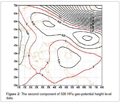
Figure 2: The second component of 500 HPa geo-potential height level data.
Figure 3: The first component of 500 HPa geo-potential height level data.
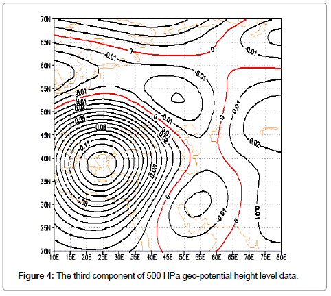
Figure 4: The third component of 500 HPa geo-potential height level data.
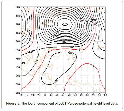
Figure 5: The fourth component of 500 HPa geo-potential height level data.
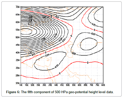
Figure 6: The fifth component of 500 HPa geo-potential height level data.
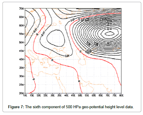
Figure 7: The sixth component of 500 HPa geo-potential height level data.
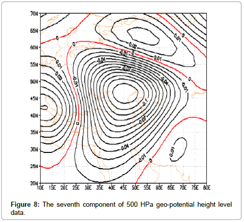
Figure 8: The seventh component of 500 HPa geo-potential height level data
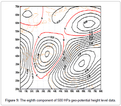
Figure 9: The eighth component of 500 HPa geo-potential height level data.
Circular pattern of cluster analysis of wet periods
Cluster exploration on agent amounts of analyzing the main component shows that 4 map patterns in occurrence of wet periods can be identified (Table 3).
| patterns | Correlation of representative day | Intre-group correlation | Frequency | year | month | day | Year | month | day |
|---|---|---|---|---|---|---|---|---|---|
| A | 0.85 | 0.78 | 28 | 1378 | 1 | 7 | 1993 | 3 | 27 |
| B | 0.89 | 0.84 | 22 | 1388 | 3 | 13 | 2009 | 6 | 3 |
| C | 0,84 | 0.75 | 35 | 1377 | 5 | 28 | 1998 | 8 | 19 |
| D | 0.91 | 0.88 | 15 | 1390 | 9 | 2 | 2011 | 11 | 23 |
Table 3: Representative days obtained from cluster analysis.
Pattern A (wet years): This pattern has the frequency of 28 percent in wet periods which is in the second order among map patterns. 27 March 1999 was chosen as the representative or pattern day based on correlation analysis. Map pattern of 500 HPa geo-potential height level shows that a deep trough in the east of Mediterranean Sea and Red sea is formed and leads to trough east lying on the researched area. The presence of this cold hole in western part of Caspian Sea with closed contour 555 geo-potential meters can be observed (Figure 10). Moreover, high elevation system (anticyclone) with closed contour 590 geo-potential meters was formed on Arab sea, and by clockwise circulation led to humidity transport above Arab and Oman Sea toward central part of Iran. Map pattern of sea level pressure shows that Siberia high pressure center is dominant in north and east of Iran, and above Iran there is a low pressure center with closed contour 1010 HPa that cause instability (Figure 11). High pressure center on mountain region of Anatoly was formed on closed contour 1010 HPa. In this pattern, according to sea level pressure and level 500 HPa, it can be concluded that accompaniment of atmosphere levels in making instability in the region is effective, and if humidity is provided, precipitation can occur, and this pattern is so effective in occurrence of wet periods.
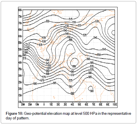
Figure 10: Geo-potential elevation map at level 500 HPa in the representative day of pattern.
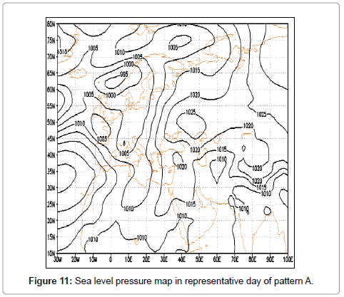
Figure 11: Sea level pressure map in representative day of pattern A.
Pattern B (wet years): This pattern has the frequency of 28 percent in wet periods, and 3 June 2009 was chosen as the representative or pattern day based on correlation analysis. Map pattern of 500 HPa geo-potential height level shows that a trough is formed on the Mediterranean sea, and also a ridge with focus on north of Caspian sea is formed and in this situation by making an atmosphere barrier lead to laying of ridge east on the region, and lead to falling of cold currents into Iran (Figure 12). Map pattern of sea level pressure shows that sub-polar low pressure is extended towards low latitudes and leads to extension of Siberia high pressure tongue and combined high pressures (Siberia-Europe) into Iran, and the researched area is under the domination of high pressure tongues (Figure 13). Investigating the tow-mentioned levels shows that in the middle level of atmosphere there is cold air falling of high latitudes, and at the sea level there are high pressure centers. Conformation of atmosphere levels in this situation leads to coldness and reduction of temperature in the region, there is no condition of precipitation, so in wet years in this region such situation is not far from expectations.
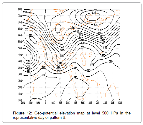
Figure 12: Geo-potential elevation map at level 500 HPa in the representative day of pattern B.
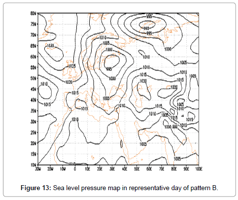
Figure 13: Sea level pressure map in representative day of pattern B.
Pattern C (wet years): This pattern has the frequency of 35 percent in wet periods, which has the first rating among map patterns. 19 May 1998 was chosen as the representative or pattern day based on the correlation analysis. Map pattern of geo-potential elevation height at level 500 HPa shows that High pressure (Azor) penetrates into Iran from north of Africa, and this current leads to air falling to lower levels, and provides stable condition for the atmosphere, and sub-tropical high pressure with contour 590 geo-potential meter covers (embrace) Iran (Figure 14). Two central core of this high pressure with closed contour of 595 geo-potential meter in south west of Iran and Algeria are formed. Map pattern of sea level pressure shows that low pressure centers are formed which are extended toward Persian Gulf and the researched area (Figure 15). The central core of this low pressure with closed contour 1000 HPa is located in the southern coast of Persian Gulf. This pattern shows the hot period of the year (The first 6 month) which is appearing with 35 percent frequency. Therefore, in this pattern there is no condition of precipitation and this is one of the properties of the weather in this region.
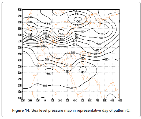
Figure 14: Sea level pressure map in representative day of pattern C.
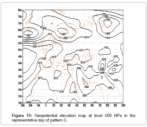
Figure 15: Representative photomicrograph of histopathological features in pulmonary necropsies.
Pattern D: This pattern has the frequency of 15 percent in wet periods, which has the 4th rating among map patterns. 23 October 2011 was chosen as the representative or pattern day based on the correlation analysis. Map pattern of 500 HPa geo-potential height level shows that a trough with focus on Caspian sea to the center of Persian Gulf is formed, and there is a ridge with focus on Mediterranean sea which leads to falling of cold air on Iran, and in western regions which are located under the upper divergence of trough, there is the probability of atmosphere downpour (Figure 16). Map pattern of sea level pressure shows that a high pressure center in west Europe with closed contour of 1035 HPa is formed, and its tongue penetrates into Iran, and the researched area is under the domination of high pressure, and two high pressure systems are seen in the north of Baikal lake and Tibet plateau (Figure 17). Therefore, agreement of these two levels in this pattern shows the condition of cold air falling, if low pressure center is formed in the region, and based on the east of the present trough, instability is established, and is effective in occurrence of precipitation in the eastern part of the researched area. Disagreement of atmosphere levels in the absence of humidity provides the condition of dust. Iran, and specially the researched area, is under the domination of dust condition. In general, according to the results, this investigation is in agreement with the investigation conducted by Khoshakhlagh which was conducted in the West south of Iran about the spatial position of Mediterranean Sea trough axis. Moreover, in the research done by Atayi et al. [7] the circulation patterns of pluvious period show a deep descent on Iraq and the establishment of the researched region at the eastern part of the descend which is in a good agreement with the results of the present study.
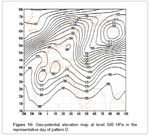
Figure 16: Geo-potential elevation map at level 500 HPa in the representative day of pattern D.
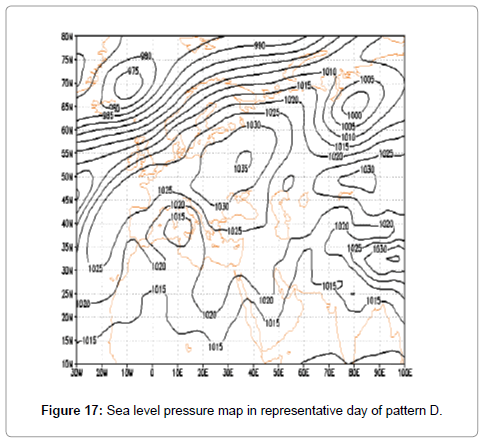
Figure 17: Sea level pressure map in representative day of pattern D.
Conclusion
According to the close relationship between atmosphere circulation patterns and climatic elements, weather extreme phenomena like flood and drought, and dry and wet periods can be related to variations of atmosphere circulation patterns [26]. Therefore, in the present study by using principle component analysis and clustering, eight components were identified on the researched area in wet periods which can explain 94 percent of data variations in level height of 500 HPa. The results of the main component analysis in wet periods show that the first component with the highest percentage of appearance has the main role among circulation patterns and determines the dominant pattern in cold periods of the year, and its negative step shows polar and Siberia high pressure which have two separate cow-eye patterns. Therefore, this component has the highest percent of diffraction in data variation of geo-potential elevation, and is the most effective pattern in wet periods of the region, and by 62.3 percent explains the variation diffraction, which does not have the condition of precipitation with penetration of high pressure or high elevation tongue, and the remaining components based on the negative and positive steps of centers show atmosphere instability which penetrate the region from Mediterranean sea, Black sea and Red sea and lead to exit from drought and experience wet period in the region. Investigating the circular patterns of sea level pressure and geo-potential elevation of middle level of atmosphere in wet period shows that the arrangement of circulation patterns with 28 percent frequency provides the condition of precipitation, and in other patterns 15 percent probability of precipitation is provided, and the absence of humidity may lead to dust occurrence [27,28]. Therefore, map pattern of 500 HPa geo-potential height level at the time of precipitation shows that a deep trough in east of Mediterranean sea and Red sea is produced which lead to establishment of east through on the region, and map pattern of sea level pressure shows that there is a low pressure center on Iran, and also covers the researched area. The situation of the middle level of atmosphere and sea level pressure provide the conditions of instability and ascend and leads to precipitation in this region, or if there is no humidity, dust may occur. Therefore, 43 percent of times, there is the probability of precipitation. The arrangement of circulation patterns in the remaining times in wet periods shows that in the middle level of atmosphere by formation of trough, the researched region would be at the west part of the axis which is the place of cool air falling of upper latitudes, and in the sea level, center or tongues of high pressure of north, west and north east of Iran would extended on the region which because of stability, prevent the ascend of humidity if present, and prevent precipitation in this region. In general, identifying the atmosphere circulation patterns can be effective in weather forecast, regional planning and climatic models [29,30]. Therefore, according to the lack of related studies in the researched area, conducting more researches help us to understand and recognize the region`s weather better.
References
- Behzadi J (2011) Monitoring drought and analyzing its properties in Gilan province, Iran. Geography and land use planning. 1st year 1: 21-36.
- Alijani B, Jafarpour Z, Ali Akbar Bidockti A, Mofidi A(2007) Synoptic Analysis of monsoon precipitation circulation patterns in July 1994 in Iran. Geography sci J 7th year, 10: 7-38.
- Alijani B, Khosravi M, Smaeilnejad M(2010) Synoptic analysis of heavy precipitation of 6 January 2008 in southeast of Iran, Climatology researches, 1th year 3: 1-12.
- BaratiGh, Badaghjamali J, Maleki N (2012) The role of anticyclones in occurrence of heavy precipitations in recent years in West of Iran. Natural Geography Researches, Year 44, 80:Â 85-98.
- Halabian A, Hossein Ali Pourhazi F (2012) Identifying synoptic condition of partly and pervasive precipitation in western part of Caspian sea with emphasis on atmosphere thickness patterns, Geography and environmental stability, 2nd year, 3: 101-122.
- Fatahi E, Behyar M (2011) Investigation of synoptic patterns of pervasive drought in Chahar-mahal and Bakhtiyari Province, Iran. Geography researches, 26th year, 101: 79-100.
- Atayi H (2008) Identify and analysis of patterns of atmosphere middle level in high rainfall years in Iran. Geography researches 90: 19-38.
- Mohammadi B, Masoudian A (2007)Â The relationship between synoptic type of Sanandaj Station air with circulation patterns at level 500 HPa, Geography and development, Term 5, 9: 39-56.
- Raziei T, Saghafian B, Paulo AA, Pereira LS, Bordi I (2009) Spatial patterns and temporal variability of drought in western Iran. Water Resources Manage23: 439-455.
- KhoshAkhlagh F, Azizi GH, Rahimi M (2012) Synoptic patterns of winter drought and wet years in southwest of Iran. Applied researches in geography sci 12th year, 25: 57-77.
- AziziGh, Alizadeh T (2014) The relationship between sea level circulation patterns type, with pervasive precipitations in Iran. Natural geography researches, Term 46: 297-310.
- Galambosi A, Duckstein L, Bogardi I (1996) Evaluation and analysis of daily atmospheric circulation patterns of the 500 hPa pressure field over the southwestern USA. Atmospheric research40: 49-76.
- Svensson C (1999) Empirical orthogonal function analysis of daily rainfall in the upper reaches of the Huai river basin, China. Theoretical and applied climatol62: 147-161.
- Kassomenos PA (2003) Anatomy of the synoptic conditions occurring over southern Greece during the second half of the 20th century. Part I. Winter and summer. Theoretical applied climatol75: Â 65-77.
- Duckstein L, Bárdossy A, Bogárdi I (1993) Linkage between the occurrence of daily atmospheric circulation patterns and floods: an Arizona case study. J Hydrol143: 413-428.
- Corte-Real J, Qian B, Xu H (1998) Regional climate change in Portugal: precipitation variability associated with large-scale atmospheric circulation. Int J Climatol18: 619-635.
- Buntgen U, Trouet V, Frank D, Leuschnr HH, Friedrichs D et al. (2010) Tree-ring indicators of German summer drought over the last millennium. Quaternary Sci Rev29: 1005-1016.
- Shahabfar A, Ghulam A, Eitzinger J (2012) Drought monitoring in Iran using the perpendicular drought indices. Int J Applied Earth Observation Geoinformation 18: 119-127.
- Keshavarz M, Karami E (2014) Farmers' decision-making process under drought. J Arid Environ 108: 43-56.
- Golian S, Mazdiyasni O, AghaKouchak A (2014) Trend s in meteorological and agricultural droughts in Iran. Theoretical and Applied Climatol 119: 679-688.
- Farhangfar S, Bannayan M, Khazaei HR, Baygi MM (2015) Vulnerability assessment of wheat and maize production affected by drought and climate change. Int J Disaster Risk Reduction 13: 37-51.
- Rahmani A, Golian S, Brocca L (2015) Multiyear monitoring of soil moisture over Iran through satellite and reanalysis soil moisture products. Int J Applied Earth Observation and Geoinformation.
- Hayes MJ, Svoboda MD, Wilhite DA, Vanyarkho OV (1999) Monitoring the 1996 drought using the standardized precipitation index. Bulletin Am Meteorol Soc80: 429-438.
- Ibrahim K, Zin WZW, Jemain AA (2010) Evaluating the dry conditions in Peninsular Malaysia using bivariate copula. ANZIAM J51: 555-569.
- Mckee TB, Doesken NJ, Kleist J (1993) The relationship of drought frequency and duration to time scales. In: Proc. 8th conference on applied climatol January 179- 184.
- BabayiFini O, Fatahi E (2014) Classification of synoptic patterns of causing precipitation in the coast of Caspian sea. Natural Geography Researches Year 46: 19-42.
- Jahanbakhsh S, Jafari SF, Hossein Ali Pourgazi F (2012) Investigating the relation of upper atmosphere circulation patterns with heavy cloud precipitation (Case study of eastern Azarbayjan Province, Iran), Geography and Planning, Term 17, 42: 113-138.
- RezayiBanafshe M, Balyani Y, Zinali B(2011) Estimation of drought and wet years (1982-2006) on the basis of indexes based on precipitation for stations of Parishan lake watershed, Talab Magazine, 7th 19-29.
- Trigo RM, Dacamara CC(2000) Circulation weather types and their influence on the precipitation regime in Portugal. Int J Climatol20: 1559-1581.
Citation: Fatemi M, Omidvar K, Beiglou KHB, Narangifard M (2015) Using Principle Component Analysis in Identifying Synoptic Patterns of Wet Periods in Central Iran. J Earth Sci Clim Change 6(9): 309. DOI: 10.4172/2157-7617.1000309
Copyright: © 2015 Fatemi M, et al. This is an open-access article distributed under the terms of the Creative Commons Attribution License, which permits unrestricted use, distribution, and reproduction in any medium, provided the original author and source are credited.
Select your language of interest to view the total content in your interested language
Share This Article
Recommended Journals
Open Access Journals
Article Tools
Article Usage
- Total views: 11763
- [From(publication date): 11-2015 - Aug 16, 2025]
- Breakdown by view type
- HTML page views: 10844
- PDF downloads: 919