Waha Reservoir Characterization and Distribution in the Ralah Field, Concession 6, Sirte Basin, Libya
Received: 19-Feb-2019 / Accepted Date: 22-Mar-2019 / Published Date: 03-Apr-2019 DOI: 10.4172/2573-458X.1000171
Abstract
The Ralah field is one of the concession 6 fields operated by sirte oil company. It is located in the southern part of the Sirte Basin (Libya), approximately 200 km south of the Mediterranean Sea. The upper cretaceous waha formation is the main producer in the Ralah Field. This reservoir is very complex and more heterogeneous. The Ralah Field was discovered in June 1964 with the drilling of DD1-6 well through the Waha formation and proved to be the most prolific reservoir in the area. The 2D seismic surveys were performed. In 2004 a 3D seismic survey of 340 km² was completed to evaluate remaining potential. The seismic interpretation has acquired new drillable well locations. From the history of the field, it is obvious that there have been successes and failures in the Waha reservoir in the Ralah Field. This can be attributed to facies variation, thickness and reservoir properties. Seismic and well data of nineteen wells have been used in this project. Waha reservoir was evaluated, analyzed and interpreted in order to gain a better understanding of the reservoir distribution over the study area. Seismic interpretation and coherence attribute analysis were performed for the fault trend identification; and using petrel software, Property models were constructed in terms of clay volume, porosity, permeability and hydrocarbon saturation. The aim of studying these properties is to decrease the risk and uncertainty of drilling infill wells in the field.
Keywords: Ralah field; Waha formation; Coherence attribute; Property models
Introduction
The Ralah field is one of the concession 6 fields operated by Sirte oil company. It is located in the southern part of the Sirte Basin (Libya), approximately 200 km south of the Mediterranean Sea. Geographically it is located between latitude 28°42′12″ and 28°51′40″ North and longitude 19°51′ 58″ and 19°59′57″ East (Figure 1). The Ralah field area is separated from the Nasser field by an apparent undrilled and hitherto hydrocarbon-barren region, which is at intermediate structural levels between the Nasser and Ralah accumulations. The upper cretaceous Waha formation in the Ralah field is the main producing interval for cretaceous sediment units and has a complex facies stacking of mixed carbonate-clastic, siliciclastic and limestone facies. It overlies the pure sandstone of the Bahi formation, separated by an unconformity; the Waha formation is capped by the tight, argillaceous limestone of the Kalash formation. Reservoir distribution over the Ralah field which has structural and stratigraphic complexity.

Figure 1: Location map of the study area.
Field exploration history
The Ralah field was discovered in June 1964 with the drilling of DD1-6 well through the Waha formation and proved to be the most prolific reservoir in the area. Since then nineteen wells have been drilled. The Ralah wells are distributed over four accumulations (pools) (Figure 2). Development drilling of the Ralah field was sporadic. Three wells, DD2-6, DD3-6 and DD4-6 were drilled in 1965. DD2-6 was completed as a Waha oil producer. DD3-6 and DD4-6 found the Waha wet. DD5-6 and DD6-6, drilled in 1967, were completed as oil wells. DD7-6 and DD9-6, drilled in 1970, found the Waha wet. DD8-6 as a replacement well for DD1-6 was considered but never drilled. DD10-6 was drilled and completed successfully in 1984 as a Waha oil producer. DD11-6 was drilled in 1987 as a replacement well for DD1-6. DD12-6 was drilled and completed as a Waha oil producer in June 1992. DD13-6 found the Waha tight and did not flow. DD14-6 was drilled in late 2002 is awaiting gas lift so it can be evaluated. DD15-6 was drilled and completed in 2003 as a Waha oil producer. DD16-6 and DD17-6 were drilled in 2006, completed as oil wells. DD18-6 was drilled and completed as a Waha oil producer in 2010. DD19-6 was drilled in 2012 and completed as a Harash oil producer, a higher reservoir. DD20-6 was drilled and completed as a Waha oil producer in 2013. Finally, DD21-6, the Waha reservoir was missing and so it was plugged and abandoned. (Source: Sirte Oil Company, data base).

Figure 2: 3D Seismic base map shows the well locations and four pools in the study area.
Seismic activities on this field: Several 2D seismic surveys were done in the Ralah field. In 2004 a 3D seismic survey was completed to evaluate remaining and upside potential. The seismic data which have been used in this study is a part of the South East Nasser 3D survey, this part of the 3D cube covers all the area of study approximately 340 km².
Regional tectonic setting of sirte basin
Orogenic movement affects most of North Africa Plate during the Early Cretaceous (Aptian). Due to this movement, the Sirte Basin was rifted (Figure 3) [1,2]. The formation of NW-SE faulting system of horst and graben patterns started in the early cretaceous and reached a peak during the paleogene. A cenomanian marine transgression flooded and drowned all but major horst block highs in the basin. The sea continued to advance south wards, and by the end of maastrichtian only few scattered crests remained above the sea level as isolated islands [3]. From the maastrichtian to upper eocene, the basin was characterized by significant basin subsidence and continued transgression with minor regression. Throughout this time period, all the source rocks, reservoirs and seals were formed. Traps and migration of hydrocarbon from source rocks were developed in the final structure stage to be accumulated in the different reservoirs during the early oligocene to the pleistocene epoch [4].

Figure 3: The structural elements (Horst-Graben Patterns) of the Sirte Basin and the location of the study area (Sirte Oil Com, data base).
Stratigraphic setting of sirte basin
The sirte basin accumulation history can be related to three successive rifting events that have been classified into Pre-rift, Syn-rift and Post-rift successions [5]. The Pre-rift and Post-rift sediments are dominated by clastic, whereas the Syn-rift (Late Cretaceous to Late Eocene) sediments are represented by mainly marine deposits. These sediments were deposited in different depositional environments due to the change of sea level fluctuation (transgression or regression) and controlled by NW-SE oriented horst and graben structures. The cretaceous sediments overlay the gargaf formation. These sediments are represented by multi age lithology, the Bahi, Waha, Sirte Shale, Arshad and Kalash formations. The Bahi, Waha and Arshad formations are considered as principal reservoirs whereas the sirte shale formation is the source rock. The kalash formation is widespread in some places of central sirte basin and acts as a cap rock in the area of study [6]. All the events, formations and ages are summarized in Figure 4.

Figure 4: Generalized columnar stratigraphic section of concession 6, Zelten platform Central Sirte Basin showing Pre, Syn and Post-rift sediments. (Modified after Barr and Weegar, 1972).
Petroleum system
In Libya, more than 80% of the hydrocarbon has been found in structure traps. Four petroleum elements, reservoir source rock, timing, migration mechanisms, reservoir rocks and seal rocks were studied in detail in this project.
Source rocks: The main source rocks for the Sirte Petroleum System are represented by the Upper Cretaceous (Campanian) Sirte Shale and Rachmat.
Timing and hydrocarbon migration: Many source rock studies summarized that, Sirte shale and Rachment sources achieved mid-late maturity but Rachment from late Paleocene to late Eocence, whereas Sirte shale from early Eocene to middle Miocene and likely to have continued to the recent. The Sirte Basin is considered to be an example of a complex petroleum system in which petroleum sourced from Upper Cretaceous shales has migrated into multiple age reservoirs, mainly vertically into carbonate build-ups along the various horsts and along the raised carbonate platforms. The drainage timing was good because of the structural and stratigraphic traps developed in the Late Paleocene time.
Reservoir rocks: Multiple age reservoirs have been recognized in sirte basin, the main upper cretaceous reservoirs on zelten platform is Waha formation (sandstone and sandy limestone of shallow marine environment). The Waha formation is the main reservoir in the Ralah field varies in lithological composition from sandy limestone to calcareous sandstone, with a porosity of 13% to 18% and good permeability, ranging in thickness from few feet to a hundred feet.
Seal rocks: The upper cretaceous Waha/Bahi reservoirs are sealed by the Kalash formation (tight micritic limestone) and the shale of Hagfa formation. These two formations overlay each other and provide a thick regional seal and extend over most of the Zelten platform.
Methodology
The 3D seismic data of 340 km², which covered all the Ralah field area, have been used in this study. Core and log data of nineteen wells have been provided by the Sirte oil company in order to achieve the objective of this project. Data evaluation, analysis and interpretation were done for the whole reservoir interval. Petrel™ software has been used to interpret seismic lines and faults. Interactive petrophysics software™ (IP) was selected to do the petrophysical analysis for the wire line logging data to determine the reservoir properties in terms of clay volume, porosity, permeability and hydrocarbon saturation. These analysis were loaded to the Petrel™ software in order to build a static model of the Waha formation in the Ralah Field.
Petrophysical analysis of Ralah field
The determination of the Waha reservoir properties and its fluid contents (porosity, permeability, water saturation and percentage of shale volume) are achieved by using a suite of wire line geophysical logs (Gamma ray, Porosity and Resistivity logs…etc.). Logs were loaded into Interactive Petrophysics and full petrophysical analysis was performed for the all wells in order to provide a consistent approach to the interpretation (Figure 5).

Figure 5: Composite log shows the petrophysical analysis of well DD10-6 in the Ralah field.
Shale volume calculation: Waha reservoir in Ralah Field does not contain high uranium concentration. Therefore, shale volume was calculated for most of the wells mainly from GR (linear equation); neutron-density was used in few wells.
Porosity estimation: Porosity was determined from the major indicators of density-neutron cross plot (Figure 6), single density and sonic logs. Density log was used to calculate the porosity in most of the wells except in wells where density logs were not available (DD1-6 to DD9-6); sonic logs were used to calculate the porosity in those wells.

Figure 6: The neutron-density cross-plot of the Waha formation in well DD10, show porosity and lithology variations.
Water saturation estimation: Water Saturation was calculated using the Archie equation method; which depends on the resistivity log measurements in clean formation.
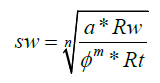
Where: Sw=water saturation. Rw=0.035 ohmm @ 210 degF (well test measurement). Ø=Effective porosity (N-D cross-plot method). Rt=Deep resistivity readings. n=Saturation exponent=2. a=formation factor = 1. m = cementation exponent= 2.

Figure 7: Core porosity vs core permeability cross-plot of DD10-6 well.
Seismic interpretation of the Ralah field
A 3D seismic survey of 340 km² was completed to evaluate remaining potential in 2004 and 2D before it. Due to the thinning of the Waha formation, which is under the seismic resolution, it is difficult to pick the top horizon of the Waha reservoir. The target of this part of study is to identify the Kalash limestone and Bahi/Gargaf reflectors. The overlying horizon (Kalash Formation) is a widespread and strong enough to be mapped, indicating the top of Reservoir window; the top of Bahi/Gargaf lies one cycle below the top Kalash indicating for the bottom of the reservoir window. Generally this pick relates to the top of lower cretaceous sand of the bahi formation, but in certain high regions this is absent and the pick reverts to the underlying paleozoic cambro-ordovician gargaf quartzite, this horizon is depicted as the top of the bahi sandstone formation. All of the major and minor faults were recognized; the coherence of seismic attribute was also applied on the seismic data. Both show that most of the faults in the Ralah Field are normal and trend in NW-SE direction (Figures 8 and 9).

Figure 8: X-line 468 illustrates normal faults in the Ralah Field.

Figure 9: Coherence seismic attributes show the dominant NW-SE trend of faults and fractures in the Ralah field.
Facies Discrimination
Complex facies stacking of mixed carbonate-clastic, siliciclastic and limestone with an overall deepening up were identified from core and thin section descriptions for all Waha reservoir in the key well DD10-6. There was a good correlation between core and log data (porosity and permeability) (Figure 10). However, based on the log motifs to the distinguished facies, detailed facies zones were correlated to the all of Ralah Field and well correlation panel was created. Figure 11 showed thickening of the Waha reservoir toward south e.g. DD3- 6, whereas in paleohigh on Bahi/Gargaf, the Waha reservoir is either absent or very thin e.g. DD21-6. Seismic mapping of the Bahi-Gargaf also corroborates this observation.

Figure 10: Well DD-10 with porosity & permeability values and clay volume logs against stratigraphic succession.

Figure 11: General geological structural correlation of the Ralah wells shows that on the paleohigh of Bahi-Gargaf, Waha reservoir is missing, e.g DD21-6. An overall thickening towards south is also noted.
Rerservoir static models
The aim of a geological reservoir model is to provide a complete set of continuous reservoir parameters (porosity, permeability, clay volume and water saturation) for each cell of the 3D grid. The reservoir proprties were subsequently upscaled to the reservoir grid ang distributed in the model by stochastically method using Sequential Gaussian Simulation algorthim. The figures below Figures 12-14 explain the distribution of Shale volume, effective porosity and water saturation respectively, around the Ralah wells. The water saturation distribution showed a good correlation with well performance, e.g. DD3-6 well falls in high water saturation zone, whereas DD10-6 well falls in low water saturation zone. Shale volume and effective porosity models show the reservoir heterogenity in all the studyed wells. Few areas of good reservoir quality clusters are observed although no trend can be inferred. Most of the water saturation Vs shale volume cross plots which were generated in this study indicated that, increasing the water saturation with increasing shale quntity the in the reservoir. Comparing this distribution with shale that estimated from logs, only a small differents were found.

Figure 12: Clay volume model of the Waha reservoir.

Figure 13: Effective porosity model of the Waha reservoir.

Figure 14: Water Saturation model of the Waha reservoir.
Conclusions
This study was an integrated approach using petrophyscial anaysis, seismic interpretation, core analysis and reservoir modeling to better understand the reservoir property distribution in the Ralah Field. This integration inferred that the best reservoir is deposited in the flank with mixed reworked sandstone and limestone e.g. DD10-6. In the outer flank, although thicker reservoir sections are present, it is structurally lower and in water zone e.g. the dry well DD3-6. At the crest, the Waha Reservoir was not deposited e.g. DD21-6. Seismic interpretation and coherence attribute analysis showed the fault trends. All the major and minor faults were recognized in the Ralah Field are normal and trend in NW-SE direction. Complex facies stacking of mixed carbonate-clastic, siliciclastic and limestone with an overall deepening up were identified from core analysis for all Waha reservoir in the key well DD10-6. The most producible facies are Rudstone, and Bioclastic Sandstone because they have good reservoir properties (PHIE=13-25% & K=1-30mD) and less amount of clay volume. Uncertainties involved in this study arises from a) out of nineteen wells, only one well had cores for the entire reservoir, moreover in many wells some of the logs were not present (e.g. PEF, NPHI and RHOB); b) the reservoir is heterogeneous due to complex lithology and facies variation, which affected the property model and a distinct trend in property distribution was not observed and c) the analysis was mainly based on conditioning to the wells as no suitable seismic attribute was found. This resulted in uncertainties away from the wells.
Acknowledgement
I would like to thank the authority of Sirte Oil Company in Libya for providing the required data upon which this work is based.
References
- Anketell JM (1996) Structural history of the sirte basin and its relationship to the sebratah basin and cyrenaica platform, North Libya. The Geology of Sirte Basin 3: 57-87.
- Duronio P, Colombi L (1983) Mesozoic rocks of Libya, Spec. Pap, Petroleum Exploration Society Libya Pp: 1-12.
- Baird DW, Aburawi RM, Bailey NJL (1996) Geohistory and petroleum in the central Sirte basin. First symposium on the sedimentary basins of Libya, geology of the Sirte basin 3: 3-56.
- https://www.academia.edu/34878968/STRATIGRAPHIC_NOMENCLATURE_OF_THE_SIRTE_BASIN_LIBYA_THE_PETROLEUM_EXPLORATION_SOCIETY_OF_LIBYA_TRIPOLI_LIBYA
- Thomas D (1995) Exploration limited since 70s in Libya’s Sirte basin. Oil & Gas J 93: 99-104.
Citation: Fawzi SFH (2019) Waha Reservoir Characterization and Distribution in the Ralah Field, Concession 6, Sirte Basin, Libya. Environ Pollut Climate Change 3: 171. DOI: 10.4172/2573-458X.1000171
Copyright: © 2019 Fawzi SFH. This is an open-access article distributed under the terms of the Creative Commons Attribution License, which permits unrestricted use, distribution, and reproduction in any medium, provided the original author and source are credited.
Select your language of interest to view the total content in your interested language
Share This Article
Recommended Journals
Open Access Journals
Article Tools
Article Usage
- Total views: 5796
- [From(publication date): 0-2019 - Dec 17, 2025]
- Breakdown by view type
- HTML page views: 4681
- PDF downloads: 1115