Depositional Environment of Siliciclastic Deposits on the Western Flank of the Anambra Basin, South West Nigeria: Insights from Sedimentary Facies Analysis
Received: 26-Apr-2018 / Accepted Date: 14-May-2018 / Published Date: 18-May-2018 DOI: 10.4172/2157-7617.1000471
Abstract
This paper presents one of the most detailed facies analysis of the siliciclastic rocks on the western flank of Anambra basin, Southwestern Nigeria. The study is based on four stratigraphic outcrop sections exposed as road cuts and cliff surface of river channel in Auchi and Fugar environs. The stratigraphic sections were studied in terms of lithology, textural characteristics, sedimentary structures, geobody geometry, paleocurrent signatures and bed forms, allowing the recognition and organization of facies into facies associations in order to interpret the depositional environments. Nine lithofacies were recognized namely, structured to massive conglomerate facies (Gmm), fine- to medium-grained, planar cross bedded, sandstone facies (Sx), thick-bedded, medium-grained, moderately-sorted, sandstone facies with rashes of sub vertical Ophiomorpha burrows (Sxb), medium-grained, moderately-sorted, planar cross laminated, quartzose sandstone facies (Sxl), coarse to medium-grained, massive, sandstone facies (Sm), fine- to coarse-grained, trough cross bedded, quartzose, sandstone facies (St), medium-grained, moderately sorted, herringbone cross stratified, reddish brown sandstone facies (Sxh), fine-grained, moderately sorted, fine-grained, white, hummocky cross stratified sandstone facies (Sh), and medium-grained, moderately sorted, rippled sandstone facies (Sr). The spaciotemporal examination of these facies allowed the identification of five facies associations (FAs). The facies associations are FA 1, FA 2, FA 3, FA 4 and FA 5. FA 1 consists of Gmm, St, Sm and Sx is interpreted as indicating deposition in braided fluvial channel. FA 2 is constituted by Sh, St and Sm and is interpreted as deposits of shoreface. Facies Sxh and Sm together with the occurrence of reactivation surfaces were identified in FA 3 and are interpreted as tidal channel deposition. FA 4 is interpreted as indicating deposition in delta front on account of fan- shaped paleocurrent signature and the presence of facies Sx, Sxl and Sxb. Lastly, FA 5 is comprised of Sx, Sm and Sr and strongly suggests deposition in distributary channel environment. Therefore, sediments in the four sedimentary outcrops in the study area were deposited in fluviodeltaic to shallow marine (shoreface) settings.
Keywords: Anambra basin; Western flank; Facies analysis; Facies association; Fluvio-detaic; Shoreface
Introduction
Detailed sedimentary facies analysis of outcrops of clastic deposits on the western flank of the Anambra Basin, SW Nigeria has been carried out to determine the depositional environments of the sediments. The Anambra basin is a roughly triangular basin containing more than 5 km thick of sediments of varied lithologies. The western flank of the basin is delineated by N-S trending Niger-Benue River system that divides the basin into two parts with the basin`s depo-centre lying to the east of the drainage divide. For over three decades now, efforts on sedimentological studies by researchers in the basin have been focused mainly on the eastern part of the basin, around the basin`s depocentre with only few published works on the western flank [1] attempted an interpretation of the depositional environment of the clastic sedimentary outcrops around Fugar, with constitutes part of the present study area mainly through granulometric analysis. The author only used textural characteristics of the sediments to infer depositional environments. However, the interpretation of environment of deposition through facies study has yet to be undertaken in the area. Sedimentary facies analysis is a more reliable technique of establishing depositional environments of sedimentary strata compared to granulometry. According to Nichols the determination of depositional environment from granulometric data can be misleading especially where material has been reworked from older sediment. Some sedimentary facies reflect the prevailing hydrodynamic conditions during sedimentation, tectonic processes, biological and chemical conditions, sediment provenance and the attendant diagenetic changes. The spatial and temporal evolution of depositional systems in a basin depends on a complex interplay between sediment supply, eustatic variations, climate and tectonic processes at the time of tectonics of sedimentary basins [2].
Sedimentary depositional environments exert a primary control on lithologies and rock unit architecture. Lithological changes at all scales can in turn be related to both deposition and diagenesis and exert a first order control on porosity and permeability. Proper understanding of depositional environment of sedimentary sequences aids in accurate prediction of the geometry of units of sedimentation, including reservoir and aquifers [3]. The occurrence of sedimentary outcrops in Auchi and Fugar localities provides opportunity for facies analysis in the western flank of the basin. The study will elucidate on the basin`s sedimentary evolutionary history (Figure 1).
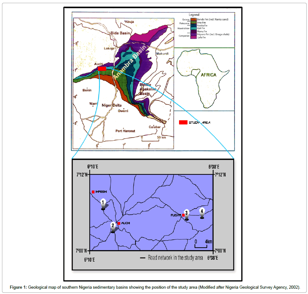
Figure 1: Geological map of southern Nigeria sedimentary basins showing the position of the study area (Modified after Nigeria Geological Survey Agency, 2002).
Regional Geologic Setting of Anambra Basin
The study area is part of the western flank of Anambra basin, a roughly triangular subbasin in the Southern Benue Trough of Nigeria.
The Benue Trough is a Cretaceous-Tertiary rift basin in Nigeria and is a part of the West Africa Rift System (WARS). The trough extends from the Niger Delta in the Atlantic coastal margins to Chad, Niger, and Sudan [4]. The Benue trough is similar to the Central Graben in the North Sea of Europe as they individually form extensive rift system through the entire Atlantic region. The trough is an elongate NE-SW trending rift basin with an approximate length of about 800 km [5]. It has a width of 130-150 km and is filled with sedimentary rocks ranging in age from Middle Aptian to Tertiary. The thickness of Cretaceous-Tertiary sediment filling the trough varies from about 6 km in the southern Benue Trough to about 5 km in the Northern Benue Trough. The trough contains numerous sub-basins including Anambra Basin. The evolution of the Benue Trough began with the rise of a mantle plume under the present-day Niger delta. This gave rise to doming and uplift of continental lithosphere, emplacement of mafic and possibly felsic igneous material, crustal thinning and subsequently rifting and the formation of a rift-rift-rift (rrr) triple junction which involved the Benue Trough, the South Atlantic and the Gulf of Guinea [5,6]. This event took place during Aptian to Albian times and was accompanied by the deposition of sediments of the Asu River Group and the eruption of alkaline mafic lavas and volcanoclastics as are found around Abakaliki [7].
The initial deposition of the Asu River Group was followed by the deposition of Odukpani Formation, Eze-Aku Group and Awgu Formation during the Albian-Coniancian interval. A major tectonic event in the mid Santonian caused structural inversion in the Southern Benue Trough. The orogeny which was accompanied by volcanism, folding, structural inversion, uplift and erosion, also resulted in downwarping of Anambra and Afikpo platforms which hitherto were thinly mud-draped, forming the Anambra basin and Afikpo Syncline to the west and east respectively of the Abakaliki Anticlinorium. Sedimentation in the newly formed Anambra Basin began with deposition of marine Nkporo Group in the Campanian during a period of marine transgression. The Nkporo Group is comprised of Nkporo Shale, Enugu Shale and Owelli Sandstone. This was followed by the deposition of Mamu, Ajali and Nsukka Formations during the regressive phase in the Maastrichtian. Another cycle of marine transgression-regression commencing at the beginning of the Tetiary led to the deposition of marine Imo Shale, Ameki, Ogwashi-Asaba and Benin Formation [8,9]. Sections of the Maastrichtian sediments outcrop in Auchi and Fugar areas (Figure 2).
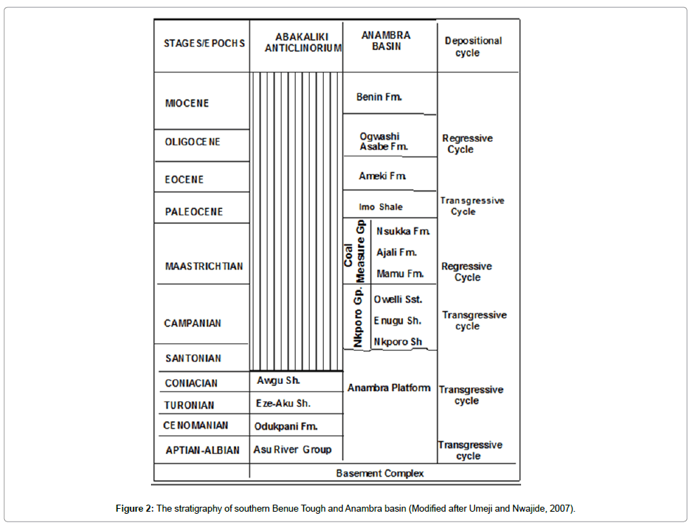
Figure 2: The stratigraphy of southern Benue Tough and Anambra basin (Modified after Umeji and Nwajide, 2007).
The lithologic characteristics of the lithostratigraphic units of the Nkporo Group have been described by numerous workers including [8,10-13]. The litho-facies associations of the Mamu Formation include sandstones and shales, with minor limestones in the southern part of the basin and coal horizons in the central and northern parts of the basin. The rocks of the formation display both vertical and lateral facies changes [14]. The depositional environments include estuary, distributary channels, barrier foot, swamp and tidal flats.
Ajali Formation, previously referred to as the False Bedded Sandstone was renamed Ajali Formation by Reyment. It consists mainly of medium- to coarse–grained, moderately sorted, burrowed, friable, quartzose sandstone. The sediments of Ajali contains kaolinite matrix that is rarely more than 5% of the total rock volume. It is typically white with large-scale occasionally clay-draped cross-beddings [9]. The sandstone is a coarsening upward sequence in places. Frequently it is cross-bedded and may contain thin interbeds of mudstone and numerous bands of variegated rarely carbonaceous shales and occasional plant impressions. At its type locality, the Nkalagu quarry outcrop near Nsukka, the formation is approximately 45 m thick [15]. The formation marks the peak of the regression at a time when the coastline was still concave. The formation is about 300 m thick extending across the entire basins as a sheet like sand body, and into the Middle Niger Basin. This formation was deposited mainly in the Anambra Basin and Afikpo Syncline. Its stratigraphic position, as well as field relations with the underlying Mamu and the overlying Nsukka Formation, is the criterion used by Simpson [11] for assigning a Maastrichtian age.
The Nsukka Formation (Upper Coal Measures) conformably overlies the Ajali Sandstone. It extends from the north of Awka to the northern Ankpa sub-basin. Its lithology is comprised mainly of interbedded shales, siltstones, sands and thin coal seams, which have become lateritized in several places where they characteristically form resistant capping on mesas and buttes. The formation is about 300 m thick extending across the entire basins as a sheet-like sand body. Its depositional environment has been suggested to be similar in many ways to the Mamu Formation (Lower Coal Measures), consisting of transitional/shoreline, mud flat and swamps, deposited during a largely regressive phase [15,16].
Research Methodology
Four stratigraphic outcrop sections were studied and measured for the purpose of identifying the various facies and producing vertical lithofacies logs. The sections are exposed by: the Auchi-Ibillo road cut near Meseme Army Barracks; the erosional river gulley in Auchi behind Union Bank Plc; the road cut on the eastern part of Fugar on the Fugar-Agenebode road; and the road cut on the Fugar-Agenebode road, situated about 2 km east of Fugar near Othamhe village. The study involved observation of outcrop sections first from a distance in order to get the general structural appearance. This was then followed by observations at close range. The coordinates of each outcrop location were determined by means of a Geographical Positioning System (GPS) and recorded. The GPS readings were then plotted on the topographic map in order to ascertain the actual location of outcrops. The study proceeded with determination of the area coverage of the outcrop, identification of lithology and bedding planes, observation of nature of bed contact, measurement of the thickness and lateral extent of beds as well as changes in bed thickness. Sedimentary structures were identified and mapped. The orientation and dip of directional sedimentary structures like cross stratification and climbing ripples were measured with compass clinometers and recorded. Rock samples were collected either from beds or at regular intervals where bed contacts were not visible (or where beds are too thick) with the aid of a chisel and geological hammer and kept in labeled sample bags. Visual examination of samples was done to identify mineral assemblages present, grain size, grain shape and sorting.
Results
The result of the facies analysis on four stratigraphic outcrop sections in the study area which constitutes part of the western flank of Anambra basin has led to the recognition of nine (9) lithofacies. The first outcrop is located on a coordinate of 070 07.224′ N and 0060129.380′ E. The stratigraphic section is a road cut located about 4 km NW of Auchi, along Auchi-Ikpeshi road and beside Meseme Army barracks. The outcrop is an embankment on both sides of the road. It stretches laterally for about 150 m and with an exposed stratigraphic thickness of about 15 m on both sides of the road (Figure 3). The cut is oriented roughly perpendicular to the direction of depositional dip. The overall shape of the exposure is lensoidal and it attains its maximum thickness of about 15 m near its middle portion. Delineation of beds was achieved based on variations in grain size and/or colour since bed contacts are gradational except for the erosional scour at the base of the conglomeratic bed. Sedimentary structures include pebble imbrications, normal graded bedding, planar cross lamination and large-scale trough cross bedding and lateral accretion surfaces. Bed contacts are gradational and are therefore difficult to trace for reasonable lateral distance. The azimuths of paleocurrent indicators measured on pebble imbrications and orientations of dip of cross stratification reveal that the directions of paleoflows are variable ranging from 970 to 1670 (Figure 4a) Four lithofacies are recognized in the stratigraphic section and are coded following [17] with some modifications to allow for detailed description of facies (Tables 1 and 2). They are: (i) medium-grained, moderately-sorted, planar cross laminated, milky white, quartzose sandstone facies (Sxl), (ii) Structured to massive conglomerate facies (Gmm), (iii) coarse-grained, large scale trough cross bedded, pinkish brown, quartzose, sandstone facies (St), and (iv) medium-grained, massive sandstone facies with accretion surfaces (Sm). Facies Sm contains streaks of mudstone lenses towards the top of the section. Facies Sxl occurs as single bed and is partially exposed. It upper bounding surface is a sharp erosional contact with the overlying matrix-supported conglomerate facies (Gmm). The clasts of the conglomerate are variable in size but generally range from 0.5 cm to 1.8 cm across and they are embedded in medium- to coarse-grained, sub-angular to sub-rounded, poorly sorted, quartzose sandstone matrix. The composition of the clasts is mainly granitic. These facies display normal graded bedding with some pebble imbrications at near the sole. Its basal contact has erosional relief of over 20 cm. the upper bounding surface is gradational but can be identified by change in grain size of the succeeding facies.
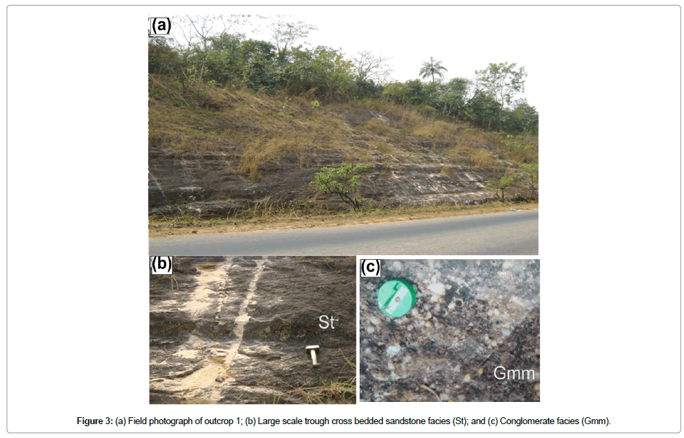
Figure 3: (a) Field photograph of outcrop 1; (b) Large scale trough cross bedded sandstone facies (St); and (c) Conglomerate facies (Gmm).
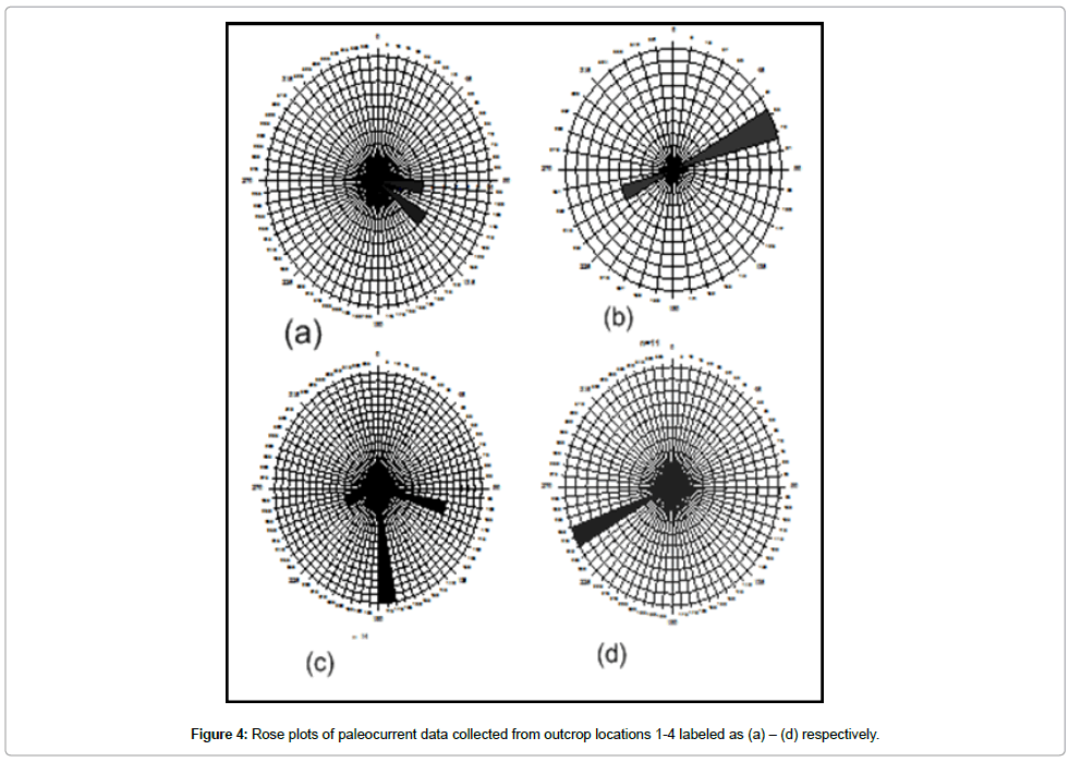
Figure 4: Rose plots of paleocurrent data collected from outcrop locations 1-4 labeled as (a) – (d) respectively.
| Facies | Auchi locality | Fugar locality | ||
|---|---|---|---|---|
| Outcrop 1 | Outcrop 2 | Outcrop 3 | Outcrop 4 | |
| Gmm | + | - | - | - |
| Sx | - | + | + | + |
| Sxb | - | - | + | - |
| Sxl | + | - | + | - |
| St | + | + | - | - |
| Sxh | - | + | - | - |
| Sh | - | + | - | - |
| Sr (Sc, Sw) | - | + | - | + |
| Sm | + | + | - | + |
Table 1: Facies occurrences in the four stratigraphic outcrop sections. (- means facies is absent; + means facies is present).
| Facies Code | Description of facies | Interpretation |
|---|---|---|
| Gmm | Imbricated to massive matrix-supported medium grained conglomerate with clasts ranging from 0.5 to 1.9 cm. The facies is normally graded. Thickness is up to 1 m. Clasts are composed of granite, subangular to sub- rounded. Base is erosional. The matrix is composed poorly sorted, medium to coarse-grand, mud-free quartzose sand. | High energy fluvial channel lag deposit resulting mainly from debris flow with subordinate traction process. |
| Sx | Thick bedded, fine- to medium-grained, moderately sorted, planar cross-bedded, friable, quartzone sandstone facies. Sx contains little amount of mud at location 4. Streaks of carbonaceous materials were observed on foresets and bedding planes in outcrop 3. | Deposit resulting from downstream migration of 2 D and 3 D dunes during unidirectional aqueous flow. |
| Sxb | Thick-bedded, Medium-grained, moderately-sorted, planar cross bedded, milky white or furuginized, quartzose sandstone facies with rashes of sub vertical Ophiomorpha burrows | Deposit resulting from downstream migration of 2 D and 3 D dunes during unidirectional aqueous followed by post depositional bioturbation |
| Sxl | Medium-grained, moderately-sorted, planar cross laminated, milky white or furuginized, quartzose sandstone facies. The beds are tabular or sheet-like and contacts are abrupt. Bed thicknesses are variable, ranging from 0.5 to 1. | Downstream subaqueous migration of 2D ripples during unidirectional stream flows |
| Sm | Very thick to thick bedded, coarse to medium-grained, massive, white sandstone facies with streaks of mudstones. Lateral accretion surfaces were observed at location 1. | Moderate fluvial energy bedforms formed as a result of gradual accumulation of sediment beneath steady or near steady flow.or fluidization of sand bodies under subaqueous condition. |
| St | Fine- to coarse-grained, trough cross bedded, white to pinkish brown, sandstone facies. Both large and small-scale trough beddings were recognized in outcrops 1 and 2 respectively. | Dunes (lower flow regime) |
| Sxh | Thick bedded, medium-grained, moderately sorted, herringbone cross stratified, reddish brown sandstone facies. Facies Sxh has mud draped forests in places and associated reactivation surfaces. Bed forms are lenticular and contacts are gradational. | Migration of subaqueous 2D and 3D dunes during ebb- and flood-tides in the upper shoreface. |
| Sh | Very thick bedded, fine-grained, moderately sorted, fine-grained, white hummocky cross stratified sandstone | Combined unidirectional and oscillatory flows during episodic storm events in shallow marine setting |
| Sr (Sw, Sr) | Medium-grained, moderately sorted, rippled sandstone. Both symmetrical and asymmetrical formed were observed in outcrops 2 and 4 respectively | Net deposition of sediment causing ripple migration during decelerating flows associated with river floods. |
Table 2: Description of facies in the various outcrop locations.
The second stratigraphic outcrop section located on coordinates of latitude 7003.372′ N and longitude 6015.261′ E is exposed by the NE-SW trending Orle River channel. The river flows south-westwards. The thickness of the exposed section is about 16 m. Five lithofacies were identified in the stratigraphic section on the basis of lithology, sedimentary structures and textural characteristics. From the bottom to the top, the facies are:
(i) Thick bedded, very fine-grained, moderately sorted, white hummocky cross stratified sandstone facies (Sh). This partially exposed basal unit consists of swales and is highly indurated with sparse subhorizontal burrows. The exposed part of the stratum attains a thickness of 1.2 m (Figure 5b). Its boundary is gradational;
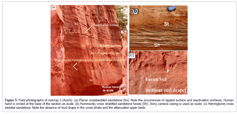
Figure 5: Field photographs of outcrop 2 (Auchi). (a) Planar crossbedded sandstone (Sx). Note the occurrences of rippled surface and reactivation surfaces. Human hand is circled at the base of the section as scale. (b) Hummocky cross stratified sandstone facies (Sh). Sony camera casing is used as scale. (c) Herringbone cross bedded sandstone. Note the absence of mud drape in the cross strata and the attenuated upper beds.
(ii) Medium bedded, fine-grained, small scale troughs cross bedded, sandstone facies (St);
(iii) Thick bedded, fine-grained, well sorted planar cross bedded, friable, white, sandstone facies (Sx). The foresets dip away from the horizontal surface of deposition at angles ranging from 280 to 350 with an azimuth of 0760. The thickness of the cross beds ranges between 5 cm and 7 cm and is delineated on the basis of colour variation. The facies occur at two stratigraphic levels. Reactivation surfaces are present in the upper section of the facies (Figures 4 and 6);
(iv) Thick bedded, red, medium-grained poorly to moderately sorted massive sandstone facies with indications of weak horizontal bedding (Sm). These facies occur at two stratigraphic levels.
(v) Medium-grained, poorly to moderately sorted, herringbone cross stratified, reddish brown sandstone facies (Sxh). Its boundaries with the other beds are for the most part gradational. These facies is the most dominant and occurs at the upper part of the section. The mineralogy of the framework grains of separate facies of the section is predominantly quartz which accounts for over 90 % or more of the grains. The sediments are mineralogically mature. The grain roundness ranges from subangular to rounded.
The third stratigraphic outcrop section is a road cut exposed along the Auchi-Agenebode road and is situated on the eastern side of Fugar town. Its GPS coordinates are 070 05.437′ N and 006030.915′ E. The orientation of the cut is roughly parallel to the depositional strike. The cumulative thickness of the exposed section is about 14 m and extends laterally for about 40 m on both sides of the road. The overall shape is lensoidal and it is composed of multi-story, conformable, tabular sets of planar cross stratified sandstone beds (Figure 6). Beds thicknesses range from thick to very thick, varying from about 1 m to over 2 m. Most of the beds maintain their lateral thickness while a few thin out. These set of conformable beds strikes E-W and dips gently south at about 060. Bed thicknesses decrease stratigraphically upward. Paleocurrent data obtained from the azimuths of dips of cross strata indicate that sediments were deposited mainly by southerly, south-westerly and southeasterly directed currents (Figure 4c).
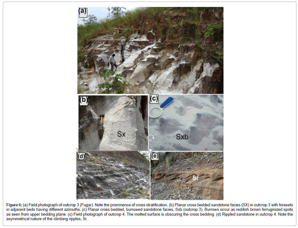
Figure 6: (a) Field photograph of outcrop 3 (Fugar). Note the prominence of cross stratification. (b) Planar cross bedded sandstone facies (SX) in outcrop 3 with foresets in adjacent beds having different azimuths. (c) Planar cross bedded, burrowed sandstone facies, Sxb (outcrop 3). Burrows occur as reddish brown ferruginized spots as seen from upper bedding plane. (c) Field photograph of outcrop 4. The molted surface is obscuring the cross bedding. (d) Rippled sandstone in outcrop 4. Note the asymmetrical nature of the climbing ripples, Sr.
Three lithofacies were identified in the section. They are:
(i) Medium-grained, moderately sorted, unbioturbated, white, friable, planar cross-bedded sandstone facies (Sx). These facies occurs at the bottom and middle part of the section and constitutes about 70 % of the exposed stratigraphic thickness,
(ii) Medium-grained, white, bioturbated, friable and planar sandstone facies Sxb) (Figures 6a-6d). These facies occur close to the bottom of the exposed section and is sandwiched within the former facies It contains a rash of nearly vertical Ophiomorpha burrows,
(iii) Medium-grained, pink- grey feruginized, poorly to moderately sorted, planer cross laminated tabular sandstone facies (Sxl). This lithofacies accounts for about 15 % of the entire stratigraphic thickness and occurs at the upper part of the section.
The fourth stratigraphic section located on coordinates of latitude 70 05.571′ N and longitude 6032.594′ E is exposed at a road cut along Fugar-Agenebode road and is about 2 East of Fugar. The outcrop is lensoidal and consists of tabular sets of white quartzose sandstone beds with subordinate clay matrix. The total stratigraphic thickness is 13 m and extends laterally for about 60 m. The entire outcrop has been mottled gray by exposure to surface conditions. Mean grain size show a slight fining upward trend. Bed contacts are abrupt. Three lithofacies were identified in this section. They are
(i) Medium to thick bedded, medium-grained, moderately sorted, planar cross-bedded, friable sandstone facies (Sx). The beds are tabular with thicknesses ranging from 0.7 to 2 m. This facies accounts for over 80 % of the entire stratigraphic thickness of the exposure. The cross beds consist of foresets that dip between 200 and 280 from the horizontal bedding planes. The azimuths of foresets dip range from 245 to 2560 and show very little temporal variations in the directions of paleoflow.
(ii) Medium-bedded, medium-grained, moderately sorted, massive, white sandstone facies (Sm). This facies occur as a single pinch out bed and is overlain by it.
(iii) Medium-grained, moderately sorted, rippled sandstone facies (Sc). The wavelength of the climbing ripple is about 35 cm and with lees directed south-westward.
Discussion on Facies Associations and Depositional Environments
The interpretation of depositional environment through analysis of lithofacies is based on the premise that vertical successions of facies is a product of facies that formed in laterally adjacent sub-environments of deposition which become stacked on top of each other due to lateral migration of environments. The result of the outcrop studies has led to the recognition of facies associations. Facies associations were defined based on bedding style, grain size, sedimentary structures and biota content. Depositional environments were interpreted from these facies associations. Five facies associations have been defined from the four stratigraphic outcrop sections. They are facies associations (FA) 1, 2, 3, 4 and 5.
Facies Association 1: Fluvial Channel Deposit
Facies association A is represented by facies Gmm, St, Sm and Sx. This facies association occurs in the first outcrop section which actually begins with the medium –grained, planar cross laminated, sandstone facies (Sx). The poor sorting of the massive matrix supported conglomerate facies (Gmm) suggests deposition by gravity flow, presumably by debris flow which may have resulted from sudden reduction in velocity of the sediment-carrying current [18,19]. The identification of channel (CH) architectural element that has erosional relief at the base of Gmm with a concave upward nature is characteristic of fluvial channel deposits [20]. Lithofacies (Gmm), however, diplays a few imbricated structure. The observed preferred orientations of prolate gravels which is visible from imbricated structure in the conglomerate facies is indicative of unidirectional flows. These features are typically showed by overlapped tabular and disc-shaped pebbles, whose long axes are parallel to the paleocurrent and dip in an upstream direction. Other paleocurrent data derived from azimuths of foreset dip in Sx together with those from imbricated structures show small variation in the direction of paleocurrents whch is characteristic of deposition in low sinuosity braided river [21]. The coarse-grained, poorly sorted, large scale trough cross bedded sandstone facies (St), the mediumto coarse-grained, massive sandstone facies with lateral accretion surfaces and lenses of mudstone (sm) represents channel fill deposits. According to Zieliǹski and Gozdzik, and Mode et al. [22,23], facies St and Sx usually form under strong, lower flow regime conditions such as in fluvial channels and wave-dominated beach environments. Facies Sm indicates rapid non-tractional dumping of sand from turbulent suspension due to episodic‘overcharging’ of the river current with sediment load.
This Facies association is similar to the one described by Uzoegbu et al., Selley and Oplustil et al. [17,19,20] for braided fluvial deposits. The coarse grain size of the deposits, the poor sorting nature, the fining upward trend, the absence of marine fossils, the gradational bedding contacts and minor occurrence of mud indicate deposits of braided fluvial system. Mode et al., and Raymond [23,24] have recognized the association of conglomeratic facies at the base of fluvial sequence, planar and trough cross-bedded facies, absence of marine fauna, presence of mudrocks facies at the top of sequence as well as finingupward character as criteria for recognizing channel deposit of a braided fluvial channel deposit. Moreover, the coarse grain nature of the sediments of outcrop suggests sediment deposition in a high energy environment. The fining upward stratigraphic grain-size trend reflects either a decrease in the energy of the environment of deposition or a slight increase in paleowater depth. The generally poor sorting of the sediments further corroborates its fluvial origin since, according to Miall [18], fluvial deposits are poorly sorted to moderately sorted. Miall [21] pointed out a number of recognizable textural differences between meandering and braided river deposits. According to these authors, meandering river alluvium is generally dominated by medium and fine sand, whereas the braided river alluvium consists of coarse and medium sands. They further stated that the relative amount of gravel and sandy gravel beds in the braided river alluvium is three to five times higher than in the meandering river alluvium, whereas the volumetric frequency of silt and silty sand beds is 10 times higher in the latter. In the light of the above, alongside the paucity of fine sand facies a braided fluvial origin is suggested for the sedimentary succession in outcrop 1.
Facies Association 2: Shoreface Deposit
Facies association 2 consists of three lithofacies: Sh, St and Sm. These facies are fine-grained hummocky cross bedded, creamy white sandstone facies (Sh), fine-grained, small scale trough cross bedded, creamy white sandstone facies (St), and the thin bedded, fine-grained massive sandstone facies (Sm), Facies Sh contains sparse sub-horizontal burrows of skolithos. The sediments of these facies are well sorted, subangular to subrounded, and quartz arenites. The sandy bodies are tabular and lenticular and the contacts between the beds are gradational (Figure 5). FA2 is restricted only to the lower part of the section at locality 2. The basal portion of the sequence (Auchi section) consists of partially exposed fine-grained, clean, well-sorted friable, quartzose hummocky cross stratified burrowed creamy white, sandstone facies (Sh). The hummocks consist of low angle (about 50) intersecting concavo-convex cross beds, similar to the type described by Umeji in Turonian Eze Aku Sandstone from Isikpuna in Anambra basin. The maximum exposed thickness of this facies 1.2 m (Figures 4 and 6).
HCS is interpreted as deposit of combined high unidirectional wave current and oscillatory flows and is believed to be formed by episodic storm activity and wave generated surges in lower-middle shoreface environment [25]. The trough cross bedded sandstone facies (St) is interpreted as being deposited in high energy environment where wave or current was constantly reworking sediment [26]. The absence of clay deposit in FA 2 suggests sediment deposition in an energetic environment capable of winnowing away clay-sized particles. According to Dalrymple, fine-grained, hummocky cross stratified sandstone facies is diagnostic of shallow marine storm sedimentation. Studies of HCS in Tertiary sedimentary successions in petroliferous Niger delta by Zieliǹski, Gozdzik and Eoff [22,27] led to the same conclusion that the structure is indicative of shallow marine shoreface sedimentation. Numerous other studies have affirmed that HCS form from net accumulation of fine sand under oscillatory or combined flows during waning phases of storms [25-28]. According to Buatois et al. [26], HCS has the highest preservation potential between fair-weather and storm wave bases and therefore an important tool for analyzing processes in ancient shallow marine environments. Buatois et al., [26] also stated that HCS is usually preserved, in vertical successions, between trough cross stratified sandstone (shoreface deposit) and offshore mudstone or turbidites and that the structure is most abundant in highstand system tracts.
Facies Association 3 (FA 3): Tidal Channel Deposit
FA 3 consists of three facies, Sx, Sxh and Sm. The planar cross bedded sandstone facies is the most prominent. It consists of thickly bedded, fine- to medium-grained, moderately sorted, white to reddish brown, friable, planar cross bedded, quartz sandstone (sx), Facies Sx passed stratigraphically upward into medium-grained, moderately sorted, reddish brown, friable, herringbone cross bedded, quartz sandstone (Sxh) with some foresets presenting mud drapes. The foresets of cross strata of Sxh display bipolar dip orientations. Facies Sxh is sandwiched in the thickly bedded, moderately sorted, fine- to medium grained, friable, reddish brown, massive, quartz sandstone (Sm). Other sedimentary structures observed in the section are symmetric ripple marks and reactivation surfaces (Figures 5a and 5b). The reactivation surfaces display observable discordance with adjacent beds. The structure appears as disconformities and is texturally distinct from adjacent beds.
The planar cross bedded sandstone facies (Sx) is believed to have been laid down from water current as a result of migration of sand waves and dunes in high energy environment. According to Raymond [24], these facies is not environment-diagnostic since it can form during deposition in deserts, rivers, deltas, lakes, beaches and even in shallow seas. It is presumed to have been deposited in tidally influenced fluvial channel because of its association with herringbone cross stratified sandstone facies. Reactivation surfaces may indicate unsteady to possibly reverse flow or truncation by wave action [14]. According to Mangano et al. [29], unsteady and reversing conditions and quiescent periods are characteristic of, but not exclusive to, tidal environments. Facies Sxh is characterized by bipolar dip directions of adjacent mud-draped cross beds and displays both symmetric and asymmetric limbs. Buynevich et al. [30], referring to Santos et al. [31] stated that coastal systems can be classified into two main types: wave dominated, and tide dominated. The occurrence of symmetric ripple mark is indicative of wave influence (Figure 5a). The herringbone cross bedding is attributed to deposition resulting from migration of current ripples and dunes during flood and ebb tides which produce dominant and subordinate currents respectively oriented NE-SW and normal to coastline [14,32]. The symmetric herringbone cross beds suggest ebb and flood currents of approximately equal energy, whereas the asymmetric type indicates stronger flood current energy. According to Uzoegbu [17], the asymmetrical nature of the deposit resulting from a tidal cycle may suggest a net direction of sediment transport during an ebb-flood cycle and is possibly the result of unequal energies of the ebb and flood currents. Herringbone cross stratatification with mud draped attenuated foresets suggests deposition during neap tide when the tidal range is about 30 % less than the mean tidal range. According to Plink-Bjorklund [33], neap tide is characterized by weak ebb-flood tidal energy that permits clay to settle on foreset bedding planes as current velocity approaches zero at high and low tides.
Facies Association 4: Delta Front Deposit (Distributary Mouth Bar)
Facies association 4 consists of three lithofacies namely, Sx, Sxl and Sxb. Facies Sx is medium-grained, moderately sorted, creamy white, planar cross bedded sandstone. Sxl is laminated, reddish brown, ferrugenised, planar cross laminated sandstone facies, and Sxb is medium-grained, moderately sorted, creamy white, planar cross bedded sandstone with burrows. Facies association 4 occurs in outcrop 3 (Fugar section). The grains are subangular to subrounded and predominantly quartz. Bed thicknesses range between 0.5 m to 1.6 m and decreases up section. The beds are dipping gently southerly at 100 in the direction of sediment transport. Nearly all the beds are tabular apart from one wedge. The azimuths of foresets of cross strata dip in different directions ranging from SE through W to SE (Figures 5, 6 and 7c). Bed contacts are sharp or distinct. There is presence of thin streaks of coal on bedding planes. The ichnofossils in facies Sxb consists of sub vertical Ophiomorpha burrows which are lined with ferruginized mud.
The medium-grained nature of FA 4 is indicative of deposition in a high energy environment. The distinct bed contact indicates breaks in sedimentation events. The upward transition from cross bedded sandstone facies to cross laminated sandstone facies together with upward decrease in bed thickness is suggestive of gradual reduction in flow velocities. The streak of coal between the bedding planes is indicative of aqueous condition. The sedimentary deposit in outcrop 3 occur as tabular sets of cross stratified quartzose sandstone facies and according to Tape et al. [34] tabular sets of cross-strata are deposited by migrating sand ripples, sand waves or dunes. Sand ripples, waves and dunes are common on the beds of rivers, tidal flats and channels. Cross-stratification is primarily formed as a result of deposition during the down current/wind migration of ripples, sand waves and dunes. Mode et al. and Raymond [23,24] indicated that tabular sets of crossstrata with planar configuration and presence of non-marine fossils is suggestive of an environment with high rate of siliciclastic input. The presence of carbonate cement is probably in favour of continental settings. However, the presence of Ophiomorpha burrows in the lower part of the sequence and the occurrence of beds with azimuths of foresets dip in directly opposite direction to the major paleocurrent trend may indicate occasional marine incursion or flooding leading to a reversal of current flow direction. The cross laminated facies are indicative of slight intermittent variations in the energy of the depositional environment. The presence of Ophiomorpha burrows indicates oxic shallow marine condition and a slow rate of deposition. According to Tape et al. [34], Ophiomorpha burrows are produced by Crustaceans and may be indicative of shallow marine shelf environment. Restriction of these burrows to a particular stratigraphic horizon of the profile may suggest sporadic incursion of marine condition. The inclined nature of the beds towards the direction of depositional dip indicates deposition from a point source in the updip direction. This relationship is consistent with deposition associated with distributary mouth bars in delta-front environment. Mouth bar deposits usually are clean sands and exhibit tabular geometry.
Facies Association 5: Distributary Channel Deposit
Facies association 5 (FA 5) consists of facies Sx, Sm and Sr. The Sp facies is the dominant facies in location 4 and it is medium to thick bedded, medium-grained, moderately sorted, planar cross-bedded, creamy white, quartz sandstone facies (Sx. It occurs as tabular beds with thicknesses ranging between 0.7 and 2 m. it contains minor amount of clay. Facies Sm occurs as a single wedge. It is a medium bedded, moderately sorted, creamy white, quartz sandstone sandwiched in Sx. Facies Sr occurs at the top of the section (Figure 6f). It consists of medium-grained, moderately sorted cream white to brown, rippled quartz sandstone. The length of the ripple is up to 30 cm. There is a slight variation in the paleocurrent directions from 245 to 2560 in the stratigraphic section.
The association of facies Sx, Sm and Sr at location four is interpreted as stacked distributary channel deposit. The outcrop of this locality is characterized by tabular sets of planar cross bedded sandstone as well as climbing ripples. Planar cross beds are formed by down- current migration of sand dunes and mega-ripples. The structure can form in fluvial environment but may also form in many other sedimentary environments like tidal or beach environment. The absence of fossils as well as the presence of unidirectional paleocurrent pattern strongly suggests continental origin. Deposit of FA 5 is interpreted as stormflood deposition associated with times of high discharge by the feeding main streams (Figure 7).

Figure 7: Lithology logs of the four sedimentary outcrop sections (1-4) labeled (a-d). Note the temporal distribution of facies. Facies codes are explained in the text.
Conclusion
Lithofacies analysis of four sedimentary outcrop sections on the western flank of Anambra basin has led to the recognition of nine facies namely, structured to massive conglomerate facies (Gmm), fine- to medium-grained, planar cross bedded, sandstone facies (Sx), thickbedded, medium-grained, moderately-sorted, sandstone facies with rashes of sub vertical Ophiomorpha burrows (Sxb), medium-grained, moderately-sorted, planar cross laminated, quartzose sandstone facies (Sxl), coarse to medium-grained, massive, sandstone facies (Sm), fineto coarse-grained, trough cross bedded, quartzose, sandstone facies (St), medium-grained, moderately sorted, herringbone cross stratified, reddish brown sandstone facies (Sxh), fine-grained, moderately sorted, fine-grained, white hummocky cross stratified sandstone facies (Sh), and medium-grained, moderately sorted, rippled sandstone facies (Sr). The spaciotemporal examination of these facies allowed the identification of five facies associations (FAs). The facies associations are FA 1, FA 2, FA 3, FA 4 and FA 5. FA 1 is interpreted as channel deposit in braided fluvial system on account of the fining upward of trend, poor sorting, absence of marine fossils, narrow range of paleocurrent directions, amongst other things. FA 2 represents deposition in lower to upper shoreface because of the occurrence of fine grained, hummocky cross stratified sandstone facies in association with finegrained, small scale trough cross bedded sandstone facies. Gradational contact is characteristic of such facies association and is typical of shoreface. According to Buynevich et al. [30], the base level affected by fair-weather waves as proposed by Tape et al. [34] is the lower limit of the upper shoreface. The formation of FA 2 (Sh, St and Sm) most likely therefore represent deposition in shallow marine lower to upper shoreface. The association of facies Sxh, Sm and Sx (FA 3) is indicative of deposition in tidal channel. Herringbone cross bedding is formed tidal flats or tidally influenced fluvial channels due to the migration of sand ripples and dunes in response to flood and ebb tides. This view is further strengthened by the occurrence of reactivation surface. The presence of symmetrical wave ripples indicates wave influence. FA 4 which is composed of facies Sx, Sxb and Sxl is interpreted as distributary mouth bar deposition on account of the tabular bedform, fan-shaped paleocurrent signature and occurrence of mud-free clean sands. The association of facies Sx, Sm and Sr (FA 5) in outcrop four is interpreted as stacked distributary channel deposit. Therefore, sedimentation in the study area for the studied stratigraphic interval occurred in transitional fluvio-deltaic to shallow marine shoreface setting.
References
- Oronsaye WI (1987) Origin and depositional environments of the sandstone deposits in Fugar area. J Min Geol 23: 89-96.
- Allen PA, Armitage JJ (2012) Cratonic basins. In: Busby C, Perez AA (Eds) Tectonics of sedimentary basins: Recent advances. Wiley-Blackwell 602-620.
- Timms NE, Olierook HKH, Wilson MEJ, Piane CD, Hamilton PJ, et al. (2015) Sedimentary facies analysis, mineralogy and diagenesis of the Mesozoic aquifers of the central Perth Basin, Western Australia. Marine and Petroleum Geology 60: 54-78.
- Akande SO, Viczian I, Erdtmann BD (2005) Prediction of petroleum generation intervals in the southern Nigerian rift basins by means of clay transformations, vitrinite reflectance and fluid inclusion studies. NAPE Bull 18: 38-51.
- Burke K, Dessauvagie TFJ, Whiteman AJ (1972) Geological history of the Benue valley and adjacent areas. In: Dessauvagie TFJ and Whiteman AJ (eds). African Geology 187-218.
- Burke KC (1996) The African Plate. South Afri Journal of Geology 99: 341-409.
- Ofoegbu CO (1984) A model for the tectonic evolution of the Benue Trough of Nigeria. Geologische Rundschau 73: 1007-1018.
- Uzuakpunwa AB (1974) The Abakaliki pyroclastics, Eastern Nigeria: New age and tectonic implications. Geol Ma III 65-70.
- Nwajide CS, Reijers TJA (1996) Sequence architecture in outcrops: Examples from the Anambra. NAPE Bull 11: 23-33.
- Umeji OP, Nwajide CS (2007) Age control and designation of the standard stratotype of Nsukka Formation of Anambra Basin, southeastern Nigeria. J Min Geol 43: 147-166.
- Simpson R (1955) The Nigeria coal fields: The geology of parts of Owerri and Benue provinces. Geol Surv 24: 83-86.
- Reyment RA (1965) Aspects of the Geology of Nigeria. Ibadan University Press, Ibadan, Nigeria. p: 145.
- Obi GC, Okogbue CO, Nwajide CS (2001) Evolution of the Enugu Cuesta: A tectonically driven erosional process. Global Journal of Pure and Applied Sciences 7: 321-330
- Oboh-Ikuenobe FE, Obi CG, Jaramillo CA (2005) Lithofacies, palynofacies, and sequence stratigraphy of Paleocene strata in southeastern Nigeria. J Afri Earth Sciences 41: 79-101
- Dalrymple RW (1992) Tidal depositional systems. In: RG Walker and NP James (Eds) Facies models. Response to sea level change: Waterloo Geological Association of Canada 2: 195-218.
- Amajor LC (1984) Sedimentary facies analysis of the Ajali Sandstone (Upper Cretaceous), Southern Benue Trough. J Min Geol 21: 171-177.
- Uzoegbu UM, Uchebo UA, Okafor I (2013) Lithostratigraphy of the Maastrictian Nsukka Formation in the Anambra Basin. J Environmental Sci 5: 96-102.
- Miall AD (1996) The geology of fluvial deposits: Sedimentary facies, basin analysis, and petroleum geology. Springer-Verlag, Berlin, Germany. p: 582.
- Oplustil S, Martinek K, Tasaryova Z (2005) Facies and architectural analysis of fluvial deposit of the Nyrany Member and the Tynec Formation (Westphalian D-Barruelian) in the Waduo-Rakovnik and Pilsen basins. Bull of Geosciences 80: 45-66.
- Miall AD (2014). Fluvial depositional systems (1sted). Springer Int Pub, Germany. p: 316.
- Zieliǹski T, Gozdzik J (2001) Palaeoenvironmental interpretation of a Pleistocene alluvial succession in central Poland: Sedimentary facies analysis as a tool for palaeoclimatic inferences Boreas 30: 240-253.
- Mode AW, Anyiam OA, Omuije JO (2014) Analysis of sedimentary facies and paleo- depositional environments of the DC70X reservoir in Mbakan field of the central swamp, Niger Delta. Springer-verlag 1866: 7538.
- Raymond LA (1995) Petrology: The study of Igneous, Sedimentary, Metamorphic rocks. Wm C Brown Pub 742.
- Roberts EM (2007) Facies architecture and depositional environments of the Upper Cretaceous Kaiparowits Formation, Southern Utah. Sedim Geol 197: 207-233
- Buatois LA, Zeballo FJ, Albanesi GL, Ortega G, Vaccari NE, et al. (2006). Depositional environments and stratigraphy of the Upper Cambrian-Lower Ordovician Santa Rosita Formation at the Alfarcito area, Cordillera Oriental, Argentina: Integration of biostratigraphic data within a sequence stratigraphic framework. Latin American J Sedimentology and Basin Analysis. 13: 1-29.
- Eoff JD (2014) Sedimentary facies of the upper Cambrian (Furongian; Jiangshanian and Sunwaptan) Tunnel City Group, Upper Mississippi Valley: New insight on the old stormy debate. Sedimentary Geology. 302: 102-121.
- Bassey CE, Ebuta AN, Ulu OK (2007) Sedimentological and paleogeographical studies of Dibi- 5 Core, Dibi Field. Global J Geological Sciences 5: 1-11.
- Mangano MG, Buatois LA, Guinea M (2005) Ichnology of the Alfarcito Member (Santa Rosita Formation) of northwest Argentina; Animal-substrate interactions in a Lower Paleozoic wave-dominated shallow sea. Ameghiniana 42: 641-668.
- Buynevich J, Bitinas A, Pupienis D (2007) Reactivation of coastal dunes documented by subsurface imaging of the Great Dune Ridge. Journal of Coastal Research 226-230.
- Santos MN, Chemale JF, Dussin IA, Martins MS, Queiroga G, et al. (2015) Provenance and paleogeographic reconstruction of a mesoproterozoic intracratonic sag basin. Sedim Geol 318: 40-57.
- Anthony EJ, Orford JD (2002) Between wave- and tide-dominated coasts: the middleground revisited. J Coast Res Spec. 36: 8-15.
- Plink-Bjorklund P (2005) Stacked fluvial and tide-dominated estuarine deposits in high-frequency (fourth-order) sequences of the Eocene Central Basin, Spitsbergen. Sedimentology 52: 391-428.
- Tape CH, Cowan CA, Runkel AC (2003) Tidal bundle sequences in the Jordan Sandstone (Upper Cretaceous), Southwestern Minnesota, USA: Evidence for tides along inboard shorelines of the Sauk Epicontinental Seas. Journal of Sedimentary Research 73: 354-366.
Citation: Ogbahon, Opeloye SA (2018) Depositional Environment of Siliciclastic Deposits on the Western Flank of the Anambra Basin, South West Nigeria: Insights from Sedimentary Facies Analysis. J Earth Sci Clim Change 9:471. DOI: 10.4172/2157-7617.1000471
Copyright: ©2018 Ogbahon, et al. This is an open-access article distributed under the terms of the Creative Commons Attribution License, which permits unrestricted use, distribution, and reproduction in any medium, provided the original author and source are credited.
Select your language of interest to view the total content in your interested language
Share This Article
Recommended Journals
Open Access Journals
Article Tools
Article Usage
- Total views: 27747
- [From(publication date): 0-2018 - Oct 23, 2025]
- Breakdown by view type
- HTML page views: 26673
- PDF downloads: 1074