The Assessment of the Wind Power Potential of the Territory at the Regional Level in Rio Grande Do Norte State, Brazil
Received: 01-Apr-2018 / Accepted Date: 16-Apr-2018 / Published Date: 24-Apr-2018 DOI: 10.4172/2157-7617.1000464
Abstract
The article is dedicated to the assessment of the wind power potential of the territory at the regional level. Such assessment allows defining a strategy of wind power development at administrative unit scale of the country. For Brazil and Rio Grande do N
Keywords: Wind power; Wind power potential; Wind power resources; Brazil; Rio Grande Do Norte
Introduction
The assessment of the wind power potential of the territory at the regional level allows defining the strategy of the wind power development at the level of administrative-territorial unit of the country. The objective of this research is to classify wind power potential of the territory by considering not only wind power resources, but such factors as land use, existing regional infrastructure and wind turbine technical characteristics too. Any examples of such research didn’t find in the present science world, the methodology of this research is the unique development of the author.
In Brazil wind power is actively developing despite the dominant fossil fuel sector which provides an important part of exports. During 2015-2016 average annual growth of total installed capacity of wind power in Brazil was 30%. Total capacity in 2016 have reached 965 GW, total electricity generation was 206 TWh compiling 38% of total electricity generation in the country [1].
In 2015, Brazil’s government adopted Energetics Financing Program (Programa de Investimento em Energia Electrica, PIEE) which was published to familiarize investors with the energetics financing plan for the coming years. According to the Program, total amount of energetics financing is $29 billion distributed to the energy projects with total capacity of 25-32 GW. 10-14 GW allocated for solar, wind and bioenergy projects, 4-6 GW allocated for wind power for the period 2015-2018. The adoption of this program gives a guarantee of renewable energy development for the near future. Brazilians hope to reach total capacity of wind power of 188 GW in 2019 at an average annual growth of 20% per year [2]. Also, during 2015, in Brazil was adopted an amount of laws relating to the wind power regulation, tax credits, air traffic safety regulations, transport logistics, power plant construction near archeological objects and new rules for improving network procedures.
Wind power has broad public support which is connected with the increase in income of the population and the economic growth of the country. But at the present time Brazil is in an economic crisis which calls into question the implementation of the adopted programs including the programs on the part of renewable energy and wind power development. It remains unclear whether and how Brazilian Development Bank (BNDES) will support the financing of the wind projects. One of the main obstacles for the wind power development in Brazil is lack of power lines in the regions with high wind power potential [2]. In April, 2016 in Brazil was held the tender for new power lines construction contracts. As the result of the tender, contracts were signed for the construction of more than 3000 km of power lines.
For the assessment of the wind power potential at the regional level was chosen Brazilian state of Rio Grande do Norte, because the territory of this state has the highest wind power potential per unit of territory in Brazil (74 m/s while the average of the country is 45 m/s), the state is first by volume of installed wind power capacity in the country (3024 MW) [2].
Rio Grande do Norte state is on the border of tropical dry and semiarid climates. A larger territory of the state is affected by a change in the dry and wet seasons – summer equatorial (equatorial monsoon) and winter tropical (tropical monsoon) air masses [3,4]. The longest dry season lasts in the central part of the state – annual precipitation hardly exceeds 400 mm. At the same time only 100 km to the east, on the Atlantic coast in the zone of influence of the western periphery of oceanic anticyclones, annual precipitation reaches 1500 mm [3]. This difference is due to the inertial flow of air masses from south to north along the eastern coast of Brazil, held back south of the ledge of the Brazilian Highlands, which in the north, in the Rio Grande do Norte, fades, as the highest point of the state is in the south central part of the state, 200 km from the east coast, in the ridge of Santa das Queimadas, and is only 800 m above sea level. The combination of all these conditions forms a unique distribution of the main wind directions in the state (Figure 1).
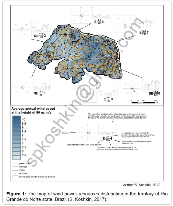
Figure 1: The map of wind power resources distribution in the territory of Rio Grande do Norte state, Brazil (S. Koshkin, 2017).
The result of the fact that Rio Grande do Norte is on the border of climatic zones has become a variety of types of vegetation. Most of the state is occupied by Caatinga, the north coast is occupied by dunes, floodplains of large rivers are occupied by floodplain forests and meadows, and the east coast is occupied by rainforests [5]. Decoding of space images to the territory of the research showed that the east coast no longer represents a forest area and is mainly occupied by arable land and populated areas. Forest sites, for the most part, are concentrated on the north coast.
Research Methodology
Rio Grande do Norte state is located at the east of Brazil where the coastline of the South American continent changes the south-east-east direction to the south. In this research were used different methods of geoinformation mapping. Resulting maps were created by the stepby- step introduction to the GIS application. Current infrastructure of Rio Grande does Norte state was borrowed from Open Street Map and (power lines) from the Atlas of Wind Power Potential of Rio Grande do Norte [6]. Determination of surface types occurred through manual and automatic with manual classification decoding of Digital Globe space images with a resolution of 1 m. Value field of the average annual wind speed at the height of 80 m is obtained through digitization by interpolation by the method of Natural Neighbor of the map of the average annual wind speed at the height of 80 m in Brazil [7]. Wind speed and wind direction data were taken from Gismeteo site [8]. Recalculation of the wind speed at the altitude of the windmill anemometer to the height of the wind turbine was carried out according to formulas:
U=Ua·Kh (1)
Where,
U – Wind speed at the height of the wind turbine,
Ua – Wind speed at the height of the anemometer,
Kh – Height adjustment factor),
Kh=(H/ha)m (2)
Where,
H – Wind turbine height,
ha – Anemometer height,
m – The exponent received depending on the wind speed at the height of the anemometer [9].
Results and Discussion
According to Figure 1, significant part of Rio Grande do Norte territory has very good wind power resources (with average annual wind speed 7-9 m/s) – it is Santa da Santana ridge in the center of the state, Santa do Carmo ridge in the north-west, Santa do Feiticeiro ridge in the north-east, San Vicente ridge in the south-west and Santa das Queimadas in the south. The rest part of the state has good and sufficient wind power resources and only some territories (like individual sites of Apodi, Parau and Piranhas basins) have inadequate wind power resources.
However, average annual wind speed of the territory parameter includes winds of all directions and as is known wind turbines have only one direction of rotation. In this way it is necessary to consider how winds are distributed by direction and speed. Using the daily data of wind speed and direction from Rio Grande do Norte weather stations from Gismeteo site we made the appropriate calculations and composed the wind roses. After the determination of dominant wind direction were calculated such parameters as the amount of days and the average daily speed of wind of dominant direction (Figure 1) in terms of the height of the anemometer to the height of the wind turbine. Distribution chart of the winds of the dominant direction allows seeing the distribution of wind power resources of the area during the year.
It is worth noting that during the calculations were taken into account technical characteristics of wind turbines with 80 m height. As a basis we took wind turbine Gamesa G80/2000 – this wind turbine is most common in Brazil [2]. As the wind speed with which this wind turbine begin to generate electricity is 35 m/s, during the calculations of the amount of days and the average daily wind speed weren’t taken into account the days with average daily wind speed of 35 m/s and less, because these days electricity generation is extremely difficult – either the turbine doesn’t work, either it constantly passes through on and off stages.
So our calculations from (1) and (2) the item show that after the determination of wind power resources of the winds of the dominant direction the situation has changed. The greatest wind power resources are concentrated in the south-east of the state – here are present stable south-east winds with the speed of more than 14 m/s during the larger part of the year, nearly 250 days of the year. These winds reach their greatest power from July to October.
Also perspective situation for the electricity generation at wind turbines develops in the north-east of the state – here are present south winds with the speed of nearly 11 m/s during 230 days of the year. Good conditions are seen in the south of the state on high ground (east winds with the speed of 10.1 m/s during 152 days of the year) and in the west of the state in Apodi basin (north-east winds with the speed of 11.2 m/s during 168 days of the year) (Figure 1).
Wind turbines generate electricity in the certain wind speed range, from 3-4 to 25-30 m/s. To take into account the fact that the result of the average daily wind speed can also include moments with a wind speed above 25-30 m/s we calculated the amount of days with storms since this weather phenomenon is characterized by strong gusts of wind. From (Figure 1) we see, that the presence of thunderstorms during the year is not typical for the south-east of Rio Grande do Norte where the greatest wind power potential. The reverse situation is observed in the north-east of the state where a part of wind power resources can be lost in view of too much gusts during the thunderstorms that happen in this area.
The next question is the possibility to place wind turbines on the territory. This possibility depends on what is on the site and what is the slope of the surface. The largest part of Rio Grande do Norte is occupied by meadows and shrubs. Further by the area there is the arable land in the north and the east of the state and the territories without vegetation in the north. All this is beneficial for wind power as such territories are most suitable for an accommodation of wind turbines in the absence of obstacles to the movement of air masses along the earth's surface. Forested areas are very rare in the territory of Rio Grande do Norte - they are found only along the northern coast of the state and at its southern borders.
Another factor that affects wind turbine installation is the actual possibility of installation, the presence of the customer. This requires proximity either directly to the consumer, or to power lines. The main part of power lines are confined to human settlements concentrating in the east of the state. But it cross the entire state territory which allows to develop wind power almost everywhere in Rio Grande do Norte (Figure 1). The main part of existing wind farms is located in the northeast of the state [2] where as we found out earlier are large perspectives for wind power development due to constant and strong south winds.
To take into account the earth’s surface of the territory, surface slope and existing infrastructure of the state we created the map of the classes of wind power resources of the researched area (Figure 2). Here are taken into account all the factors with the exception of certain previously dominant wind directions and its power because this parameter is not amenable to area mapping. But we used this parameter further for the final characterization of wind power resources of the state and the determination of the territories of main development prospects. To create this map we used a number of parameters (Figure 2). In Brazil there are norms of noise pollution. As wind turbines render noise we calculated the distance at which the noise from the wind turbine corresponds to the norms of noise pollution (30 dB, the standard NBR10152) – such distance for wind turbines with the height of 80 m [10] is 1250 m.
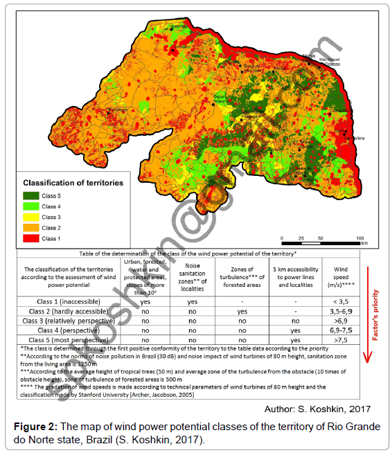
Figure 2: The map of wind power potential classes of the territory of Rio Grande do Norte state, Brazil (S. Koshkin, 2017).
Another parameter which we took into account is the turbulence from physical obstacles. According to the research [11], the zone of turbulence from the obstacle is 10 times of its height. The main obstacles to air masses on the ground are buildings and trees. Urban outskirts are characterized by one- and two-story houses, with a height of up to 10 m, with a corresponding zone of turbulence up to 100 m, which is less than the "sanitary" zones of localities that we calculated earlier. Thus, it remains to calculate the zone of turbulence of forested areas. The average height of tropical trees is 50 m [12]; therefore, its zone of turbulence is 500 m.
According to Figure 2, the territories with the most suitable conditions for wind power development are located in the east part of the state. Here exists the best combination of the factors – high average annual wind speed (and constant average daily wind speed of southeast and south direction as we found out earlier), the presence of the customer (localities) and corresponding infrastructure (power lines) and dominant meadows, shrubs and arable land with the small forest area participation. The south of the state is widely available for wind power development too. Also the north-west of Rio Grande do Norte is available but there are no constant strong winds of one direction (southeast winds are replacing by east and north-east winds), therefore, high prospects of this territory is in question. West and south-west territory of the state refers to hardly accessible territories, but we remember that in the west of the state are present stable north-west winds which compensates total amount of average annual wind speed and allows considering this area as perspective for the wind power development.
Conclusions
This research shows that
• in the presence of appropriate materials, a detailed study of the wind energy potential of the territories is possible to develop a strategy for the development of wind power at the regional level;
• the main factors which contribute to wind power development are high rates of wind speed with the domination of one wind direction, the presence of the customer and power lines;
• the main factors which prevent wind power development are low rates of wind speed and the absence of the winds of one direction and widespread forested areas;
• in Rio Grande do Norte state exist wide perspectives for wind power development especially in the east of the state where all the necessary factors are combined – constant and strong winds of one direction, the absence of large forested areas and water bodies preventing the placement of onshore wind farms, the customer and power lines.
References
- Associacao Brasileira de Energia Eolica (2016) Boletim de Dados, April 2016.
- Лукашова ЕР(1958) Ð®Ð¶Ð½Ð°Ñ Ðмерика ФизичеÑÐºÐ°Ñ Ð³ÐµÐ¾Ð³Ñ€Ð°Ñ„Ð¸Ñ [Book]. - МоÑква : Учпедгиз.
- IDEMA (2002) Tipos de vegetacao encontrados nas diferentas areas geograficas do Rio Grande do Norte [Online]. Instituto de Desenvolvimento Econômico e Meio Ambiente do Rio Grande do Norte.
- COSERN Atlas (2003) Do Potencial Eolico do Estado do Rio Grande do Norte.
- Elistratov VV, Kuznecov MV (2003) Theoretical foundations of unconventional and renewable energy. St Petersburg Publishing house of SPbSTU.
- Centre for alternative technology  (2017) CAT: Where should I put a wind turbine?.
- Lukashova EN (1958) South America. Physical Geography Moscow Uchpedgiz.
Citation: Koshkin SP (2018) The Assessment of the Wind Power Potential of the Territory at the Regional Level in Rio Grande Do Norte State, Brazil. J Earth Sci Clim Change 9: 464. DOI: 10.4172/2157-7617.1000464
Copyright: © 2018 Koshkin SP. This is an open-access article distributed under the terms of the Creative Commons Attribution License, which permits unrestricted use, distribution, and reproduction in any medium, provided the original author and source are credited.
Select your language of interest to view the total content in your interested language
Share This Article
Recommended Journals
Open Access Journals
Article Tools
Article Usage
- Total views: 4373
- [From(publication date): 0-2018 - Sep 02, 2025]
- Breakdown by view type
- HTML page views: 3487
- PDF downloads: 886