Research Article Open Access
Post-Remediation Assessment of Crude Oil Polluted Site at Kegbara-Dere Community, Gokana L.G.A. of Rivers State, Nigeria
| Tanee FBG* and E Albert | |
| Department of Plant Science and Biotechnology, Faculty of Science, University of Port Harcourt, Rivers State, Nigeria | |
| Corresponding Author : | Dr. Tanee FBG Department of Plant Science and Biotechnology Faculty of Science, University of Port Harcourt Rivers State, Nigeria E-mail: tanee_3030@yahoo.com |
| Received July 2, 2011; Accepted July 22, 2011; Published July 24, 2011 | |
| Citation: Tanee FBG, Albert E (2011) Post-Remediation Assessment of Crude Oil Polluted Site at Kegbara-Dere Community, Gokana L.G.A. of Rivers State, Nigeria. J Bioremed Biodegrad 2:122. doi:10.4172/2155-6199.1000122 | |
| Copyright: © 2011 Tanee FBG. This is an open-access article distributed under the terms of the Creative Commons Attribution License, which permits unrestricted use, distribution, and reproduction in any medium, provided the original author and source are credited. | |
Related article at Pubmed Pubmed  Scholar Google Scholar Google |
|
Visit for more related articles at Journal of Bioremediation & Biodegradation
Abstract
Post-remediation assessments of crude oil polluted sites at Kegbara-Dere community in Gokana Local Government Area of Rivers State, Nigeria were carried out to ascertain the degree of success of remediation work done by SPDC in the area in 2008. Soil samples were collected from 3 sites within the location viz; crude oil polluted unremediated site (A), crude oil polluted remediated site (B) and a control site of no pollution and remediation (C). Soil samples were collected at 3 soil depth levels of 0-5cm, 10-15cm and 20-25cm using soil auger and analysed for soil , conductivity, phosphate, nitrate, total organic carbon (TOC), total hydrocarbon content(THC) and total exchangeable cations (TEC). Soil pH and conductivity were obtained with a pH meter (Hanna Hi 8314) and conductivity meter (HACH Ecttesr microprocessor series) respectively. Total hydrocarbon content was measured by spectrophotometric method; total organic carbon content by oxidation method; nitrate content by Kjeldahl method, Phosphate content by ascorbic acid method and total exchangeable cations (Na + , K + , Mg 2+ and Ca 2+ ) by Atomic Absorption Spectrophometer method (AAS). Result showed no significant difference in the soil pH between and within sites. Soil conductivity, nitrate and phosphate improved significantly in the remediated site than the unremediated site. There was a drastic reduction in the total hydrocarbon content (THC) in the remediated site with the highest value of 100 mg/kg as against 350 mg/kg in the unremediated site. Total organic carbon (TOC) fluctuated between and within the 3 sites in the range of 3.63 - 4.11%. Ca 2+ was undetected in the remediated site especially at the 20- 25cm soil depth. This is an indication that the remediation carried out was successful.
| Keywords |
| Post remediation; Crude oil; Soil; Kegbara-Dere; SPDC; Ogoni; Soil nutrients |
| Introduction |
| Ogoni is a distinct ethnic nationality in the Niger Delta with an estimated population of about 850,000 people and occupies a land area approximately 1000 km². This people have lived in the area for more than 500 years and are engaged in fishing and farming as their main traditional occupations. Ogoni land as a component of the Niger Delta region is richly endowed with massive crude oil reserve which was first discovered at Bomu in Gokana Local Government Area in 1958 after Oloibiri by Shell Petroleum Development Company (SPDC). United Nation Environmental Programme [UNEP] [1] reports disclosed that SPDC operates 12 oil fields containing 116 drilled oil wells and has built 5 oil flow stations which bring total oil facilities in the area to 138 with total flow station capacity of 185,000 barrels of crude oil per day. With all these facilities oil exploration and production is big business in the area since the ‘50s. |
| Associated with oil activities in Ogoni land are frequent and rampant cases of crude oil spills (i.e. pollution) of farm and forest lands, rivers, creeks and other water bodies in the area. Popular cases of crude oil spills in Ogoni land include the Bomu Oil Well 2 of 1970 which polluted over 607 hectares of farm land belonging to Kegbara- Dere (K-Dere), B-Dere and Kpor communities [2]. After the incident above, even with the suspension of oil production activities in the area since 1993, several other major oil spill incidents have been reported such as Mogho oil spill of 2004 and SPDC’S Well 18 wellhead spill of 2006 at Kpor [3], Bomu Oil Well 2, Ogoni oil rain of 2006 [4], Kpor oil spill of June 16, 2008, and ongoing oil spill at shell facility [5], and Kegbara-Dere crude oil seepage of 2008 from one of Trans-Niger crude oil pipelines that cross the community. Across K-Dere and other Ogoni villages evidences of oil spills are apparent in the oil sheen on the soil and water [6]. |
| The effects of crude oil pollution on the environment have been reported by very many investigators. Petroleum Hydrocarbon products affect the soil by reducing the nutrient content of the soil [7,8], increase the toxicity of heavy metals [9] and reduces water infiltration into the soil as a result of its hydrophobic characteristics [10]. |
| Crude oil spill has also been reported to reduce species number and live standing herbaceous crop biomass [11] retard and reduce percentage seed germination, plant height, stem density, photosynthetic rate and biomass and in most cases cause outright death of plants [10, 12-17] Crude oil exposure, even at very low concentration can cause deleterious effects on organisms, populations or communities and can also enhance genetic effects and a wide range of inhibitory effects on metabolism [18]. |
| As a result of widespread environmental degradation in the area due to oil pollution, the Federal Government Nigeria (FGN) invited the United Nation Environmental Programme (UNEP) to undertake environmental degradation assessment and clean up crude oil polluted sites in the area in 2006. Since the first phase of the exercise was concluded in 2008, no data has been published disclosing soil conditions of the remediated sites especially K-Dere and other communities selected by the UNEP team for remediation. Hence, this study was carried out to assess the soil physico-chemical conditions of K-Dere oil spilled remediated sites after the UNEP exercise of 2008. |
| Materials and Methods |
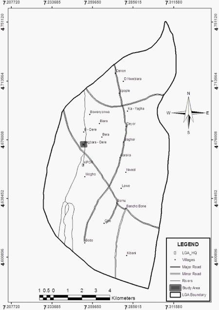
| The sampling was carried out at Kegbara Dere (K-Dere) in Gokana Local Government Area of Rivers State, Nigeria. It is situated in the Niger Delta Area of Nigeria. North of K-Dere is bounded by B-Dere and Biara communitiesin the north; Kpor and Bomu in the south; in the east by Bera community while it is bounded in the west by Onne in Eleme Local Government Area. It is situated between longitudes 7.01° and 7.07° E; and latitudes 4.08 and 4.2°N (Figure 1). |
| The area experienced two distinct seasons; the rainy season and dry season. The area is characterized by high temperature, high rainfall (2000-2500mm/yr), and high relative humidity. The area is also characterized by poorly drained soil, low in nutrient due to the leaching of the nutrient down the soil profile as a result of high rainfall. |
| The area is the home of crude oil exploration in Nigeria with a lot of oil resources. The major oil exploration company in the area is Shell Petroleum Development Company (SPDC). As a result, the area experienced a lot of oil spillages leading to high contamination of the environment with crude oil. |
| Three locations within the area (oil exploration area) were selected for the study. The three locations were: crude oil polluted (unremediated) site (A) remediation site (B) and a control site (C). The polluted (unremediated) site (A) was a neglected oil spillage site for 20 years ago; the remediated site (B) was part of the oil spillage site that was remediated by the oil company (SPDC) in 2008. The control was the area without pollution and remediation. |
| Soil auger was used to collect soil samples from these three sites randomly at three different depths of 0-5cm, 10-15cm and 20-25cm. Five (5) sampling points were used for each site (A, B and C) and soil samples collected at the three depths. Soil samples from each site at a particular depth were collected and put into polythene bags and labeled with a masking tape, and then taken to the laboratory for analysis. |
| At the laboratory, soil samples from a particular site and depth were mixed together to form a composite sample. The soil was air dried and all clods and clumps were removed. Soils were sieved through a 2mm sieve to remove coarse particles before analysis. |
| The following parameters were analysis for the soil samples pH, conductivity, total exchangeable cations, phosphate, total organic carbon (TOC), total Hydrocarbon content (THC) and Nitrate content. Soil pH was obtained with a pH meter (Hanna Hi 8314) stabilized for 15 minutes and calibrated between pH 4 and 7 with standard buffer solution; while conductivity was measured with conductivity meter (HACH Ecttesr microprocessor series) respectively. Total hydrocarbon content was measured by spectrophotometric method; total organic carbon content by oxidation method; nitrate content by Kjeldahl method and Phosphate content was measured by ascorbic acid method according to the method of Stewart et al. [19]. The sample was digested for 15minutes on an electro-thermal heater. The digest was filtered and the filtrate was analyzed for total exchangeable cations (Na+, K+, Mg2+ and Ca2+) by Atomic Absorption Spectrophometer method (AAS). Data collected were analysed. |
| Results and Discussion |
| It is a well known fact that crude oil on contaminating soil affects the physical, chemical and biological characteristics of the soil [8,20]. Remediation of oil contaminating soil can improve the soil status through the improvement of the nutrient status as well as the organic matter content. It can also reduce the phytotoxicity of the soil. |
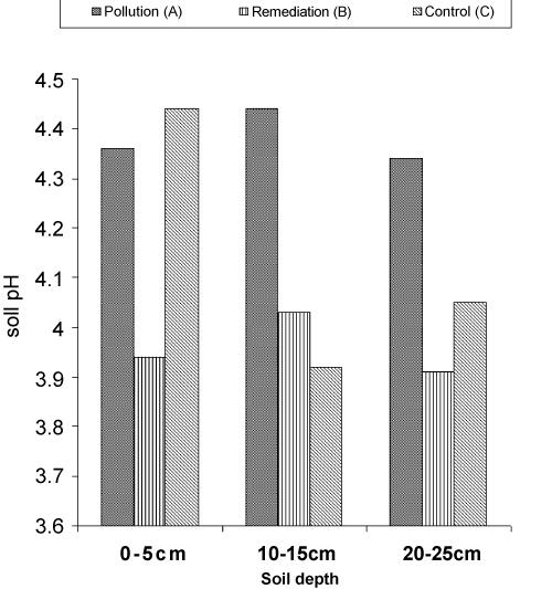
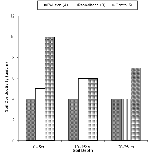
| There was no significant difference between and within sites and soil depths in soil pH. The soil pH of the entire area (polluted, remediated and control) sites were within the same range. The soil at all the sites and depth were generally acidic (below 4.5) (Figure 2). This result is in line with Abii and Nwosu [21]. and Albert who reported similar results on pH of crude oil polluted soils of Niger Delta. Plant grows in soil of pH between the ranges of 3 to 9. Extremes become stressful. The non significance difference between the soil pH in the three sites showed that the remediation of the polluted soil did not have any significant effect on soil pH [22]. Result showed differences in the soil conductivity in the three sites and soil depths. The control site had higher soil conductivity than both the polluted and remediated sites (Figure 3). Within each site, no significant differences occurred in the soil conductivity between the different soil depths. The improvement in the soil conductivity in the remediated site when compared with the unremediated (polluted) site showed the effectiveness of the remediation process to improve the soil conductivity of the area. Also the low soil conductivity in the unremediated site is an indication that crude oil is capable of lowering soil conductivity. |
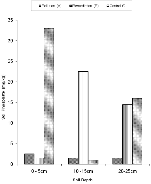
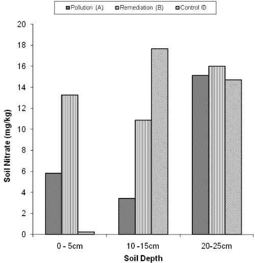
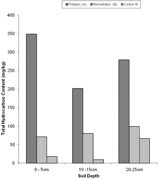
| Result showed differences in the soil phosphate between sites (Figure 4). Remediation site has average higher soil phosphate content than the other two sites (unremediated and control). There was a decrease in the soil phosphate from the 0-5cm soil level down the soil profile in both the polluted (unremediated) and control sites. The highest soil phosphate content in the study was recorded in the control site at depth 0-5cm of value 33mg/kg, while the least value was recorded at the same site (control) at 10-15cm (1mg/kg). The area was generally observed to be low in soil nitrate content (Figure 5). Although between sites, remediated site has the highest soil nitrate content than both the control and polluted (unremediated) sites. Figure 6 showed a general decrease in Total hydrocarbon content of the soil at both the control and remediated sites while the polluted (unremediated) site has the highest Total hydrocarbon content (THC) at all depths of the soil. |
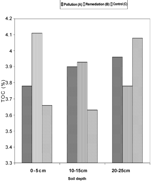
| There was a general fluctuation in the Total Organic Carbon between and within the three sites (Figure 7). The soil TOC in all the study sites ranges from 3.63% to 4.11%, observed at the control site (10- 15cm) and remediated site (0-5cm) respectively. |
| Since there were no much appreciable differences in the soil nutrient (nitrate and phosphate) status of both the remediated site and the unremediated (polluted) site indicate that the remediation process was effective. The low nutrient content in the soil might be attributed to microbial degradation which made use of available nutrient for their metabolic activities. It may also result from leaching of the nutrient down the soil profile by heavy rain that is a common characteristic of the area. Nitrogen and phosphorus have been identified as always limiting factors in a crude oil polluted soil [8]. The reduced THC value in the remediation site might be attributed to microbial degradation as a result of the remediation process, in which case the microorganisms utilized the hydrocarbon as their energy source for their metabolic activities. The high THC in the unremediated (polluted) site might be as a result of the toxicity of the oil to oil degrading microorganisms making biodegradation to be reduced or halted [23]. The high THC content resulting from the crude oil might be the reason for high total organic carbon in the different sites [24]. |
| Total exchangeable cations are presented in table 1. Na+ of the soil in the three sites with higher content in the control site than the other two sites. The K+ content was lower than the Na+ content of the soil at the 3 sites. Between and within the three sites, there were no appreciable differences in the K+ content of the soil but was significantly higher in the control site with the highest value at 10-15cm soil depth (control site) of 2.5meq/kg. Ca2+ was absent in sites especially at the remediated sites while Mg2+ with high abundance in the control site and low in both the remediated and polluted sites except at 20-25cm soil level in the remediation site. The little or zero value of Ca2+ in both the unremediated and remediated sites is an indication that crude oil significantly has drastic negative effect on this ion which even after remediation was not replaced. The high total exchangeable cations in the control site than the other 2 sites (remediation and unremediated) might be attributed to the high conductivity of the soil of that site leading to the release of free ions. |
| Conclusion |
| In conclusion, result from the study showed no appreciable differences between the control and the remediated sites in many of the parameters studied. This is an indication that the remediation carried out was successful. It is therefore, recommended that other sites which were polluted and yet to be remediated be considered for remediation as soon as possible instead of allowing it to stay for many years in order to reclaim more land for agricultural food production as the people depend on farming for their livelihood. Also proper Post-assessment of remediated sites should be done to ascertain the level of remediation in such site. |
| References |
|
Tables and Figures at a glance
| Table 1 |
Figures at a glance
 |
 |
 |
 |
| Figure 1 | Figure 2 | Figure 3 | Figure 4 |
 |
 |
 |
| Figure 5 | Figure 6 | Figure 7 |
Relevant Topics
- Anaerobic Biodegradation
- Biodegradable Balloons
- Biodegradable Confetti
- Biodegradable Diapers
- Biodegradable Plastics
- Biodegradable Sunscreen
- Biodegradation
- Bioremediation Bacteria
- Bioremediation Oil Spills
- Bioremediation Plants
- Bioremediation Products
- Ex Situ Bioremediation
- Heavy Metal Bioremediation
- In Situ Bioremediation
- Mycoremediation
- Non Biodegradable
- Phytoremediation
- Sewage Water Treatment
- Soil Bioremediation
- Types of Upwelling
- Waste Degredation
- Xenobiotics
Recommended Journals
Article Tools
Article Usage
- Total views: 18830
- [From(publication date):
August-2011 - Nov 26, 2025] - Breakdown by view type
- HTML page views : 13549
- PDF downloads : 5281
