Research Article Open Access
Coastal Vulnerability and Shoreline Changes for Southern Tip of India-Remote Sensing and GIS Approach
| V. Joevivek1,2, S. Saravanan1* and N. Chandrasekar1 | |
| 1Centre for GeoTechnology, Manonmaniam Sundaranar University, Tirunelveli 627102, India | |
| 2Civil engineering department, Christ the king engineering college, Karamadai, Coimbatore 641104, India | |
| Corresponding Author : | Saravanan S Centre for GeoTechnology Manonmaniam Sundaranar University Tirunelveli 627 102, India E-mail: geosaravanan2000@yahoo.co.in |
| Received May 20, 2013; Accepted July 10, 2013; Published July 15, 2013 | |
| Citation: Joevivek V, Saravanan S, Chandrasekar N (2013) Coastal Vulnerability and Shoreline Changes for Southern Tip of India-Remote Sensing and GIS Approach. J Earth Sci Clim Change 4:144. doi: 10.4172/2157-7617.1000144 | |
| Copyright: © 2013 Joevivek V, et al. This is an open-access article distributed under the terms of the Creative Commons Attribution License, which permits unrestricted use, distribution, and reproduction in any medium, provided the original author and source are credited. | |
Visit for more related articles at Journal of Earth Science & Climatic Change
Abstract
The present research aims to classify the vulnerable risk zones of the Southern tip of India using shoreline change analysis and coastal vulnerability index (CVI). The shoreline change analysis has been done by automatic image analysis techniques using multi-temporal Landsat data (1973, 1992, 2000 and 2006). The results have shown remarkable erosion was found in Cape Camoron (Left) (4.21 m/year), Idindakarai (4.56 m/year) and Vijayapathi (4.66 m/year). In contrast, the station between Chinna muttam and Visvanarayanapuram has predominant deposition. The CVI index were established based on following six variables: Geomorphology, Shoreline change rate (m/yr), Coastal slope (deg), Relative Sea level change (mm/yr), Mean wave height (m), Mean Tide range (m). According to the CVI value, Cape Camoron (Left), Idindakarai and Vijayapathi sites are identified as highly vulnerable zones. Overall the study, remarkable coastal landform dynamics observed in chinna muttam. The vulnerable map prepared for the southern tip of Indian coast can be useful to prevent the coastline erosion and future disaster mitigation.
| Keywords |
| Coastal morphology; Risk assessment; Remote sensing; Coastal Vulnerability Index; Shoreline changes; Geographic Information System; Southern tip of India |
| Introduction |
| The dynamics of coastal landforms is mainly controlled by nearshore processes, beach morphology and anthropogenic activities. The unusual natural disasters and continuous engineering activities near a coastal region are effective in inducing rapid changes on coastal landforms resulting coastal hazards. Development activities, global warming, climate change and sea-level rise not only introduce any new types of coastal hazards, but they also stimulate the existing hazards. The southern coastal Tamil Nadu of India faces severe such threats due to rapid changes in geology and geomorphology, sea-level change, tropical cyclones and associated storm surges. |
| The ratio of people living in coastal zones compared with available coastal lands further indicates that there is a greater tendency for people to live in coastal areas than inland. According to the United Nations Environment Programme (UNEP) report, the average population density in the coastal zone was 77 people/km2 in 1990 and 87 people/ km2 in 2000, and a projected 99 people/km2 in 2010 [1]. Collectively, this is placing both growing demands on coastal resources as well as increasing people’s exposure to coastal hazards. At least, 200 million people were estimated to live in the coastal floodplains in 1990 (in the area inundated by a 1 in 1000 year flood), and it is likely that their number will increase to 600 million by the year 2100 [2]. Furthermore, global climate change and the threat of an accelerated sea-level rise exacerbate the already existing high risks of storm surges, severe waves, and tsunamis. Over the last 100 years, global sea level rose by 1.0-2.5 mm/y. Present estimates of the future sea-level rise induced by a climate-change range from20 to 86 cm for the year 2100, with a best estimate of 49 cm. It has been estimated that a 1-m rise in sea-level could displace nearly 7 million people from their homes in India [3]. Hegde and Reju [4] have used coastal vulnerability index to evaluate the hazardous zones at mangalore coast, India. |
| Scientific study of the natural hazards and coastal processes of the Indian coast has assumed greater significance after the December 2004 tsunami because the country learned lessons on the impact of natural hazards in terms of high damage potential for life, property, and the environment. The nation’s rapidly growing population of coastal residents and their demand for reliable information regarding the vulnerability of coastal regions have created a need for classifying coastal lands and evaluating the hazard vulnerability. |
| The present study, therefore, is an attempt to develop a coastal vulnerability index (CVI) for the Southern tip of India using six relative risk variables. In this present work, shoreline changes and vulnerability level along the southern coastal Tamil Nadu have been assessed using remote sensing and GIS. The erosion and accretion made in different parts of the study area have been measured and analysed. The coastal vulnerability index (CVI) has been used to map the relative vulnerability of the study area and also characterize the vulnerability of the coast due to coastal processes and human activities such as understand the mining effect on coastal areas. Coastal sand mining is also actively pursued along the coast (Figures 1a and 1b). Human activities, particularly those that impound sand, can cause beaches to change. These include sand being obstructed from reaching the coast by damming rivers, as well as coastal engineering structures (for example, groins and jetties) that can trap sand moving along the coastline, depriving other areas from receiving sand. Anthropogenic activities like construction of building, sand dune destroyed for Tourism development and sand mining activities (Figures 2-4). Dense populations near by the coast (Figures 5a-5c), are also responsible for erosion, reduction in width of beaches. |
| Study Area and Geomorphology |
| The study area lies between Manavai and Vijayapathi, southern tip of India (Figure 6). The backshore of the beach is limited by urban infrastructures. The Mean Sea Level (MSL) is 2m above the 0m depth chart datum (CD). The local mean tidal range is 0.5m and the maximum tidal level above CD is 1.60 m. The study area has minor river systems such as Palaiyar, Namiyar, Hanuman Nadhi and seasonal streams namely, Nilapparai channel and Puttanar channel. Figure 6 has shown the coastal geomorphology along the study area. Kanyakumari coast (Cape comorin) has major cliffs which are projected towards the sea forming a promontory. Pambar estuary adjoined with sea in the western part of study area, which is one of the minor estuary and manakudi estuary is a major estuary in the district. This is formed by the irrigation canal excess water during monsoon, and the water drained from the irrigational fields mixing with sea. A small creek adjoined in the east coast of the study area locally called as Vaikkal. AVM (Ananda Victoria Maharani) canal runs parallel to the entire coast and mixed with Pambar estuary in the west end of study area. AVM canal runs 100 m from the shoreline in Kotilpad in a width of 5 m. But in the west part of study area, AVM canal 300 m away and running very thin at a width of 1 m wide. The net longshore transport is directed to the north-east along Kanyakumari coast [5]. |
| Materials and Methods |
| Coastal vulnerability index is computed based on the six vulnerable parameters namely shoreline change rate, coastal slope, relative sea level change, mean wave height and mean tide range [6]. According to that, vulnerable parameters and its risky level is presented in Table 1. The process is mathematically described as below, |
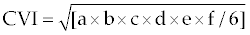 (1) (1) |
| Where, a=Geomorphology, b=Shoreline change rate (m/yr), c=Coastal slope (deg), d=Relative Sea level change (mm/yr), e=Mean wave height (m), f=Mean Tide range (m). Based on the table, calculated CVI values are divided into five classes to highlight different vulnerabilities. The CVI value <4 implies very low risk level, 4 to 6 implies low risk level, 6 to 8 implies moderate risk level, 8 to 10 implies high risk level and >10 implies very high risk level. |
| For instance, Manavai beach has medium cliff geomorphology. So it comes under rank 2. The beach has experienced average shoreline change rate is -2.6363 m/year. So the variable comes under rank 4. Similarly, other four variables attain the rank level 5, 1, 2 and 4 respectively. The vulnerable index is estimated by multiplication of these ranks values divided by six. The result we obtained is 7.3029 (moderate category) (Table 4). |
| The parameters such as coastal slope, relative sea level change, mean wave height and mean tide range are estimated by Toposheet and naval chart datum. The parameter shoreline change rate is derived by remote sensing techniques. |
| The Landsat mission provides long period of earth surface data for the purpose of scientific and commercial developments. The present research we used Landsat-1 MSS, Landsat TM5 and Landsat ETM+ to evaluate the annual shoreline change rate along the present study area. The details raw Landsat data, their sensor type, date of acquisition and specifications are listed in Table 2. In general, raw data need to be calibrated to obtain a closer result of the surface reflectance. Thus we followed Gyanesh et al. for radiometric calibration and atmospheric correction of Landsat data. |
| Direct shoreline digitization provides complicated results due to the presence of water saturated zones in the vicinity of land - water boundary. Therefore, images are classified into two classes namely, land and water bodies using support vector machine (SVM) classifier in ENVI 4.3 software package. The result showing 92% accuracy, however, shoreline near sea - land intercept makes complexity due to wave foams create high intensity value in the Landsat data. To rectify this, Normalized Difference Water Index (NDWI) is used identify real water bodies based on Bo-Cai Gao [7]. Classified raster images are imported into ArcGIS software and geo-rectified by ground control points. Survey of India topographic sheet 1967 (1:50000 scale) is a base map imported into ArcGIS 9.0 and digitized using 60 ground control points which is obtained through handheld GPS. The rectified images are projected in UTM zone 43 of northern hemisphere with WGS 84 datum [8-10]. |
| Further, edges in the classified images are extracted using Sobal filters (Rafael C. Gonzalez and Richard E. Woods, 1999). The extracted shorelines of Landsat images are projected in Arcmap. To calibrate shoreline change rate, toposheet 1967 is fixed as base shoreline. Based on the baseline, transact lines drawn for 21 sites using shape measurement tool. Shoreline change and its corresponding duration is used to estimate shoreline change rate along the study area [12-17]. |
| Results |
| Shoreline changes |
| Shoreline changes are presented with erosion rate, because it is an important valuable parameter for coastal vulnerable detection along the southern tip of India. Table 3 summarizes rates of shoreline changes for 21 sites in the entire stretch, including both erosion and accretion values. In Table 3, positive sign implies accretion and negative sign implies erosion. Shoreline changes from 1973 to 2006, it is noted that, South and East zones are highly changed due to sediment transport, erosion, accretion and also impact of Tsunami (Figure 7a-7d). As a result of the analysis, the most erosion changes were observed at the Cape Camoron, Idindakarai and Vijayapathi stations. In this area the net rate of erosion was found -4.6157 m/yr and no accretion trend observed for studied period in this area. Even though cape Camoron is a rocky cliff nature, it attains moderate erosion due to anthropogenic activities such as coastal construction, irrigation and tourism (Figures 1-3). In contrast, china muttam have achieved rate of accretion +3.8248 m/yr and there was no erosion detected for studied period in this area. Due to the influence of longshore sediment transport coastline movement have been likely from South to South-East. Figures 9a and 9b has shown that direction for erosion is North- Northeast and depositional direction in Northeast-East along the coast. It is an interesting nature that Kudankulam site have experienced erosion to accretion trend during the studied period. This is because, the site have two big groins that have been built in the period of 2000-2003. Unfortunately, it gives the eroding nature (down-drift) to the adjacent locations namely, Idindakarai and Vijayapathi (Figure 9) [15,16]. The remaining stations through the entire stretch have attained average rate of erosion as well as accretion. The most remarkable erosion change was found in Idindakarai. In the period of 1973 -1992, the site has experienced maximum coastline withdrawal of about 1.2 Km. The entire coast has attained maximum erosion at pre-monsoon and maximum deposition on monsoonal seasons [18-21]. |
| Coastal vulnerability |
| With the reference of Table 3, coastal vulnerability zones were classified and mapped using ArcMap 9.0 software package. The coastal vulnerability map is shown in Figure 8. Coastal vulnerability category are classified based on the variables is shown in the Table 4. The results indicate that Koodankulam and Idindakarai stations were highly vulnerable zones. In contrast, Cape camoron and China muttam were low vulnerable zones. In other hands, a trade-off exists between Cape camoron and China muttam with respect to erosion and accretion processes. This is because of channel of sediment transport and littoral drift from south to eastern direction [23,24]. |
| Discussion |
| The coastal vulnerability map shows clear picture on hazardous status of southern Tamil Nadu coast. For each of the sites, the union of each of the variables gave the CVI results as indicated in Table 4. About 50% of the computed values of CVI are 5 to 8, indicating a uniform vulnerability of most of the segments of the coast. The grid indicating the maximum vulnerability, i.e., 12.64, 12.24 and 9.23 correspond to the garnet sand mining region near the mouth of the estuary. The high value in CVI is the result of the high erosion rates experienced and the flat coastal slope accompanied by human settlements and sand mining activities. The next vulnerable region is the Lipuram, Kottapuli and Chettikulam, which has an index score of 7 to 8.0, just ahead of the average vulnerability of 4 to 6.5 (average of 8 values of CVIs obtained). This stretch exhibits a flat coastal slope with the densely populated in nearby coast of Kanyakumari coast. The lowest value of CVI of 3.46 and 1.57 covers the coastal stretch between Kanyakumari and Chinna muttom. This region exhibits rocky promontories and is moderately populated. Also the beaches may be considered to be in a state of dynamic equilibrium, exhibiting a cyclic phenomenon of erosion (during monsoon) and accretion (during summer). The presence of coastal structures such as piers and groins tend to alter the natural erosion and accretion processes along a beach. In addition, the presence of offshore features such as fringing and barrier reefs tend to absorb wave energy available for sediment movement. |
| It has been inferred that maximum hazard has occurred in the coast where there is a river mouth or an estuary as in the case of Lipuram, Lakshmipuram and Koodankulam. And minimum hazard has occurred in the coast where rock exposures are present in Southern Tamilnadu coast. |
| It has been inferred also that the impact of the coastal erosion/ storm/tsunami surge was high in the southern most part of the study area as most of the high vulnerable beaches falls on that region like Chinnamuttom, Kanyakumari, Manakudy and Pallam since they are awfully very much exposed to the refracted and diverted waves from Sri Lanka (Figure 10). |
| Conclusion |
| Without doubt, the best result for any CVI computation is heavily dependent on the quality of the data used and different types of data used, which influence the vulnerability of a particular coastal stretch between Manavai to Vijayapathi. With the available data, we find that the South tip of Indian coast is concerned in highly vulnerable category. Most of the segments (8 numbers) have a CVI value of range between 1.0 to 4.0 and they are taken to be moderate vulnerable due to rocky exposure and less population nearby coast. The quality of the present index can be enhanced by the addition of further variables, like wave height, tidal range, probability of storm, etc. |
| The CVI is an indication of the relative vulnerability of the various segments of the southern tip of Indian coast. The map prepared for the Southern tip of Indian coast under this study can be used by state and district administrations involved in the disaster mitigation and management to take advance action to mitigate the effects of impending disasters and to prioritize areas for evacuation. |
| Acknowledgement |
| The authors wish to thank the Department of Science and Technology, Government of India for providing financial support and necessary equipments in the form of project (ES/11/526/2000, dated: 09/12/2004) to perform this study. And also we wish to thank the Dr.Bhoop singh, Director, NRDMS Division, DST, New Delhi for their kind support to carrying out this study. |
References
|
Relevant Topics
- Atmosphere
- Atmospheric Chemistry
- Atmospheric inversions
- Biosphere
- Chemical Oceanography
- Climate Modeling
- Crystallography
- Disaster Science
- Earth Science
- Ecology
- Environmental Degradation
- Gemology
- Geochemistry
- Geochronology
- Geomicrobiology
- Geomorphology
- Geosciences
- Geostatistics
- Glaciology
- Microplastic Pollution
- Mineralogy
- Soil Erosion and Land Degradation
Recommended Journals
Article Tools
Article Usage
- Total views: 17404
- [From(publication date):
August-2013 - Dec 19, 2025] - Breakdown by view type
- HTML page views : 12164
- PDF downloads : 5240