Research Article Open Access
Environmentally- Friendly Proposals for Coastal Stability at Rosetta Promontory, Nile Delta
Ali Masria*, Khaled AbdelazizFaculty of Engineering, Mansoura University, Mansoura, Egypt
- *Corresponding Author:
- Ali Masria
Faculty of Engineering
Mansoura University,
Mansoura, Egypt
Tel: +2 (0)10 26179066
E-mail: ali_masria@yahoo.com
Received date: March 28, 2017; Accepted date: May 04, 2017; Published date: May 10, 2017
Citation: Masria A, Abdelaziz K (2017) Environmentally- Friendly Proposals for Coastal Stability at Rosetta Promontory, Nile Delta. J Marine Sci Res Dev 7:227. doi: 10.4172/2155-9910.1000227
Copyright: © 2017 Masria A, et al. This is an open-access article distributed under the terms of the Creative Commons Attribution License, which permits unrestricted use, distribution, and reproduction in any medium, provided the original author and source are credited.
Visit for more related articles at Journal of Marine Science: Research & Development
Abstract
The Nile Delta Coast is a dynamic system which was in equilibrium or experienced huge amounts of sediment transported with the water discharges from Nile River to the Mediterranean Sea through the Nile branches. A remarkable decrease in the sediment discharges arises with the construction of barrages, low Aswan dam, and Aswan High Dam along the river since the beginning of the 20th century which trapped almost all the flood sediments in its storage basin. Consequently, the Nile Delta coastal zone has suffered from erosion, especially around the three main headlands, Rosetta, El Burullus, and Damietta. Erosion is not the only challenge facing the Delta coast, but also, siltation inside the inlets discharge to the sea. A calibrated depth-averaged model has been used to morphological changes around the nourishment area at Rosetta promontory, and testing the validity of some alternatives proposed to mitigate the outlet problems. Among these alternatives: diversion of side channel from the sea to the Nile River, and finally, the sand motor technique. The aim of this paper is to test different proposed alternatives and analyze it in terms of morph-dynamic processes to reach an applicable solution for the instability of the promontory.
Keywords
Coastal stability; Rosetta promontory; Mediterranean Sea
Introduction
The Nile Delta was formed by sedimentary processes occurred between the Upper Miocene period and the present [1]. The advance and recession of the shoreline are governed by the amount of river sediment discharged into the Mediterranean to those sediments that are lost by the dynamic factors of the wind, wave and current action [2].
The study area mainly has two activities; fishing, and agriculture. The agriculture sector includes cultivating date palms, and fruit tree [3].
Fisheries activities represents an important source for income. Rosetta outlet is the only navigation path for the fishermen from the Nile river branch to the Miditeranean sea.Although the fishing sector is vital to population,the city has no fishing port. No location for the fisheries association which is comprised of about 12000 members (40% of Rosetta population are fishermen) [4].
There are numerous fish cages at Rosetta branch allocated in ad hoc manner without any monitoring leads to different problems at the navigation path. Rosetta city still has low economical importance compared to other coastal cities such; Alexandria and Port Said. The variables that have been on the basis of measurement are essential values to the development of global and local coastal cities [5]. Although its low score, but more attention is given to Rosetta city to increase tourism.
The Rosetta promontory extended seaward actively by 14 km [1]. Since the beginning of the 20th Century dramatic erosion has occurred along some parts of the Nile Delta Coast [6,7]. This occurs due to the building of many water control structures like; barrages, dams on the main course of the Nile river. During the last decades, great attention has been paid to the most vulnerable coastal zones represented in promontories: Rosetta as shown in Figure 1, and Damietta. Rosetta promontory experiences a severe erosion threatens seawall which protects the retreat of the coastline [8]. The another challenge is the accumulation of the sediments inside the inlet that hinders the navigation and affects ecological system [9].

Figure 1: Location Map for Rosetta promontory from (Kaiser, Aziz, & Ghieth, 2014).
There is a considerable interest over the last decades in the marked coastal changes observed along Rosetta promontory, leading to studies of coastal geomorphology, analysis of beach profiles up to the 6 m depth, aerial photography analysis, satellite image analysis; shoreline changes, dynamic factors, and sediment transport.
Many types of research were performed to solve the siltation problem. Mahmoud et al. [10] used one-dimensional model (SOBEK) to address the closure of the outlet from the perspective of efficiency of cross sections to convey and release the emergency discharges to the sea. Delft 3D software was used by [11] to study how to minimize the sedimentation problem inside the Rosetta estuary by proposing two jetties Although continuous dredging works were implemented to mitigate siltation inside the inlet, the problem still occurs [12].
On the other hand, the erosion problem also was investigated through many attempts to overcome the migrated erosion downdrift of the eastern and western seawalls. Shoreline erosion at the southwestern coastline of the Rosetta promontory was investigated numerically by [9] to produce a stable condition to the existing seawall located west of Rosetta promontory by proposing two alternatives (detached breakwater and series of groins). It was concluded that the detached breakwaters result in severe local scour in front of the western seawall, while the groins produce sedimentation that expected to stabilize the existing seawall. In addition, [13] concentrated on the eastern side of the Rosetta promontory because, after finishing the construction of the eastern revetment, severe erosion took place east of the revetment. They checked groins system for protecting this important stretch of the promontory from severe erosion. To mitigate severe erosion in front of seawalls, different alternatives of soft and hard measures were investigated by a) [14,15].
Although, the process of building defenses against the sea has not yet exhausted the technological means available around the world, the “hard engineering” approach is strongly being challenged [16]. Due to lack of sustainability of the “hard engineering” approach, innovative concepts that build with nature provide a guideline for coastal protection strategies that lead to sustainability, following gradual changes in climate and other environmental conditions, while maintaining flood safety, ecological values and socioeconomic functions.
For this study, the innovative Dutch beach replenishment strategy is known as “mega-nourishment,” was reviewed . It is based on putting very large amounts of sand every 20 years, rather than smaller amounts every 1-5 years [17,18]. Waves and wind re-distribute the sand along the shore, with fewer bulldozers and pressurized slurry pipes. It also, offers habitat benefits, creating undisturbed large sandy beaches continuing for decades. On the other hand, it provides an aesthetic and recreational beach than the typical tourist one [19].
The aim of this paper is to test other alternatives that build with nature and have a minimum ecological effect. These scenarios include testing1) sand engine technique that has recently been implemented in the Netherlands aiming to provide safety against flooding [20], and 2) constructing a new channel from the sea to the Rosetta branch to provide the estuary with water discharges required for flush the accumulated sediments at the outlet of the River.
Numerical Simulation Using Coastal Modeling System (Cms)
Model description
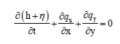
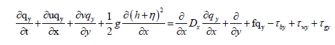
Depth-integrated continuity and momentum equations: The CMSFlow solves depth-integrated continuity and momentum equations using a finite-volume method [21]. The CMS-Flow 2D model equations are based on the shallow water equations. The 2D depth-integrated continuity and momentum equations solved by the CMS-flow are:
 (1)
(1)
 (2)
(2)
 (3)
(3)
Where the subscripts x and y indicate the x and y components and: h = still-water depth, g=acceleration due to gravity, η=water-surface elevation, f=Coriolis parameter, t=time, q=flow per unit width, u=depth-averaged velocity in x-direction, D=diffusion coefficient, v=depth-averaged velocity in y-direction, τw=surface stress, τb=bottom stress and τS=wave stress.
Wave-action balance equation
The CMS-Wave is a spectral wave transformation model [22]. It solves the steady-state wave-action balance equation on a non-uniform Cartesian grid.
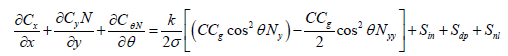 (4)
(4)
Where N=E / σ is the frequency and direction dependent waveaction density, defined as the wave energy- density E=E (x, y, σ, θ) divided by the intrinsic frequency σ; Ny and Nyy denote the first and second derivatives with respect to y, x and y are the horizontal coordinates; θ is the wave direction measured counterclockwise from the x-axis; C and Cg are wave celerity and group velocity; Cx, Cy, and Cθ are the characteristic velocity with respect to x, y and θ respectively; k is an empirical parameter representing the intensity of the wave diffraction effect.
The right-hand side terms respectively, are: Sin is the source (e.g., wind input), Sdp is the sink (e.g., bottom friction, wave breaking, and white capping), Snl is the nonlinear wave-wave interaction.
Sediment transport equation
There are three sediment transport models available in the CMS: (1) Equilibrium total load, (2) Equilibrium bed load plus advectiondiffusion for suspended load, and (3) Non-equilibrium total load.
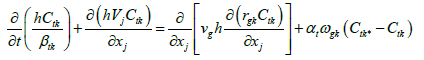
In this study, the non-equilibrium sediment transport model was used. In this model, the sediment transport is separated into current and wave-related transports. The transport due to currents includes the stirring effect of waves, and the wave-related transport includes the transport due to asymmetric oscillatory wave motion as well as steady contributions by Stokes drift, surface roller, and undertow. The currentrelated bed and suspended transports are combined into a single totalload transport equation, thus reducing the computational costs and simplifying the bed change computation. The 2DH transport equation for the current-related total load [23].
 (5)
(5)
Where j=1, 2, k=1, 2,.........., n; n is the number of sediment size classes and t = time [s]
1. h=water depth [m], xj=Cartesian coordinate in the j direction [m], vj=total flux velocity [m/s]; Ctk=actual depth-averaged total-load sediment concentration for size class k defined as Ctk=qtk/ (Uh) in which qtk is the total-load mass transport [kg/m3]; Ctk*=equilibrium depthaveraged total-load sediment concentration for size class k[kg/m3]; βtk=the total-load correction factor; rsk=fraction of suspended load in total load for size class k; νs=horizontal sediment mixing coefficient [m2/s]; αt=total load adaptation coefficient; ωsk=sediment fall velocity [m/s]. The near-bed sediment concentration or concentration capacity is calculated with one of the following transport formulas: Lund-CIRP, Van Rijn, Watanabe, and Soulsby-van Rijn.
a. Model schematization
Coastal Modeling System (CMS): CMS is a process-based suite of models integrate hydrodynamics, sediment transport, and morphological changes in the coupling of two modules, CMS-Flow and CMS-Wave. It is qualified to simulate waves, interacting waves and currents, water level, sediment transport, and morphology change at coastal inlets, entrances and nearby. The CMS was developed specifically for modeling coastal inlet processes and morphological changes. CMSFlow solves depth-integrated continuity and momentum equations using a finite-volume method [23]. CMS-Flow passes the water level and current velocity to CMS-Wave. CMS-Wave is a spectral wave transformation model that solves the steady-state wave-action balance equation on a non-uniform Cartesian Grid. The wave model calculates wave refraction, shoaling, reflection, diffraction, and breaking. The radiation stress induced by breaking is computed and passed to CMSFlow for the calculation of wave-induced longshore current, which are necessary for calculating sediment transport due to the combined effect of waves and currents. Three sediment transport models are available in CMS; a sediment mass balance model, an equilibrium advectiondiffusion model, and a non-equilibrium advection-diffusion model. Non-equilibrium transport model is used in this study.
Grid and boundaries: An accurate bathymetric grid is essential because wave propagation is strongly influenced by near-shore bathymetry, so a high spatial resolution is necessary to accurately resolve the inlet. The study area was surveyed between 2005 and 2006. Two CMS model grids were developed for representing Rosetta promontory, one for CMS-Wave, and the other for CMS-Flow and sand transport. The inline version of CMS-Flow was applied in this study which contains CMS-Flow and CMS-Wave within a single code for model efficiency. The lateral extent of both CMS grids was extended 7 km offshore beyond the depth of closure which no considerable sediment movement. Additionally, the lateral extent (18 km) of the model domain was defined to include several focus areas of shoreline. The cross-shore length of the CMS-Flow grid was set to the same location as the CMS-Wave grid, which was set to the offshore location of the contour depth of the forcing (or wave data) (Figures 2 and 3).

Figure 2: Model grids with boundary condition for Rosetta Promontory, resolution increases at the vicinity of the throat and the surf zone, (a) CMS-Flow grid, and (b) CMS-Wave grid after (Masria et al., 2014b).

Figure 3: Model grids with boundary condition for Rosetta Promontory, resolution increases at the vicinity of the throat and the surf zone, (a) CMS-Flow grid, and (b) CMS-Wave grid after (Masria et al., 2014b).
Refining the inlet and nearshore zone enabled the capturing of the sediment transport and the morphological change processes where they mainly occur. Hence, a variable sized rectangular-cell grid system, with a spatial resolution ranging from 20*20 m in the vicinity of the inlet, and the nearshore zone, navigation channel to 70*120 m near the sea boundary was generated with a number of sea cells=24613. Each CMS grid was forced along the ocean boundary (Figure 4). CMS-Wave propagates spectral waves from the offshore ocean boundary toward land. The forcing in the CMS-Flow grid for this project was a watersurface elevation for the period from October 2005 to May 2006, in addition, flow discharges from the outlet were included. In order to transform the wave data from the offshore station at depth of 18 m to the model boundary at 11m depth, the maximum entropy code established by CMS developers to transform the wave data to the model boundary.

Figure 4: The model domain of Rosetta estuary.
Bathymetric data: The bathymetric survey including 50 profiles that have been utilized in the simulation was conducted in October 2005 during the formation of the spit inside the inlet. The bathymetric survey of May 2006 was used to calibrate the numerical model. Figure 3 shows the bathymetric map of the promontory.
Wave, tide and sediment grain size data: The wave data are time series data (every six hours) which are the averaged wave climate of five years of actual measurements between 1986 and 1990. It is clear that the prevailing wave direction comes from NW [12,13]. Figure 4 shows the average wave height-direction distribution. The wave data were recorded at depth (18 m). A maximum entropy code was applied for the directional spectrum to transform the wave from depth 18 m to the model boundary at 11 m depth. The extracted wave data at 11m will be the input for the model.
Nile Delta coast is known as a micro-tidal, semi-diurnal tidal regime (tidal range 20-30 cm). The available tide data which are represented by water levels at Rosetta promontory covered the period from October 2005 to October 2006 as a time series (every half hour). Figure 5 shows a sample of the measured water levels.

Figure 5: Average wave direction-height distribution at Rosetta area (O. Frihy & Dewidar, 2003).
The sediment grain sizes (d50) at the nearshore zone a re between 0.16 mm and 0.24 mm according to previous researchers [9,24].
b. Model calibration and validation
The setup of the CMS model (flow, and wave), forcing data, sensitivity analysis, calibration and validation of the model were described in details by Masria et al. [25].
The tested protection scenarios
To mitigate the instability of the coastal zone at Rosetta promontory represented in shoreline erosion, and accretion inside the inlet, three different alternatives have been investigated using : 1) diversion channel from the sea to the Nile River, and 2) the sand motor technique (Figure 6).

Figure 6: A sample of measured water levels data ( at Abu-Quir station) by Coastal Research Institute, Egypt 2005, after (Masria, Negm, Iskander, & Saavedra, 2014c).
a. Diversion channel from sea to river: This scenario assumes a new channel path to divert flow discharges from sea to river in order to compensate Nile river flow discharges at the last reach of Rosetta branch as water and sediment discharges of the Nile River have been decreased since constructing the water control structures, mainly AHD along the River Nile in 1964. This proposal is supposed to enhance the circulation process from the river to the sea which required to mitigate siltation problem at the outlet. Two scenarios in this proposal have been investigated as shown in Figure 7. The first scenario is to divert the sea water to the river through a right channel (100 m width), and the other one through a left channel with the same width. The depth of both channels was also changed as 3 m, and 5 m respectively.

Figure 7: The two diverted channels: a) Right channel, and b) Left channel.
b. Sand motor technique: Sand engine is a new innovative soft engineering intervention, that has recently been implemented in the Netherlands aiming to provide safety against flooding , and shoreline erosion as a result of the expected sea level rise and storms [20,26-28]. Such an approach could provide useful elements for other low-lying areas as it creates natural dune, and sustain coastal development.
The Sand Engine nourishment has been investigated numerically in Netherland to test the performance of local mega-nourishments as a countermeasure for the expected coastal recession in the 21st century [29]. According to the initial observations, a redistribution of the sand feeding the adjacent coasts occurred, The proposed concept, a single mega-nourishment, is expected to be more economical, efficient and environmentally friendly in the long term than traditional nourishments (nearshore, and shoreface) Figure 8a [30-32].

Figure 8: a) Aerial photograph of the Sand Engine after completion (September 2011) looking southward, after, (Stive et al., 2013a), b) Snapshot of the sand engine at Rosetta promontory.
In our study area, a sand engine technique was tested using CMS software package. It includes placing the nourishment material to a depth equal to 6 m (distributed equally at each cell) in the eastern part of the promontory (the most vulnerable area of erosion in front of seawall) as shown in Figure 8b. The total volume of the sand engine is about 3.5M m3.
Results And Discussion
Diversion channel from sea to river
Two observed points have been assigned inside, and outside the outlet, as shown in Figure 7 to extract the water elevation and current magnitude. Figure 9 shows the results of water elevation and current magnitude at the two observed points (for no action case, and in the existence of the diverted channel from the sea to the river) corresponding to different conditions of wave and tide. It is clear from these figures, that the difference between water elevations at both points can be neglected, whereas the distinction in current magnitude is noticeable. To deeply investigate the validity of this proposal, a simulation over one year was performed to check the morphological change and wave heights at each point.

Figure 9: The water elevations, and the current magnitude at the different two points.
Morphological changes (channel on the right side)
The first one is no action case, the second is to propose a diverted channel (100 m width) from the sea to the river Figures 10 and 11 show the morphological change and (bed evolution with current magnitude) after one year for the three tested scenarios with 3 m depth, and the last one is the same as the second , the only difference is the channel depth (5 m). It is clear from the figures that erosion and accretion patterns are nearly the same as the no action case. The formation of the spit inside the inlet has not been changed, although the existence of a side channel. This is due to the accumulation of the sediment in front of the channel at the seaside that prevents the water to be discharged from the sea to the river. The accumulation of the sediments is a result of the littoral drift caused by the inclined dominant wave angle (WNW) with the shoreline orientation. Consequently, the wave height inside the diverted channel is almost zero as shown in Figure 12.

Figure 10: Model results of the morphological changes of different scenarios a) no action, b) diverted channel of 3 m depth, and d) diverted channel of 5 m depth. Negative values express erosion, and the positive ones express accretion.

Figure 11: Model results of bed evolution with current velocity for different scenarios a) no action, b) diverted channel of 3 m depth, and c) diverted channel of 5 m depth.

Figure 12: Model results of the wave height distribution of different scenarios a) no action, b) diverted channel of 3 m depth, and c) diverted channel of 5 m depth.
Morphological changes (channel on the left side)
In this section, two scenarios as the same previous section were proposed, the only difference here is that the diverted channel is located at the left side instead of right one.
Figures 13-15 show the model results of morphological changes, depths (with current velocity), and wave height distribution after one year for the two scenarios compared with no action case. Figure 16 shows the current magnitude for the two cases. It is illustrated that tested scenarios enhance the situation locally, particularly in front of the channel from the river side, but with a limited effect on the sedimentation inside the inlet.

Figure 13: Model results of the morphological changes of different scenarios a) no action, b) diverted channel of 3 m depth, and c) diverted channel of 5 m depth. Negative values express erosion, and the positive ones express accretion.

Figure 14: Model results of bed evolution with current velocity for different scenarios a) no action, b) diverted channel of 3 m depth, and c) diverted channel of 5 m depth.

Figure 15: Model results of the wave height distribution of different scenarios a) no action, b) diverted channel of 3 m depth, and c) diverted channel of 5 m depth.

Figure 16: Model results of the current magnitude of the two scenarios a) diverted channel of 3 m depth, and c) diverted channel of 5 m depth.
From the previous figures for the above-mentioned scenarios of the diverted channels, it is clear that there is no clear effect of it. In addition, according to the previous literature, constructing such channel may be dangerous. This is because the reduction is characterized by the important phenomenon of necking and part separation (at the left side). This channel may repeat the same failure scenario of the western part of the promontory that occurred previously [12,13].
The severe erosion rate was due to the phenomenon of necking and part separation. It is formed by the erosion of both sides of the western part of the inlet, i.e. the erosion by long-shore current on the seaside and by the reflected waves on the Nile side that hit the Nile eastern bank. When the width of the western part became narrow enough (Figure 17) it will be flooded and separated from the mainland by the action of high waves during the winter season. As a result of the gradual recession of the western part, the eastern part became exposed to the wave action from the NW sector causing severe erosion of this part.

Figure 17: Shoreline Advance along Rosetta Promontory, (1500-1900), (El Sayed et al., 2007).
• Sand motor technique: The relative influence of waves and tides on the Sand Motor were investigated numerically by means of hydrodynamic simulations and sediment transport calculations.
• Bed evolution: Figure 18 shows the bed evolution of the promontory through a successive Snapshot for the water depths . Although it requires big amounts of the nourishment material, but it creates new beaches not only on the local level (Rosetta), but it may extend to farther distances. As sediment transport will respond to the changes in hydrodynamics caused by the presence of the sand motor, the total sediment transport at the outlet especially in front of the eastern seawall has been decreased as shown in Figure 19.

Figure 18: Successive Snapshot for the water depths due to the sand engine method at Rosetta promontory. a) At the beginning of the run, b) 3.5 months later, and c) after one year.

Figure 19: Model results of the total sediment transport of the (a) sand engine method, and (b) no action scenarios.
It is expected for the sand motor to be a great solution for combating sea-level-rise resulted in coastal recession on open coastal zones [20]. So, in order to deeply evaluate the effect of sand motor techniques, a long-term simulation for five years has been conducted. Figure 20 shows the results of bed evolution and the current velocities over two, and five years compared to the start of the run. The proposed concept of a single mega-nourishment is expected to be more, economical, efficient, and environmentally friendly in the long term than traditional nourishments (beach and shoreface) presently being used to mitigate the coastal recession. Moreover, it rehabilitates a wide range of the coastline around under the effect of coastal processes at the nourished area.

Figure 20: Model results of the water depths and current velocities: a) at the beginning of the run, b) after two years, and, c) after five years.
Conclusion
The coastal inlets are of great economic and environmental significance. Although many hard measures have been constructed to mitigate the shoreline against recession and siltation inside the inlets, it still has negative effects on the environment. So, developing new techniques that are environmentally friendly to save the coastal environment become an urgent need to achieve the coastal zone management. In Egypt, Rosetta outlet suffers the same problems. Different hard, and soft measures were constructed to mitigate these problems, but the situation is still unstable.
Two different alternatives that build with nature and have minimum ecological effect have been proposed. The first scenario is to divert channels from sea to the river to provide water discharges to the river after the lack of water discharges occurred since1964 due to AHD construction in order to retrieve the hydraulic stability for the cross section of Rosetta outlet. The other one is to investigate the effect of sand motor technique. A calibrated 2D morphodynamic model (CMS) was used to conduct the simulation of both scenarios.
The simulation results showed that diverted channel enhances the situation locally, particularly the left channel, but with a limited effect on the sedimentation inside the inlet and this is due to the angle of the prevailing wave that govern the siltation in front of the channels at the seaside. The sand motor techniques expected to be more efficient and economical in the long term rather than traditional shoreface nourishments, and the other hard measures. that are being used to treat coastal erosion The great benefit from this solution is to build with nature, and preserve the ecological situation. So, it is recommended to investigate sand motor technique at a regional scale to precisely study this innovative method.
Acknowledgment
All thanks for my dear Eng. Lihwa Lin, Research Hydraulic Engineer, at Coastal and Hydraulics Laboratory, US Army Corps of Engineers for his great and continuous technical support. It should be mentioned also that this work was partially supported by JSPS “Core-to-Core Program, B.Asia-Africa Science Platforms”.
References
- Fanos AM, Khafagy AA, Dean RG (1995) Protective works on the Nile Delta coast. J of Coastal Res 11: 516-528.
- Elsayed MAK, Younan NA, Fanos AM, Baghdady KH (2005) Accretion and erosion patterns along Rosetta promontory, Nile Delta coast. J of Coastal Res 21: 412-420.
- El Raey M, Nasr S, Frihy O, Fouda Y, El-Hattab M, et al. (2005) Sustainable management of scarce resources in the coastal zone (article). D06.2: Case Study Report (Egypt) Abu Qir Bay, Egypt.
- Egypt R (2006) Team of "Rapid Urban Sector Profiling for Sustainability Studies (RUSPS), Programme, United Nations Human Settlements States, Regional Office for Africa and the Arab.
- AbdeL-Latif T, Ramadan ST, Galal AM (2012) Egyptian coastal regions development through economic diversity for its coastal cities. HBRC Journal 8: 252-262.
- Smith SE, Abdel-Kader A (1988) Coastal erosion along the Egyptian delta. J Coastal Res 4: 245-255.
- Badr AMA, Abdella FA, El-kolfat AI (2005) Coastal changes along Rosetta promontory. Alexandria Engineering Journal 44: 91-100.
- Frihy OE, Shereet SM, El Banna MM (2008) Pattern of beach erosion and scour depth along the Rosetta Promontory and their effect on the existing protection works, Nile Delta, Egypt. J of Coastal Res 857-866.
- Ahmed ASM (2004b) Mathematical Model Investigation Of The Suitable Countermeasure For The Erosion Problem At Rosetta Promontory, Egypt. In: Proceedings of the Sixth International Summer Symposium, JSCE, Saitama University p: 157-160.
- Mahmoud MK, El-Balasy A, El-ghorab EA (2006) Mathematical model of the sedimentation problem at rosetta promontory. In Tenth International Water Technology Conference, IWTC10, Alexandria, Egypt p: 945-955.
- Ahmed ASM (2004a) Mathematical model investigation of the suitable countermeasure for the accretion problem at Rosetta estuary, Egypt. In: OCEANS��?04. MTTS/IEEE TECHNO-OCEAN'04 1: 78-82.
- El Sayed WR., Ali MA, Iskander M, Fanos M (2007) Evolution of Rosetta Promontory during the Last 500 Years , Nile Delta Coast , Egypt. Proceedings of the Eight International Conference on the Mediterranean Coastal Environment, MEDCOAST 07, Alexandria, Egypt p: 1.
- Elsayed MA, Mahmoud SM (2007) Groins system for shoreline stabilization on the east side of the Rosetta Promontory, Nile Delta coast. J of Coastal Res 23: 380-387.
- Masria A, Negm AM, Iskander MM, Saavedra OC (2014a) Hydrodynamic modeling of outlet stability case study Rosetta promontory in Nile delta. Water Science 27: 39-47.
- Negm A, Masria A, Iskander M, Saavedra OC (2015) Towards a Sustainable Stability of Coastal Zone at Rosetta Promontory/Mouth, Egypt. Oceanography 3: 1.
- Kabat P, Fresco LO, StiveMJF, Veerman CP, van Alphen JSLJ, et al. (2009) Dutch coasts in transition. Nature Geoscience 2: 450-452.
- Ruiz-MartÃnez G, Mariño-Tapia I, Baldwin EGM, CasarÃn RS, Ortiz CEE (2015) Identifying Coastal Defence Schemes through Morphodynamic Numerical Simulations along the Northern Coast of Yucatan, Mexico. J of Coastal Res.
- Bird E, Lewis N (2015) Beach Renourishment Principles. In Beach Renourishment Springer p: 41-100.
- Stevens R, Hill K, Burgess N, Grady A (2013) New beach Designs as Urban Adaptation to Sea Level Rise. Council of Educators in Landscape Architecture (CELA) Conference paper. Austin, Texas: CELA.
- Stive MJF, Schipper Ma, Luijendijk AP, Aarninkhof SGJ, van Gelder-Maas C, et al. (2013a) A New Alternative to Saving Our Beaches from Sea-Level Rise: The Sand Engine. J of Coastal Res 290: 1001-1008.
- Lin L, Demirbilek Z, Mase H, Zheng J, Yamada F (2008) CMS-Wave: A nearshore spectral wave processes model for coastal inlets and navigation projects. (No. ERDC/CHL-TR-08-13). Engineer Research and Development CenterVicksburg MS Coastal and Hydraulics Lab (techreport).
- Sanchez A, Wu W (2011) Nonuniform Sediment Transport Modeling at GraysHarbor. WA book, World Scientific Publishing Company: Singapore.
- Reed CW, Brown ME, Sánchez A, Wu W, Buttolph AM (2011) The Coastal Modeling System Flow Model (CMS-Flow): Past and Present. J of Coastal Res p: 1-6.
- Abo Zed A, Shereet S M (2005) Dynamic of Near Shore Sediment and Coastal Changes Astride Rosetta Branch, Egypt. Emirates J for Eng Res 10: 51-61.
- Masria A, Abdelaziz K, Negm A (2015) Testing a combination of hard and soft measures to enhance the stability of rosetta outlet. Oceanography: Open Access, 2016.
- Chan JCW, Chan KP, Yeh AGO (2001) Detecting the nature of change in an urban environment: A comparison of machine learning algorithms. PE and RS J 67: 213-226.
- Wengrove ME, Henriquez M, Schipper MA, Holman R, Stive MJF (2013) Monitoring morphology of the sand engine leeside using Argus��? cBathy. In Coastal Dynamics 2013: 7th International Conference on Coastal Dynamics, Arcachon, France, 24-28 June 2013.
- De Vries S, RadermacherM, De Schipper MA, Stive MJF (2015) Tidal dynamics in the sand motor lagoon. In E-proceedings of the 36th IAHR World Congress, The Hague, the Netherlands, 28 June-3 July 2015.
- Phelps JJC, Brown JM, Plater AJ, Barkwith A, Hurst MD, et al. (2015) Modelling coastal erosion and sediment transport on the Dungeness Foreland, UK. National Oceanography Centre.
Relevant Topics
- Algal Blooms
- Blue Carbon Sequestration
- Brackish Water
- Catfish
- Coral Bleaching
- Coral Reefs
- Deep Sea Fish
- Deep Sea Mining
- Ichthyoplankton
- Mangrove Ecosystem
- Marine Engineering
- Marine Fisheries
- Marine Mammal Research
- Marine Microbiome Analysis
- Marine Pollution
- Marine Reptiles
- Marine Science
- Ocean Currents
- Photoendosymbiosis
- Reef Biology
- Sea Food
- Sea Grass
- Sea Transportation
- Seaweed
Recommended Journals
Article Tools
Article Usage
- Total views: 5482
- [From(publication date):
June-2017 - Aug 29, 2025] - Breakdown by view type
- HTML page views : 4458
- PDF downloads : 1024