 Spanish
  Chinese
  Russian
  German
  French
  Japanese
  Portuguese
  Hindi
Hindi Our Group organises 3000+ Global Conferenceseries Events every year across USA, Europe & Asia with support from 1000 more scientific Societies and Publishes 700+ Open Access Journals which contains over 50000 eminent personalities, reputed scientists as editorial board members.
Open Access Journals gaining more Readers and Citations
700 Journals and 15,000,000 Readers Each Journal is getting 25,000+ Readers
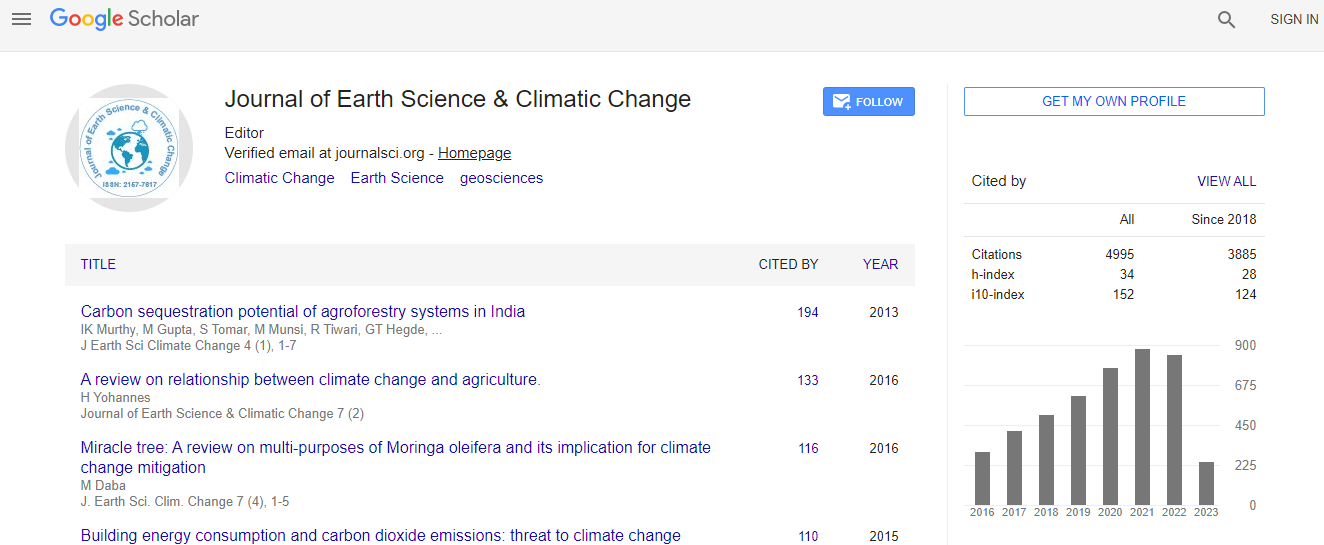
Google Scholar citation report
Citations : 7873
Journal of Earth Science & Climatic Change received 7873 citations as per Google Scholar report
Journal of Earth Science & Climatic Change peer review process verified at publons

Indexed In
- CAS Source Index (CASSI)
- Index Copernicus
- Google Scholar
- Sherpa Romeo
- Online Access to Research in the Environment (OARE)
- Open J Gate
- Genamics JournalSeek
- JournalTOCs
- Ulrich's Periodicals Directory
- Access to Global Online Research in Agriculture (AGORA)
- Centre for Agriculture and Biosciences International (CABI)
- RefSeek
- Hamdard University
- EBSCO A-Z
- OCLC- WorldCat
- Proquest Summons
- SWB online catalog
- Publons
- Euro Pub
- ICMJE
Useful Links
Recommended Journals
Related Subjects
Share This Page
In Association with

Mamdouh Mohamed El-Hattab

Biography
He is awarded PhD in "Environmental Decision Support System for a Coastal Area, Based on Remote Sensing and Geographic Information Systems” from Institute of Graduate Studies and Research, Alexandria University in the year 2002. Currently, he is working as an Assistant Professor for of Remote Sensing and GIS, Department of Natural Resources Survey in Environmental Systems, Environmental Studies and Researches Institute (ESRI-Sadat), University of Sadat City (USC), Egypt. His international experience includes various programs, contributions and participation in different countries for diverse fields of study. His research interests as an Assistant Professor reflect in his wide range of publications in various national and international journals. He has participated in different courses and projects. He has also supervised/ Co-supervised M.Sc. and Ph.D. projects. He reviewed 6 different manuscripts for different journals as a Reviewer. He has published 29 Research Articles.
Research Interest
Environmental Geology, Remote Sensing and GIS for Environmental Studies (Change Detection, Pollution Monitoring and Control, Combating Desertification, Environmental Impact Risk Assessment, Vulnerability Assessment, and Climate Changes Impacts and Adaptation), as well as leading team works that working in the field on Environmental Studies. In the areas of Geology, satellite image processing, remote sensing of environment with applications to environmental monitoring, land use/cover changes, Lake Management, desertification and combating desertification with geospatial modeling. It also includes spectral processing and analysis of environmental phenomena. Environmental Management Systems, Environmental vulnerability to climate changes impacts, Impact and Risk Assessment, as well as producing bathymetric maps from satellite image processing. Geographic Information Systems (GIS) and its application in Environmental studies (like EIA, ICZM). Also, modeling of local environments for assessment of desertification by Local Environmental Information System (LEIS) software (as a team member of Egyptian ROSELT project).
Global Speakers in the subject
Global Experts in the subject
Relevant Topics
Peer Reviewed Journals
Make the best use of Scientific Research and information from our 700 + peer reviewed, Open Access Journals