 Spanish
  Chinese
  Russian
  German
  French
  Japanese
  Portuguese
  Hindi
Hindi Our Group organises 3000+ Global Conferenceseries Events every year across USA, Europe & Asia with support from 1000 more scientific Societies and Publishes 700+ Open Access Journals which contains over 50000 eminent personalities, reputed scientists as editorial board members.
Open Access Journals gaining more Readers and Citations
700 Journals and 15,000,000 Readers Each Journal is getting 25,000+ Readers
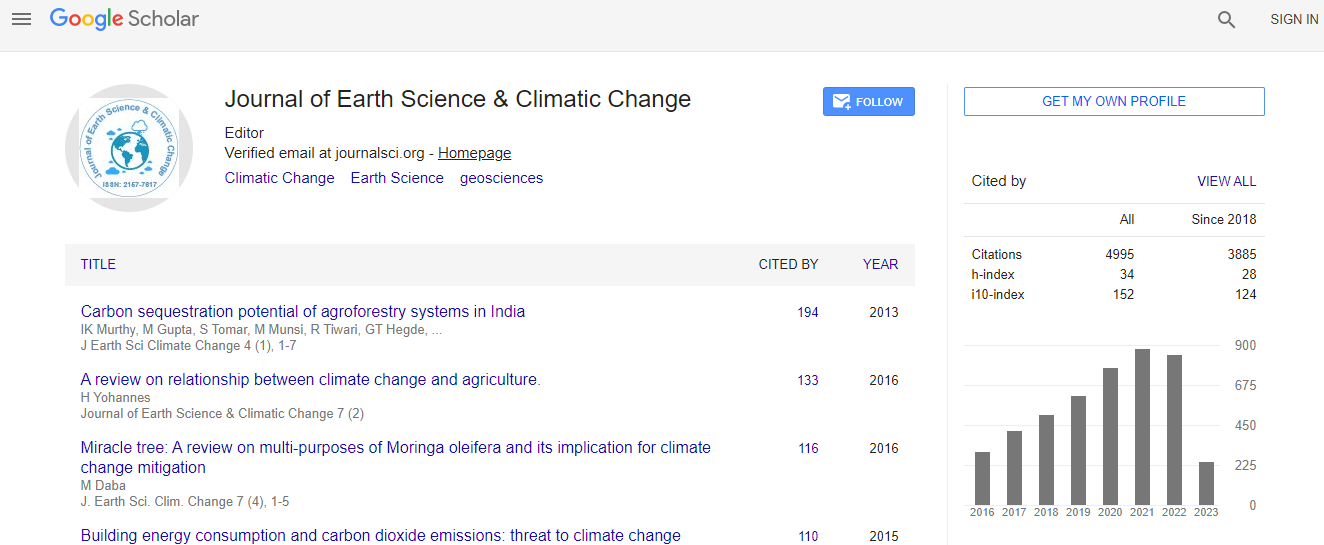
Google Scholar citation report
Citations : 5125
Journal of Earth Science & Climatic Change received 5125 citations as per Google Scholar report
Journal of Earth Science & Climatic Change peer review process verified at publons

Indexed In
- CAS Source Index (CASSI)
- Index Copernicus
- Google Scholar
- Sherpa Romeo
- Online Access to Research in the Environment (OARE)
- Open J Gate
- Genamics JournalSeek
- JournalTOCs
- Ulrich's Periodicals Directory
- Access to Global Online Research in Agriculture (AGORA)
- Centre for Agriculture and Biosciences International (CABI)
- RefSeek
- Hamdard University
- EBSCO A-Z
- OCLC- WorldCat
- Proquest Summons
- SWB online catalog
- Publons
- Euro Pub
- ICMJE
Useful Links
Recommended Journals
Related Subjects
Share This Page
In Association with

Failure mechanism of Rangwamual Landslide, Aizawl, Mizoram, India
5th International Conference on Earth Science & Climate Change
Rahul Verma, Ch U B Rao, John Blick and P C Lainthangpuii
Pachhunga University College, India Mizoram University, India
ScientificTracks Abstracts: J Earth Sci Clim Change
Abstract
Mizoram is one of the most landslide prone states of India. Majority of the landslides in the state, are triggered by the natural factors like climate, physiography and geoenvironment. The prime causes of the landslides in the state can be listed as rugged topography, Tertiary sedimentary geology, steeper slopes, heavy rainfall and location in Seismic zoneâ�?�?V. The rock types of the region consist of sandstones and shales of Bhuban Formation of Surma Group (Middle Miocene), and are very prone to weathering & erosion and subsequent failure under external factors. The present case study pertains to the analyses of the â�?�?failure mechanismâ�? of â�?�?Rangwamual Landslideâ�? of Aizawl District of Mizoram, India which falls on the very strategic National Highway No.44 A, connecting Aizawl town to the stateâ�?�?s only airport at Lengpui. The slide location lies between latitudes 23�?º44�?´57.8â�?N and 23�?º45â�?�?02.8â�?�?â�?�?N and longitudes 92�?º41â�?�?40.76â�? and 92�?º41â�?�?42.51â�? E. The slide occurred in the first week of November; 2014. The failure mechanism of the present slide has been revealed on the basis of integrated analyses of field database using Survey of India Toposheet No.84 A/9 at 1:20000 scale and GIS database (Satellite Data IRS P6/ LISS4 -5.8 Mts. Resolution) using ARCGIS 9.3. Digital Elevation Model (DEM) and Triangulated Irregular Network (TIN) show a variation of elevation from lowest 593 to highest 1153 in the slide section. Both, TIN & DEM models clearly indicate that, from the central ridge, the maximum decline in elevation is in west south west and west direction. Beds also dip due west in general and the dip direction also coincides with the slope trend. The â�?�?rose diagramâ�? plotted for the beds of the slide section, show a â�?�?mean direction of 272.8�?°. The slope generated with CARTOSAT digital elevation model with the help of Arc Map tools, also reveals maximum steepness of the slope from the central ridge, in the same mean direction. Intercalation of shale and sandstone as the prominent lithology, is found to dip due westward where the highway lies. The heavy monsoonal rainfall of more than 500 mm, between June to October, 2014, had triggered the slope disequilibrium and weakening of the slope material. The rain water seeped into the shale â�?�? sandstone contacts following the dip direction and it led to the reduction in cohesive strength by adding weight to the slope material and thereby reducing the angle of repose. The weakened slope material slided down under the conjugate factorial effect of dip, slope, lithological interface and rainfall.Biography
Rahul Verma has completed his PhD from Banaras Hindu University, India and possesses more than 15 years of teaching and research experience along with 4 years of industrial experience. He is a senior faculty member of Department of Geology, Mizoram University, India. He has published 25 papers in reputed journals/edited volumes and is author of 2 books. Recently, he has received a national award for excellence in science. Also, he has been serving as an Editorial Board Member of few journals of repute.
Email: vrahul24@gmail.com