 Spanish
  Chinese
  Russian
  German
  French
  Japanese
  Portuguese
  Hindi
Hindi Our Group organises 3000+ Global Conferenceseries Events every year across USA, Europe & Asia with support from 1000 more scientific Societies and Publishes 700+ Open Access Journals which contains over 50000 eminent personalities, reputed scientists as editorial board members.
Open Access Journals gaining more Readers and Citations
700 Journals and 15,000,000 Readers Each Journal is getting 25,000+ Readers
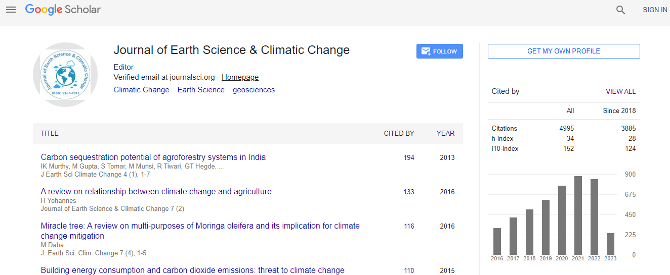
Google Scholar citation report
Citations : 5125
Journal of Earth Science & Climatic Change received 5125 citations as per Google Scholar report
Journal of Earth Science & Climatic Change peer review process verified at publons

Indexed In
- CAS Source Index (CASSI)
- Index Copernicus
- Google Scholar
- Sherpa Romeo
- Online Access to Research in the Environment (OARE)
- Open J Gate
- Genamics JournalSeek
- JournalTOCs
- Ulrich's Periodicals Directory
- Access to Global Online Research in Agriculture (AGORA)
- Centre for Agriculture and Biosciences International (CABI)
- RefSeek
- Hamdard University
- EBSCO A-Z
- OCLC- WorldCat
- Proquest Summons
- SWB online catalog
- Publons
- Euro Pub
- ICMJE
Useful Links
Recommended Journals
Related Subjects
Share This Page
In Association with

GIS based assessment effect of irrigation on groundwater level changes in agricultural areas: A case study on the Bismil plain in the Upper Tigris Basin
2nd International Conference on Geology
Recep Celik
Dicle University, Turkey
ScientificTracks Abstracts: J Earth Sci Clim Change
Abstract
In the recent years, the use of groundwater in agricultural areas for irrigation is being increased rapidly. Unconscious usage of water for irrigation threatens groundwater reserves. There is no need of discussing the importance of the groundwater resources. Economic activities at Bismil, a district of the Diyarbakir province, depend mainly on agriculture and animal husbandry in the Upper Tigris Basin. Tigris River lies through the middle part of the Bismil plain. Bismil plain agricultural irrigation is obtained especially from groundwater by wells. And at coasts of Tigris River, irrigation is provided by pumping the water directly from the river during the irrigation session. However, the consumption more than feeding of the groundwater resources poses a serious threat for the groundwater resources. For this reason, the changes in the groundwater levels have been studied using the data relevant to the water wells during the last 15 years. Three hundred and sixteen wells drilled for watering purposes between the years, 1996-2011 have been examined. The drilling data was ranked with the aid of Microsoft Excel software, and the coordinates have been arranged accordingly. These data were run on the ARC Map software. The data that have been converted to shape (shp) format have been modelled through Spatial analyze.Biography
Recep Çelik is an Assistant Professor at the Department of Civil Engineering, Dicle University, Turkey. He has completed his University (Civil Engineering) and Master’s Programme (Geotechnical Engineering) in �?°stanbul Technical University and PhD (Hydraulic Engineering) from F�?±rat University. He has been working in Dicle Engineering Faculty at Civil Engineering Department since 2013. He has published more than 10 papers and presented 7 papers in International Congresses and Symposia. He has studied groundwater, water resources and GIS modelling.
Email: recep.celik@dicle.edu.tr