 Spanish
  Chinese
  Russian
  German
  French
  Japanese
  Portuguese
  Hindi
Hindi Our Group organises 3000+ Global Conferenceseries Events every year across USA, Europe & Asia with support from 1000 more scientific Societies and Publishes 700+ Open Access Journals which contains over 50000 eminent personalities, reputed scientists as editorial board members.
Open Access Journals gaining more Readers and Citations
700 Journals and 15,000,000 Readers Each Journal is getting 25,000+ Readers
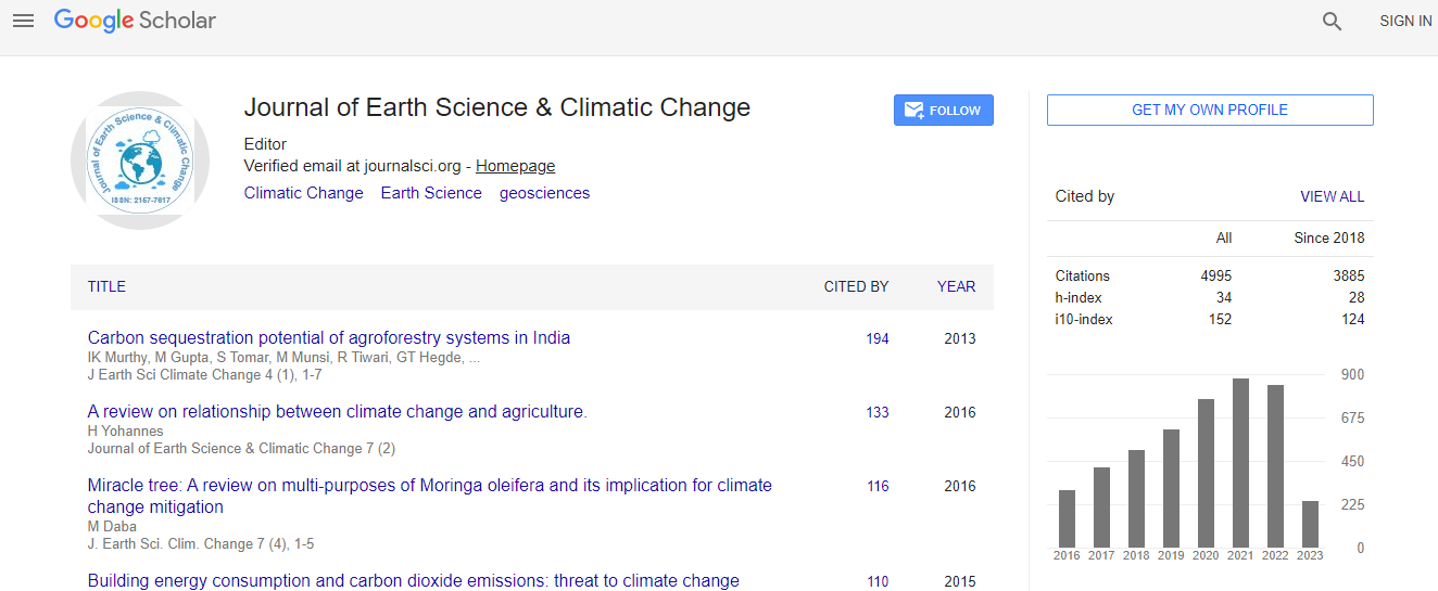
Google Scholar citation report
Citations : 5125
Journal of Earth Science & Climatic Change received 5125 citations as per Google Scholar report
Journal of Earth Science & Climatic Change peer review process verified at publons

Indexed In
- CAS Source Index (CASSI)
- Index Copernicus
- Google Scholar
- Sherpa Romeo
- Online Access to Research in the Environment (OARE)
- Open J Gate
- Genamics JournalSeek
- JournalTOCs
- Ulrich's Periodicals Directory
- Access to Global Online Research in Agriculture (AGORA)
- Centre for Agriculture and Biosciences International (CABI)
- RefSeek
- Hamdard University
- EBSCO A-Z
- OCLC- WorldCat
- Proquest Summons
- SWB online catalog
- Publons
- Euro Pub
- ICMJE
Useful Links
Recommended Journals
Related Subjects
Share This Page
In Association with

Mapping of volcanogenic massive sulphide (VMS) deposits of using satellite data
2nd International Conference on Geology
Rajendran Sankaran and Sobhi Nasir
Sultan Qaboos University, Oman
ScientificTracks Abstracts: J Earth Sci Clim Change
Abstract
Volcanogenic Massive Sulphide (VMS) deposits are typical Cyprus-type and occur in the Oman Ophiolite as clusters of pyritic copper-rich mounds with gold bearing gossans. The occurrence of deposits is abundant in Sohar��?Shinas region of East Al-Batina coast region of the Sultanate of Oman. This work describes the spectral absorption characters of the minerals of the deposits and demonstrates the methods to map the deposit. The spectral absorption character of minerals namely epidote, chlorite, pyrophyllite, illite, calcite, dolomite, pyrite, siderite and hematite are studied and the image processing methods namely band ratios, principal component analysis (PCA), spectral angle mapper, linear spectral unmixing (LSU) and spectral feature fitting (SFF) were applied to map and discriminate the minerals and rocks of the deposits using Landsat 8 and ASTER data. The results of study evaluated in the field to show the sensor capability potential of the image processing methods.Biography
Sankaran Rajendran received the PhD degree in Geology from the Bharathidasan University, India, in 1996. From 2002 to 2010, he was an Assistant Professor with the Department of Earth Sciences, Annamalai University, India. Currently, he is working in the Department of Earth Sciences, Sultan Qaboos University, Oman. His research interests involve mapping mineral and environmental resources of earth using remote sensing and GIS techniques.
Email: rajendra@squ.edu.om