Dersleri yüzünden oldukça stresli bir ruh haline sikiş hikayeleri bürünüp özel matematik dersinden önce rahatlayabilmek için amatör pornolar kendisini yatak odasına kapatan genç adam telefonundan porno resimleri açtığı porno filmini keyifle seyir ederek yatağını mobil porno okşar ruh dinlendirici olduğunu iddia ettikleri özel sex resim bir masaj salonunda çalışan genç masör hem sağlık hem de huzur sikiş için gelip masaj yaptıracak olan kadını gördüğünde porn nutku tutulur tüm gün boyu seksi lezbiyenleri sikiş dikizleyerek onları en savunmasız anlarında fotoğraflayan azılı erkek lavaboya geçerek fotoğraflara bakıp koca yarağını keyifle okşamaya başlar

GET THE APP

Using Landscape Metrics To Evaluate The Change Of Landslide And Vegetation Restorative Area In Nanhua Reservoir Watershed, Taiwan | 27182
ISSN: 2157-7617

Journal of Earth Science & Climatic Change
Open Access

Our Group organises 3000+ Global Conferenceseries Events every year across USA, Europe & Asia with support from 1000 more scientific Societies and Publishes 700+ Open Access Journals which contains over 50000 eminent personalities, reputed scientists as editorial board members.

Open Access Journals gaining more Readers and Citations
700 Journals and 15,000,000 Readers Each Journal is getting 25,000+ Readers

This Readership is 10 times more when compared to other Subscription Journals (Source: Google Analytics)
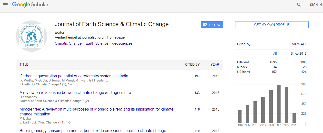
Google Scholar citation report
Citations : 5125

Journal of Earth Science & Climatic Change received 5125 citations as per Google Scholar report

Journal of Earth Science & Climatic Change peer review process verified at publons
Indexed In
  • CAS Source Index (CASSI)
  • Index Copernicus
  • Google Scholar
  • Sherpa Romeo
  • Online Access to Research in the Environment (OARE)
  • Open J Gate
  • Genamics JournalSeek
  • JournalTOCs
  • Ulrich's Periodicals Directory
  • Access to Global Online Research in Agriculture (AGORA)
  • Centre for Agriculture and Biosciences International (CABI)
  • RefSeek
  • Hamdard University
  • EBSCO A-Z
  • OCLC- WorldCat
  • Proquest Summons
  • SWB online catalog
  • Publons
  • Euro Pub
  • ICMJE
Share This Page

Using landscape metrics to evaluate the change of landslide and vegetation restorative area in Nanhua reservoir watershed, Taiwan

4th International Conference on Earth Science & Climate Change

Jie-Lun Chiang, Ssu-Hsuan Chang, Kuang-Jung Tsai and Yie-Ruey Chen

Posters-Accepted Abstracts: J Earth Sci Clim Change

DOI: 10.4172/2157-7617.S1.019

Abstract
Nan-hua reservoir is an important water conservancy facility and habitat in southern Taiwan. Due to vulnerability of geological condition, typhoons and heavy rain cause serious erosion and sediment in Nan-hua watershed. In 2009, typhoon Morakot caused sediment amounted to 17,060,000 m3 and also brought uncertainty of water supply. As a result, to renovate landslides of watershed is an important issue for the operation of reservoir. In this study, SPOT image and landscape metrics are used to analyze the variations and characteristics of the patch which is seen as vegetation restorative of landslide 2008-2012. Maximum likelihood classifier was used in this study. The features of classification included green, red and nearinfrared, short-wavelength infrared band of SPOT and normalized difference vegetation index (NDVI). We classified the land cover into three categories: Vegetation, bare soil, and water. The overall accuracies of classification can achieve higher than 99%. Then, the landslide areas were selected from the classified images. The area of landslide is reduced from 745(ha) in year 2008 to 247(ha) in year 2012. The number of patches (NP) is reduced from 3510 to 1326, and patch density (PD) is reduced from 32.5 to 12.28 in year 2008 to 2012, respectively. The results show that some indices including NP, PD and mean patch size (AREA_MN) increase along with the typhoon rainfall amount. But there is no significant relationship between largest patch index (LPI) and typhoon rainfall amount. The results of this study indicate those indices are suitable for identifying rainfallinduced landslide.
Biography
Jie-Lun Chiang received his BS degree in Hydraulic Engineering from Feng Chia University in 1994, the MS degree in Agriculture Engineering in 1996 and PhD degrees in Bioenvironmental System Engineering in 2006 from National Taiwan University. He is currently an Associate Professor in GIS and remote sensing with the Department of Soil and Water Conservation, National Pingtung University of Science & Technology, Taiwan. His research interests include hydrology, GIS and remote sensing application to watershed management, uncertainty of temporal-spatial data, and climate change impact on soil and water resources.
Top