Dersleri yüzünden oldukça stresli bir ruh haline sikiş hikayeleri bürünüp özel matematik dersinden önce rahatlayabilmek için amatör pornolar kendisini yatak odasına kapatan genç adam telefonundan porno resimleri açtığı porno filmini keyifle seyir ederek yatağını mobil porno okşar ruh dinlendirici olduğunu iddia ettikleri özel sex resim bir masaj salonunda çalışan genç masör hem sağlık hem de huzur sikiş için gelip masaj yaptıracak olan kadını gördüğünde porn nutku tutulur tüm gün boyu seksi lezbiyenleri sikiş dikizleyerek onları en savunmasız anlarında fotoğraflayan azılı erkek lavaboya geçerek fotoğraflara bakıp koca yarağını keyifle okşamaya başlar
Reach Us +1-845-458-6882

GET THE APP

Developments And Benefits Of Marine Geospatial Data Derived From Remotelysensed Satellite Imagery | 9515
ISSN: 2155-9910

Journal of Marine Science: Research & Development
Open Access

Our Group organises 3000+ Global Conferenceseries Events every year across USA, Europe & Asia with support from 1000 more scientific Societies and Publishes 700+ Open Access Journals which contains over 50000 eminent personalities, reputed scientists as editorial board members.

Open Access Journals gaining more Readers and Citations
700 Journals and 15,000,000 Readers Each Journal is getting 25,000+ Readers

This Readership is 10 times more when compared to other Subscription Journals (Source: Google Analytics)
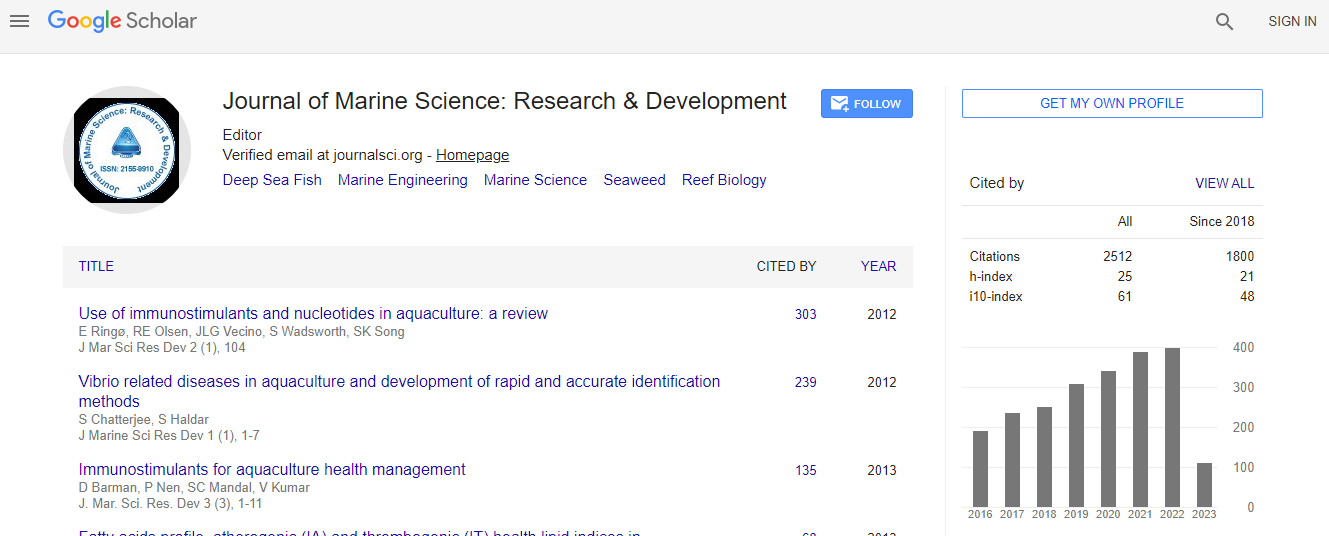
Google Scholar citation report
Citations : 2494

Journal of Marine Science: Research & Development received 2494 citations as per Google Scholar report

Indexed In
  • CAS Source Index (CASSI)
  • Index Copernicus
  • Google Scholar
  • Sherpa Romeo
  • Open J Gate
  • Genamics JournalSeek
  • Academic Keys
  • ResearchBible
  • Ulrich's Periodicals Directory
  • Electronic Journals Library
  • RefSeek
  • Directory of Research Journal Indexing (DRJI)
  • Hamdard University
  • EBSCO A-Z
  • OCLC- WorldCat
  • Scholarsteer
  • SWB online catalog
  • Virtual Library of Biology (vifabio)
  • Publons
Share This Page

Developments and benefits of marine geospatial data derived from remotelysensed satellite imagery

International Conference on Oceanography & Natural Disasters

Robert Carroll

Accepted Abstracts: J Marine Sci Res Dev

DOI: 10.4172/2155-9910.S1.004

Abstract
This paper reviews the methodology and real world case studies related to deriving marine geospatial data, including bathymetric survey, seabed classification, and water quality monitoring from commonly available georeferenced imagery. The recent and planned launches of enhanced high resolution imagery satellites by government agencies and commercial operators is enabling broad area coverage with increased refresh frequency. Combined with a new approach and methodology for imagery analysis and processing called Modular Inversion Program (MIPS), these systems now enable rapid and cost-effective global marine geospatial data creation without the need to deploy equipment and resources. These data services enable a wide range of evolving applications including dredging monitoring, environmental monitoring of off shore construction, ecological status monitoring coastal zones, natural disaster risk analysis, algae bloom tracking, and fresh water quality monitoring. These new techniques and the impact on hydrographic surveying will be reviewed through a number of case studies including samples of project work delivered to the United Kingdom Hydrographic Office (UKHO), Geological Survey of Ireland (GSI), and GMES FRESHMON. In addition, the current and planned state of appropriate satellite imagery platforms and detailed review of the processing system components will be explored by this paper.
Biography
Robert Carroll represents Proteus FTC and its EOMAP marine geospatial services in North America. He has worked with federal and local government agencies to improve work flow efficiencies through remote sensed information. With 25 years of experience in the geomatic and remote sensing industry, he has worked globally with industry leading companies including pictometry, Hitachi, and Esri. He has been widely published in many geomatic and industry specific journals and has spoken around the world at numerous conferences.
Top