 Spanish
  Chinese
  Russian
  German
  French
  Japanese
  Portuguese
  Hindi
Hindi Our Group organises 3000+ Global Conferenceseries Events every year across USA, Europe & Asia with support from 1000 more scientific Societies and Publishes 700+ Open Access Journals which contains over 50000 eminent personalities, reputed scientists as editorial board members.
Open Access Journals gaining more Readers and Citations
700 Journals and 15,000,000 Readers Each Journal is getting 25,000+ Readers
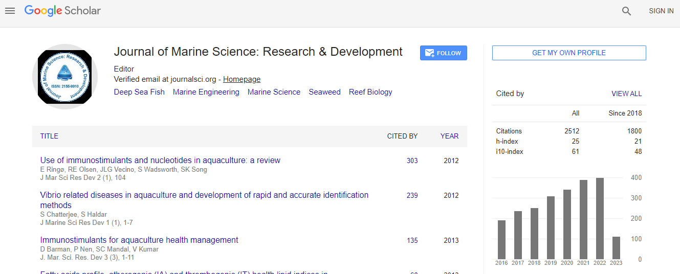
Google Scholar citation report
Citations : 3189
Indexed In
- CAS Source Index (CASSI)
- Index Copernicus
- Google Scholar
- Sherpa Romeo
- Open J Gate
- Genamics JournalSeek
- Academic Keys
- ResearchBible
- Ulrich's Periodicals Directory
- Electronic Journals Library
- RefSeek
- Directory of Research Journal Indexing (DRJI)
- Hamdard University
- EBSCO A-Z
- OCLC- WorldCat
- Scholarsteer
- SWB online catalog
- Virtual Library of Biology (vifabio)
- Publons
Useful Links
Recommended Journals
Related Subjects
Share This Page
Geological Investigation of Submarine Hydrothermal Vents as Geothermal Manifestation in Weh Island, Nangroe Aceh Darussalam Province, Indonesia
4th International Conference on Oceanography & Marine Biology
Kiki Dewangga, Rinaldi Ikhram, Irfan Arifin and Hananto Kurnio
Faculty of Geological Engineering, Padjadjaran University, Indonesia Marine Geological Institute of Indonesia (PPPGL), ESDM, Indonesia
Posters & Accepted Abstracts: J Marine Sci Res Dev
Abstract
Weh Island is located in Nangroe Aceh Darussalam (NAD) Province, in the city of Sabang, at 95Г?В° 12ГўВ?В? 00ГўВ?Вќ-05Г?В° 23ГўВ?В? 00ГўВ?Вќ longitude and 05Г?В° 46ГўВ?В? 00ГўВ?Вќ - 05Г?В° 55ГўВ?В? 00ГўВ?Вќ latitude. This is one of the most recent volcanic islands in Sunda orogenic belt which span from Andaman Sea to Banda. This is a type C volcano which means the eruption center of the volcano is unknown but it have fumarole field which is a sign of a past volcanic activity. Based on petrographic and geochemistry analysis show that the type of volcanic rocks found are basalt-andesite. The magma type is tholeiitic and the tectonic environment of volcanic rocks is ГўВ?Вќspreading center islandГўВ?Вќ. This result is compatible with tectono-structural of Great Sumatra strike ГўВ?В?slip fault which is related to active spreading ГўВ?В? arc basin. The structural deformation is a result from Pliosen ГўВ?В? Pleistosen tectonic and volcanic activity which is indicated by discovery of the remnant of ancient volcanoes, lineament of volcanic cone, fault scrap, volcanic depression, and lineament of eruption center and also hydrothermal activity as result of past volcanism.Hydrothermal activity discovered in the sea and land of this area. Research about submarine fumarole have been conducted by the Marine Geological Institute of Indonesia (PPPGL) indicate that there is a large amount of submarine fumarole in this area. In the depth 10 meter, the submarine fumarole originated from joints or fissure with a north ГўВ?В? south bearing, whereas in the depth of 40 ГўВ?В? 50 meter these fumarole mostly formed on top of an undulation which have a similar form as a crater. Based on the location of these fumarole, Semangko strike ГўВ?В?slip fault is assumed to have a significant role in the formation and development of it. The fault made joints and fissures on the seabed which make hydrothermal circulation possible.Biography
Email: rinaldikhram@gmail.com