ISSN: 2155-9910

Journal of Marine Science: Research & Development
Open Access

Our Group organises 3000+ Global Conferenceseries Events every year across USA, Europe & Asia with support from 1000 more scientific Societies and Publishes 700+ Open Access Journals which contains over 50000 eminent personalities, reputed scientists as editorial board members.

Open Access Journals gaining more Readers and Citations
700 Journals and 15,000,000 Readers Each Journal is getting 25,000+ Readers

This Readership is 10 times more when compared to other Subscription Journals (Source: Google Analytics)
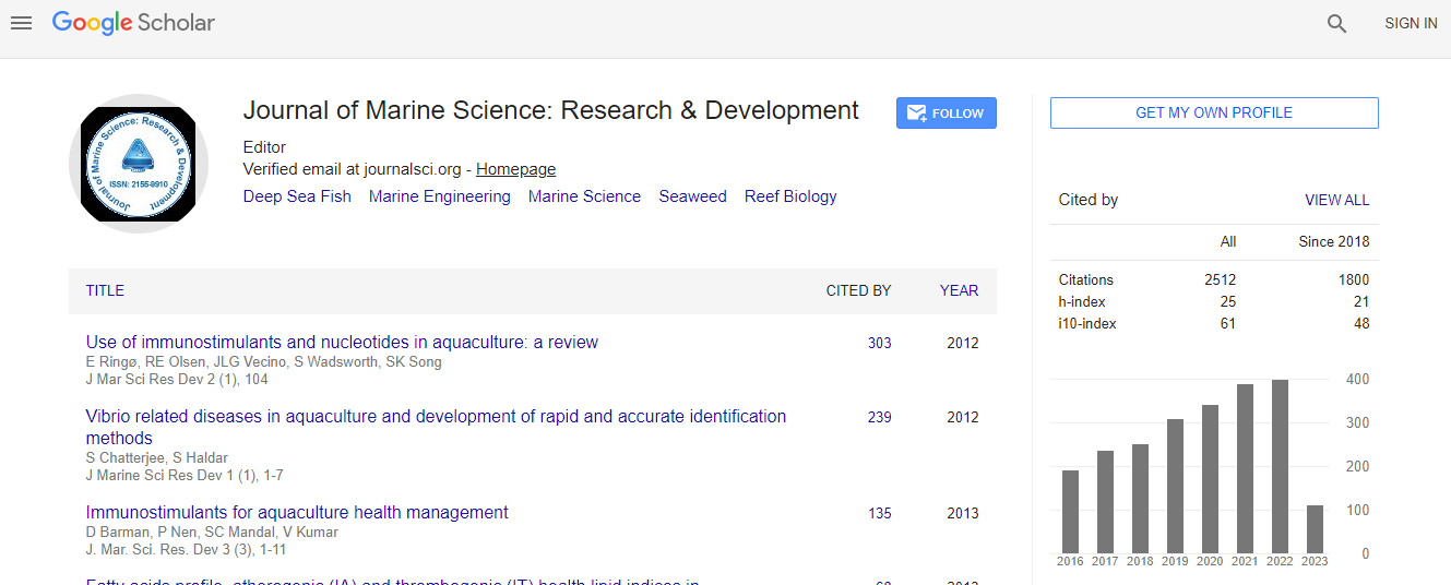
Google Scholar citation report
Citations : 2494

Journal of Marine Science: Research & Development received 2494 citations as per Google Scholar report

Indexed In
  • CAS Source Index (CASSI)
  • Index Copernicus
  • Google Scholar
  • Sherpa Romeo
  • Open J Gate
  • Genamics JournalSeek
  • Academic Keys
  • ResearchBible
  • Ulrich's Periodicals Directory
  • Electronic Journals Library
  • RefSeek
  • Directory of Research Journal Indexing (DRJI)
  • Hamdard University
  • EBSCO A-Z
  • OCLC- WorldCat
  • Scholarsteer
  • SWB online catalog
  • Virtual Library of Biology (vifabio)
  • Publons
Share This Page

Validation of mangrove area in maros regencies, Indonesia of republic by using remote sensing and geographical information system

International Conference on Oceanography & Natural Disasters

Andi Gusti Tantu, Ahmad Mustafa, Ratnawati and Mardiana

Accepted Abstracts: J Marine Sci Res Dev

DOI: 10.4172/2155-9910.S1.004

Abstract
Mangroves lived on the edge of two environments. With one foot on land and another in the sea, mangroves could be called as botanical amphibian. It occupied a zone which was characterized by desiccating heat, choking mud, and salt levels that would kill an ordinary plant within hours. Mangroves forest was one of the most productive and biologically complex ecosystems on Earth. Birds roosted in mangroves canopy, shellfish was attaching themselves to mangroves roots, and snakes came to mangroves for hunt. Mangroves provided nursery grounds for fish, a food for crabs, and even a nectar source for bats and honeybees. The objective of research was to understand mangroves width at Maros District in 2012. To obtain final data of mangroves width in Maros District, thus it was validated through satellite imaging. The satellite imaging device was Citra Spot-4 of Acquisition 2010. The image of mangroves width was then classified. The previous data were processed by Landsat-7 ETM+ of Acquisition 2002, which were digitized and spatially analyzed using GIS. Result of analysis indicated that mangroves width at Maros District in 2002 was 757.30 ha, but it decreased to 269.49 ha in 2012. The reduction of mangrove wide was mostly due to the land conversion to the embankment and settlement areas.
Biography
Relevant Topics
Top